GEOLOGICAL
MAPPING
AND
PETROGRAPHIC
STUDY
OF
THE
BUGARAMA
TUNGSTEN
MINERALISATION,
NORTHERN
RWANDA
Sam De Saeger
Student number: 01510210Promotor: Prof. dr. Stijn Dewaele
Jury: Prof. dr. Johan De Grave, Dr. Niels Hulsbosch
Master’s dissertation submitted in partial fulfilment of the requirements for the degree of master in geology Academic year: 2019-2020
I
Preface
For my masterthesis I investigated the geology and mineralogy of the tungsten mineralisation exploited at the Bugarama mine in northern Rwanda.
First of all I would like to thank my promotor Prof Dr Stijn Dewaele for giving me the chance to do this project. His knowledge of the region and his contacts with New Bugarama Mining were indispensable to organise the fieldwork. His insight and suggestions both on the field, and later during the processing of the data and writing were very helpful to complete this project.
Of course I would also like to thank everyone from New Bugarama Mining that made it possible for me to stay and work at the mine during three weeks. I am thankful for Mr Quentin Lamarche without whom this fieldwork would not have been possible. I would like to thank Mr Vincent Ruganintwali for organising all practical arrangements for my visit, everything going from my transportation and stay, to transporting the samples back to Belgium. Also thanks to Mr Janvier Ndabananiye for letting me work at Bugarama and being so welcome to me. A special thanks to Rose and Aimable for assisting and accompanying me during the three weeks of fieldwork, both during the work and during free time. I think I can say we became friends for life and I hope to see them many more times in the future. Of course there are many others in Rwanda that helped in some way, also thanks to them.
II
Preample
In a first stage of my research, fieldwork has been carried out at the Bugarama mine in the northern part of Rwanda. My fieldwork took place during three weeks in the summer of 2019. A detailed mapping of several galleries and surface outcrops has been done. Samples were collected for further mineralogical and petrographic research at Ghent University. In the second stage, the samples were investigated both macroscopically and microscopically. The latter was done on thin sections from 20 out of 40 samples. Based on all of this information, a paragenetic sequence of the tungsten mineralisation at Bugarama was constructed.
Due to the lockdown by the coronavirus, there was only a brief period available for microscopic investigations. It was envisaged that extra mineralogical and geochemical information could have been collected by doing X-ray analyses (XRD) and scanning electron microscopy (EDS and SEM). No XRD or scanning electron microscope analyses were carried out. Incident light microscopy of the ore minerals would have helped to distinguish wolframite from other opaque minerals, but has not been done either. The masterthesis was, therefore, finished based on all the data, that was collected during the fieldwork, and the mineralogical and petrographic analyses done in the weeks prior to the lockdown of the university.
III
Table of contents
Preface... I
Preample ... II
Table of contents ... III
The story of my research ... 1
Introduction ... 2
Geology of the Bugarama area ... 3
1. Introduction ... 3
2. Regional geology ... 3
2.1. Karagwe-Ankole belt (KAB) ... 3
2.2. Lithostratigraphy ... 5
2.3. Magmatic and metamorphic history ... 7
3. Geology northern part of Rwanda ... 9
4. Geology Bugarama mine: historical studies ... 12
Tungsten mineralisation... 15
1. General ... 15
2. Rwanda ... 17
2.1. Gifurwe ... 19
2.2. Nyakabingo ... 20
Material and methods ... 21
1. Fieldwork ... 21
2. Petrography ... 24
Results... 25
1. Fieldwork ... 25
1.1. Description galleries and outcrop ... 25
1.1.1. Bugarama ... 25
1.1.2. Kabindi ... 29
1.1.3. Murundi ... 31
1.1.4. Fumbwe ... 33
1.1.5. Rubona ... 36
1.1.6. Sozi Hill ... 40
1.1.7. Rusagara Hill ... 40
IV
1.2. Geological map ... 40
1.3. Conclusion ... 43
2. Petrography ... 44
2.1. Macroscopic and microscopic description ... 44
2.1.1. Host-rocks of Bugarama mine ... 44
2.1.1.1. Quartzite & sandstone ... 44
2.1.1.2. Sandy siltstone ... 48
2.1.1.3. Shale ... 51
2.1.1.4. Graphitic shale ... 54
2.1.2. Quartz veins ... 55
2.1.2.1. Folded, bedding-parallel veins ... 55
2.1.2.2. Thick, bedding-parallel veins ... 56
2.1.2.3. Crosscutting veins ... 59
2.1.2.4. Hydraulic fractured rocks ... 60
2.2. Conclusion and paragenesis ... 61
Discussion: Bugarama deposit... 64
1. Geological and lithological control ... 64
2. Structural setting ... 65
3. Paragenesis ... 66
Conclusions ... 69
Bibliography ... 73
Appendices ... 77
Appendix A: Fieldwork observations ... 77
Appendix B: Sample list ... 117
1
The Story of my Research
The most exciting part about this masterthesis for me was of course the fieldwork to Rwanda. This was one of the major reasons why I chose this subject in the first place. How many chances does one ever get to go work in an active mine in Central Africa. Terrain experience is in my opinion one of the more fun parts of studying geology, especially when it is in a foreign country. Everything going from the planning of the fieldwork to actually being there, was one of the most interesting and amazing things I did during my five years of studying geology.
The start of the fieldwork in July 2019 wasn't very promising as the flight to Kigali got cancelled and I had to leave a day later. When finally there it was obvious that the atmosphere was completely different than in Belgium. Lots of people walking around, lots of bicycles and lots of noise, but most importantly everyone is super friendly. At the mine itself, I was welcomed with open arms and introduced to everyone. Two people from the mine, Rose and Aimable, were assigned to accompany and help me during my stay. I think I can say we started as co-workers, but ended as friends. The fieldwork itself was set at Bugarama mine in a beautiful environment which compensated to ascending and descending the different hills. Every day we went into the tunnels or walked on the terrain to look at the rocks and described them in detail, which was sometimes not so easy in the blazing sun. After two weeks and a half of terrain work I got an offer to stay even a few days longer to visit another mine. So of course I took this opportunity as well. When arriving back home with several kilos of rock samples, I was an experience richer and both the fieldwork as well as the people are something I will never forget.
2
Introduction
Tungsten is an important metal that is crucial in several industries. Due to its unique properties, like its strength and its high melting point, it is indispensable in its many applications. It is used in cutting tools, construction, military purposes, electronics, chemical industry and many other branches (British Geological Survey, 2011). Rwanda is home to the so-called "Tungsten belt" in which several mines exploit this metal (De Magnée and Aderca, 1960). The subject of research for this masterthesis is the Bugarama tungsten mine situated in northern Rwanda. Here the tungsten is contained within quartz veins which were emplaced at circa 986 Ma, together with the G4-granites (Fernandez-Alonso et al., 2012; Tack et al., 2010). These are the parental granites for both Sn (tin) and W (tungsten) mineralisation (Fernandez-Alonso et al., 2012; Tack et al., 2010). Already since the discovery of the ore at Bugarama in 1950 (Pohl, 1973), several studies have been made to help to understand the geology and the structural features in the mine, to estimate the tungsten reserve and to locate the mineralised quartz veins for excavation (De Trey, 1957, Wasilewski, 1972, Pohl, 1973). Several generations of quartz veins were already identified in other mines in Rwanda and Burundi (De Clercq, 2012; Dewaele, 2016). Although there seem a lot of similarities between Bugarama and these different tungsten mines at first sight, there hasn't been a detailed study of the formation history and timing of the W-mineralised quartz veins at Bugarama. The objective for this masterthesis consists of the construction of the geology and a paragenetic sequence of the tungsten mineralisation at Bugarama and to compare this with the other tungsten mineralisations in Rwanda.
In a first part of my research, which took place during the fieldwork campaign, the different galleries at Bugarama were mapped in detail with attention for structural features (folds, faults, foliation). These observations were combined with similar structural data obtained from mapping selected parts of the surface terrain within the concession. The different lithologies and quartz vein generations present were noted and strike and dip measurements of different structural features were taken. Special attention was spent to look for structures as folds and faults. Based on this data, a first rough paragenetic sequence, as well as geological transects and a map were constructed, for further elaborating in the lab at the UGent. In the second part of my research, the samples collected during the fieldwork were described and investigated, both macroscopically and microscopically. By using a hand lens and a petrographic microscope the different minerals were identified, as well as any microstructures that were present.
As a conclusion the results of these two parts are combined to reconstruct a paragenetic model for the mineralisation and gain more information about the formation history of the tungsten mineralisation at Bugarama. This new data is then compared to the literature that is present about tungsten mineralisation in other parts of Rwanda. Similarities and differences between this and between different tungsten mines in Rwanda and the world are then discussed.
3
Geology of the Bugarama area
1. Introduction
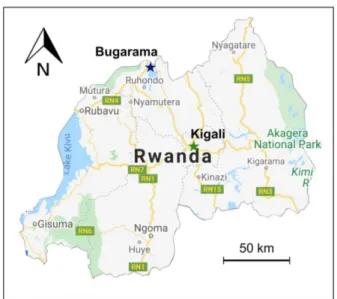
The Bugarama tungsten mine is situated in the Northern Province of Rwanda and is exploited by New Bugarama Mining in the Burera District. The study area is located approximately 70 km northwest of Kigali, near the border with Uganda at the northern shore of Lake Burera (Figure 1). The concession has a total surface area of 8,75 km² of which about 1,20 km² is currently being exploited. The area where there is active work is situated between 1900 and 2000 metres above sea level. The topography around the mine consists of several sharp hills that are NW to SE oriented, while the valleys in between are quite wide and flat.
2. Regional geology
2.1. Karagwe-Ankole belt (KAB)
Rwanda forms part of the Karagwe-Ankole belt (KAB) in Central Africa (Fernandez-Alonso et al., 2012; Tack et al, 2010), which has been submitted to a complex geological history, going back to the Archean. At present, it forms part of the East African Rift system with Lake Kivu and numerous volcanoes as the most clearly visible evidence of this. The KAB has been defined as a belt of Mesoproterozoic supracrustal units, which are mostly metasedimentary rocks with minor amounts of metavolcanic rocks. They are intruded by large Mesoproterozoic S-type granitoid massifs and smaller amounts of mafic rocks (Cahen et al., 1984; Fernandez-Alonso et al., 2012; Tack et al., 2010).
The Karagwe-Ankole belt itself forms part of what has been called the Kibara belt 'sensu latu' (Cahen et al. 1984). This is an approximately 1300 km long, SW-NE oriented Mesoproterozoic orogen that extends from Katanga (Democratic Republic of Congo) in the southwest to Uganda-Tanzania in the northeast, thus
Figure 1: Map of Rwanda with location of the Bugarama tungsten mine (after Google Maps, 2020)
4 covering large parts of eastern Congo (DRC), Burundi, Rwanda, southwest Uganda and northwest Tanzania (Fernandez-Alonso et al., 2012; Tack et al, 2010). It is bordered by the Archaean-Palaeoproterozoic Congo Craton to the west and north, the Archaean Tanzania craton to the east and Bangweulu Block to the south. Because there is a clear disruption of the Kibara belt 'sensu latu' by the NW -SE oriented Paleoproterozoic Ubende-Rusizian terranes in the DRC and Tanzania (Cahen and Snelling, 1966; Lavreau, 1985; Lepersonne, 1974), it has been split up into a southern and a northern part. The southern part which mainly lies within the DRC was named the Kibara belt 'sensu strictu' (KIB) and the northern part covering part of the DRC, Burundi, Rwanda, Uganda and NW Tanzania was re-named the Karagwe-Ankole belt (KAB) (Figure 2) (Tack et al., 2010). These are treated as two separate belts, but they are of the same age (Tack et al., 2010).
The Karagwe-Ankole belt is a fold-and-thrust belt which is split up in an Eastern (ED) and a Western domain (WD) separated by the 350 km-long alignment of the Kabanga-Musongati (KM) mafic and ultramafic Bushveld-type, layered complexes (Figure 3) (Tack et al, 2010). The formation of these complexes is associated with the 1375 Ma bimodal magmatism (Tack et al., 2010). The ED and WD domains have their own magmatic-metamorphic history and each developed individual sedimentary
Figure 2: Sketch map showing the "Karagwe-Ankole belt" (KAB) and the "Kibara belt" (KIB) (Cahen and Snelling, 1966)
Figure 3: Sketch map showing the regional framework and division of the the Western (WD) and Eastern Domain (ED) of
5 subbasins, which had different depositional conditions throughout time (Fernandez-Alonso et al., 2012). Our study area is located in the WD.
There is still a lot of discussion about the geodynamical and formation history of the KAB. Two main theories have been proposed: either it formed in an intracratonic setting which experienced two short, far-field compressional events (Klerkx et al., 1987; Fernandez-Alonso et al., 2012; Tack et al., 2010) or in a subduction-collision system (Debruyne et al., 2014; Fernandez-Alonso et al., 2012; Klerkx et al., 1987; Tack et al., 2010). The most important magmatic event in the KAB occurred around 1375 Ma and will be discussed later. The most important compressional event occurred around 1 Ga (also see "2.3 Magmatic and metamorphic history") and was the result of far-field stresses related to the amalgamation of Rodinia. Because of this the metasedimentary rocks of the WD were folded and thrusted. Post-compressional relaxation allowed the emplacement of the Sn-metallogenic province around 986 Ma (Fernandez-Alonso et al., 2012).
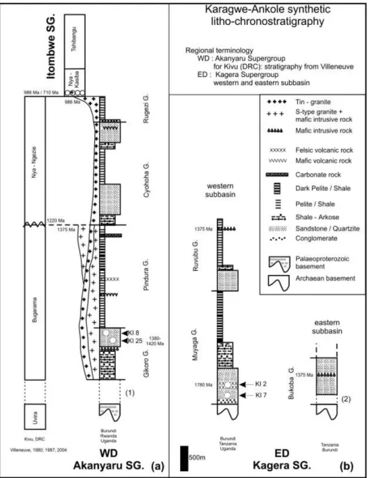
2.2. Lithostratigraphy
The WD and ED both evolved independently based on their depositional history (Baudet et al. 1989). Three sedimentation periods are recorded spanning the last part of the Paleoproterozoic and the Mesoproterozoic (Fernandez-Alonso et al., 2012). Sediments were deposited in two individual subbasins under different conditions and as such instead of one general lithostratigraphy for the WD and ED, there are two separate ones (Figure 4). For the WD, these sediments are grouped in the Akanyaru Supergroup, which contains four groups: Gikoro, Pindura, Cyohoha and Rugezi (Fernandez-Alonso et al., 2012; Tack et al., 2010). These four groups contain greenschist to amphibolite facies metasedimentary rocks (Fernandez-Alonso et al., 2012). The rocks of the WD are intruded by different generations of S-type granitoid rocks and smaller amounts of mafic rocks (Fernandez-Alonso et al., 2012). The S-type granites from around 1375 Ma only intruded the lower Gikoro and Pindura Group, therefore a stratigraphic break was suggested between the lower Gikoro-Pindura and upper Cyohoha-Rugezi groups (Fernandez-Alonso et al., 2012). Something else that might suggest a hiatus is the abundant and clear presence of the S1-fabric in the lower two groups, but its absence in the top two (Theunissen, 1988). However no uncomformity has yet been identified. The metasediments in the ED are stratigraphically divided in the Muyaga, Ruvubu and Bukoba groups of the Kagera Supergroup (Fernandez-Alonso et al., 2012). In fact, the ED consists of two smaller subbasins separated from each other by a fault. The Muyaga and Ruvubu groups are located in the smaller western subbasin, while the Bukoba Group is part of the eastern subbasin (Fernandez-Alonso et al., 2012). The Muyaga Group starts at the base with a basal conglomerate which unconformably overlies the Archean craton of Tanzania. There are no S-type granitic bodies and no economic mineralisation which is not the case in the WD (Fernandez-Alonso et al., 2012). Another significant difference between the WD and ED is that where the WD has deformation and metamorphism throughout the entire domain, the ED shows most
6 metamorphism in the west with a decrease in intensity towards the east (see also 2.3 Magmatic and metamorphic history) (Fernandez-Alonso et al., 2012).
Figure 4: Synthetic litho-chronostratigraphic logs of the KAB for the WD (a) and ED (b) (Tack et al., 2010)
Three sedimentation periods can be identified in the KAB (Fernandez-Alonso et al., 2012). The first period started in the ED around 1780 Ma. The Murore felsic tuffs (dated 1780 ± 9 Ma) interlayered with sandstone mark the base of the Kagera Supergroup (Fernandez-Alonso et al., 2012). These unconformably overlie the Archean craton of Tanzania. The ED is then also split into a western and eastern group which were both deposited before c. 1375 Ma, since they were then intruded by mafic and ultramafic magmatism
7 (Fernandez-Alonso et al., 2012). The western and eastern group are respectively called the Muyaga plus Ruvubu Group and the Bukoba Group. Deposits from the Kagera Supergroup can be called a molasse of Eburnean-age (Fernandez-Alonso et al., 2012).
In the second period sedimentation started in the WD with the Akanyaru Supergroup after 1420 Ma (volcanic event), but before 1375 Ma (Fernandez-Alonso et al., 2012). It must be noted that the base of this lithostratigraphic unit was never observed. The Akanyaru Supergroup consists for this time period out of the Gikoro and Pindura Group of which the former is characterised by multiple volcanic intrusions (Fernandez-Alonso et al., 2012). These are related to the 1375 Ma magmatic event, which will be discussed later. Both the Gikoro and Pindura Group consist of siliciclastic sediments (Fernandez-Alonso et al., 2012).
A third sedimentation period started at 1222 Ma and can only be found in the WD. During the interval between the 1375 Ma volcanic intrusions and the 1222 Ma onset of deposition no sediments are recorded (Fernandez-Alonso et al., 2012). It is suggested that there was a depositional and/or erosional hiatus although non of these has been observed. This third period is mostly likely initiated by renewed activity and subsidence of several N-S directed shear zones in the WD both in Rwanda and Burundi. These depositions are also part of the Akanyaru Supergroup and consist consecutively of the siliciclastic sediments of the Cyohoha and Rugezi Group (Fernandez-Alonso et al., 2012).
When going out from the intracratonic setting of the KAB, it was in a relatively stable position with some episodes of extensional stresses and movement which created sedimentation space from the start of sedimentation in the late Paleoproterozoic until the start of the Paleozoic. Only two occasions of compressional activity have been recorded, around 1.0 Ga and 550 Ma, as well as several periods of magmatic activity (Fernandez-Alonso et al., 2012).
2.3. Magmatic and metamorphic history
From the late Paleoproterozoic until the end of the Proterozoic, three magmatic episodes occurred that are important for the geological history of the KAB and Rwanda: at c. 1375 Ma, c. 1205 Ma and c. 986 Ma (Fernandez-Alonso et al., 2012; Tack et al., 2010).
Around 1375 Ma the Gikoro and Pindura metasediments were intruded by bimodal magmatism. This period is called the Kibara event (Tack et al. 2010). The magmatism resulted in a first generation of S-type granites (G1-3), as well as several dolerite bodies and the (ultra-) mafic Bushveld-type Kabanga-Musongati (KM) alignment, which makes the boundary zone between the WD and the ED (Rumvegeri, 1991; Tack et
8 al., 2010). In fact these granites were most likely produced over a period of 50 to 70 million years starting from 1375 Ma (Tack et al., 2010). These S-type granites are emplaced at shallow depths of 5 to 10 km below the surface (Tack et al., 2010). Also worth noting is that the G1-3 granites only occur in the WD. Most likely extensional stresses and the weak zone between the Archean craton and Paleoproterozoic basement made it possible for the magma to rise to the surface. Since no ophiolites or any other evidence of oceanic lithosphere are observed and it is proven that there is Paleoproterozoic basement present underneath the KAB, intra-plate magmatism is the most plausible (Tack et al., 2010). It is related to the unsuccessful continental break-up through rifting and the emplacement of a Large Igneous Province. It is important to mention it is not related to any orogenic cycle. A phase of metamorphism around this time is responsible for the S1-fabric that is at a very small angle with the original S0 orientation (Fernandez-Alonso et al., 2012).
Around 1205 Ma a more local magmatic event emplaced A-type granites along N-S oriented shear zones within the WD (Tack et al., 2010). These form N-S oriented bodies, mostly located within present-day Burundi and are not associated with any mineralisation.
In the last magmatic episode S-type leucogranites intruded the Mesoproterozoic metasediments and the older magmatic rocks around 986 Ma (Tack et al., 2010). These are called ‘Sn granites’, because they are parental granites for Sn mineralisation, or also called ‘G4-granites’. The metallogenic province covering parts of both KAB and KIB contains large amounts of pegmatites with tin and niobium-tantalum containing minerals like for example columbite-tantalite and cassiterite and quartz veins with cassiterite or wolframite. Also the vein-type mineralisations are associated with these granites (Dewaele et al., 2011; Hulsbosch et al., 2014, 2016). Based on fluid inclusion studies it is thought that the tungsten minerals precipitated from an aqueous‐gaseous H2O‐CO2‐CH4‐N2‐NaCl‐(KCl) fluid, with a low to moderate salinity (0.6–13.8 eq. wt%
NaCl) and minimal trapping temperatures between 247 and 344°C (Dewaele et al., 2016). No direct spatial link between the W-mineralised veins and the Sn-granites, from which the fluid would originate, has been observed yet. Granitic bodies below the deposits have however been identified by magnetometric data (Günther and Ndutiye, 1990).
The youngest G4 granite generation was emplaced during post-collisional relaxation shortly after an episode of compressional stresses around 1.0 Ga (Fernandez-Alonso et al., 2012). This short period of deformation was most likely due to far-field stresses caused by the unification of Rodinia and produced the S2-fabric that can be found in rocks that came under pressure from this event (Fernandez-Alonso et al., 2012). A similar period of a compressional regime occurred around 550 Ma and is related to the amalgamation of Gondwana (Dewaele et al., 2011). Apart from these short episodes the KAB was mostly under stable or an extensional stress regime.
9 The intensity of deformation and grade of metamorphism in the KAB increases from east to west. In the ED the metasediments are generally weakly metamorphosed and gently folded, while in the WD greenschist to amphibolite facies metamorphism, as well as clearly more intense deformation are observed (Deblond et al., 2001; Fernandez-Alonso and Theunissen, 1998; Klerkx et al., 1987; Koegelenberg and Kisters, 2014; Tack et al., 2010). Only the western part of the ED shows folding and back-thrusting, while the eastern part is only gently deformed and folded. This deformation was dated by Ar-Ar on muscovite at 1326 ± 10 Ma (Koegelenberg et al., 2015).
3. Geology northern part of Rwanda
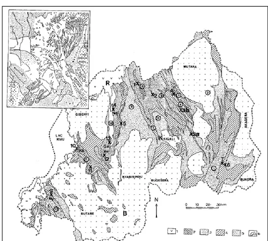
Northern Rwanda consists of a series of parallel anti- and synclinoriums with a NNW-SSE orientation. From east to west these are: S. of Kibungo (1), A. of Mutara (2), S. of Gatsibo (3), A. of Karehe (4), S. of Byumba (5), A. of Rutongo (6), S. of Yanza (7), S. of Miyove (8) and A. of Bumbogo (9) (S.: synclinorium, A.: anticlinorium) (Figure 5)(Baudet et al., 1989).
Figure 5: Simplified geological map of Rwanda. The numbers in the circles correspond to the number used in the text for the different synclines and anticlines (Baudet et al., 1989)
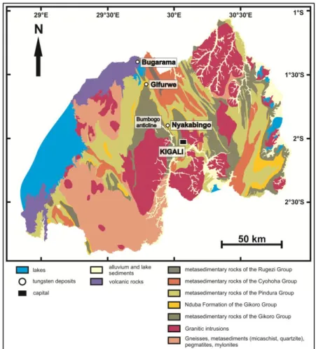
10 Of these, the Bumbogo anticline is of most interest for this research since this is the structure in which the Bugarama tungsten mine as well as the equally important Nyakabingo and Gifurwe mines are located (Figure 6). They are aligned along the NNW-SSE oriented anticline which plunges at a low angle towards the NNW.
Figure 6: Geological map of Rwanda with the different lithostratigraphic units and showing the most important tungsten deposits (Goldmann, 2013)
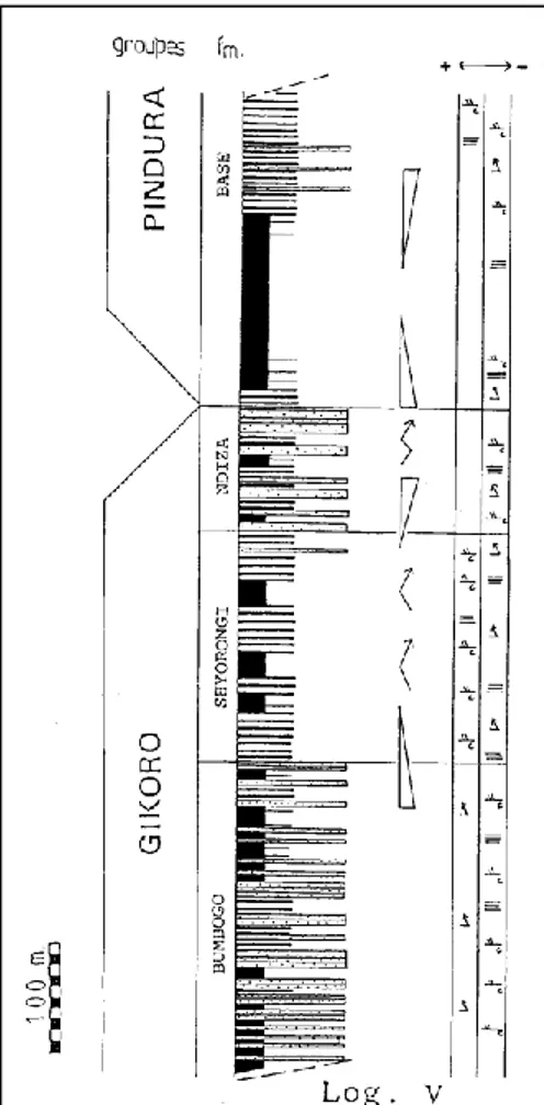
In the centre of the Bumbogo anticline there is the Gitarama granite, which is thought to be related to the mineralisation present (Lehmann et al., 2014). This is surrounded by the Mesoproterozoic Gikoro and Pindura Groups from the Ankanyaru Supergroup. All the metasedimentary rocks of these groups underwent a certain amount of low grade metamorphism (Fernandez-Alonso et al., 2012). The Gikoro Group contains three formations in the Bumbogo anticline. From bottom to top: the Bumbogo, Shyorongi and Ndiza/Nduba Formation (Baudet et al., 1989). The Bumbogo Formation consists of quartzite and decimetric banks of sandstone, sandy siltstones and alternations of sandstone and shale (Baudet et al., 1989). The Shyorongi Formation is made of pelitic rocks, namely argillic shales alternated (not always) with centimetric banks of sandstone (Baudet et al., 1989). The shales can be altered. The Ndiza Formation (western flank anticline) and Nduba Formation (eastern flank anticline) consist of quartzites and sandstones with thicknesses up to four metre, as well as argillic shales layers which can be more sandy in
11 certain areas (Baudet et al., 1989; Theunissen et al., 1991). The Pindura Group has only one formation in the Bumbogo anticline: the Base Formation. This consists of black, graphitic shale layers and alternations of sandstone and shale (Figure 7) (Baudet et al., 1989).
Figure 7: Stratigraphic column for the Bumbogo anticline (western flank) (Baudet et al., 1989)
Several faults cut the Bumbogo anticline both in a N-S and an E-W direction (De Clercq, 2012). Within the anticline multiple higher order folds can be found which determine where mineralisation can occur. This mineralisation occurs in the form of pegmatites and quartz veins (Dewaele et al., 2016). This last deposit type seems to occur in other mines mostly in the shaleous packages at the top of the Bumbogo Formation and partly in the Shyorongi Formation (Dewaele et al., 2016).
As already said the most important tungsten mines line up and because they have similar positions in the stratigraphic column the area in which they are located is called the "Tungsten belt" (De Magnée and Aderca, 1960). This zone stretches from the NW of Kigali towards southern Uganda and has a NNW -SSE orientation. Tungsten mineralisation occurs here in the form of quite thick bedding-parallel and crosscutting quartz veins.
12
4. Geology Bugarama mine: historical studies
Detailed geological mapping of the Bugarama mine has been carried out by De Trey (1957), Wasilewski (1972) and Pohl (1973), which resulted in different views about the origin of the mineralisation.
De Trey (1957) already recognised the presence of a large anticline at Bugarama which has a NW-SE orientation. At that time only three hills were being exploited: Bugarama, Murundi and Fumbwe. These are located in the western part of the concession. De Trey recognised the presence of NE-SW oriented faults between these blocks. The most northern fault, between Murundi and Fumbwe, he identified as a left-lateral strike-slip fault. He recognised three basic lithologies: graphitic shales, quartzite and more sandy shales. There are also more specific lithologies which are less common, being psammites and more sandy quartzite. All of these rocks underwent a certain amount of metamorphism and are thus metasedimentary. According to him the sandy shales are the oldest at the mine and they are found in the centre of the anticlinal stucture at Bugarama. Two quartzite banks can be found: one in the western part of the concession and one in the eastern. He also noted the presence of volcanic rocks that cover parts of the mining concession. The quartz veins are either bedding-parallel or crosscutting, which is less abundant. Mineralised veins mostly occur in more shaleous packages. The tungsten (ferberite) is found in irregular pockets in the quartz veins and is often a replacement of scheelite. The ferberite is also often altered to tungsten oxides.
The same lithologies as De Trey found, were identified by Wasilewski (1972). The same goes for the general structure of the mine, apart from the fact the Wasilewski split up the Murundi hill into the Murundi and Kabindi blocks. He identified three NE-SW oriented faults with the most northern a left-lateral strike-slip fault and the two other right-lateral strike-slip faults. He stated that there were two tectonic phases that had a significant influence. During the first phase the lithologies were folded and the anticlinal structure was formed. In the centre of this the graphitic shales and more sandy shales can be found. During the second phase, after the sediments lithified, both NW-SE and NE-SW oriented faults were formed. The tungsten mineralisation was most likely emplaced during the first phase as the faults cut through the veins and the veins are often folded. Besides quartz the veins can also contain high amounts of muscovite and tourmaline when alteration took place.
Pohl (1973) also recognised an anticlinal structure with the mine located in its eastern flank. The faults between the different hills are according to him right-lateral. He identified the same lithologies and divided them into packages: Kiringo, Bugarama, Kabindi Quartzite and Fumbwe. Kiringo, Bugarama and Fumbwe basically consist of alternations of shales, graphitic shales and more sandy packages. The Kabindi Quartzite is in some places altered in a way it is just a compact sandstone. All of these lithologies underwent metamorphism or a tectonic phase which caused their folding. Most of the quartz veins are
13 located in fractures and are parallel to the stratigraphy. They can be found in all lithologies but the mineralised veins are mostly associated with shales and graphitic shales. Crosscutting veins are less abundant. Different forms of alteration can be found: silification, sericitization and tourmalinization. In a first phase scheelite and massive ferberite formed. Later pseuomorphs of ferberite formed after scheelite. He stated the mineralisation is most likely hydrothermal and epigenetic.
The Bugarama tungsten deposit is located in the eastern flank of a higher order overturned anticline on the Bumbogo anticline. The anticline has a NW-SE orientation with a slight dip towards both the north and the south (De Trey, 1957). The anticlinal structure is estimated to be present until around 500 m below the surface. Below this there are most likely more folded structures as well as the granitic body responsible for the mineralisation (Frisch 1971, 1975; Pohl 1973, 1975). Multiple higher order folds occur and seem to control where the mineralisation is present. Numerous NE-SW oriented faults occur within this anticline and crosscut the different lithological units.
The lithologies at Bugarama are part of the Bumbogo Formation and consist of alternations of sandstones, quartzites, sandy siltstones and graphitic shales (De Trey, 1957, Wasilewski, 1972, Pohl, 1973). All of these underwent a certain amount of greenschist facies metamorphism and deformation that resulted in folding, shearing, boudinage and metamorphism. From bottom to top there is a package of (graphitic) shale and sandy siltstone, a quartzite bank (Rubavu/Kabindi), again (graphitic) shale and sandy siltstone, a quartzite bank (Rubona), again (graphitic) shale and sandy siltstone and on top of this Cenozoic volcanic rocks from the Virunga chain (Figure 8) (De Trey, 1957, Wasilewski, 1972, Pohl 1973). According to Pohl (1973), the aforementioned quartzite banks are in fact one and the same quartzite.
Within the Bugarama mine five main blocks for exploitation are present. In the eastern part the Rubona block and in the western part from south to north the Bugarama, Kabindi, Murundi and Fumbwe blocks. These last four are separated from each other by three NE-SW oriented faults. The most northern one is most likely a left-lateral strike-slip fault and the two southern ones right-lateral strike-slip faults (De Trey, 1957, Wasilewski, 1972).
Tungsten mineralisation can be found, as everywhere in the Tungsten belt, within hydrothermal quartz veins. At Bugarama mine different types of quartz veins are identified. They have different lengths and are not continuous throughout the mine. Smaller discordant veins can be found as well as longer (20 - 40 km)
Figure 8: Simplified lithostratgraphy at Bugarama
14 veins which are parallel to each other. According to different previous studies, there is an estimated reserve of 1200 tonnes wolframite which is spread and disseminated throughout the veins. The tungsten mineralisation is spread over an area of about 3 km² with the richest veins in the Bugarama block. Besides tungsten the quartz veins are described also to contain reinite, which is a pseudomorph of ferberite, scheelite, muscovite, tourmaline, kaolinite and occasionally cassiterite or pyrite (Pohl, 1973, 1976). Around some mineralised quartz veins, a tourmalinization halo can be observed. This is an indication for alteration that was contemporaneous with the mineralisation itself (Pohl, 1973, 1976).
It has been proposed that the different deposits in the Tungsten belt and even in a wider region formed during similar mineralisation phases (Pohl, 1976). During a first stage there was tourmalinization, sericitization and silification of the host-rocks. This was accompanied with the crystallisation of larger crystals of muscovite/sericite, ferberite, scheelite and quartz. This mineralisation phase is interpreted to have occurred partly during a deformation phase since part of the quartz veins are folded and deformed. During a second stage of mineralisation there were hydrothermal fluids causing the formation of ferberite pseudomorphs after scheelite and the kaolinitisation of feldspars (Pohl, 1973).
15
Tungsten mineralisation
1. General
Tungsten does not occur as a free metal, but is incorporated in 45 different minerals (British Geological Survey, 2011; Hess, 1917). The monotungstates are the most important minerals that contain tungsten and it are these minerals that are exploited (British Geological Survey, 2011). The monotungstates with an increasing percentage of tungsten are the following (British Geological Survey, 2011; Hess, 1917): Stolzite (PbWO4; 50,9% WO3), Ferberite (FeWO4; 50,9% WO3), Wolframite ((Fe,Mn)WO4; 76,5% WO3), Hübnerite
(MnWO4; 76,6% WO3) and Scheelite (CaWO4; 80,6% WO3). The term wolframite is mainly used for the
intermediate 20-80% between the ferberite and hübnerite end-members, so it is in fact a solid solution (Hess, 1917). Of these five minerals scheelite is by far the most abundant and is found in approximately 2/3 of all known deposits (British Geological Survey, 2011). Only scheelite and wolframite are of economic importance, because the other minerals aren’t as common in nature (Dvořáček et al., 2017).
Primary tungsten deposits are always associated with granitoid rocks or in a lesser extent with medium- to high-grade metamorphosed rocks (British Geological Survey, 2011). The exact relation between fluids originating from the granitoids and the tungsten deposits themselves is not yet clear (Hulsbosch et al., 2016). There is still debate about whether the intrusions provided the mineralising fluids themselves or if they were just a source of heat that created the conditions for the circulation of hydrothermal fluids (De Clercq, 2012). What is known is that tungsten deposits are usually characterized by a certain degree of hydrothermal alteration. This alteration is most commonly one of the following or a combination of them: tourmalinization, silification and sericitization/muscovitization (Dewaele et al., 2016; Pohl, 1973). The deposits are mostly located in or close to orogenic belts. The majority of tungsten deposits, although not exclusively, was formed during the Mesozoic (British Geological Survey, 2011). Primary tungsten deposits are spread all over the world. The biggest deposits can be found in China, Russia, Canada, Kazakhstan and the United Kingdom. In the European Union the biggest deposits can be found in the United Kingdom (Cornwall), Austria, Portugal and Spain (British Geological Survey, 2011). Many other countries across the world have tungsten deposits, but many of these are not interesting economically speaking. This can be due to their limited size or their inaccessibility.
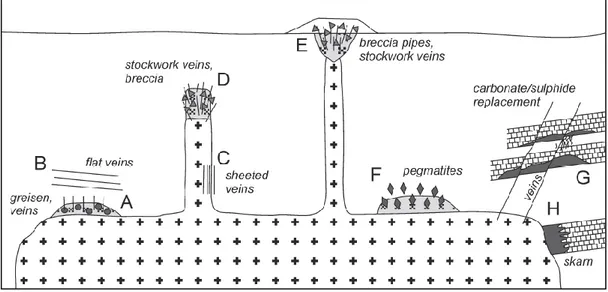
There are five main types of tungsten deposits which are of economic importance (British Geological Survey, 2011; Hess, 1917): vein/stockwork deposits, skarn deposits, breccia deposits, porphyry deposits and greisen or disseminated deposits (Figure 9). Besides these five there are some smaller, less common deposit types which are usually not exploited: pegmatite, stratabound, placer, brine/evaporite and hot spring deposits. Often different deposit types are combined and exist together. Which type of deposit will
16 form is depending on the geological setting, the evolution of the mineralising fluids and the structural features and lithology in an area (Roberts et al., 1998). At Bugarama mine as well as in Rwanda itself quartz vein-type deposits are the most common. Therefore, these will thus be discussed in more detail.
Figure 9: Overview of the granite-related primary tungsten deposit types (De Clercq, 2012)
Quartz vein mineralisation
Vein or stockwork deposits are deposits in which the orientation of the veins is either structurally controlled or random (British Geological Survey, 2011; Hess, 1917). They can be formed in some different ways. Mostly it is by filling of veins and cracks when a fluid percolates through them and crystallizes to form these veins (British Geological Survey, 2011). Another way is that there were already veins present and that they recrystallize due to metamorphism. These type of deposits are often associated with granitic intrusions (British Geological Survey, 2011). The main constituent of the veins is usually quartz. There are simple deposits with only quartz and tungsten (mainly wolframite and scheelite), but in more complex cases up to 50 different minerals can be present (British Geological Survey, 2011). Often other valuable metals like copper, tin and gold are present (British Geological Survey, 2011; Hess, 1917).
The complexity of the deposit can vary from locality to locality. In some places simple quartz veins are present that are not interlinked (lode-type). Stringer-type deposits have multiple sheeted, closely spaced quartz veins which are parallel (British Geological Survey, 2011). The most complex form is a stockwork deposit where multiple (sub)parallel quartz veins are interlinked by smaller veinlets (Hess, 1917). Often these different vein types can be formed in different stages, starting with the original parallel veins which are then later crossed by a new generation of veins. Usually the mineralisation formed in different stages (paragenesis), starting with the silicate-tungstates and ending with the carbonates (Hess, 1917).
17
2. Rwanda
Numerous quartz veins mineralised in tungsten and tin occur in the Karagwe-Ankole belt. Tungsten, tin, niobium and tantalum mineralisation all occur nearby fractionated peraluminous leucogranites (Hulsbosch et al., 2019). However Sn and W deposits are usually not spatially related to each other. In Rwanda primary tungsten deposits are dominantly associated with hydrothermal quartz veins, although small quantities may also be found dessiminated in the host-rock (Goldmann et al., 2013). Tungsten deposits in Rwanda are divided into three groups based on their geographic distribution: a western, central and eastern zone (Dewaele et al., 2016). The Bugarama deposit, as well as the equally important Gifurwe and Nyakabingo deposits, are located in the central zone (Dewaele et al., 2016), and form the so-called Tungsten belt of Aderca (De Magnée and Aderca, 1960). All the major tungsten mines in this Tungsten belt are aligned in a NNW-SSE direction. The emplacement of tungsten mineralisation is controlled both lithologically and structurally. In Rwanda the most common tungsten mineral is the iron-rich variant of wolframite, being ferberite. The ferberite has been identified as reinite which is pseudomorph of ferberite after scheelite (Goldmann et al., 2013). The tungsten deposits in Rwanda are less economically interesting, because of their smaller scale and their brittle appearance.
Host-rocks for the tungsten mineralised quartz veins are sequences of quartzites (rare), sandstones, sandy siltstones and (graphitic) shales (Dewaele et al., 2016; Goldmann et al., 2013). The graphitic shales, rich in organic material, may have been important for the precipitation of tungsten as they could have been a reactive front (Dewaele et al., 2016). When fluids containing the tungsten entered the graphitic rich sediments the following reaction took place that caused the pH to rise (Wood and Samson 2000):
with M = (Fe,Mn)2+ or Ca2+ and n = 0 to 2
This then caused the precipitation of scheelite and ferberite (Goldmann et al., 2013, Dewaele et al., 2016). The veins occur in the centre and on the flanks of second-order anticlines on the Bumbogo anticlinorium. The geology is even more complicated by numerous faults that cut through the rocks at various angles and positions (Baudet et al., 1989).
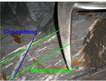
In Rwanda three generations of tungsten mineralised quartz veins are generally observed (Dewaele et al., 2016; Goldmann et al., 2013). A first generation consists of small, often folded, bedding-parallel veins. They have a thickness of in general less than 5 centimetres. These are usually found in shales and graphitic shales. The quartz is usually blocky or fibrous. Iron oxides can often been found within fractures. Muscovite on the other hand is quite rare. They never contain any mineralisation, but an alteration zone of a few centimetres can be found around them. This alteration consists of silicification, tourmalinization,
18 muscovitization and precipitation of biotite (Dewaele et al., 2016). The second generation consists of thick (up to several metres), bedding-parallel quartz veins (Dewaele et al., 2016). They can be folded, but features indicating boudinage can be present as well. Quartz is forming the main component of these veins, but they can also have a substantial amount of muscovite present. They are usually associated with graphitic shales, which are themselves located in a shale or sandy siltstone package. Parts of the host-rock can be found as inclusions at the edges of these veins. Tungsten mineralisation in the form of wolframite can be present. The mineralisation is dominantly present in fractures which means its formation happened after the emplacement of the quartz vein. The third generation consists of veins that crosscut the stratigraphy and the first and second generation quartz veins (Dewaele et al., 2016). They can also be up to several metres thick and are hosted by most of the lithologies present. Their mineralogy is the same as the second generation of veins, which implies that they can also contain wolframite mineralisation.
The first generation veins are interpreted to have been formed during an early phase of deformation, possibly by a crack-seal mechanism which can be characterised by host-rock inclusion bands, stretched crystals and fibrous crystals (Dewaele et al., 2016; Virgo et al., 2014). The bedding-parallel quartz veins have intruded cleavage planes sub-parallel to S0. These veins have been interpreted to have been formed during or in a late stage of a compressional deformation event, which is thought to be related to the intrusion of the G4-granites (Dewaele et al., 2016). The W-mineralised crosscutting veins are interpreted to have also been formed in a late stage of a deformation event, possibly overlapping in time with the formation of the W-mineralised bedding-parallel veins (Dewaele et al., 2016). The crosscutting quartz veins formed by opening of pre-existing planar structures (cleavage planes, axial planes, joints ...), some of which were connected to form important pathways for the mineralising fluid (Dewaele et al., 2016).
The G4-granites were dated at 986±10 Ma which corresponds within error with the age of tungsten mineralisation, dated of 992.4±1.5 Ma. This overlap in age has been interpreted as proof for the direct relationship between these granites and the emplacement of the tungsten mineralisation (Dewaele et al., 2016). Some other muscovite samples of vein-type and pegmatite-type tungsten mineralisation were however dated to around 960 Ma, which is significantly younger than 990 Ma (Dewaele et al., 2016). This might be explained by the fact that hydrothermal systems that are responsible for the formation of ores, stay active during a longer period of time after the emplacement of the granites (Zhao et al., 2004). Other possible explanations might be: the 960 Ma date corresponds to (1) the age of the muscovite precipitation (2) the time when the temperature dropped below the closing temperature of muscovite (3) the period of recrystallisation of musovite (Dewaele et al., 2016).
Two different stages have been identified in the paragenesis of tungsten mineralisation in Rwanda (Goldmann et al., 2013). In a first phase, scheelite and wolframite were formed as primary minerals. In the second phase, changing physical and chemical conditions caused the formation of ferberite
19 pseudomorphs due to recrystallization of the earlier formed scheelite (Goldmann et al., 2013). The exact timing of the formation of the pseudomorphs has not yet been determined. However, these minerals are only formed quite late in the growth and evolution of the different quartz veins. Remnants of scheelite can still be found in the wolframite mineralisation. In addition to these two stages, a sulfide phase is also often identified (Dewaele et al., 2016; Goldmann et al., 2013). During this phase sulfide minerals like galena and chalcopyrite precipitated. A later generation of ferberite could replace the primary ferberite during this phase as well. It can be recognised by its more skeletal structure. The most common secondary tungstates are ferritungstite, anthoinite, alumotungstite, cerotungstite, meymacite, raspite, and different Fe-oxides. These minerals occur quite late in the evolution of the quartz veins and can be present in fractures that were generated after all the quartz precipitated (De Magnée and Aderca 1960; Dewaele et al., 2016).
The main tungsten mineralisations that have been studied in detail in Rwanda are Nyakabingo (De Clercq, 2012; Dewaele et al., 2016; Pohl, 1994) and Gifurwe (De Clercq, 2012; Frisch, 1975)
2.1. Gifurwe
Gifurwe tungsten mine is located approximately 50 km NW of Kigali and approximately 20 km SE of Bugarama. The tungsten deposit is located in the northern flank of the Bumbogo anticline (Frisch, 1975). It is positioned in the core of an anticline. This higher order anticline has a domal structure with a plunge towards the NW and the SE (Frisch, 1975). Several other higher order folds as well as numerous faults are present across the area.
The following lithologies host the tungsten mineralisation: sandstones/quartzites and metapelitic units, mostly shales (Frisch, 1975). The mineralisation itself is associated with quartz veins but can also be found scattered in the surrounding host-rocks. Unlike the general three quartz vein generations in Rwanda the small, bedding-parallel and often folded veins (first generation) are absent at Gifurwe (Frisch, 1975). So the first quartz vein generation found consists of the thick, bedding-parallel veins. These generally have thicknesses between 10 and 40 cm, which can exceptionally be up to two metres. These can occasionally be folded and boudinaged. The mineralisation in these veins is usually less abundant than in the crosscutting veins at Gifurwe (Frisch, 1975). The crosscutting quartz veins (second generation) cut through the stratigraphy and the previous vein generation. It has been observed that these veins can turn to a bedding-parallel position. This is however rare (Frisch, 1975). The crosscutting veins can contain tungsten and if so they are usually more mineralised than the bedding-parallel ones. The tungsten in both of these two vein generations can be present as small or large aggregates and scattered throughout the veins, but the contact zone with the host-rock is often the richest area (Frisch, 1975).
20
2.2. Nyakabingo
Nyakabingo tungsten mine is located approximately 15 km NW of Kigali and approximately 55 km SE of Bugarama. The deposit is located in a secondary anticline between the Bumbogo anticline to the west and the Yanza syncline to the east (Dewaele et al., 2016). The anticline itself plunges to the north and does not have a domal structure. It is crosscut by several N-S and E-W oriented faults. Numerous higher order folds, synclines and anticlines are present (Dewaele et al., 2016).
The host-rocks for the quartz veins are sandstones/quartzites and metapelitic sediments, which are mostly shales. At Nyakabingo, three types of quartz veins have been observed: (1) small, often folded bedding-parallel veins which do not contain W-mineralisation, (2) thick, bedding-bedding-parallel quartz veins and (3) crosscutting quartz veins (De Clercq, 2012; Dewaele et al., 2016). The small, folded bedding-parallel quartz veins never contain mineralisation. They are interpreted to have been formed by a crack-seal mechanism. The thick, bedding-parallel and crosscutting quartz veins can contain tungsten mineralisation. The thick W-mineralised bedding-parallel quartz veins are also typically hosted by dark shales, where they intruded bedding-parallel cleavage planes. Both types of bedding-parallel veins are often crosscut by subvertical veins, which are at high angle to bedding (Dewaele et al., 2016). The crosscutting quartz veins have been interpreted to be formed by opening of pre-existing planar structures (cleavage planes, axial planes, joints, ...), some of which were connected to form important pathways for the mineralising fluids to travel through. After their formation, all quartz veins have been crosscut by numerous faults (Dewaele et al., 2016).
21
Material and methods
1. Fieldwork
The Bugarama tungsten mine has been subdivided by the New Bugarama Mining company into five blocks that are separated from each other by faults (Pohl, 1973; Wasilewski, 1972). These different blocks each physically consist of a hill. In the eastern part, there is the Rubona block and in the western part from south to north: the Bugarama, Kabindi, Murundi and Fumbwe blocks. Several other hills lie within the mining concession, the most important ones being Rusagara to the west, and Sozi to the northeast. These hill are, however, currently not exploited. The mineralised quartz veins are exploited in underground galleries in the different blocks. There is an entrance gallery (the so-called bouveaus) penetrating the hills perpendicular on the bedding. These have a SW-NE orientation in the western blocks and a SE-NW orientation in the Rubona block in order to cut through the veins and make second order galleries parallel to them. Once mineralised veins have been reached, they are followed by galleries (to so-called “chassages”). In total eight galleries were investigated during the fieldwork: two in the Bugarama block, one in the Kabindi block, one in the Murundi block, two in the Fumbwe block and two in the Rubona block (Figure 10). Observations were not always straightforward as dust from blasting inside the galleries formed a small layer on the sides of the walls. Also terrain observation have been made where possible, but this is complicated due to lacking outcrop and the presence of mining tailings.A less detailed description of the Rusagara and Sozi hill was also included. Strike and dip measurements were taken with a geological compass. A detailed description of the different galleries and the terrain can be found in Appendix A. In total 40 samples were collected (Figure 11) The sample list can be found in Appendix B.
22
23
24
2. Petrography
In total 20 out of 40 samples were selected for microscopic investigation. Petrography was carried out on these 20 thin sections to characterize the different lithologies as well as to identify different minerals present that might be important for the construction of the paragenetic sequence. A LV100 Pol Led microscope with a Nikon DS-Fi3 Microscope Camera (Nikon Corporation) were used for the study at magnifications between 4x and 100x. The pictures were taken with the attached camera and processed with the Nikon NISElements Advanced Research (AR) software package.
25
Results
1. Fieldwork
1.1. Description galleries and outcrop
See figure 10 for an overview of the locations of the different galleries and outcrops.
1.1.1. Bugarama
In the Bugarama block two main galleries (B23 and B60) have been investigated. According to the mining company, these contain the richest tungsten mineralised quartz veins, currently known in the concession. A large section of outcrop along a road that lies on the Bugarama block was also mapped.
B23
Gallery B23 is located in the Bugarama block and has a SW-NE orientation. The first 137,85 m of the gallery has been mapped. Although this is not the entire length of the gallery, this section is considered as sufficient to get a general insight in the stratigraphy and the occurrence of mineralisation in this gallery. In total six samples were taken (SDS 2019-01, SDS 2019-02, SDS 2019-03, SDS 2019-04, SDS 2019-05 and SDS 2019-06). The overall strike and dip in B23 is N50W/70S, with some deviations from this at certain locations (see Appendix A).
The first 20 m starting from the entrance of the tunnel consists of an alternation between blue-greyish sandstone and shale layers. The sandstone is finely grained and occurs in banks that have thicknesses between 30 cm to a few metres. The sandstone also contains quite a lot of mica's, mostly muscovite, spread throughout the rock. There are only two quartz veins present in this zone. They crosscut the stratigraphy, have a thickness of a few centimetres and contain muscovite. The following five metres (19,65 m - 25,95 m) consists of a dominantly shaleous package which contains a large amount of small crosscutting and bedding-parallel veins. In addition, there occur quartz lenses and a bigger, parallel, sacharoidal quartz vein. After this five metres of shale, a metre wide bank of sandstone containing three veins, is present. Until 30,35 m, there is an alternation of shale and sandstone, which is in some places recrystallized to a quartzite. The next 15 m (30,35 m - 44,95 m) contain sandstone layers, but most striking are the two big shale packages (31,25 m - 36,25 m and 36,85 m - 44,95 m) that contain plenty of different generations of quartz veins. These veins are all a few centimetres in thickness and bedding-parallel. In addition to this, indications for brecciating and shearing have been identified in the form of broken up layers
26 and small fractures. From 44,95 m until 55,05 m, there is an alternation between banks of shale and sandstone, where the latter is occasionally recrystallised to a quartzite. These have thicknesses between 0,50 to 1 metre. All of these contain some smaller quartz veins which mostly crosscut the layering. From 55,05 m onwards, small layers of graphitic shale
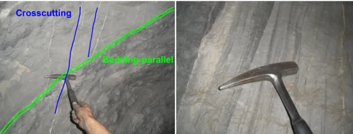
are observed that occur isolated between the different sandstone and shale layers. This graphitic shale contains some weathered white minerals. The sandy packages have thicknesses up to two metres while the graphitic shale and the shale layers have thicknesses between 0,50 and 1 metre. A few different types of quartz veins are present (see Appendix A), amongst them the small bedding-parallel veins and the crosscutting veins as seen in figure 12.
At 71,75 m, there is a significant change in lithology. From there on all the sandstone is slightly or completely recrystallised to quartzite. Quartz veins with a width of mostly less than one metre occur between the metric quartzite banks. These veins usually have two types of quartz present: fragments of big, clear, translucent quartz crystals in a matrix of smaller, fine grained quartz. This quartzite bank ends around 120,85 m. Three samples have been collected from this section: one sample of a quartz vein with the two types of quartz (SDS 2019-03) and two samples of the quartzite (SDS 2019-01 and SDS 2019-02). From 120,85 m onwards, we observe banks of sandstone alternated with shale and (mostly) bedding-parallel quartz veins (Figure 13). Three of these veins (around 125 m, 132 m and 136 m) contain tungsten mineralisation and were exploited at the time of the fieldwork. They produce consecutively 50, 100 and 70 kg raw tungsten ore per day. The exploited zones are located between sandstone packages and consist in fact of bedding-parallel quartz veins of maximum 20 cm thick. In these zones there is also graphitic
Figure 12: Bedding-parallel and crosscutting veins in sandy host-rock (70 m from entrance B23)
Figure 13: Parallel quartz veins with signs of boudinage and folding (131,50 m from entrance B23)
Figure 14: Folding and boudinage of a quartz vein (137,50 m from entrance B23)
27 shale present between the veins as well as tourmaline and muscovite crystals which are a sign of alteration. The exploited shafts are perpendicular to the main tunnel B23. Boudinage and disturbance of the parallelity of the layers is present in some areas (Figure 14), often in a zone of no more than one metre thick. These boudinaged layers are still parallel to the original bedding. Two samples of the exploitation zones and the surrounding rock were collected (SDS 2019-05 and SDS 2019-06), as well as one sandstone specimen (SDS 2019-04).
B60
The total length of 173,85 m was investigated during the fieldwork. The gallery has a SW-NE orientation. The overall strike and dip in B60 is around N50W/70S, similar to B23. In total two samples were collected (SDS 2019-07 and SDS 2019-08).
The first 15 m of tunnel B60 (Bugarama block) consist of weathered, metasedimentary rock, which made it difficult to identify the original rocks. Until 49,30 m, there is an alternation of banks of shale, sandy siltstone and sandstone packages. In the beginning the banks of sandstone can be up to several metres thick, but usually they have a decimetric scale. Between 24,70 m and 37,40 m some quartz veins are located which have a limited width and crosscut the stratigraphy. Some larger (centimetric scale) bedding-parallel quartz veins are also present (Figure 15). In the shale layer from 24,70 m to 27,60 m some darker layers (Figure 16), are noted. Sedimentary structures like parallel laminations can also be identified.
Figure 15: A bedding-parallel quartz vein crosscut by several smaller quartz veins (25 m from entrance B60)
Figure 16: Darker layers within a shale package (27 m from entrance B60)
28 From 49,30 m onward the relative amount of veins increases and most of them contain the two types of quartz, as mentioned above, but no mineralisation. Besides a few faults and fracture zones (orientation N20W/70S), also intersection lineation is present in the shale layers. At 65,30 m the start of the quartzite is identified. Until 156,60 m, there is the regional alternation of dominantly quartzite present with quartz veins every few metres. Most of these veins contain again the two types of quartz as well as some fragments of the neighbouring rocks. Some quartzite layers
appear less solid than others and could perhaps be identified as a sandstone. This has been mostly observed in the first half of this package. Thin layers (few centimetres) of graphitic shale are present in-between some of the quartzite banks (Figure 17) In this zone one sample of the quartzite was collected (SDS 2019-08).
Until the end of the tunnel at 173,85 m, there is an alternation between banks of shaleous and sandstone layers, which are both centimetric or decimetric in thickness, and some quartz veins. Two exploited zones can be found here, one around 157 m and one around 164 m. They both contain several quartz veins parallel to the bedding, as well as layers of graphitic shale. According to the mining company, the first shaft has an average tungsten production of half a kilogram per day, while the second one delivers four kilogram per day. A sample was collected from the last excavated quartz vein along with part of the neighbouring alteration recognised by a difference in colour (SDS 2019-07).
Bugarama outcrop
A part of the outcrop from the Bugarama block was mapped along the road leading from the house towards Lake Burera. The section is not complete due to weathering and burial by overlying more recent cover. The total length of the Bugarama outcrop that was mapped is 104,10 m and consists of three separate sections. GPS coordinates were noted at the start and end of each section (See Appendix A).
The first 22,80 m of the first section consists of a regular alternation of shale and sandstone banks, which occur on a metric scale. Two colours of sandstone are present: white and more bluish. A fault could be identified at 15,40 m due to an interruption of the continuity of the layers. In this section only one quartz vein has been identified. This vein is unmineralised and occurs parallel to the bedding in sandstones. A sandstone bank of five metres thick (25,80 m - 30,80 m) is followed by a shaleous package with a total thickness of 15 m. In the sandstone banks, some diaclazes (N60W/80S, N60E/40S, N60E/50S) can be
Figure 17 : Graphitic shale (black) between quartz veins (157 m from entrance B60)
29 observed. The strike and dip in this section is around N40W/50S, but the dip increases slightly towards the next section.
The second section, with a total length of 35 m, contains mostly banks of sandstone and shale layers, with an occasional unmineralised quartz vein. Two of these veins contain the two types of quartz: clear, big quartz and fine grained quartz. When a vein has been identified, graphitic shale is usually present. The strike and dip her have an average of N80W/40S. In the third and last section (23,30 m) of this Bugarama outcrop there is the same alternation of sandstone and shale present with some quartz veins and sandy siltstone.
1.1.2. Kabindi
I26
Tunnel I26 is the only tunnel of the Kabindi block that has been mapped during this fieldwork. This tunnel has a SW-NE orientation. Five samples were collected in I26 (SDS 2019-12, SDS 2019-13, SDS 2019-14, SDS 2019-35 and SDS 2019-36). The overall strike and dip are consistent with the southern Bugarama galleries, with an average value of N40W/70S, although also higher dip values of 80 to 90 degrees south were measured. These might be different cleavage planes based on the different dip angles measured.
The first 32,50 m of the tunnel is made up of banks that mostly consist of shaleous layers, with some quartz veins. The banks of shale can reach thicknesses of around a metre, but are mostly decimetric. Some small sandstone banks of 10 cm thick are present, but these occur only seldom. The veins mostly consist of small crystals with some muscovite and are parallel to the bedding, although some smaller crosscutting veins are present as well. The latter cut the stratigraphy at higher angles. A lot of folding is present in different orientations, both in the shale layers as in the veins (Figure 18 and 19). Three veins are exploited for tungsten in Tunnel 126: at 4,50 m (2 kg/day), 17,50 m (6 kg/day) and 24 m (15 kg/day). The last two consist of several smaller quartz veins together, separated by shaleous rocks. The mineralisation seems to be lost when exploiting deeper. Two samples were taken from the veins and of the surrounding rock (SDS 2019-12 and SDS 2019-13).
30 From 32,50 m until the start of the quartzite around 50 m, we find more banks consisting of sandstone and sandy siltstone layers. A lot of quartz veins are present, but the average thickness is significantly less compared to the previous part of the tunnel. Some veins and layers are folded and boudinage also occurs in some places. Despite this, all these layers and veins are still parallel to each other. The smaller veins consist of more sugary quartz, while the large quartz veins have bigger quartz crystals. One 30 cm thick vein (around 46 m) is exploited with an average daily production of 15 kilogram tungsten per day. A sample was taken of sandstone/sandy siltstone
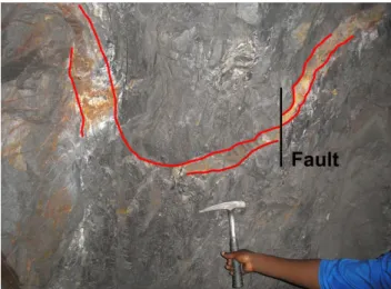
near a non-productive vein (SDS 2019-35). As said before the quartzite starts around 50 m and continues up until 96,20 m where there is a disturbed zone. Folding and a vertical fault can be identified (Figure 20) in this small shear zone. As to be expected, this part consists mostly of quartzite, but some sandstone layers are still present. Some quartz veins are present, but they are difficult to distinguish in the quartzitic rocks. A quartzite sample was collected (SDS 2019-14).
From the end of the quartzite until somewhere around 118,30 m, there is again an alternation between banks of sandstone/sandy siltstone and shale layers, with still a substantial amount of quartz veins. There are both parallel and crosscutting veins with the two different types of quartz. Some of these are folded and/or exhibit boudinage. One major vein (around 100 m), which is almost two metres wide and consists of big quartz crystals, is exploited with an average production of 150 to 200 kilogram of tungsten per day. A sample of the surrounding rock was collected (SDS 2019-36). A smaller vein around 111 m used to have a
Figure 18: Folded quartz vein (15,80 m from entrance I26) Figure 19: Folded shale layers and quartz veins (26,30 m from entrance I26)
Figure 20: Folding of a quartz vein as well as a small fault through the vein (96 m from entrance I26)