Report 607300015/2010
J. Spijker | R. Lieste | M. Zijp | T. de Nijs
Conceptual models for the Water
Framework Directive and the
Groundwater Directive
RIVM Report 607300015/2010
Conceptual models for the Water Framework Directive
and the Groundwater Directive
RIVM, Postbus 1, 3720 BA Bilthoven, Tel 030-2749111, http://www.rivm.nl/ J. Spijker R. Lieste M. Zijp T. de Nijs Contact: Ton de Nijs Ton.de.nijs@rivm.nl
Laboratory for Ecological Risk Assessment
This study was carried out on behalf of the Ministry of Housing, Spatial Planning and the Environment within the framework of project M/607300: Supporting the Groundwater Directive
© RIVM 2010
Parts of this publication may be copied as long as the source is stated: 'National Institute for Public Health and the Environment (RIVM), the title of the publication and the year of publication'.
Abstract
Conceptual models for the Water Framework Directive and Groundwater Directive
There is no single definition of conceptual models in the Water Framework Directive, Groundwater Directive or guidance documents, which are needed to execute the directives. This is shown in a study of the National Institute for Public Health and the Environment in which an inventory was made of the usage of conceptual models. The study also shows the poor availability of existing conceptual models. Therefore, this study recommends collecting conceptual models and compiling these into a single source of knowledge. Research scientists of several disciplines can use this source of knowledge as a basis for their conceptual models. A single source of knowledge also facilitates the mutual consistency and archiving of the individual conceptual models. This source of knowledge should also be available for policy makers.
In this study the following subdivision of conceptual models is proposed: fundamental scientific models, geohydrological models and models aimed at the interdisciplinary communication between science and policy. From this inventory it is shown that the conceptual models which are used in the Netherlands are in general geared towards interdisciplinary communication. The conceptual models mentioned in the guidance documents are equally distributed between geohydrological and
interdisciplinary conceptual models.
A conceptual model is a simplified representation of a groundwater system. A characteristic of a conceptual model is that it contains a map, a schematic profile of the subsurface, an indication of relevant processes and an explanatory text.
In the Netherlands a ‘draaiboek monitoring’ (guidance monitoring) is drafted which describes a cyclic monitoring sequence. On several occasions in this sequence a conceptual model is needed, but in the current situation these conceptual models can differ between these steps of the monitoring sequence. The source of knowledge should contribute to the consistency of the conceptual models in the monitoring sequence.
Key words: conceptual models, groundwater research, Groundwater Daughter Directive, Water Framework Directive
Rapport in het kort
Conceptuele modellen voor de Kaderrichtlijn Water en de Grondwaterrichtlijn De Europese Kaderrichtlijn Water (KRW), de Grondwaterrichtlijn (GWR) en bijbehorende richtsnoeren bevatten geen eenduidige definitie van conceptuele modellen, die nodig zijn om de richtlijnen uit te voeren. Dit blijkt uit onderzoek van het RIVM, waarin het gebruik van conceptuele modellen is geïnventariseerd. Daarnaast blijkt uit het onderzoek dat de gebruikte conceptuele modellen niet goed zijn ontsloten. Daarom wordt aanbevolen om de afzonderlijke conceptuele modellen te verzamelen en samen te voegen tot één kennisbron. Onderzoekers uit verschillende disciplines kunnen daaruit putten en er hun conceptuele modellen op baseren. Een enkele kennisbron helpt ook bij het onderling afstemmen en archiveren van de verschillende conceptuele modellen. De kennisbron moet ook beschikbaar zijn voor beleidsmakers.
In het onderzoek wordt de volgende onderverdeling van conceptuele modellen voorgesteld:
fundamenteel wetenschappelijke modellen, geohydrologische conceptuele modellen en conceptuele modellen gericht op communicatie tussen de verschillende disciplines in wetenschap en beleid. Uit de inventarisatie van conceptuele modellen die in Nederland worden gebruikt voor
grondwatervraagstukken bleek dat ze voornamelijk zijn gericht op de genoemde interdisciplinaire communicatie. De in de richtsnoeren genoemde modellen laten een evenredige verdeling zien tussen geohydrologische en interdisciplinaire conceptuele modellen.
Een conceptueel model is een versimpelde weergave van de werkelijkheid, in dit geval van het (grond)watersysteem. Het bestaat meestal uit een kaartje, een schematische doorsnede van de ondergrond, een indicatie van de relevante processen en een toelichtend verhaal van het (grond)watersysteem.
In Nederland is voor de uitvoering van de KRW een draaiboek monitoring opgesteld waarin een monitoringcyclus wordt beschreven. Binnen deze cyclus is op diverse momenten een conceptueel model nodig. Momenteel kunnen op de diverse momenten in de monitoringcyclus verschillende conceptuele modellen worden gebruikt. De kennisbron moet bijdragen aan de consistentie van de conceptuele modellen in deze monitoringcyclus.
Trefwoorden: conceptuele modellen, grondwateronderzoek, Dochterrichtlijn Grondwater, Kaderrichtlijn Water
Preface
This report is a translation of the Dutch RIVM Report 607300010 'Conceptuele modellen voor de Kaderrichtlijn water en de Grondwaterrichtlijn'. A copy of this Dutch report can be found at the website of the RIVM: http://www.rivm.nl/bibliotheek/rapporten/607300010.html.
Some figures in this report contain labels or descriptions in Dutch. Where relevant, a translation table for these Dutch labels and descriptions are given after the figure.
Compared to the original Dutch report, this report contains some minor editorial changes to clarify the translated text.
Contents
Summary 11
1 Introduction 13
1.1 Overview 13
2 Conceptual models and the Water Framework Directive 15
2.1 Introduction 15
2.2 Summary and conclusions from the EU guidance documents 16 2.2.1 Overview of relevant guidance documents for groundwater 16 2.2.2 The definition of a conceptual model in EU guidance documents 16
2.3 The development and use of conceptual models 17
2.4 Information about conceptual models per guidance document 18 2.4.1 Guidance document about Pressures and Impacts (no. 3) 19
2.4.2 Guidance document about Monitoring (no. 7) 19
2.4.3 Guidance document about Groundwater Monitoring (no. 15) 21 2.4.4 Guidance document about Prevent and Limit (no. 17) 23 2.4.5 Guidance document about status assessment (Status and
Trend Assessment) 23
3 Definitions of conceptual models 25
3.1 General 25
3.2 The conceptual model: fundamental approach 25
3.3 The conceptual model, geohydrological approach 27
3.4 The conceptual model as an instrument for knowledge exchange
between disciplines 30
3.5 How is the term conceptual model used in the guidance
documents? 31
3.6 Summary 33
4 Examples of conceptual models 35
4.1 The answering of the ‘water balance question' 35
4.2 Large-scale groundwater pollution near Apeldoorn 35 4.3 The freshwater-saline water boundary in the Netherlands 37
4.4 Influence of groundwater on surface water 40
4.5 Influence of groundwater on the terrestrial ecosystem 42 4.6 The local case study: Bank infiltration Bergambacht 43
4.7 Conclusions 46
5 Building blocks for conceptual models 47
5.1 Pressures and Impacts 47
5.2 Monitoring 47
5.3 Preventing and Limiting 48
5.4 Status and Trend Assessment 48
5.4.1 Freshwater-saline water boundary 48
5.4.2 Aquatic ecosystems 48
5.4.3 Terrestrial ecosystems 48
5.4.4 Drinking water 49
6 Conclusions and recommendations 51
6.1 Conclusions 51
6.2 Recommendations 51
References 55
Summary
The new Groundwater Directive (GWD, Directive 2006/118/EC) and the various European guidance documents state that conceptual models must be used during the implementation of the Water Framework Directive (Directive 2000/60/EC).
To satisfy the demand for conceptual models in the Netherlands the Ministry of Housing, Spatial Planning and the Environment (VROM) asked the National Institute for Public Health and the
Environment (RIVM) to make an inventory of what we should understand the term conceptual models to mean and which conceptual models are available in the Netherlands.
The definitions of conceptual models in the Groundwater Directive seem to be more or less the same but do not appear to be derived from a single basic definition. Although in the guidance documents a conceptual model can describe a problem area in qualitative terms, these qualitative terms are also completed quantitatively. Sometimes there even appears to be an operational/mathematical model. Furthermore, the guidance documents reveal that a conceptual model should be part of the
characterisation of a groundwater body but that the complexity of the model can vary, depending on the situation.
Conceptual models can be subdivided into purely scientific/abstract models, geohydrological
conceptual models and conceptual models focused on the communication between different disciplines in science and policy. The nature of the conceptual models in the inventory reveals that these are predominantly targeted at the aforementioned interdisciplinary communication. The models stated in the guidance documents can be more or less equally split between geohydrological and
interdisciplinary conceptual models.
This report gives several examples of these models as could be used in the various guidance documents. With this an overview has been created of how the different definitions of conceptual models in the guidance documents can be used. This inventory has revealed that all models share a number of common elements despite the considerable differences in how the models are used. A conceptual model typically contains a map, a cross-section of the subsoil and an indication of the relevant processes. These characteristics are usually represented in a single figure together with an explanatory text. The models inventoried tend to remain at a descriptive (quantitative) level. Although operational and mathematical/hydrological models are available in some of the studies inventoried, the conceptual model can be understood without these.
During the implementation of the WFD, in which use is made of the guidance documents from the Guidance monitoring groundwater (VROM, 2006), a conceptual model is needed at various points in time. No mechanism or procedure is included in the implementation and this ensures that the
conceptual models are based on the same source of knowledge. Of course there are or could be individual models that are derived on the basis of knowledge of the same area but for which the consistency and efficiency are not guaranteed because a communal source of knowledge is possibly lacking. Where such cases arise the individual conceptual models within an area should be collected and consolidated into a single knowledge base that is made available to both policy makers and researchers. This knowledge base then serves as a central knowledge source for the drafting of conceptual models and could consist of an overview or databank containing relevant sources (reports and publications) and previously derived conceptual models. With this knowledge base it is possible to harmonise the conceptual models for the different steps in the monitoring cycle and related guidance documents. The development and dissemination of this knowledge base should be the primary objective of a follow-up study.
1
Introduction
In the new Groundwater Directive (GWD, Directive 2006/118/EC) and various European guidance documents1
1.1
Overview
, it is stated that for the implementation of the Water Framework Directive (WFD, Directive 2000/60/EC) conceptual models are considered to be necessary for various objectives, such as the monitoring strategy and the groundwater body status evaluations. The GWD requires that conceptual models are used for evaluating the correct chemical status. Conceptual models must also be drafted from the various guidance documents of the WFD. Although the guidance documents contain no direct obligations, compliance with these is nevertheless recommended. In addition to this it is generally assumed that conceptual models can contribute to good communication between interested parties. However, a clear description of the term ‘conceptual model’ is not available. Consequently, it is difficult to obtain a good overview of whether and when conceptual models have been used in the implementation of the GWD and the various guidance documents.
Due to the importance of conceptual models, laid down in the GWD and guidance documents, and the role that these models play in the communication between interested parties, it needs to become clear which conceptual models have been used in carrying out the tasks from the GWD. An example is the conceptual models used for drafting catchment area management plans and the groundwater bodies. The Ministry of Housing, Spatial Planning and the Environment (VROM) has asked the National Institute for Public Health and the Environment (RIVM) to make an inventory of the conceptual models available in the Netherlands and what the potential demand is for existing and new conceptual models. These questions also imply the need for clarity about the different definitions of conceptual models that various parties use.
Conceptual models are regularly used in a range of scientific and policy-related disciplines. However, each discipline follows its own approach. During the preparations for this project, the authors observed that the different insights concerning conceptual models quickly lead to confusion and uncertainties. It was therefore decided that this report should first of all provide clarity about how conceptual models are defined in the GWD and the guidance documents. Secondly, how conceptual models are defined in the scientific literature was also investigated. Comparing the definitions of conceptual models from the guidance documents with the more fundamental scientific definitions reveals the elements from which a conceptual model within the implementation of the WFD must consist.
Which building blocks conceptual models currently used in Dutch practice contain was then investigated. A selection of several conceptual models available in the Netherlands was made. This selection shall reveal which types of conceptual models there are in the Netherlands and how these are used.
The question as to whether there is a demand for new conceptual models, or new information to supplement existing conceptual models, will not yet be answered in this study. This requires an extensive inventory of existing conceptual models and these models must be evaluated on the one hand according to the manner in which models are defined and on the other for their relevance in
implementing the WFD and the guidance documents.
The first two chapters (2 and 3) discuss in turn the conceptual models as stated in the WFD, GWD and guidance documents and the conceptual models as presented in scientific literature. Chapter 4 provides
1
Guidance documents to support Member States during the implementation of the Water Framework Directive and the Groundwater Directive.
several examples of conceptual models, Directives and guidance documents as well as the conceptual models used in scientific literature. It also provides several examples of how conceptual models are currently used in the Netherlands. These models have been taken from existing reports from various organisations and institutes. Chapter 5 considers in greater detail the building blocks of the models for the implementation of the WFD and GWD and the question as to where models are missing or need to be supplemented.
2
Conceptual models and the Water Framework
Directive
2.1
Introduction
The use of conceptual models is not stated in the WFD. The GWD proposes using conceptual models for the implementation of ‘Article 4.2c appropriate research’ (Annex III para 3 and 4, GWD). The most stringent text is in Annex III.4 and is given in Text Box 1.
Text box 2.1: The use of conceptual models in the GWD
The GWD does not state what a conceptual model is. The implementation of the groundwater bodies status assessment, as well as the use of conceptual models in this is further explained in the EU guidance documents about the assessment of statuses and trends (no. 18). In addition to this there are various other EU guidance documents that recommend and explain the use of conceptual models for various aspects of the WFD implementation.
Guidance documents are provided to support Member States in the implementation of the Water Framework Directive and the Groundwater Directive. A second purpose is to realise a common approach by the EU Member States in realising the WFD. In the most extreme case the EU guidance document – if the EC deems implementation of the WFD in a Member State to be inadequate – can also play a role in procedures that could be used for the European Court of Justice. Therefore, even though guidance documents are not obligatory, it is nevertheless important to take into account what the guidance documents say, for example, about the use of conceptual models.
This chapter shall consider the description and definition of conceptual models in the various EU guidance documents in greater detail. In section 2.2 a summary is provided of what the guidance documents say about conceptual models. Then in section 2.2.2 a summary (and occasionally a quote) is given per relevant guidance document as to what information about conceptual models can be found on which page.
All of the guidance documents stated in this chapter can be downloaded via:
http://circa.europa.eu/Public/irc/env/wfd/library?l=/framework_directive/guidance_documents (2009-04-07).
GWD, Annex III.4 (underlining applied by the authors)
For the purpose of investigating whether the conditions for good groundwater chemical status referred to in Article 4 (para 2)(c)(ii) and (iii) are met, Member States will, where relevant and necessary, and on the basis of relevant monitoring results and of a suitable conceptual model of the body of groundwater, assess:
(a) the impact of the pollutants in the body of groundwater;
2.2
Summary and conclusions from the EU guidance documents
2.2.1
Overview of relevant guidance documents for groundwater
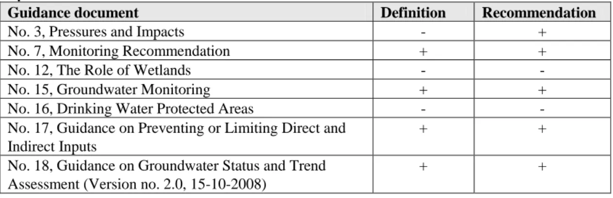
A number of EU guidance documents relevant for groundwater have been developed by the EC under the Common Implementation Strategy (CIS) of the WFD. In the majority of these guidance documents the use of a conceptual model is recommended and in several guidance documents a definition or description is also provided. There are two guidance documents that do not state conceptual models as an instrument (Table 2.1). These are the guidance documents about Wetlands and about Drinking Water Protected Areas. This is surprising because these subjects are suitable for the use of conceptual models.
Table 2.1: An overview of EU guidance documents relevant to groundwater. It is indicated whether or not conceptual models are recommended and/or defined.
Guidance document Definition Recommendation
No. 3, Pressures and Impacts - +
No. 7, Monitoring Recommendation + +
No. 12, The Role of Wetlands - -
No. 15, Groundwater Monitoring + +
No. 16, Drinking Water Protected Areas - -
No. 17, Guidance on Preventing or Limiting Direct and Indirect Inputs
+ +
No. 18, Guidance on Groundwater Status and Trend Assessment (Version no. 2.0, 15-10-2008)
+ +
When this report was being written, an EU guidance document about conceptual models was being developed. Parts of this report have been introduced to the group writing that guidance document.
2.2.2
The definition of a conceptual model in EU guidance documents
The definitions given in various EU guidance documents are more or less the same in terms of content: a schematic or simplified representation of the geohydrological system and its behaviour. However, there is some inconsistency with respect to the elements the conceptual models consist of. The models range from qualitative (Prevent and Limit) to quantitative (Groundwater Monitoring). The aim of the model also appears to differ, as on the one hand it serves quantitative calculations (Groundwater Monitoring), and on the other hand it indicates which qualitative processes can play a role (Pressures and Impacts). section 2.4 considers this in greater detail.
Text box 2.2: Definitions in different guidance documents.
2.3
The development and use of conceptual models
The analysis of EU guidance documents reveals that:
• the development of a conceptual model should form part of the characterisation of water bodies (guidance document nos. 3, 7, 15, 18);
• the degree of complexity of the conceptual model depends on the situation. In a complex situation where expensive restoration measures are applicable then extra investments in a good conceptual model can be worthwhile (guidance document no. 15);
• these conceptual models must be tested and further developed on the basis of new monitoring data (guidance document nos. 7, 15, 17, 18). The development of a conceptual model is an iterative process;
• it must be possible to say something about the reliability of the conceptual model. However no tangible qualitative criteria are mentioned (guidance document nos. 3, 7).
Moreover it is apparent that a conceptual model should be used in the case of:
• the characterisation of water bodies (guidance document nos. 3, 7, 15, 17, 18);
• the development and evaluation of the monitoring programmes (place and time) and the interpretation of monitoring data from both surveillance monitoring and operational monitoring as well as the monitoring quantity (guidance document nos. 7, 15, 18); • the derivation of the threshold values (guidance document no. 18);
• the assessment of the groundwater body status and trends in the groundwater body (GWD Annex III and guidance document no. 18).
Guidance document on Monitoring: ‘A conceptual model is a simplified representation, or working description, of how the real hydrogeological system is believed to behave. It describes how hydrogeologists believe a groundwater system behaves’.
Guidance document on Groundwater Monitoring: ‘Conceptual models are simplified representations, or working descriptions, of the hydrogeological system being investigated’. Guidance document on Preventing or Limiting Management and Indirect Inputs: ‘A conceptual hydrogeological model is the schematisation of the key hydraulic, hydro-chemical and biological processes active in a groundwater body’.
Guidance document on Groundwater Status and Trend Assessment: ‘Conceptual models are (...) a working understanding of the geological and hydrogeological system being studied’.
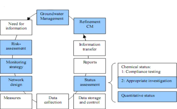
The aforementioned information is summarised in Figure 2.1. In this case it concerns the water management cycle as included in the EC brochure (EC 2008, p. 14). The cycle has also partly been included in the Dutch guidance for groundwater monitoring (VROM, 2006, p. 2). Here the figure is focused on the groundwater body status assessment (the same can be done for groundwater body characterisation and the determination of trends). In the ideal case the same conceptual model can be used for the separate components. Completing this iterative process should lead to an increased knowledge of the area. This accumulation of knowledge can be confirmed by adapting the conceptual models to it.
2.4
Information about conceptual models per guidance document
This section explains where conceptual models are found in each of the guidance documents and how the conceptual models are explained. Text taken directly from the guidance documents is italicised. We have assumed that readers of this section possess the guidance documents concerned.
Figure 2.1: The cycle for groundwater management, focused on the groundwater body status assessment. The colours indicate in which parts of the cycle a conceptual model can be used.
2.4.1
Guidance document about Pressures and Impacts (no. 3)
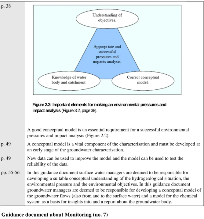
p. 38A good conceptual model is an essential requirement for a successful environmental pressures and impact analysis (Figure 2.2).
p. 49 A conceptual model is a vital component of the characterisation and must be developed at an early stage of the groundwater characterisation.
p. 49 New data can be used to improve the model and the model can be used to test the reliability of the data.
pp. 55-56 In this guidance document surface water managers are deemed to be responsible for developing a suitable conceptual understanding of the hydrogeological situation, the environmental pressure and the environmental objectives. In this guidance document groundwater managers are deemed to be responsible for developing a conceptual model of the groundwater flows (also from and to the surface water) and a model for the chemical system as a basis for insights into and a report about the groundwater body.
2.4.2
Guidance document about Monitoring (no. 7)
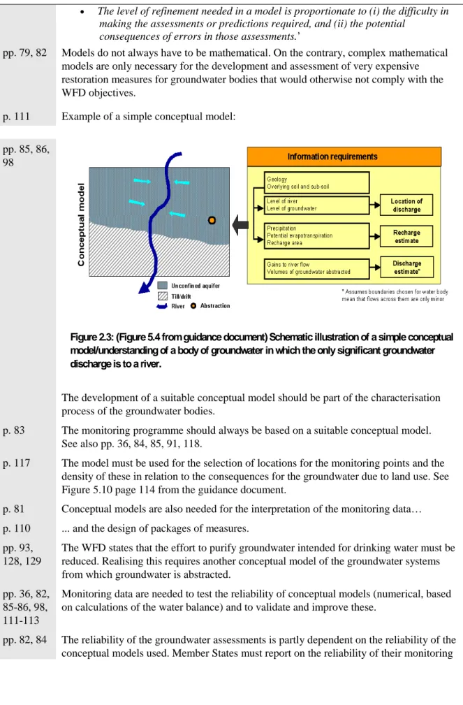
p.82 The guidance document about monitoring provides the most detailed definition of the conceptual model: ‘A conceptual model/understanding is a simplified representation, or
working description, of how the real hydrogeological system is believed to behave. It describes how hydrogeologists believe a groundwater system behaves.
• It is a set of working hypotheses and assumptions.
• It concentrates on features of the system that are relevant in relation to the predictions or assessments required.
• It is based on evidence.
• It is an approximation of reality.
• It should be written down so that it can be tested using existing and/or new data.
Figure 2.2: Important elements for making an environmental pressures and impact analysis (Figure 3.2, page38).
• The level of refinement needed in a model is proportionate to (i) the difficulty in making the assessments or predictions required, and (ii) the potential
consequences of errors in those assessments.’
pp. 79, 82 Models do not always have to be mathematical. On the contrary, complex mathematical models are only necessary for the development and assessment of very expensive restoration measures for groundwater bodies that would otherwise not comply with the WFD objectives.
p. 111 Example of a simple conceptual model:
pp. 85, 86, 98
The development of a suitable conceptual model should be part of the characterisation process of the groundwater bodies.
p. 83 The monitoring programme should always be based on a suitable conceptual model. See also pp. 36, 84, 85, 91, 118.
p. 117 The model must be used for the selection of locations for the monitoring points and the density of these in relation to the consequences for the groundwater due to land use. See Figure 5.10 page 114 from the guidance document.
p. 81 Conceptual models are also needed for the interpretation of the monitoring data… p. 110 ... and the design of packages of measures.
pp. 93, 128, 129
The WFD states that the effort to purify groundwater intended for drinking water must be reduced. Realising this requires another conceptual model of the groundwater systems from which groundwater is abstracted.
pp. 36, 82, 85-86, 98, 111-113
Monitoring data are needed to test the reliability of conceptual models (numerical, based on calculations of the water balance) and to validate and improve these.
pp. 82, 84 The reliability of the groundwater assessments is partly dependent on the reliability of the conceptual models used. Member States must report on the reliability of their monitoring
Figure 2.3: (Figure 5.4 from guidance document) Schematic illustration of a simple conceptual model/understanding of a body of groundwater in which the only significant groundwater discharge is to a river.
results in the catchment area management plans. Figure 5.8 (p. 114) from the guidance document shows how the monitoring programme can be adjusted to the reliability of a conceptual model.
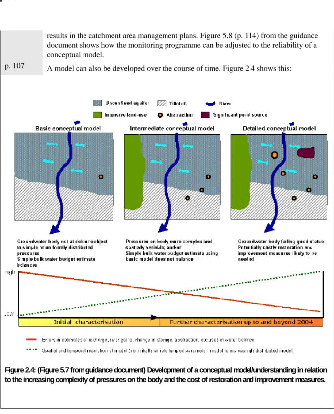
p. 107 A model can also be developed over the course of time. Figure 2.4 shows this:
2.4.3
Guidance document about Groundwater Monitoring (no. 15)
According to this guidance document the conceptual model plays a role: p. 12 a) in supporting the characterisation process (at risk or not at risk);
p. 10 b) as a basis for monitoring programmes (trend and status, operational and quantitative monitoring):
• selection of monitoring sites (pp. 14, 16, 19, 20); • selection of monitoring frequency (pp. 17, 20);
• selection of ‘what to monitor’ (core and selected determinants, p. 19);
Figure 2.4: (Figure 5.7 from guidance document) Development of a conceptual model/understanding in relation to the increasing complexity of pressures on the body and the cost of restoration and improvement measures.
p. 13 c) the interpretation of monitoring data;
p. 14 d) in the assessment of the WFD monitoring network.
p. 12 A definition is given: ‘Conceptual models/understanding are simplified representations, or working descriptions, of the hydrogeological system being investigated.’
And two types of conceptual models are distinguished:
a) The regional conceptual model; this model provides insight into the factors that play a role at the level of a groundwater body (for example, representativity of the monitoring network and the interpretation of monitoring data).
b) The local conceptual model; this model provides insight into the factors that affect the behaviour of individual monitoring points.
p.13 According to the guidance document the following information is needed for the development of a conceptual view/model of an area:
• construction details of the monitoring points; • the hydrogeological situation;
• view of the recharge sources and patterns; • the pattern of the local groundwater flow; • impact of abstractions;
• existing hydrochemical data; • size of the area; and
• possible information on travel times and groundwater age distribution. pp.1
3, 20
The monitoring data obtained can be used to test, validate and improve conceptual models.
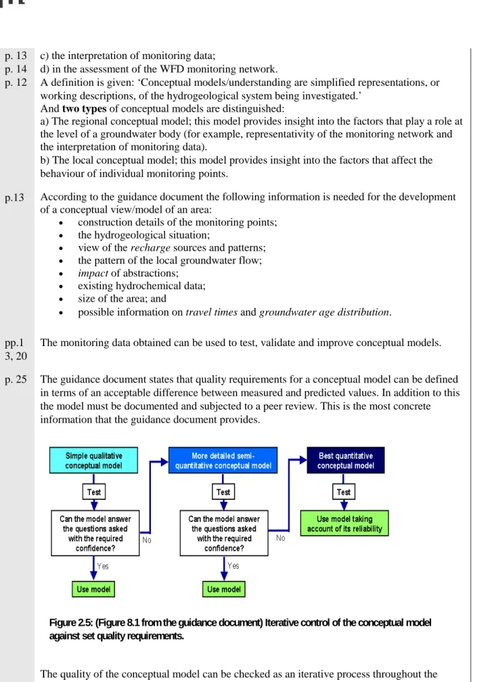
p. 25 The guidance document states that quality requirements for a conceptual model can be defined in terms of an acceptable difference between measured and predicted values. In addition to this the model must be documented and subjected to a peer review. This is the most concrete information that the guidance document provides.
The quality of the conceptual model can be checked as an iterative process throughout the entire monitoring programme. See Figure 2.5.
Figure 2.5: (Figure 8.1 from the guidance document) Iterative control of the conceptual model against set quality requirements.
2.4.4
Guidance document about Prevent and Limit (no. 17)
p. 17 The guidance document about Preventing or Limiting Direct and Indirect Inputs states that a conceptual hydrogeological model must be developed to determine if there is pollution either now or in the future.
p. 17 The conceptual hydrogeological model is defined as: ‘a schematisation of the key hydrological, hydro-chemical and biological processes present in the groundwater body.’ Where necessary, the processes in the unsaturated zone that exert an influence on the pollution must also be included.
p. 25 Specific monitoring might be necessary for the development of a conceptual model. These possible additional monitoring points can later be used as to ‘prevent and limit
monitoring’.
2.4.5
Guidance document about status assessment (Status and Trend Assessment)
p. 9 In this guidance document a conceptual model is described as: a schematisation of the hydrogeochemical properties and the groundwater flow of the groundwater system. This does not necessarily have to be a numerical model.
pp. 9, 10, etc.
Conceptual models are necessary for:
• the determination of significantly rising trends; • monitoring (location and frequency);
• the deviation from the standard starting point for trend reversal;
• the derivation of threshold values. For example, in the determination of a possible dilution / attenuation factor (See Annex 1 of the guidance document);
• the determination of the groundwater bodies status.
p. 9 The tests of the status assessment make use, for example, of the results from the characterisation (‘at risk’ determination) and the monitoring programme. According to this guidance document conceptual models have already been used for both of these. These conceptual models should be optimised based on the new data from the status assessment.
The use of conceptual models is stated in various tests (without further specifying how). p. 9 Information about the use of conceptual models can be found in the guidance document
on Impacts and Pressures (see section 2.1.1 in the guidance document) on Monitoring (see section 2.1.2 in the guidance document) and on Groundwater Monitoring (see section 2.13 in the guidance document).
3
Definitions of conceptual models
3.1
General
Besides its use in the GWD and the various guidance documents, the term 'conceptual model' has a history of different uses in the scientific literature. These different usages can cause confusion (for example, Bredehoeft, 2005; Van Gaans, 1998; Robinson, 2006; Seifert et al., 2008). In this report we distinguish three ways in which conceptual models are used: the fundamental (general scientific) conceptual model. This fundamental approach is the basis for the second form: the geohydrological conceptual model. And finally the conceptual model is distinguished as an instrument for knowledge exchange. Each form has its own purpose.
This chapter considers the three forms in greater detail and shall provide several examples. When researchers, (geo)hydrologists and policy makers communicate with each other it is important that they share a common understanding of what a conceptual model means and are aware of the differences regarding views about conceptual models within the various groups of users and end users.
3.2
The conceptual model: fundamental approach
Robinson (2006) has provided an overview of the different approaches used for working with
conceptual models. For example, he demonstrated that within scientific circles there are differences in the definition, starting points, method of development and manner of presentation of conceptual models. The agreement between the different approaches is that he considers a conceptual model to be a qualitative thought model that together with a collection of views serves to illustrate our impression of a part of the reality. It is also an instrument with which researchers and other parties can exchange ideas about aspects of that part of reality. A conceptual model is often the step before an operational model. The operational model serves to perform simulations or scenario calculations, for example. An operational model is used to quantitatively investigate how the modelled part of the reality would behave under the influence of the variation of certain variables and parameters. The knowledge acquired with this can be used to improve the conceptual model.
The conceptual model is therefore a widely used scientific term that is applied in various ways in different scientific disciplines. There are a multiplicity of definitions and descriptions that can differ strongly both within and between scientific disciplines.
Interestingly, studies that use a conceptual model mostly use the same basic elements (for example, Van Gaans, 1998; Inkpen, 2007; Van der Perk, 2006; Seifert et al., 2008; Heemskerk et al., 2003; Van Waveren et al., 1999). These studies describe the conceptual model with the aid of three elements:
1. The research area or research element; this is part of the reality that the conceptual model describes.
2. The concepts; these are the (theoretical) variables of a system.
3. The hypotheses; these indicate the relationships between the different variables or concepts. Note 1: every model is related to a part of the reality and the research area provides the boundaries for the concepts used within that subsidiary area of the reality. According to Van Waveren et al. (1999) defining the research area is an essential step in the construction of a conceptual model. Moreover, they argue that this definition must also determine the level of detail in the conceptual model in terms of both time and space.
Note 2: The concepts show the relevant variables for the model. With this a choice is always made on the basis of the researcher's assumptions. In general the concepts are theoretical and are not yet related to the values measured.
Note 3: The hypotheses indicate the different relationships between the concepts. These relationships are often represented in the form of mathematical formulae. On the one hand the hypotheses can be based on accepted theories and on the other hand on assumptions. The most important requirement of these hypotheses is that they may not be mutually contradictory.
The following examples further illustrate this principle of these basic elements.
Example 1: The conceptual model for research into the threat of groundwater abstraction by chemical laundries.
1. The research element is the spread and behaviour of trichloroethene in groundwater that is extracted for drinking water production.
2. The concepts are (amongst others):
- groundwater potentials (dependent variable); - groundwater flow rates (dependent variable);
- concentration trichloroethene in pumped up groundwater (dependent variable); - low-density aquifer;
- porosity aquifer;
- resistance separating (impermeable) layer; - abstraction rate;
- abstraction site; - natural replenishment.
3. Hypothesis: as the abstraction rate rises, the spread of the pollutant increases.
Example 2: The conceptual model for a study into the decrease of species diversity in nature areas.
1. The research element is the species diversity. 2. The concepts include:
- (change in) seepage and the groundwater status in the nature area; - permeability of the soil;
- natural replenishment; - abstraction;
- chemical substances; - nutrients.
3. The hypotheses are the relationships between the aforementioned variables and the research element.
3.3
The conceptual model, geohydrological approach
Within each scientific discipline a more fundamental approach can be used to construct a more applied conceptual model. The geohydrological approach is important for the WFD. Within geohydrology, conceptual models are viewed as one of the most 'thorny' components (Bredehoeft, 2005).
In the draft guidance document about ‘Conceptual Models’ (unpublished, 2008) use is made of a definition for conceptual models from McMahon et al. (2001). This states:
‘Conceptual model: A simplified representation of how the real system is believed to behave based on a qualitative analysis of field data. A quantitative conceptual model includes preliminary calculations for key processes.’
Put simply, a conceptual model is a simplified representation of how people assume a real system behaves, based on qualitative field data. A quantitative elaboration of a conceptual model contains preliminary calculations for the most important processes.
In addition to the definition of McMahon et al. (2001) other definitions are also used. In the
Netherlands, the Information Desk standards Water (IDsW) has compiled a dictionary that is largely based on the earlier ‘Hydrological glossary’ of CHO-TNO (IDsW, 2008). In this Aquo-lex the definition of a conceptual model is:
‘the description of the structure of a system with qualitative dependencies’.
Van Waveren et al. (1999) also use this definition in the ‘Good Modelling Practice Handbook’ that was compiled on behalf of the Directorate General for Public Works and Water Management, STOWA and the DLO-Staring Centre in the context of a study to create a standard framework for water management in the Netherlands. Only qualitative dependencies are stated in this definition.
An important characteristic of these applied conceptual models is that they are compiled for a given spatial scale. At this scale there are recognisable geohydrological concepts, such as aquifer and non-aquifer layers and surface waters. Figure 3.1 gives an example of a geohydrological conceptual model. Within the discipline of geohydrology, this illustration of a conceptual model is usually referred to as a geohydrological scheme. This scheme illustrates a system that contains aquifers with separating layers in between, which is the case for the majority of the Netherlands. The different concepts (aquifers and aquitards, water abstractions and precipitation) are illustrated in it, as well as the relationships between these concepts (the ‘fluxes’).
Within the discipline of geohydrology, a conceptual model is not an independent entity but instead is a part or phase in the cyclical or evolutionary process of model development. Figure 3.2 illustrates the Figure 3.2: Position of the conceptual model in a simplified modeling chain. (from: Refsgaard and
position of a conceptual model in a simplified representation of this cyclical process (Refsgaard and Henriksen, 2004).
On the basis of a clear problem or objective together with observations (knowledge of the area and field data, the 'reality’) a conceptual model can be constructed. With the help of a new or existing model code the hypotheses (relationships) from the conceptual model can be quantified (Figure 3.2). The complexity of the model code used can vary from simple calculations to a very extensive computer code. The operational model can then vary from the figurative 'back of the envelope calculation' to a very large computer model. The complexity of the model code and the model eventually chosen should be in accordance with the requirements that the outcomes from the model must satisfy.
The outcomes of the model are compared with the observations during the validation step. On the basis of this validation the conceptual model can be refined, if necessary, and the modelling chain repeated. Once the model has been verified, calibrated and validated, the scenarios can be calculated and on the basis of these the policy can be developed. Within this modelling cycle (Figure 3.2) the conceptual model is usually represented as a geohydrological scheme. This scheme can also be used as a tool for explaining the choices made for the far abstracter operational model.
3.4
The conceptual model as an instrument for knowledge exchange
between disciplines
One consequence of implementing the WFD and GWD is the increased interaction between the different groups of interested parties, including scientists, area managers and policy makers, each of whom has their own means of communication and their own jargon. A characteristic of this interaction is the communication between the different groups. Conceptual models can be a valuable aid in streamlining the communication between different groups and disciplines. Heemskerk et al. (2003) have shown that the joint drafting of a conceptual model by ecologists and sociologists can lead to a more integrated understanding of a problem area. The drafting of the models not only leads to the formulation of knowledge questions but it also reveals where gaps in knowledge are still present. Furthermore, it provides insight into the suppositions and assumptions that researchers from the different disciplines make. Such an interdisciplinary use of a conceptual model will not be enough to compile separate operational models. Within a discipline, additional concepts and relationships will need to be added. The conceptual model does, however, represent the communal knowledge and the degree of consensus between the different disciplines (and policy areas) concerning which processes (concepts and relationships) play a role within the research area of the conceptual model (Heemskerk et al. 2003).
In the broad arena of policy and knowledge associated with the implementation of the GWD, the knowledge of an area can be represented in an informative diagram of the area. This can contain recognisable geological and geohydrological elements such as sand, peat and clay layers in the soil. In addition to this, processes such as overfertilisation and nitrate load or factories that release
environmentally unfriendly substances into the soil and groundwater can be represented. In Figure 3.3 the conceptual model of a part of the Dutch sediment delta is shown in a drawing.
Figure 3.4: Flow of water and several ecohydrological processes associated with this in the Dutch landscape (from: Lieste et al. 2007).
Translation of terms in Figure 3.4
Basenrijk zoet grondwater Base-rich fresh groundwater CO2 productie CO2 production
Denitrificatie Denitrification Droogmakerij Reclaimed land Duinlandschap Dune landscape Grondwaterspiegel Groundwater level Laagveen polder Fen soil polder Oplossen van kalk Dissolving of calcium Rivierlandschap River landscape Schijnspiegel Perched water table Veen en klei Peat and clay Zand en grind Sand and gravel Zandgronden Sandy soils
Zee Sea
Zout en brak grondwater Saline and brackish groundwater
Figure 3.4 shows a more schematic representation of the groundwater and surface water flows. The drawing defines as it were terms such as 'precipitation', 'injection' and 'inundation'. For communication purposes it is important that the terms are used unequivocally. A conceptual model as shown in Figure 3.4 can help to provide such clarity. Then whether or not the processes represented exactly concur with the reality (or the numerical model) is less important.
3.5
How is the term conceptual model used in the guidance documents?
In Table 3.1 the guidance documents are classified according to the type of conceptual model (fundamental, geohydrological and interdisciplinary) and according to the nature of the model
(qualitative, quantitative). This classification is not absolute and is subject to interpretation. Its purpose is to further illustrate the differences in the definitions of the conceptual models.
With respect to the building blocks of a conceptual model, the different guidance documents are not completely consistent with each other. In particular, there can be considerable differences between the intended numerical or operational details of this conceptual model. An operational model can be built from a conceptual model based on operational values, model results and measurements. Measuring and modelling the relevant processes for this step usually costs a lot of effort. Compared to a conceptual model, the result of an operational model is more tangible because the results produced by the model (numerical) can be directly compared with the field observations. Qualitative elements are mainly used for the conceptual model, whereas quantitative elements are needed for the operational model.
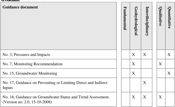
Table 3.1: An overview of EU guidance documents relevant to groundwater. The type of conceptual model used is indicated. Guidance document Fun dam ent al G eoh yd rol ogi cal In te rd is cip lin ar y Qu al it at ive Qu an tit at ive
No. 3, Pressures and Impacts X X X
No. 7, Monitoring Recommendation X X
No. 15, Groundwater Monitoring X X
No. 17, Guidance on Preventing or Limiting Direct and Indirect Inputs
X
No. 18, Guidance on Groundwater Status and Trend Assessment. (Version no. 2.0, 15-10-2008)
X X X
In the different guidance documents the greatest inconsistency is found in the role of the quantitative elements. In the guidance document on Pressures and Impacts (no. 3) it concerns a schematisation of the groundwater flow rates and the chemical processes in a water body. Quantitative elements do not appear to play a role in this conceptual model and neither have these elements been quantified on the basis of measurements yet. The guidance document on Groundwater Monitoring (no. 15) on the other hand discusses quality requirements for a conceptual model that can be defined in terms of an
acceptable difference between measured and predicted values. In other words a completely quantitative (or numerical, mathematical or operational) model. The guidance document on Status and Trend
Assessment states: ‘a conceptual model is not necessarily a numerical model’. The guidance document
on Monitoring (no. 7) says more or less the same but adds: ‘Conversely, complex mathematical models are only necessary for the development and assessment of very expensive restoration measures for groundwater bodies that would otherwise not comply with the WFD objectives'.
The descriptions in the guidance documents therefore vary from: ‘no quantitative elements’ to ‘a completely quantitative model’.
In view of the purpose and use of the guidance documents it is hardly surprising that the scientific, fundamental, conceptual models are not mentioned. The conceptual models in the guidance documents have a geohydrological or interdisciplinary focus. The three elements of a fundamental conceptual model, stated in section 3.2, are clearly a component of these geohydrological and interdisciplinary models. The guidance documents concerning monitoring (nos. 7 and 15, Table 3.1) assume a
geohydrological conceptual model. Due to the analytical nature of this subject, predominantly focused on measurement, the number of scientific and policy-related disciplines is limited. The other guidance documents (Table 3.1) assume more of an interdisciplinary conceptual model. This is mainly due to the broader scope of the subject and the need to examine this from the perspective of several disciplines.
3.6
Summary
No clear overarching definition or methodology has emerged from the literature consulted. Each policy area or scientific discipline uses its own methods. Even within disciplines, such as geohydrology, the term ‘conceptual model’ is subject to constant discussion. Three different conceptual models were distinguished for this study, the fundamental scientific, the geohydrological and the interdisciplinary. The conceptual models referred to in the guidance documents are geohydrological or interdisciplinary in nature. Generally speaking no explicit choice is made in the guidance documents for a qualitative or quantitative model.
4
Examples of conceptual models
This chapter provides several examples of conceptual models to demonstrate what practitioners understand a conceptual model to be. With the exception of the first example, which is used for characterisation reports of the groundwater, none of the examples have been developed for the WFD/GWD. With a few minor adjustments, some of these models could also be used for various objectives within the WFD/GWD such as monitoring, status determination, et cetera. For each example it is stated how the model is constructed and where, with some modification, it could be used.
4.1
The answering of the ‘water balance question'
In the groundwater characterisation reports for the various partial catchment areas, a conceptual model is used to answer the 'water balance question' (Meinardi, 2005). This characterisation forms a part of the 'risk' determination according to the guidance document on Pressures and Impacts. This conceptual model mainly concerns the argumentation needed to conclude that 'a negative answer to the water balance question' is unlikely, and for this a general description of the geohydrological situation in the Netherlands is predominantly used.
Description
Meinardi (2005) describes the water balance as: IN = OUT + RETENTION for which RETENTION is the change in volume over the period considered. As RETENTION is relatively far smaller than the IN and OUT flows then it is assumed that the IN and OUT flows are in balance. If the IN and OUT flows are in balance then the groundwater table remains at the same level. Although the groundwater table on higher sandy soils has structurally fallen as a result of land consolidation (Rolf, 1989), this assumption seems to be justified as the groundwater tables appear to have stabilised over the last few decades (Kremers and Van Geer, 1998; 2000). This has not been affected by the intrusion of brackish or saline water in areas such as the reclaimed land in the west of the Netherlands. For the water balance no distinction is made between saline water and freshwater. The assumption has a strong basis in view of the geohydrological conditions in the majority of the Netherlands. Policy is targeted at ensuring that abstractions do not exceed the extractable quantity of water. In most areas the surface run-off is linked to the drainage basin or the ground level and this accordingly controls the groundwater table. Insofar as there is a water deficit this shall be replenished via lateral inflow from Germany, Belgium and the large surface waters. Based on this argumentation using a conceptual model, Meinardi (2005) concludes that ‘a negative score for the water balance question' is unlikely. Meinardi (2005) further elaborates the water balance for ‘shallow clay and peat' groundwater bodies and ‘sand and dune’ groundwater bodies, for which the basic equation for the water balance is extended with different terms, for example, the infiltration from the surface water, drainage to the surface water, and groundwater abstractions.
4.2
Large-scale groundwater pollution near Apeldoorn
The following description of the large-scale groundwater pollution near Apeldoorn (Zijp et al., 2007) could be an example of a conceptual model for the guidance document on Preventing and Limiting. The example reveals which processes are taking place in the area and what the potential problems are. The model makes use of a cross-section of the subsoil with geohydrological construction, the spread of the pollution and the most important parties involved, and a map on which important clusters of groundwater pollution are visible.
Description of the situation
The location near Apeldoorn is polluted with volatile organochlorine compounds. These
organochlorine compounds are heavier than water and therefore sink down relatively quickly. Many (often historic) sources are present on the site, mostly small-scale commercial activities such as laundries, paper factories and printing works. Groundwater pollution to a considerable depth has been demonstrated because the pollutant is a highly mobile substance that entered the soil a long time ago. The size of the polluted area is estimated to be 75 million m3 (Apeldoorn, 2005).
Figure 4.1: Cross-section of the influence of the groundwater pollution on the groundwater (Apeldoorn, 2005).
Translation of terms in Figure 4.1
Grondwaterbelangen Groundwater interests Drinkwaterwinning Drinking water abstraction Wateroverlast Waterlogging
Grondwatersanering Groundwater remediation Woonwijk Housing estate
Proceswaterwinning Process water abstraction
Spreng Seeping well
Riool Sewer
Warmtekoude opslag Heat storage Infiltratiegebied Infiltration area Kwelgebied Seepage area Grondwaterspiegel Groundwater level
Kanaal Canal
Kleischotten Clay partitions
Translation of terms in Figure 4.1
Grondwaterverontreiniging Groundwater pollution Stroombanen grondwater Groundwater flowlines
Ondoorlatende laag (formatie van Drenthe) Impermeable layer (formation of Drenthe)
Geohydrological situation and consequences for the dispersal
The groundwater under Apeldoorn flows in an eastern direction (see Figure 4.1). The pollutants are transported with this. The groundwater under Apeldoorn splits into a deep and a shallow groundwater system (Figure 4.1). The majority of the pollutant flows into the shallow groundwater system. The groundwater flow rate there is about 10 to 20 m per year. In the deeper subsoil the flow rate is
50 - 100 m/year. As a result of retardation, the displacement rate of the front of the pollution is a factor of 2 slower than the groundwater flow rate (HgbII, 2007; Hgb, 2006, p. 4.5). Each year 500,000 m3 of clean groundwater is affected by the pollution (Apeldoorn, 2005).
The groundwater in the shallow groundwater system flows under the Apeldoorns Canal and seeps up in the area on both sides of the Wetering. The deeper groundwater flows in the deep aquifer. From this aquifer groundwater is abstracted in the area of Twello for drinking water production (see Figure 4.2). It is estimated that the pollution of the deep groundwater shall not reach the drinking water extraction for another 100 years.
Figure 4.2: Overview of Apeldoorn municipality and surroundings; the most important clusters of groundwater pollution are indicated. (diverse bronlocaties = various source locations)
4.3
The freshwater-saline water boundary in the Netherlands
This example concerns a conceptual model of the freshwater-saline water boundary in the Netherlands (Stuurman and Oude Essink, 2006) and can be used for status assessment (intrusions). The example provides a description of the evolution and the current situation, for which use is made of a map with
the depth of the brackish water/saline water boundary and the boundary between the freshwater area and the brackish/saline water area and an east-west hydrogeological profile with the dispersal of fresh groundwater and saline groundwater.
Figure 4.3: Depth of the saline water interface with the boundary between the ‘fresh’ and brackish-saline region. Areas that are susceptible to silting are marked with hatched lines.
Translation of terms in Figure 4.3
Kilometers kilometres Brabant en Limburg brak-zout grens in meter
NAP
Brabant and Limburg brackish-saline boundary in metres NAP
Zeeland (eerste) Brak-Zout grens in meter NAP Zeeland (first) brackish-saline boundary in metres NAP
Nederland (overig) C1-1000 mg/l grens in meter NAP
Netherlands (other) Cl-1000 mg/l boundary in metres NAP
Grensvlak in meter NAP Interface in metres NAP Gebied kwetsbaar voor optrekken zoet-zout
grensvlak
Area vulnerable for rising fresh-saline interface
Hoofdgrens zoet-zout t.b.v. KRW monitoring Main boundary fresh-saline for WFD monitoring Gebied kwetsbaar voor laterale verzilting vanuit
Peelhorst
Area vulnerable for lateral silting from Peelhorst
Description
The freshwater-saline water patterns in the Netherlands are strongly determined by the Holocene coastal development. This is especially true for the seepage areas in the tip of North Holland, Zeeland, Friesland and Groningen, which were only reclaimed after the Middle Ages.
The map showing the depth of the brackish-saline interface (Figure 4.3) exhibits the various
phenomena. On the sandy soils the interface is generally deeper than in the reclaimed land area. In the Roerdalslenk, between Roermond and Eindhoven, the interface is very deep. It is locally deeper than NAP – 750 m. This is caused by prolonged infiltration from Germany and the Belgian Kempen and the fact that at this location large terrestrial deposits occur to a considerable depth. In the Eem valley (seepage area) between the infiltration areas the Utrechtse Heuvelrug and the Veluwe, the interface lies 50-100 metres higher than in the bordering infiltration areas, see Figure 4.4.
Figure 4.4: East-west hydrogeological profile between the borders with Germany and the North Sea with the dispersal of fresh and saline groundwater.
In the east of Brabant, the northeast of Limburg and the east of Gelderland and Overijssel the interface is relatively shallow. That is because in these areas highly impermeable marine deposits from the tertiary period are found. The saline formation water has still not been leached out. In North Holland the ‘freshwater bubble of Hoorn’ is clearly visible. This bubble is thought to have arisen during the Holocene, possibly under a peat area present at that time (Beekman, 1991). This fresh groundwater is very rich in methane and iron and so up until now it has not been an attractive source for drinking water production. Along the coast, the freshwater bubbles are visible under the dune soils. At the
Hondsbossche Zeewering and the Oude Rijn the water is silted. This was caused in the past by seawater intrusions via the surface water. Under the Flevopolders there is a lot of freshwater that flows there from the Veluwe. The interface is locally higher. This is caused by the absence of clay layers as a result of which a strong upward flow occurs.
The mapped out brackish-saline water interface shows a clear division between a zone in the west and north of the Netherlands in which saline groundwater, with the exception of the dunes and the
‘freshwater bubble of Hoorn’, occurs near the surface and the zone to the south or west of this where the freshwater-saline water interface is located far deeper.
• In the eastern part of the Netherlands the interface is relatively shallow. This is caused by the shallow location of highly impermeable marine clay layers from the tertiary period.
• The interface is strongly related to coastal development in the Holocene period.
4.4
Influence of groundwater on surface water
The next example describes a generic conceptual model for the relationship between groundwater and surface water for the higher situated parts of the Netherlands under various hydrological conditions (Verhagen et al., 2007). The conceptual model could be used as a basis for the status assessment of the effects on aquatic ecosystems. Based on a figure with a series of cross-sections of the subsoil, the processes that play a role under various hydrological conditions are described. The example does not describe a specific location but provides a generic picture of the interaction between groundwater and surface water in the higher located run-off areas in the Netherlands.
Description
Groundwater and surface water are part of the same hydrological system. In the Netherlands the precipitation surplus ensures a groundwater replenishment of about one metre per year. To prevent waterlogging the excess of groundwater is discharged via the (partly man-made) system of streams, ditches, channels and drains. A large proportion of the surface water therefore consists of discharged groundwater. The surface water quality is the result of a certain mixing ratio of groundwater originating from various depths. This mixing ratio is dependent on the conditions of discharge; in the case of rapid discharge the mixing ratio shifts towards the shallower, faster discharge components. In the case of basic discharge, the deeper, slower discharge components exert more effect. Due to the differences in water quality at various depths, the shifts in the mixing ratio have consequences for the surface water quality (Rozemeijer and Broers, 2007).
In Figure 4.5 this concept is visualised for a schematic cross-section of a catchment area. The
uppermost groundwater is mostly polluted by agricultural activities. The deeper groundwater is cleaner because many polluting substances are strongly absorbed by the shallow subsoil (phosphate and heavy metals) or are broken down (nitrate). In Figure 4.5 the pollution status of the subsoil is visualised with colour (from red to brown).
Figure 4.5 also shows that under dry conditions the surface water is fed from the clean deeper
groundwater (HS class 1). Under wet conditions the shallow water also contributes to the surface water discharge. After even wetter periods still, the uppermost groundwater flows through very short
pathways via small ditches, channels and drains and even via surface run-off into the stream. These
Translation of terms in Figure 4.5
HS-Klasse HS class
Actieve stromingscomponent Active flow component Grondwaterstand Groundwater table Drainagebuis Drainage pipe Hogere concentraties aan landbouwstoffen in
bovengrond
Higher concentrations of agricultural substances in topsoil
rapid surface pathways in particular, convey a lot of agricultural pollutants into the surface water system.
On the basis of this conceptual model, Verhagen et al. (2007) subsequently explain the contribution of nitrogen from the groundwater to the surface water.
Figure 4.5: Visualisation of the conceptual model for the relationship between groundwater and surface water; groundwater flow components that contribute to the surface water under different discharge conditions (HS classes).
4.5
Influence of groundwater on the terrestrial ecosystem
The following example describes how groundwater affects the Lemselermaten nature reserve
(Aggenbach and Jansen, 2004). This example could be used for the status assessment of the effects on the terrestrial ecosystem at Lemselermaten. The example provides a topographical and a system description, with a three-dimensional profile and gives a detailed description of the hydrological and geochemical processes in the groundwater.
Topography
The Lemselermaten nature reserve was a grassland area until the end of the 1980s and was the last remaining orchid-rich, oligotrophic fen meadow in Twente. The species richness of the vegetation of this grassland has gradually fallen since the 1970s. The plot referred to as the ‘Oude Maatje’ in this study is mowed each year. In 1988 a plot was purchased that lies immediately west of the Oude Maatje. After purchase, this plot was impoverished via a management policy of mowing and removal. In the study this area of grassland together with the bordering alder wood was referred to as the ‘Westelijke Maatje’ or ‘Nieuwe Maatje’. In 1990 an agricultural plot on the elevated sand sheet to the east of the original reserve was purchased. This plot has been turned into a nature reserve and with this the topsoil was removed to a depth of 15 to 30 cm and the drainage pipes were removed as well. A ditch in the plot was also filled in. In the study this area was referred to as ‘Oostelijke Maatje’.
System description
Lemselermaten lies between the Weerselerbeek and the Dollandbeek that flow to the north and the south of the area respectively. The plots investigated lie on the south side of the Weerselerbeek. The central part consists of an elevated sand sheet with agricultural grounds and wet heathland. This elevated sand sheet gradually transitions into the lower soils of the stream valleys that consist of alder woods and fen meadow. In the lowest parts Scorpedio-Caricetum diandrae used to grow (Jansen, 1991; Westhoff and Jansen, 1990). The alder woods developed from grassland that was deserted by farmers in the 1940s and 1950s. A large part of the elevated sand sheet was reclaimed and drained. The hydrology has also been affected by the channelling of both streams (circa 1960) and a groundwater abstraction by Vitens (previously WMO) of 1 million m3/year 1 km to the south of the reserve at Weerselo. This abstraction started in 1966. The ground level decreases in the Lemselermaten can be ascribed for 90% to a lowering of the stream level and for 10% to groundwater abstraction.
The low stream valley soils of Lemselermaten are fed by base-rich groundwater that originates from the aquifer above the tertiary clay layer (see Figure 4.6). As this layer is thinner in the northwest of the area, the porosity is less on the downstream side of the aquifer than the upstream side. In this geohydrological transition zone, this groundwater seeps up in the Lemselermaten and ensures a buffering there of between pH 5.5 and 7.0 and a base saturation of the cation adsorption complex of 50 to 100%. Although the calcium level is usually less than 0.3%, in 1991 calcium was occasionally found in the deeper soil layer (CaCO3 level of 0.3-5.0). This is correlated with the high pH values of
6.5-7.0. Since the 1960s the concentrations of SO42- and Cl- in the groundwater have markedly
increased as a consequence of overfertilisation (measurements WMO). Recently infiltrated rainwater has also started to flow from the elevated sand sheet used for agriculture. This water is low in bases but high in SO4