The Europeanisation
of spatial planning
in the Netherlands
The Europeanisation of spatial
planning in the Netherlands
The Europeanisation of spatial
planning in the Netherlands
David Evers and Joost Tennekes
The Europeanisation of spatial planning in the Netherlands © PBL Netherlands Environmental Assessment Agency The Hague, 2016
PBL publication number: 1885 Corresponding author david.evers@pbl.nl Authors
David Evers and Joost Tennekes Acknowledgements
We hereby thank Anton van Hoorn, Hub Diederen, Mark van Veen, Frits Kragt, Pieter Boot, Olav-Jan van Gerwen, Jos Notenboom, Jan de Ruiter, Filip de Blois, Henk van Zeijts, Margo Mulder, Marjolijn Mercx (PBL); Edward Geus (RIVM), Anne van Doorn (WUR), Stefanie Dühr (Radboud University Nijmegen), Jan van Oosten (Stibbe), Bas Waterhout (TU-Delft) and Wil Zonneveld (TU-Delft), for their contributions.
Thanks also go to the participants in the provincial focus group meetings: Henri Stakenburg (GL), Reinier Zweers (GL), Wim Sniedt (L), Raymond Creemers (L), Tim van der Avoird (NB),
Rini Gielis (NB), Frank van Lamoen (NB), Sidony Venema (HNP), Lieuwe van den Berg (GR), Harry van der Meer (DR), Jolanka van der Perk (FL), Paul Veldhuis (NH), Jacqueline Sellink (UT), Conny Raijmaekers (UT), Leo van der Brand (ZL), Inge Vermeulen (ZH), Erik de Haan (ZH), Johanna Swets (HNP) and Ton Heeren (IPO); and those in the national focus group: Henriette Bursee (IenM), Mireille Groet-Thewissen (IenM), Daniël de Groot (IenM), Anne Lammertink (IenM), Renske van Tol (IenM), Marijn van der Wagt (IenM) and Kitty de Bruin (VNG). Lastly, we thank the interview respondents: Jan Backes (Universiteit van Maastricht), Joerg Knieling (HCU Hamburg), Stefan Greiving, (TU Dortmund), Susan Grotefels (University of Münster), Klaus Joachim Grigoleit (TU Dortmund), Noud Janssen (Ministry of IenM), Bernhard Stüer (University of Osnabrück), Mirielle Groet-Thewissen (Ministry of IenM) and Axel Kristiansen (Danish Ministry of Environment)
Graphics PBL Beeldredactie
Production coordination and English-language editing PBL Publishers
This publication can be downloaded from: www.pbl.nl/en. Parts of this publication may be reproduced, providing the source is stated, in the form: Evers D. and Tennekes J. (2016), The Europeanisation of spatial planning in the Netherlands. PBL Netherlands Environmental Assessment Agency, The Hague.
PBL Netherlands Environmental Assessment Agency is the national institute for strategic policy analyses in the fields of the environment, nature and spatial planning. We contribute to improving the quality of political and administrative decision-making, by conducting outlook studies, analyses and evaluations in which an integrated approach is considered paramount. Policy relevance is the prime concern in all our studies. We conduct solicited and unsolicited research that is always independent and scientifically sound.
Contents
MAIN FINDINGS Summary 8
Europe seen and unseen 8
Dutch spatial planning affected by the EU 10 A new role for national government 10 Substantive impacts of EU policy 11 Coupling EU policy and spatial decisions 13 Conclusion 14
Full Results
1 Impact of EU policy 16
1.1 Motivation 16
1.2 Objectives and scope 16 1.3 Theoretical framework 17 1.4 Research question 20 1.5 Methodology 21 1.6 Structure of the report 21
2 Multilevel governance 22
2.1 A fourth layer of governance 22 2.2 National developments 31 2.3 Denmark 36
2.4 Conclusion 38
3 Policy coordination 42
3.1 Spatial policy and sectoral regulations 42 3.2 Mapping impact 42
3.3 EU policy in the Netherlands 44 3.4 Composite map of EU policies 61 3.5 Tensions and solutions 62 3.6 EU policy coherence in Hungary 69 3.7 Conclusion 71
4 Process and system 72
4.1 Coupling between spatial planning and EU policies 72 4.2 Coupling and decoupling pathways 75
4.3 Impact of the system: international comparison 86 4.4 Conclusion 93
Summary
– Dutch spatial planning is becoming increasingly more European. This Europeanisation is the result of various EU sectoral policies influencing planning, but also of domestic policy choices. Nearly the entire Dutch territory is covered by one or more EU policies. – EU policy serves to heighten long-standing tensions
between spatial and sectoral policy. A lack of coordination can create conflict, particularly when opposing policy objectives converge within a particular area. Spatial planning can help resolve these kinds of conflicts.
– The Dutch Government has assumed responsibility for a well-functioning spatial planning system. Because the national government serves as an interface between policymaking (EU level) and policy implementation (provinces and municipalities), its responsibility, at the very least, should entail ensuring clear communication between the various layers of government about the implementation of EU policy. In addition, it also means providing expertise, and voicing the concerns of sub-national governments within Europe. This responsibility places limits on the decentralisation of spatial planning.
Europe seen and unseen
Over a decade ago, the former Netherlands Institute for Spatial Research (one of the forerunners of PBL Netherlands Environmental Assessment Agency)
published a study called Unseen Europe (Van Ravesteyn and Evers, 2004). Drawing on a large number of examples, the authors showed how agreements made at European Union (EU) level have a substantial impact on domestic spatial planning. This impact is still not fully recognised by Dutch spatial planners today, in part due to the lack of spatial policy at EU level, and because EU policy is usually translated into national legislation or regulations by sectoral departments. Unseen Europe revealed, among other things, cultural tensions between the cultural differences between the strict and equal application of generic EU policy and the Dutch spatial planning tradition of collaboration, compromise and tolerance.
The study’s main recommendation was at the same time a firm warning: ‘Although it certainly remains necessary to conduct spatial policy at the national level – if for no other reason than to coordinate EU sectoral policies and integrate them into the planning system – doing so without regard to the growing influence of Brussels will doom it to failure’ (Van Ravesteyn and Evers, 2004: 6). Much has changed within Europe since Unseen Europe was published. The EU has grown from 15 to 28 Member States, and from around 380 million inhabitants to over 500 million in 2014. This has made the EU more diverse and complex; it now has more languages, cultures and development levels, and more divergent opinions on the EU. Since the Dutch and French referenda on the EU Constitution in 2005, the previously unquestioned acceptance of growing EU integration has dissipated, and in recent years a crisis of confidence has emerged, poignantly exemplified in current discussions of a ‘Brexit’. Even so, the EU’s day-to-day work continues; new regulations and guidelines are adopted, policies are implemented or abandoned, policy proposals are submitted and new policy fields explored.
Much has changed in the Netherlands in the same period, as well. The Fourth National Policy Document on Spatial Planning Extra (Vinex) was replaced, first by the National Spatial Strategy (Nota Ruimte) and then by the National Policy Strategy on Infrastructure and Spatial Planning (SVIR). This last document, as its predecessor, envisioned a smaller role for national government and abolished most urbanisation policies including the internationally well-known Green Heart. The position of planning changed within government, as well, and was removed from the name of the ministry.1 The statutory planning system was overhauled multiple times, as well.2 These structural changes were reasons for PBL to revisit the questions addressed in Unseen Europe. The current study goes further than its predecessor, and seeks not only to survey but also explain the relative influence of the European Union. In order to put the Dutch situation in perspective, a few foreign case studies were included (on Denmark, Hungary and Germany).
Dutch spatial planning affected
by the EU
Many issues relevant to spatial planning are determined by agreements made at the EU level. Most of the Dutch territory is covered by one or more EU policy regimes. This can be seen in Figure 1, a map of the areas where EU policy affects the Netherlands. This map should not be construed as proof of a ‘meddlesome Brussels’, as it is nearly impossible to disentangle Dutch and EU interests. After all, Europe and the Netherlands, on the whole, have the same policy objectives (e.g. fair competition and clean air). Moreover, almost all EU policies were adopted with Dutch consent. In fact, many of the policies that are most important to spatial planning were championed by the Netherlands. Two prominent examples are the Habitats Directive and the Floods Directive.
To determine which EU policies should or could be presented on the map, six ‘impact types’ were distinguished:
1. Area designation: areas or locations that are conferred a special legal status
2. Intervention areas: locations that require specific measures to be taken
3. Spatial investments: areas and infrastructural networks that receive EU subsidies
4. Sectoral investments: spatial distribution of non-spatial subsidies
5. Generic rules: spatial policies or projects affected by general EU rules
6. Territorial cooperation: mandatory and voluntary schemes for cross-border cooperation Not all the ways in which EU policy affects spatial planning could be depicted cartographically. Research or planning obligations, for instance, can have a substantial impact on the planning process, but are difficult to represent on a map. Other EU policies were left off the map deliberately, such as those on noise pollution, because they do not substantively impact planning. Although each Member State is obliged to measure noise pollution according to the same method, and must draft action plans to deal with problematic cases, the EU has not set any maximum thresholds or performance requirements itself. Furthermore, the map also omits spatial projects initiated to comply with EU policy. This includes, for example, wind parks constructed to achieve EU renewable energy targets, or expansions of port areas to handle the increase in biofuel imports. Although such developments affect both the process and content of spatial planning, the choice of method (for renewable energy, wind vs solar power; for biofuel, import vs production) and the choice of development location are
fully at the discretion of the Member State. Finally, it was obviously not possible to map out the changing
governance relationships between national government, provinces and municipalities resulting from EU policy. In brief, the map contains many but not all of the ways in which spatial planning is affected by EU policy. Although not all EU impacts are presented on the map, Figure 1 still shows that there are almost no ‘blank’ areas in the Netherlands. Nearly the entire Dutch territory is covered by some EU policy regime, sometimes several. The diversity in policy approaches is also clearly evident; for example, as regards the distribution of restrictions and incentives (nature policy uses both strategies by demanding the conservation of Natura 2000 areas on the one hand, and by making investments via Life+ on the other). This demonstrates just how extremely varied and complex the impact of EU policy on spatial planning can be. This study distinguishes three areas in which EU policy may affect spatial planning: via governance, content and process.
A new role for national government
The arrival of the European Union as a ‘fourth layer of governance’ has altered relations between the other three levels in the Netherlands. As there is no spatial planning on EU level, the EU policies that are relevant to spatial planning are developed and drafted by various sector departments. Each Directorate-General operates in its own way. This means that numerous policy regimes exist alongside one another – something that can be seen, for example, in the various EU subsidy flows. The Common Agricultural Policy is designed and formulated on EU level, with funds being allocated and distributed by national governments to individual farms. The EU Structural Funds (ESF and ERDF), however, are also broadly determined at the EU level, but are shaped and administered regionally (in the Netherlands by provincial partnerships). Both businesses and governments can be beneficiaries. The various actors operate according to their sector department and administrative level within an arena of multilevel governance. In practice, national governments and sub-national governments can have diverging interests. The Dutch national government, for example, has advocated the abolition of the Structural Funds for the more affluent Member States, whereas Dutch provincial authorities opposed such a change. These complex relationships are very dynamic. To begin with, the number of Member States continues to rise, as do the number of Directorates-General, other authorities, policy initiatives and platforms. Two examples relevant for planning are the Directive onMaritime Spatial Planning (CEC, 2013) and the European Innovation Partnership on Smart Cities and Communities (EIP-SCC). In addition, changes within Member States also affect multilevel governance. Since the adoption of the Dutch National Policy Strategy on Infrastructure and Spatial Planning (SVIR), most spatial planning responsibilities have been devolved to provincial or municipal authorities. These sub-national government authorities have limited say in the EU decision-making process concerning the policies that they are later required to implement. As Member State representatives, national governments have a more powerful voice in EU policymaking and are formally held accountable in cases of non-compliance.
In order to operate more effectively within this arena, Dutch sub-national authorities have expanded their presence in Brussels, by establishing their own offices (House of the Dutch Provinces and G4), and by interfacing with bodies such as the Committee of the Regions and the European Parliament. They share information on EU policy via the ‘Europadecentraal.nl’ knowledge portal, and publications such as ‘Handreiking Europaproof Gemeenten’, a guide for municipalities on EU policies (Kenniscentrum Europa Decentraal, 2008). Furthermore, the Dutch national government has taken steps to ensure compliance with EU policy via the Dutch Act on
compliance with EU regulation by public entities 2012 (Wet Naleving Europese Regelgeving Publieke Entiteiten) and to ensure that the limit on the budget deficit as agreed in Europe is not being exceeded via the Sustainable Public Finances Act 2013 (Wet Houdbare Overheidsfinanciën). Particularly this last measure is controversial and has the implications for domestic intergovernmental relations. The case study of Denmark, a country with a spatial planning tradition comparable to that of the Netherlands, reveals quite different multilevel governance. For example, the Danish Parliament has a great deal of say over what can be negotiated at the EU level, and a critical stance by domestic politicians can slow the EU
policymaking process. Although more headstrong during policymaking than the Netherlands, Denmark is more compliant once it comes to implementation. Because Danish spatial planning has been falling under the Ministry of Environment for some time now, EU environmental directives are not viewed as particularly problematic in Denmark. The tensions are experienced more at the local level.
In summary, multilevel governance is one aspect of the Europeanisation of spatial planning. From the perspective of its responsibility for the spatial planning system, the Dutch national government should focus its attention on the problems that may arise due to suboptimal vertical
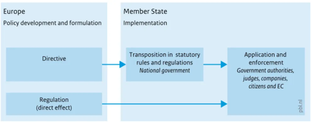
coordination between municipalities, provinces, national government and the EU – also because suboptimal horizontal coordination between sectors may cause bottlenecks for spatial planning. The Dutch national government cannot leave this horizontal coordination completely up to sub-national authorities. After all, Europe holds Member States accountable for the implementation of EU policy. Moreover, the national government is in a better position than provinces or municipalities to change legislation at the EU level, and it is also the one who partly determines the level of flexibility when transposing EU directives into national legislation (see Chapter 4).
Substantive impacts of EU policy
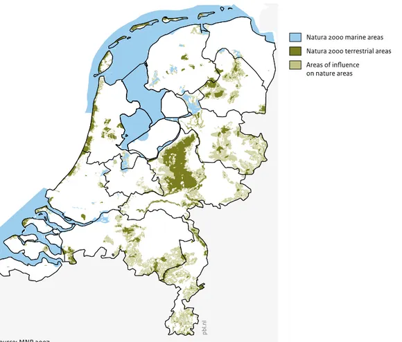
Figure 1 shows how policies can overlap: in other words, multiple EU policies sometimes apply within the same physical area or location. This accumulation of policies can be seen more clearly in a close up of the composite map; see Figure 2 for two regional close ups.Figure 2 shows that EU policies naturally sort themselves out geographically. Investments that have their origins in, for example, regional policy are concentrated in cities, while those in Life+ and agriculture policies are found outside urban areas. Despite this, overlapping or adjacent policy objectives can still create tension. Investments supported by the TEN-T policy and the structural funds increase the attractiveness of urban areas, and a consequent increase in human activity may cause local environmental quality – especially of air and water – to decline. On the other hand, domestic subsidies that are meant to strengthen the local economy may be considered unlawful state aid.
There is a certain amount of tension between policies in rural areas as well, principally between ecological goals (biodiversity, water quality) on the one hand, and economic production (agricultural subsidies, Trans-European Networks and structural funds) on the other, as can be seen in Figure 2. In addition to the Natura 2000 areas themselves, areas in the vicinity can also be affected by Natura 2000 policy because of the likely presence of endangered species. This can produce tensions with agricultural policy as the bulk of CAP subsidies are not used for rural development but for agricultural production, which can have detrimental effects on wildlife. Figure 2 shows that the subsidies received by farmers in Barneveld and Nijkerk near the Veluwe, the largest unbroken Natura 2000 area on land, are among the highest in the Netherlands. It also shows that the water quality south of the nature reserve De Nulde, near Putten, does not meet the standards of
the Water Framework Directive. Finally, EU subsidies for regional development have been granted for the ‘sustainable business park’ of Stuttersveld Zuid, while the air quality at the nearby A12 motorway is below EU standards. It is likely that the business park development will attract additional traffic, thus worsening local air quality. So far, these kinds of coordination problems between sectoral objectives are resolved in planning practice; this conclusion was drawn in a series of discussions with provincial spatial strategists and from earlier studies on the ‘stacking’ of EU policy (Zonneveld et al., 2008). The fact that a lack of coordination of EU policy can lead to problems in practice is demonstrated by the
case study on Hungary. In Hungary, the objectives of the Trans-European Networks (TENs) that are intended to solve the shipping bottlenecks on the Danube run directly counter to the implementation of both Natura 2000 policy and the Water Framework Directive, as well as the investments made by the structural funds. In the end, the Hungarian authorities were obliged to balance EU transport ambitions (and their related subsidies) against EU environmental policies and the possible fines for non-compliance.
In summary, the spatial planning system of the Netherlands is becoming ever more European, in the
Figure 2
Nature
Natura 2000 marine areas Natura 2000 terrestrial areas Areas of influence on nature areas Overlapping EU policies (composite map detail)
Policies (selection) CAP subsidy (pillar 1 + pillar 2) in euros/ha 1 000 500 250 1 Regional policy 0 6 km
Sources: see composite map
Public safety (Seveso)
Safety zones Policies in urban areas (Rotterdam region)
Policies (selection) PM10 exceeded NO2 exceeded Perimeter of industrial area pbl.nl 0 3 km
Policies in rural areas (western Veluwe)
Air quality
Water quality Insufficient
Trans-European Transport Network (TEN-T)
sense that the Dutch National Spatial Structure (in the Dutch policy document SVIR, describing the national interests) consists increasingly of EU policy. Over the past 20 years, the amount of relevant EU spatial policy has increased, while national interests have decreased substantially. With the increase in EU policy, the influence of a sectoral approach has grown implicitly for spatial planning, in terms of both practical solutions and institutional change. The Dutch Government must remain vigilant to ensure that practical solutions can still be achieved. However, it cannot do so alone; the knowledge and capacity available on local levels also need to be utilised effectively.
Coupling EU policy and spatial
decisions
Dutch spatial planning is aimed at accommodating competing land-use interests by making integrated assessments and seeking optimal solutions. Terms such as consensus and compromise are at the heart of Dutch planning. Many EU standards and objectives are seen as inflexible by Dutch planners; these standards are non-negotiable and leave little room for manoeuvre. Whether a project complies with EU standards or contributes to EU objectives is becoming more important. Dutch planners are increasingly faced with the imperatives of sectoral policies.
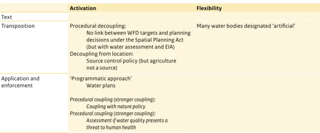
Whenever spatial decisions – such as land-use plans or building permits – depend on EU policy, we speak of ‘coupling’. The degree of coupling is determined in various ways. Legislation sometimes already mandates a strong coupling with spatial planning, such as under the Seveso Directive and the Birds and Habitats Directives: these directives call for explicit spatial zoning.
In other cases, coupling is achieved when EU policies are implemented into the Dutch system. There are various options for managing the coupling. The procedure, for example, can be designed in such a way that not every spatial decision needs to be checked against EU policy, independently. The Water Framework Directive is an example of this. The procedure itself could be made more flexible, for instance, by enabling other considerations to be weighed in the decision. The degree of coupling and whether this coupling is likely to produce problems also depends on the characteristics of the legal system and the spatial planning system. If it is easy, both formally and practically, to gain access to the courts to appeal against a spatial decision, the interested parties have more options to point out that the decision is inconsistent
with EU policy, and thus the result is a strong degree of coupling.
The importance of the spatial planning system in determining coupling can clearly be seen by comparing the Dutch and German situations. In Germany, the most spatially relevant EU policy is administered by sectoral planning (Fachplanung), instead of spatial planning (Raumplanung/Bauleitplanung). For Fachplanung, the sectoral department organises both the horizontal coordination with other sectoral interests and the vertical
implementation of the plan. Consequently, EU policy is more in line with German practice. Although Germany also has its problems, these are of a different nature than those in the Netherlands. In Germany, EU policy provided stakeholders in Germany with more possibilities to participate in and appeal against decisions than the system was accustomed to handling. In the Netherlands, the same requirements resulted in fewer bottlenecks because the Dutch system is designed differently on this point.
There are various ways to deal with a strong coupling. A common strategy is simply to accept it as a given and engage in a strategy of ‘Europe proofing’ – making every effort to ensure a plan or project is completely in line with EU policy (e.g. by conducting thorough research as a foundation for a plan, and by prioritising EU policy in order to avoid litigation). In this sense, EU policy has increased the juridification of spatial policy. However, the Dutch national government can also manage the level of coupling by, for example, rethinking a directive’s implementation. Such ‘re-transposition’, if approved, can be performed so that EU standards no longer apply in certain cases. The programme approach is an alternative strategy. This combines a number of spatial projects into a package, together with measures sufficient to offset the negative effects and achieve the EU target. In this way, not every spatial project needs to be checked separately for compliance, only the programme as a whole. In summary, in order to avoid bottlenecks and retain the local decision-making discretion traditionally enjoyed in Dutch spatial planning, a continual management of the coupling between EU policy and spatial planning is nee-ded. However, a strong degree of coupling cannot always be avoided, and may sometimes be desirable, such as from the perspective of public health. In order to deal with coupling more effectively, the EU system was taken as the starting point in the preparations of the new Dutch Environment and Planning Act. Whether this will really prevent bottlenecks from arising between EU policy and spatial planning remains to be seen. For now, it is contri-buting to the Europeanisation of Dutch spatial planning.
Conclusion
What has changed since the publication of Unseen Europe? Over the last decade, various strategies have been developed in spatial planning practice to deal with EU policy and prevent bottlenecks. This is making spatial planning more international, sectoral, programme-oriented and – through ‘Europe proofing’ – more juridical. In other words, Dutch spatial planning is becoming more European and this Europeanisation is beginning to iron out differences between Dutch and EU approaches. This means there is less friction and, in case such friction does occur, it can be dealt with more swiftly and easily. Nevertheless, there is also a role for the national government with respect to its responsibility for ensuring the planning system functions well.
There are various reasons for the national government to maintain an active role in spatial planning. In the first place, the government should ensure that integrated assessments and decision-making are still possible. The national government remains the party that converts EU policy into national regulation and, thus, designs the coupling with spatial planning. The national government also has to set up and coordinate any national
programmes, ensuring that flexibility exists on a local or regional level. In cases of policy conflicts, the national government may attempt a re-transposition, in consultation with the European Commission. Although this is no easy task, it is even harder for sub-national authorities to achieve, as they are further removed from the European arena. Sometimes managing the coupling between Dutch spatial planning and EU regulation calls for a reform of the national planning system itself – and this is then also a national government task.
In the second place, the role of government is also that of an intermediary. It should not merely be a conduit for spatially relevant EU policy, although this may be suggested by the decentralisation of spatial planning and passing on accountability with respect to EU-policy compliance. After all, the national government actively participates in the EU policy-making process. In its pledge of responsibility for the planning system, the national government needs to inform itself of how provinces, municipalities and water boards plan to implement EU policies and listen to their opinions on the matter. This would help to ensure that these parties have a voice early on in the EU policy-making process. Although the provinces are present in Brussels, their voice is never quite as powerful as that of the national government.
Notes
1 In the reorganisation of ministries in 2010, the departments of spatial planning and the environment – previously under the former Ministries of Housing, Spatial Planning and the Environment (VROM) and Transport, Public Works and Water Management (V&W) – were brought under a new Ministry of Infrastructure and the Environment (IenM). The department of Housing now falls under the Ministry of the Interior and Kingdom Relations (BZK).
2 Since the implementation of the Spatial Planning Act (2008), government authorities use different legal instruments than before, and responsibilities have been reallocated. The Environmental Licensing (General Provisions) Act (2010) and the Crisis and Recovery Act (2010) subsequently made a number of changes to the legal system. The new Environment and Planning Act (in force in 2018) again will thoroughly change the spatial planning system.
FULL RESUL
TS
FULL RESUL
ONE
Impact of EU policy
1.1 Motivation
Various studies have noted that myriad EU policies impact spatial developments and the spatial planning process in the Netherlands (e.g. Janssen-Jansen and Waterhout, 2006; Van Ravesteyn and Evers, 2004; Zonneveld et al., 2008). This impact has sometimes caused problems for planners operating within the comprehensive integrated approach due to conflicting aims or insufficient flexibility. The difficulties encountered in practice, however, cannot be completely attributed to the policies themselves; they are also (and probably mainly) the result of the physical and institutional attributes of the Netherlands and choices made in transposition (Rli, 2008). Moreover, EU policies can create opportunities and regions and municipalities are already taking advantage of multilevel governance by seeking EU support for their own regional agendas (Rob, 2013).
The need to understand the possible effects of EU policy on spatial developments and planning has increased with the decentralisation of spatial policy in 2011. The National Spatial Structure, which is the responsibility of the national government, increasingly consists of EU policy. Even though the national government translates many EU policies into domestic policy, sub-national authorities must still understand how they can affect their own spatial policies. Do uncoordinated EU sectoral policies converge or overlap in a problematic way? How much leeway is there for finding solutions at the national/sub-national level, and how do other countries deal with these issues?
1.2 Objectives and scope
The aim of this study is to determine the influence of EU policies on Dutch spatial planning and explore solutions for observed problems. This is necessary for ensuring that a well-functioning spatial planning system exists (for which the Dutch government has pledged its
responsibility), the proper implementation of EU policy and strategic action in the EU arena.
Because of this aim, this study does not look at matters such as the development of a potential European spatial planning (e.g. Faludi and Waterhout, 2002) and the many discussions concerning territorial cohesion, which since the Lisbon Treaty (2009) falls under the jurisdiction of the EU (e.g. Waterhout, 2008; Dühr et al., 2010; Faludi, 2010), unless they are found to have a demonstrable effect on the Dutch spatial planning system. This study contributes to the literature on the Europeanisation of spatial planning (see Giannakourou, 2012, for an overview), although it should be noted that most of these studies (e.g. Waterhout, 2007; Faludi, 2014) focus less on the ‘hard’ influence of sectoral directives, regulations and subsidies and more on the ‘soft’ influence of policy concepts and voluntary EU transnational partnerships. This research focus should not be taken to imply that EU policy is the only, or even main, factor affecting the Dutch spatial planning system. In fact, the major challenges now facing Dutch spatial planning, such as demographic developments or the breakdown of the land-use model, have very little, if anything, to do with EU policy (see e.g. Kuiper and Evers, 2011, for an overview). This study, therefore, makes no attempt to conclude how important or far-reaching the influence of EU policy is compared with other factors. Moreover, our examination of the impact of EU policy on Dutch spatial planning is by no means intended to suggest or reinforce an image of ‘European interference’. It should be stressed that EU policy is not simply imposed: the Netherlands has always been involved in the policy development and decision-making process in Brussels. In fact, many of the directives that affect spatial planning were championed by the Netherlands. Furthermore, the observation that the spatial planning process is influenced by or conflicts with certain EU policy does not mean that the policy in question does not serve a worthy purpose. The aim of this study is only to show that influence exists and how it Although no official spatial planning policy exists at the EU level, EU sectoral policies exert influence on spatial developments and spatial planning in the Netherlands. This influence can concern the content of spatial policy (i.e. land use and urban development), the decision-making process relating to spatial projects and governance within the spatial domain. This chapter provides a framework for investigating the various ways that EU policy can affect spatial planning.
ONE ONE
could be dealt with, rather than engage in a normative discussion of the merits of particular policy objectives or subsidiarity.
1.3 Theoretical framework
To help understand the relationship between the Dutch spatial planning system and EU policy, this study presents a conceptual framework which defines and unpacks both terms into constituent parts. As regards the causal relationship being explored, this study takes a very broad view; both direct and indirect effects as well as intended and unintended consequences of EU policies are considered. This is the spirit of many Territorial Impact Assessment (TIA) methods currently under development (Evers, 2011). The terms influence, impact and effects are usually used more-or-less interchangeably throughout this study. In general, ‘influence’ denotes the existence of some kind of causality, while ‘impact’ is used analytically to highlight a specific relationship.
1.3.1 Types of influence
In the introduction to their book Grenzeloze Ruimte (Borderless space), Janssen-Jansen and Waterhout (2006) state that the EU influences spatial planning in four distinct ways. This distinction is used in this study to categorise the origins (see Figure 1.2) of the European influence. Firstly, according to those authors, the EU can act as a ‘stimulator’ by providing subsidies; in this case it makes something new possible. The more general term ‘incentives’ is used in this study, as some incentives can reinforce the existing situation; for example, in the case of income subsidies for farmers. Secondly, Europe can, according to Janssen-Jansen and Waterhout (2006), be a ‘hindrance’ through regulations
that restrict planning initiatives (e.g. by forbidding state aid). This study uses ‘rules’, again a more neutral term. Although many rules can be considered a hindrance, they can also provide structure, and even act as a stimulator by reducing uncertainty. Thirdly, the EU is an ‘arena’ where actors involved in spatial planning can interact (Janssen-Jansen and Waterhout, 2006); for example, to draw up best practices or discuss documents such as green papers and white papers (Van Veen and Heinen, 2013). The publication of benchmarks (naming and shaming) is a tried and tested way of exerting informal pressure. Similarly, providing information about spatial developments or the impact of EU policy reinforces this process of Europeanisation. With time, a common language and conceptual apparatus can develop among planners operating in the EU arena, which can influence policy at home (Faludi, 2010). In some cases, this ‘soft policy’ process can lead to a request for ‘hard policy’ in the form of formal rules or incentives. Fourthly, Europe is, in some cases, a ‘necessity’; for example, when a spatial issue can only be properly addressed in a cross-border way (e.g. flooding or air pollution) or if international interdependence (e.g. between sea ports) requires coordination and binding agreements. As this study aims to explore the influence of EU policy rather than the policy development process, ‘Europe as necessity’ is not very relevant as an independent category. The other three types of EU influence (incentives, rules and playing field), therefore, comprise the first layer in Figure 1.2. The influence of EU policy on Dutch spatial planning depends on the ‘sensitivity’ of the Netherlands to the particular policy. A study by the Dutch Council for the Environment and Infrastructure (VROM-council, 2008) argued that two factors determine sensitivity to EU policy; here, these are called ‘intermediary factors’
Figure 1.1
Definition of research area
Source: PBL
Dutch spatial planning
Demography Technology Economy EU policies Other factors
Other factors
Research area
ONE
because they comprise the two middle layers of the figure. The first layer of factors consists of spatial/ geographical characteristics. Rules concerning viniculture in mountainous areas, for example, are obviously irrelevant to this flat coastal country, and thus to its spatial planning system. On the other hand, as a highly urbanised country, the Netherlands would be relatively more sensitive to EU environmental policies (Rood et al., 2005). In many cases, environmental quality in the Netherlands ranks amongst the worst in the EU (for an overview, see Natuur & Milieu, 2011). Similarly, the economic geography of the Netherlands has made all its regions ineligible for cohesion policy funding directed at economic development (the former Objective 1 areas). The second layer of intermediary factors, the institutional characteristics, relate to how spatial planning is
organised, defined and implemented. The way in which access to the courts is arranged, for example, is an
important factor determining the sensitivity of individual Member States to EU regulations which rely on citizens for their activation (Backes, 2006). Administrative relationships between national government, provinces and municipalities and other stakeholders (governance) also affect how a certain EU policy is interpreted and implemented. Finally, the Netherlands can be sensitive to EU policy as a result of the informal rules and standards that exist in the spatial planning system. In the Netherlands, spatial development takes place in consultation with many different actors, and an attempt is made to balance and, to a certain extent, trade off interests. This tradition of consensus, compromise and tolerance, but also the desire to balance policy objectives, can influence the approach taken to EU policy in the Netherlands and, therefore, how EU policy affects the spatial planning system.
Figure 1.2
Influence of EU policies on spatial planning
Source: PBL EU policy Intermediary factors Spatial planning Content Governance Process Rules (regulations and directives) Incentives (subsidies) Arena (concepts, forums) Spatial (environmental quality, urban structure, economic geography) Institutional (politics, administration, practices) pbl.nl
ONE ONE
It is also important to describe how EU policy can impact planning (bottom layer). First of all, EU policy can affect spatial development; for example, if certain areas are zoned in a particular way (e.g. the Habitats Directive and the Seveso Directive). EU policy, for example pertaining to the internal market, can also affect the intensity and direction of flows (e.g. traffic, migration or trade), which can indirectly affect the spatial planning system. Secondly, EU policy can affect the spatial planning process by, for example, mandating research (e.g. environmental impact assessments) or setting public procurement rules. Lastly, EU policy can affect governance relationships, primarily as a result of the institutional sensitivities discussed above. For example, the mandatory co-financing required under the structural funds can affect intergovernmental budgetary negotiations.
1.3.2 Degree of influence
The influence of EU policy is notoriously difficult to quantify. Jacques Delors once predicted that, by the end of the 1990s, 80% of all socio-economic policy legislation in the Member States would come from the EU (cited in Christensen, 2010: 34). Moore (2008) estimated that 60–80% of all local and regional legislation in the EU would have its roots in EU policy. In the early 2000s, it was believed that 60% of all legislation, and even 80% of environmental legislation in the Netherlands, would originate in Europe (cited in Bovens and Yesilkagit, 2010). Bovens and Yesilkagit (2010) attempted to calculate this empirically. The result was much less extreme than earlier predictions; fewer than 20% of all parliamentary acts and ministerial decisions in the Netherlands were due to the implementation of EU directives (although this percentage was higher for environmental policies). Applying the same methodology to other Member States produced similar results.1 However, calculations such as these say nothing about the influence of these regulations in practice or the nature or desirability of this influence.
Very few empirical studies have been carried out on the effect of EU policy on policy processes in the Member States. One important exception is Fleurke and Willemse
(2006, 2007), who investigated the influence of the EU on ‘policy files’2 in Flevoland. The results show that more than half of all the files studied were influenced by the EU. What was striking was how many were indirectly affected (i.e. through regulations imposed by a higher level of government). Influence varied according to the policy file; the EU’s influence on culture and education was very weak, but relatively strong on spatial planning (the environment and the economy, in particular), affecting 62.5% of policy files in Lelystad, 36.0% in Almere and 73.9% in Flevoland. This study, therefore, confirms the idea of Europe as important but ‘unseen’ as far as spatial planning is concerned (Van Ravesteyn and Evers, 2004). In addition, Fleurke and Willemse (2007) defined six indicators for how EU policies can affect policy files of sub-national authorities (see Table 1.2).
These results nuance the picture commonly painted of Europe as a hindrance (e.g. Corbey and Verdaas, 2007; De Zeeuw, 2013). In the cases of Almere and Lelystad, the number of opportunities was greater than the number of constraints. For the province of Flevoland, this was the reverse, although only slightly (53% and 57%, respectively). Lelystad stands out, with 81% of all EU influence considered an opportunity. In an earlier study into spatial planning and environmental policy files using data from Lelystad, Fleurke and Willemse (2006) found that a significant proportion of the influence on spatial planning was regarded as positive (in most cases complementary). In no case was EU policy considered an obstruction to municipal policy – at worst (33%) it was considered as hampering. Even in these cases, this says little about the desirability of either policy: a proposal for a recreational centre in Lelystad was found to conflict with the Birds Directive (Fleurke and Willemse, 2006: 95), both of which are worthy objectives.
This last example also demonstrates just how difficult it is to assess the influence of EU policy on spatial decisions and policy processes at every level in the Netherlands based on criteria such as opportunities and constraints. In fact, it is impossible to disentangle Dutch and EU
Table 1.1
Percentage of policy files influenced by EU policy
Municipality of Lelystad Municipality of Almere Province of Flevoland
No effect 51.5 64.2 45.1
Effect 48.5 35.8 54.9
- Direct 12.5 16.7 61.5
- Indirect 96.9 86.7 46.2
N 66 81 51
ONE
‘interests’, as Europe and the Netherlands, on the whole, work towards the same policy objectives (e.g. fair competition and clean air). Moreover, nearly all EU policies were adopted with Dutch consent. In fact, many of the most relevant rules for spatial planning were proposed or championed by the Netherlands, two prominent examples being the Habitats Directive and the Floods Directive. Given the inextricable interlinking between EU policy and Dutch policy frameworks and the similarity in policy objectives, ‘influence’ is perceived mainly in terms of goodness-of-fit.
Nevertheless, there are some distinct differences between EU and domestic policy. One concerns inflexibility of the former. EU law takes precedence over national law and an EU rule cannot simply be changed by national governments if implementation problems are encountered in practice. The Dutch notion of ‘tolerance’ (pragmatic non-enforcement) is an unknown concept in Brussels (Van Ravesteyn and Evers, 2004). Because of this, EU policies (e.g. Natura 2000) generally take precedence over national policy (e.g. National Ecological Network) in spatial planning practice. This can also be seen in the spatial planning decision-making process; individuals can lodge a complaint against the government should it fail to act in accordance with EU legislation. A report of unlawful state aid, for example, can have significant and unexpected ramifications for a spatial development project.
A second difference is that EU policy often creates international dependencies and therefore alters governance relationships. Because of the Water Framework Directive and the Floods Directive, for example, planning decisions on water quality and quantity are now taken at the river basin level. Even without enforcement by the European Commission, a unilateral decision could incur resistance from the
international partners. The same applies to EU programmes such as Interreg that provide subsidies for cross-border cooperation. In each case, and as shown above, EU policy can hamper, limit, encourage,
complement or facilitate national policy. This effect, and its desirability, depends very much on the positions of the parties involved. However, it is because of this diversity that any analysis of the influence of EU policy on the spatial planning system must be inductive and open. The next section describes the research questions and methodology used to explore the influence of EU policies on Dutch planning.
1.4 Research question
This study investigates the influence of the EU on spatial planning in a broad context, namely all three aspects of spatial planning as presented in Section 1.3.1. With this in mind, the following research question and sub-questions were defined.
How, and to what extent, is EU policy responsible for changes in Dutch spatial planning?
1) What influence does the EU have on governance in the Dutch spatial planning system?
i) How does the EU, as a new layer of governance, change governance relationships at the national level?
ii) How do Dutch actors in the spatial domain attempt to influence EU policy?
iii) Which EU policies result in new governance constructions?
iv) Which changes in spatial planning governance are taking place in the Netherlands and how does this change the influence of the EU?
2) What influence does the EU have on the content of the Dutch spatial planning system?
Table 1.2
Types of EU influence on policy files
Constraints Opportunities
Enforcement: the EU compels an authority to undertake a decision it would not have taken otherwise. Example: Habitats Directive.
Invitation: the EU sets the local agenda and the sub-national authority has the possibility of withdrawing from the incentive, but the incentive is sufficiently attractive to warrant taking the according decision.
Hampering: if a sub-national decision can only be implemented with the necessary cooperation or permission of the EU, or if European rules limit the discretion in the formulation or implementation of a policy. Example: public procurement.
Facilitation: when local officials welcome the obligation of an EU rule to improve decision-making or because EU funds expedite an existing project. Example: public procurement. Obstruction: desired alternatives are not considered because
of EU (non-decision) influence. Example: Habitats Directive.
Enabling: an unattainable desire that can be fulfilled with the support of the EU. Example: regional policy.
ONE ONE
i) Which EU policies require zoning in the Netherlands?
ii) Which EU policies require measures to be taken in the spatial domain?
iii) Which EU policies influence spatial planning through investment?
iv) To what extent do EU policies overlap and/or conflict?
3) What influence does the EU have on the Dutch spatial planning process and system?
i) What is the relationship between spatial planning decisions and sectoral objectives?
ii) Which factors determine the strength of this relationship?
iii) Which strategies are used to manage EU impact?
1.5 Methodology
Rather than exploring every EU policy in detail for its potential impact, a decision was made to investigate three broad themes in this exploratory study, which conform to the three aspects of spatial planning as defined above. Each of these sub-studies has its own focus and approach and is briefly described below.
1.5.1 Multilevel governance
The arrival of the European Union has created a ‘fourth layer of governance’ in the Netherlands. Policy formulated at the EU level can affect the Member States through the national spatial planning system. The institutional setting also continues to change, as do the policies themselves – a factor which needs to be borne in mind when investigating impact on governance. At the same time, the national government is transferring spatial planning responsibilities to provincial or municipal authorities, including tasks relating to EU policy. In addition, it has decentralised the responsibility for achieving EU policy objectives. This has consequences for the division of roles in the spatial planning system and for the way in which provinces and municipalities respond to EU policy. In cases like renewable energy, the national government has taken a more active role. The tension between decentralisation within the Netherlands and centralisation at the EU level has implications for the national government with respect to its stated responsibility for the spatial planning system. Additional perspective is gained by comparing the Dutch case with the situation in Denmark, where radical institutional reform has had far-reaching consequences for the spatial planning system.
1.5.2 Spatial planning and coordination
Although most EU sectoral policy ‘interests’ are not actually spatial in their definition, they can often be
placed on a map. This is because achieving these interests, for example, requires certain areas to be given a special status, which may prohibit certain activities or developments. Areas in which measures need to be taken to meet a certain target can also theoretically be placed on a map, as can areas that receive EU funding. There is however no mechanism, such as a spatial vision, for coordinating these interests at the EU level. If several conflicting EU policies converge in the same location, this can have unexpected or undesirable effects. There are, for example, clear tensions between CAP subsidies, nature conservation and water quality, but also between regional and competition policy. The situation in Hungary is discussed by way of comparison since various uncoordinated EU policies converge along the Danube.
1.5.3 Process and system
Not all spatially relevant EU policy is implemented through the spatial planning system. Depending on the type of policy, a decision is made to link, or couple, sectoral policy objectives and the spatial planning system. Strong coupling can be regarded as problematic (too inflexible or insufficient latitude, as with air policy), but a lack of coupling can present a missed opportunity for achieving policy objectives. By actively managing this coupling, the right balance can be found between achieving sectoral policy objectives and spatial planning objectives. Examples of such management are programmes that ensure that not every project needs to be checked separately for compliance, as well as implementing a nature policy where protection of species is less area-specific. The Dutch situation is compared with the German spatial planning system, in which sectoral and integrated spatial planning exist alongside one another.
1.6 Structure of the report
The following three chapters describe the three sub-studies of this research. Each chapter includes a case study from a certain Member State, putting the Dutch situation into perspective.
Notes
1 That is, 15.5% for the United Kingdom, 14% for Denmark, 10.6% for Austria, 3% to 27% for France, 1% to 24% for Finland and 39% for Germany (Exadaktylos and Radaelli, 2012).
2 Policy files are defined by the authors as a group of decisions and/or activities serving a specific goal and taken and performed by or within the apparatus of a government, for example a spatial plan (Fleurke and Willemse, 2006: 93).
TWO
Multilevel governance
2.1 A fourth layer of governance
Although the popular media is rife with cries about a loss of sovereignty to the ‘Brussels super state’, the development of an EU layer of governance through an ongoing process of political, economic and legal integration is already a done deal. As the Dutch Council for Public Administration recently wrote: ‘For municipalities and provinces, Europe signifies a new governance reality, the importance of which cannot be overestimated […] because whether you see Europe as the solution or the problem, one thing is certain: Europe is a fact of life’ (Rob, 2013: 3). The effect of this ‘fact of life’ on governance relationships in the spatial planning system comprises the focus of this chapter.Before starting, it is first important to properly define what the ‘EU level’ is. Faludi and Waterhout (2002: 21) noted that: ‘Although not a state (not even a nascent one), the EU/EC still has institutions that perform state-like functions and work towards integration.’ The EU exerts influence on all kinds of governance relationships within the Member States. For the Netherlands, it can be viewed as a fourth layer of governance (as opposed to government).1 The effect of EU political and policy processes on the various government authorities, departments and national and international interest groups has long been a subject of study. A vast amount of research was conducted into multilevel governance in the years following the Maastricht Treaty, a period that the increasing importance of the region and the erosion of the nation state also became topical (Sharpe, 1993; Hooghe and Marks, 2001). More recently, there has been a renewed focus on multilevel governance, due to the expansion of the EU, decentralisation within the Member States and the consequences of the Lisbon Treaty for regions in general (Ladrech, 2010; Hooghe et al., 2010;
Mandrino, 2008) and the policy concept ‘territorial cohesion’ in particular (Faludi, 2010; Dühr et al., 2010). These studies add nuance to the literature on EU impact, as this turns out to depend very much on the (changing) institutional setting in the Member State concerned (Featherstone and Radaelli, 2003; Pitschel and Bauer, 2009; Møller Sousa, 2008). For example, the implementation of the structural funds in the Netherlands and Denmark was not found to cause any significant changes in public administration (Yesilkagit and Blom-Hansen, 2007), while this is most certainly the case in other Member States.
In the public administration literature, the institutional arena that has developed at the EU level is usually called the European Administrative Space (EAS). Many studies examine how the EAS develops over time, particularly the evolving role of the European Commission (EC) as the focal point of this development. It was recently found that people who work in the EC, including seconded national experts, have a weak relationship and little contact with their national governments (Trondal and Peters, 2012). Also, the autonomy of the EAS (in relation to the Member States) increases with increasing institutional capacity at the EU level. The EAS has a homogenising effect on national institutions as they are all affected by the same or similar rules, and because they all take part in the EU decision-making process. It is therefore possible to talk of a certain convergence in governance systems in Europe (Knill, 2001) and the emergence of a network of government organisations at various levels that work together in certain policy areas (Hofmann and Turk, 2006, in Trondal and Peters, 2012). That the EAS exists as an entity does not however imply that it is unified. In fact, fragmentation is endemic even within the ‘most European’ of EU all institutions, the The arrival of a ‘fourth layer of governance’ has altered governance relationships in the Netherlands, including those relevant to spatial planning. As there is no specific EU spatial planning policy, the EU’s influence is fragmented and differs from one policy area to the next. This influence changes as EU institutions change and policies evolve. The activities of Dutch actors (e.g. the House of the Dutch Provinces, Euro MPs and national representatives) in Brussels may also affect planning governance. Moreover, changes in governance within the Netherlands (e.g. decentralisation of spatial policy, reforms, budgetary cuts, administrative restructuring and the transfer of risk) also determine the influence of EU policy. To put the Dutch situation in perspective, it is compared with multilevel governance and spatial planning in Denmark. Although there are many similarities between the two countries, Denmark has taken a very different approach to EU policy-making.
TWO TWO
Commission: ‘research suggests that internal integration of the Commission does not seem to profoundly penetrate the services. […] A portfolio logic seems to be overwhelmingly present in the policy DGs. […] This observation echoes images of the Commission administration as fragmented with weak capacities for hierarchical steering, accompanying inter-service “turf wars” that is marginally compensated by presidential control and administrative integration’ (Trondal and Peters, 2012: 6–7). Given that spatial planning is a very broad policy area without its own EU Directorate-General (DG), this institutional fragmentation is an important factor determining the influence of EU policy on spatial planning governance.
This chapter explores how multilevel governance affects spatial planning in the Netherlands. First of all, a description is given of the EU bodies that have the most influence on spatial planning, followed by a brief introduction of a few policy areas that have, or will have, an impact on the spatial domain. Each EU policy area has its own policy development pathway, its own governance system and, therefore, its own influence on planning. The second part of this chapter deals with governance at the national level in the Netherlands. The many domestic developments in and around planning (such as decentralisation) have had a clear effect on multilevel governance. The Dutch situation is then put into perspective by comparing it with multilevel governance and spatial planning in Denmark.
2.1.1 The European field of influence and
spatial planning
Because not all of the EAS is relevant to Dutch spatial planning, this section only treats the most important parts. As the original (Dutch) version of this study was
concluded in early 2014, some information required updating. Even though much of the information is now current, some parts of this section could still be outdated. European Commission
The executive body of the EU, the European Commission (EC), is arguably the most ‘European’ of EU institutions. Each Member State supplies a commissioner who swears an oath to represent the interests of Europe as a whole and not that of his or her own Member State. The EC is the only body that may make new policy proposals, and is also responsible for ensuring that policy is implemented properly. In 2014, there were 33 DGs and a coordinating Secretariat-General. Because the EC is organised by field of expertise, the DGs form a logical point of contact for the various policy areas. As described above, coordination within the EC is rather loose, to say the least, with DGs primarily focusing on their own tasks. The EC does however produce an annual summary of priorities, called a work programme (CEC, 2013c). Since the EU Treaty does not provide a clear mandate for EU intervention in spatial planning, it is not surprising that no spatial planning DG exists,2 or will exist in the foreseeable future. The most relevant DGs that propose new legislation that can affect spatial planning in the Member States and that can enforce existing policy are briefly described below. The main policy processes are described for each DG in accordance with the framework set out in Chapter 1 (rules, incentives, arena):
– Regional and Urban Policy (REGIO). This DG is historically the most involved in spatial policy development at the EU level. It played an active role in developing the European Spatial Development Perspective (ESDP) in 1999 and the ESPON programme. Even so, the policy focus of this DG is territorial rather than spatial.3
Housing market reform negotiations
The actions of the European Commission (DG Competition) in the case of the Dutch housing market may give the initial impression of a unilateral, top-down approach. Indeed, Dutch housing corporations were forced to drastically reform their operations in 2011 (Het Financieele Dagblad, 2010). The malfunctioning of the Dutch housing market continued to be an issue after the introduction of the national stability and reform programme. An advisory report published in 2012 recommended far-reaching housing market reform (CEC, 2012a) on sensitive political issues, such as the abolition of mortgage interest relief and the liberalisation of the subsidised rental housing market. Although a number of these recommendations were included in the National Reform Programme (drawn up by the then Dutch Ministry of Economic Affairs, Agriculture and Innovation), the European Commission noted a year later that the measures did not go far enough (CEC, 2013a).
Behind the apparent top-down hierarchy, however, extensive consultation took place between the European Commission and the Dutch Ministry of the Interior and Kingdom Relations. The final recommendations serve both interests. On the one hand, the EC did not want to lose face by demanding a level of reform that would be unattainable. On the other hand, national civil servants realised that it is necessary to break through national political taboos, and that the EU can be used to raise unpopular issues (Van Dedem, 2013).
TWO
In the Dutch context, this DG is more akin to the Ministry of Economic Affairs (EZ) than the Ministry of Infrastructure and the Environment (IenM), as it focuses primarily on regional economic development (the structural funds are administered via the Ministry of EZ in the Netherlands). DG Regio focuses on the sub-national level. In the Netherlands, provinces are responsible for drawing up the operational pro-grammes to disburse the allocated funds. This DG has been paying increasing attention to cities, and an ‘Urban Agenda’ is in the works (CEC, 2014a). In addition to the ESPON programme, DG Regio also funds the Urban Audit. DG Regio policy mainly takes the form of subsidies (incentives), information or fora (arena).
– Environment (ENV). This DG is responsible for policy proposals that are highly relevant to spatial planning, both in terms of content and process. It also monitors the implementation of nature and environment legislation in the Member States and takes legal steps in cases of non-compliance. There are some limited subsidies available via the Life+ programme. Dutch sub-national authorities have less contact with this DG than with DG Regio. The European Environment Agency in Copenhagen plays a crucial role in developing the expertise on which policy proposals are based. These usually take the form of legislation (mainly directives) that sets clear targets but does not dictate how these are to be achieved.
– Agriculture and Rural Development (AGRI). Although the Common Agricultural Policy (CAP) has had a tremendous impact on land use, it has almost no influence on spatial planning. The first pillar of the CAP (income support to farmers) is spatially blind. The effects of the CAP on spatial planning are indirect and weak but still considerable in terms of the
CAP’s physical footprint. The second pillar (rural development) is more modest in terms of funding but much more relevant to spatial planning, as it is place-based and engages sub-national authorities (provinces) for implementation. DG Agri policy mainly takes the form of subsidies.
– Competition (COMP). The aim of this DG is to create a level playing field and ensure equal market access. Theoretically speaking, this has little to do with spatial planning, so when it does affect spatial development, this usually comes as a surprise. Planners are ‘caught unawares’ by questions from the EC on, for example, state aid to housing corporations, out-of-town retail policy, land transactions or public procurement procedures. DG Comp often works with regulations (which are applied directly in all Member States), or directives.
– Mobility and Transport (MOVE). Most EU transport policy is not highly spatial in nature, focusing instead on traffic and transport regulations. The Trans-European Networks (TENs) policy is an exception, as it
designates priority infrastructure projects. DG Move policy takes the form of subsidies – either through the Structural Funds or a modest TENs budget (incentives) – and by conferring symbolic value by identifying EU priority projects (arena).
– Maritime Affairs and Fisheries (MARE). Although the physical territory of DG Mare falls outside that of traditional spatial planning, there is some interesting overlap. The Maritime Spatial Planning directive (CEC, 2013d) will take effect in September 2016 and could serve as an example for spatial planning on land (arena). In the Netherlands, the fisheries policy also affects the economic development of fishing villages and other land-based activities.
Table 2.1
European Commission Directorates-General according to relevance to spatial planning
Directorates with a strong link to spatial planning (relevant)
Regional and Urban Policy (REGIO), Environment (ENV), Agriculture and Rural Development (AGRI), Competition (COMP), Mobility and Transport (MOVE), Maritime Affairs and Fisheries (MARE), Climate Action (CLIMA), Energy (ENER)
General Directorates (possibly relevant)
Eurostat (ESTAT), Joint Research Centre (JRC), Secretariat-General (SG) Directorates with a
weak/no link to spatial planning (not relevant)
Budget (BUDG), Communication (COMM), Communications Networks, Content and Technology (CNECT), Economic and Financial Affairs (ECFIN), Education and Culture (EAC), Employment, Social Affairs and Inclusion (EMPL), Enlargement (ELARG), Enterprise Internal Market, Industry, Entrepreneurship and SMEs (GROW), International Cooperation and Development (DEVCO), Health and Food Safety (SANTE), Migration and Home Affairs (HOME), Humanitarian Aid and Civil Protection (ECHO), Human Resources and Security (HR), Informatics (DIGIT), Financial Stability, Financial Services and Capital Markets Union (DG FISMA), Interpretation (SCIC), Justice and Consumers (JUST), Research and Innovation (RTD), Service for Foreign Policy Instruments (FPI), Taxation and Customs Union (TAXUD), Trade (TRADE), Translation (DGT)