Unseen Europe
A survey
of eu politics and its impact
on spatial development
in the Netherlands
NAi Publishersruim
telijk
planbureau
Ne therlands Ins tit u te for Spa tial R e se ar chu n s e e n e u r o p e a s u r v e y o f e u p o l i t i c s a n d i t s i m p a c t o n s p a t i a l d e v e l o p m e n t i n t h e n e t h e r l a n d s
Nico van Ravesteyn David Evers
NAi Publishers, Rotterdam
Netherlands Institute for Spatial Research, The Hague 2004
Reeds verschenen publicaties
Scene, een kwartet ruimtelijke scenario’s voor Nederland Ed Dammers, Hanna Lára Pálsdóttir, Frank Stroeken, Leon Crommentuijn, Ellen Driessen, Friedel Filius i s b n90 5662 324 9
Energie is ruimte
Hugo Gordijn, Femke Verwest, Anton van Hoorn i s b n90 5662 325 9
Naar zee! Ontwerpen aan de kust
Bart Bomas, Luki Budiarto, Duzan Doepel, Dieke van Ewijk, Jan de Graaf, Wouter van der Heijde, Cleo Lenger, Arjan Nienhuis, Olga Trancikova i s b n90 5662 331 1
Landelijk wonen
Frank van Dam, Margit Jókövi, Anton van Hoorn, Saskia Heins i s b n90 5662 340 0
De ruimtelijke effecten van ict
Frank van Oort, Otto Raspe, Daniëlle Snellen i s b n 90 5662 342 7
De ongekende ruimte verkend
Hugo Gordijn, Wim Derksen, Jan Groen, Hanna Lára Pálsdóttir, Maarten Piek, Nico Pieterse, Daniëlle Snellen i s b n90 5662 336 2
Duizend dingen op een dag. Een tijdsbeeld uitgedrukt in ruimte Maaike Galle, Frank van Dam, Pautie Peeters, Leo Pols, Jan Ritsema van Eck, Arno Segeren, Femke Verwest i s b n90 5662 372 9
Ontwikkelingsplanologie. Lessen uit en voor de praktijk Ed Dammers, Femke Verwest, Bastiaan Staffhorst, Wigger Verschoor
i s b n90 5662 3745
Tussenland
Eric Frijters, David Hamers, Rainer Johann, Juliane Kürschner, Han Lörzing, Kersten Nabielek, Reinout Rutte, Peter van Veelen,
Marijn van der Wagt i s b n90 5662 373 7
Behalve de dagelijkse files. Over betrouwbaarheid van reistijd Hans Hilbers, Jan Ritsema van Eck, Daniëlle Snellen i s b n90 5662 375 3
c o n t e n t s
Summary7
Introduction
Justification and relevance of the research 11 Methods 12
Plan of the book 14
Context
The eu: establishment by evolution 17 Institutionalisation of European spatial
planning 18 Constitutional Convention 22 Enlargement 23 Conclusions 25 Regional Policy Introduction 29 e upolicy 29
Consequences for the Netherlands 32 Conclusions 41
Transport Introduction 45 e upolicy 45
Consequences for the Netherlands 52 Conclusions 54
Agriculture Introduction 59 e upolicy 59
Consequences for the Netherlands 61 Conclusions 67
Competition Policy Introduction 73 e upolicy 73
Consequences for the Netherlands 76 Conclusions 82
Titel hoofdstuk 5•5
u n s e e n e u r o p e
Environment and Nature Introduction 85
e upolicy 85
Consequences for the Netherlands 87 Conclusions 97
Water
Introduction 101 e upolicy 101
Consequences for the Netherlands 110 Conclusions 113
Spatial Policy Issues and the eu Urban development policy 117 Rural areas policy 121 Mainports policy 126 Conclusions 132
Conclusions Findings 137 Implications 140
Recommendations for further research 145
Literature 149
List of interviewees 156
s u m m a r y
The eu is involved, either directly or indirectly, in the most vital issues of national spatial policy.
– The indirect – and therefore usually unseen – consequences are often more significant, and will become increasingly so in the future.
– Although it certainly remains necessary to conduct spatial policy at the national level – if for no other reason than to coordinate eu sectoral policies and integrate them into the planning system – doing so without regard to the growing influence of Brussels will doom it to failure.
– Those involved in spatial policy should keep abreast of developments to avoid being caught off-guard by new eu directives or initiatives.The integration of eu sectoral policies in Dutch spatial planning is essential. At the moment, eu regulations continue to be implemented via the national sectors rather than via the spatial planning system.
Justification
Decisions on land use in the Netherlands are determined to a certain extent in Brussels. This is because, like all other Member States, the Netherlands has pledged to implement European legislation and directives in a complete, accurate, binding and timely fashion and because many of these European rules affect spatial developments. Examples include the preservation of natural habitats, caps on state aid and the various investments via eu agriculture, transport and regional policies. Despite these many impacts, the broader influence of eu policy on spatial developments in the Netherlands has still not been sufficiently investigated. This study addresses this by surveying a selected number of spatially relevant eu policy fields – i.e. regional policy, transport, agriculture, competition policy, environment and nature, and water – and their potential impacts in the Netherlands. This was done through a literature study and expert interviews. Besides the rather narrow goal of illustrating the eu’s influence on Dutch spatial development, this survey can also be used to inform policymaking, and act as a springboard for further in-depth research.
Findings
Our survey found that for each eu policy field researched both direct and indirect spatial consequences were apparent in the Netherlands. The consequences of eu nature policy (Habitats and Birds Directives) are already obvious and considerable while the spatial effects of eu environmental and water policy will become more significant as time passes. Interestingly, however, the indirect consequences are often more significant, and will become increasingly so in the future. Taking regional policy as an example, the physical manifestations of eu investments are rather modest, especially if one
Summary 6 •7
Dutch tolerance. On the other hand, the emphasis placed by Europe on actual implementation and enforcement also has a positive effect; it gives citizens and civil organisations more certainty in their dealings with the government.
Coherence between Dutch and eu policy
Besides looking at the areas in which the Dutch and eu policies meet of conflict, it is also interesting to note where the two converge or diverge. The policies meet in the area of liberalisation and agricultural reform. Water, environmental and nature policy, though, are a different matter. Another interesting case of recent policy divergence is transport.
Conclusion
All in all, in the past decade, the new institutional context posed by the eu has fundamentally changed the relationship between Member States and their territory, despite the lack of a formal European competency to engage in spatial planning. Although it certainly remains necessary to conduct spatial policy at the national level – if for no other reason than to coordinate eu sectoral policies and integrate them into the planning system – doing so without regard to the growing influence of Brussels will doom it to failure.
Summary 8 •9
takes the view that many of these projects may have proceeded without eu aid. However, the more unseen effects of these policies – especially in terms new administrative relationships – can ultimately be far greater. Also interesting in this respect are the potentially far-reaching land use implications of the production subsidies provided by the common agricultural policy, which have transformed the Dutch countryside over the past decades. By inference, the reform of these policies will have a great effect as well. By changing the rules of the game, vast tracts of land in the west of the Netherlands will be exposed to increased urban pressure, further eroding support for national planning policies based on urban concentration.
Similarly the mainports strategy – one of the cornerstones of Netherlands spatial planning policy since the 1980s – has in certain instances been rendered irrelevant by sweeping changes at the European level. The Single Sky and the liberalisation of the aviation industry have profound ramifications for the future of Schiphol, the regional business climate and the Dutch economy. Improved waterway connections on the European continent promoted via the tens, also ‘unseen’ in the Netherlands, provide new opportunities for the Port of Rotterdam to maintain or enhance its position in the logistical chain of an enlarged Europe. And while the obligation on Member States to research or map out certain environmental conditions may seem rather benign, these can easily over time be translated into concrete agreements on minimum standards (e.g. Water Framework Directive) or at the very least be published as bench-marks, drawing negative attention to the countries who fare the worst.
Sectors and space
The Dutch government is often criticised for its sectoral approach, but this study has shown that the European policy framework is even more sectoral. It is therefore important for those involved in spatial policy to keep abreast of developments to avoid being caught off-guard by new directives or initiatives. At the same time, a more sectoral orientation can allow actors, such as Dutch planners, to align themselves with important policy areas at the eu level and gain more influence. In this context, it should be pointed out that the eu has a different sectoral organisation than the Netherlands. Even more important is the integration of eu sectoral policies in Dutch spatial planning. At the moment, eu regulations continue to be implemented via the national sectors rather than via the extensive spatial planning system.
Different cultures of enforcement
In the Netherlands, spatial issues are often resolved in a process of consensus building, involving lengthy consultation procedures and ad-hoc decision making. At the eu level, in contrast, rules are backed up with clear standards and performance indicators, and strict time schedules and monitoring requirements allow the European Commission to keep an eye on
implementation. The difference in cultures between the Dutch and European way of dealing with rules can lead to conflict; the eu does not understand
i n t r o d u c t i o n
Justification and relevance of the research
Although vehemently denied in some circles, decisions on land use in the Netherlands are determined to a certain extent in Brussels. This is because, like all other Member States, the Netherlands has pledged to implement European legislation and directives in a complete, accurate, binding and timely fashion (Klinge-van Rooij et al. 2003: xviii-xix) and because many of these European rules have direct or indirect impacts on spatial development in the Nether-lands. Numerous examples of this were reported in Dutch newspapers during the summer of 2003: eu air quality standards frustrating residential building plans; expansion of the Westerschelde Container Terminal on a derelict stretch of coastal land being held back by an eu habitat designation; Dutch citizens profiting from their right to free settlement by purchasing houses just over the German border. Perhaps the biggest story of all was about the fundamental changes now underway, and expected, as a result of the reform of eu agricultural policy. In addition to these examples are the less visible, but by no means less important, effects of eu policy: the introduction and impact of the European concepts of sustainability and subsidiarity in the Netherlands; the new alliances (e.g. ppp constructions, eu lobbying and cross-border cooperation); and the many new opportunities and threats that eu enlargement will bring (e.g. in economic markets, transport and logistics).
Despite these many impacts, the broader influence of eu policy on spatial developments in the Netherlands has not yet been investigated. Various organisations have studied single policy areas, such as the Structural Funds (erac 2003; Ecorys 2003) or the tens policy (Hajer 2000). There is also a rich and growing literature on the genesis of spatial policy at the European level, of which the 1999 esdp is the best known product (Faludi and Waterhout 2002). Faludi and Zonneveld (1998a) carried out an extensive study on the effect of e upolicy on Dutch spatial planning policy, but this stopped short of examining actual spatial developments, and has already become dated in the fast-moving world of eu policy.
This study attempts to fill a perceived gap in the literature by surveying spatially relevant eu policy fields and their impacts in the Netherlands. Our hypothesis is that spatial developments in the Netherlands are influenced to an important degree by eu policy. To investigate this, we selected a number of spatially relevant sectoral policy areas at the eu level (there is no institutionalised spatial planning as such at the eu level) and examined their potential impacts by studying the literature and interviewing experts. Because we focused on spatial developments rather than spatial policy, we investigated some activities of the European Union that are often excluded from planning studies (e.g.
com-Introduction 10 •11
existing data when available, but did not generate new data ourselves owing to the wide scope of our survey (topic and scale). It might be possible to do this in a follow-up study limited to an in-depth analysis or case study of one or more locations; but even then, the practice of co-financing can complicate the extent to which a particular development can be ascribed to the eu.
Indirect impacts
Even more difficult to quantify, but no less important, are the ways in which the e uindirectly affects spatial developments. Where eu rules are incorporated into national legislation it becomes difficult to state with confidence whether subsequent developments were a result of eu policy or national policy; in some cases, the Member State would have introduced the same kind of legislation anyway. The eu can influence spatial developments indirectly in a number of ways, by:
– introducing new spatial concepts (e.g. sustainable development) – creating new administrative relationships (e.g. eu/region, Interreg) – redrawing mental maps (especially in border areas)
– creating new economic activity (e.g. via the internal market or new infrastructure links)
– providing information (e.g. publishing rankings of Member States or providing sound spatial data (espon) can affect policy decisions).
Obviously, establishing a scientifically valid cause–effect relationship was not feasible within the context of this brief survey; this requires more in-depth research. For this reason, the link between policy (cause) and spatial development (effect), as well as statements about future developments, are based entirely on opinions found within the relevant literature and on our discussions with experts. At the end of the survey, we discuss what would be needed for a follow-up study to more adequately demonstrate the link between eu policy and Dutch spatial developments.
Introduction 12 •13
petition policy and agriculture). Besides the rather narrow goal of illustrating the eu’s influence on Dutch spatial development, this survey provides a springboard for further in-depth research and can be used to inform policy-making. For this reason, we indicate whether a particular issue is fruitful for further research and what lessons our findings may have for Dutch policy.
The eu is often – undeservedly – portrayed as dull, esoteric, opaque and remote. We hope that this survey may also raise the level of awareness of and appreciation for the eu among researchers and policymakers by collating a great deal of relevant material for further reflection. We found a wealth of information readily available from eu sources in a variety of languages, usually directly accessible from the main website (www.europa.eu.int), and the eu representatives were eager to lend assistance and offer additional information.
In short, the aim of this study is twofold: to take stock of how the eu affects spatial developments in the Netherlands, and to raise the general level of awareness for the eu among researchers in urban and regional planning, policymakers and civil servants.
Methods
There are various avenues through which eu policy can affect spatial develop-ments. Figure 1 provides a general illustration of how the use of space can be directly and indirectly affected, and shows the position of the eu in this change. In this view, socioeconomic developments create different pressures for land use that are often, but not always, mediated (e.g. amplified, diverted or mitigated) by regulations, planning systems or legislation. The result is a change in the way land is used, valued or traversed.
Whereas much attention has been paid to the evolution of eu spatial policy and its effect on planning policy in the Member States (Faludi and Zonneveld 1998a; Tewdwr-Jones and Williams 2001), this study investigates the effect of e upolicy on actual spatial developments, either directly (right-hand arrow in Figure 1) or indirectly via the Member State and/or its planning system. To aid our investigation, we have further operationalised this distinction between direct and indirect impacts.
Direct impacts
Broadly speaking, eu policy and legislation can have direct impacts on spatial developments through measures employed to facilitate development, such as providing information and subsidies (carrots) or through measures that restrict developmental options (sticks). We can attempt to quantify this impact by considering a number of different dimensions:
– physical size of the affected area (m2/ha) – size of area-based investment (€) – reprioritisation of projects (time).
In our investigation we always looked for these characteristics of the size, cost and timing of spatial developments, but did not always find them. We used
u n s e e n e u r o p e
Change in Dutch land use, land value and mobility Socioeconomic
developments
eu-regulations, policy and developments
Changes in (local) laws, planning system, rules, processes and concepts
Dutch government
Plan of book
In the next chapter we will provide an overview of the most important institutional characteristics of the European Union and some of the most salient developments and challenges currently facing it. The following six chapters will then take a closer look at how sectoral eu policies affect spatial
developments in the Netherlands. Each of the substantive chapters focuses on a single policy area: regions, transport, agriculture, competition, environment and water. The chapter on ‘Spatial policy issues and the eu’ reverses the perspective taken in the previous chapters by examining three major spatial policy issues facing the Netherlands today (urbanisation, rural development and mainports), and exposing the largely unseen effects of eu policy. In the last chapter we present a summary of our findings and reflect on the implications this has for Dutch spatial planning. Finally, as this survey is intended as a springboard for further investigation, we provide an overview of the topics we studied in terms of their potential for in-depth research.
u n s e e n e u r o p e
c o n t e x t
The purpose of this chapter is to provide a background for understanding the spatial impact of specific eu policy areas. It contains an overview of the European Union and some of the most important developments facing Europe today. The topics discussed here will have a wide array of consequences in the different policy contexts and will be revisited where appropriate in the following chapters.
The eu: establishment by evolution
Unlike most world powers, the origins of the European Union – now on the brink of ratifying a constitution and a historic ten-nation expansion – are rather modest. It began with a treaty between six nations on steel and coal in the early 1950s. In 1957, these countries signed a landmark treaty on free trade in Rome (eec), which was to lay the groundwork for fifty years of unbroken and intensifying economic cooperation. Over time, the liberalisation of trade grew into a larger common market, culminating in the introduction of a single currency in several Member States. At the same time, other kinds of decisions were made and policy was formulated at the eu level, usually to create a level playing field for fair competition, or to deal with transnational matters, such as the natural environment or fisheries. Since then, the competences of the eu have expanded to include traditionally national policy areas such as transport, competition, regional economic development and agriculture. As a reflection of these ambitions, the eu budget has grown tremendously since the 1960s, from a virtually negligible level to almost 96 billion Euros in 2002 – approx-imately equal to the gdp of a smaller Member State (erac 2003: 34).
A number of institutions have been founded to coordinate the various areas in which the eu acts. At present, there is the directly elected Parliament, the Council (in which Member States are represented) and the twenty-member European Commission. The latter is the closest thing to an executive govern-ment at the eu level and has been called ‘the powerhouse of European integration’ (Faludi and Waterhout 2002).
The rules and resource allocations determined at the eu level are having an increasing effect on policymaking in the Member States and are directly or indirectly changing the course of land use and urban development. Until recently, these effects were a product of policy emanating from various departments, but growing interest in European spatial planning may very well lead to a new echelon of planning in Europe. This is the subject of the next section.
Institutionalisation of European spatial planning
The European Union is authorised to act in a variety of policy areas, but spatial planning is not one of them: there is no formal system of spatial planning at the European level. One of the reasons for this is that intervention in this area could be construed by Member States as an encroachment on the sovereignty over their own territories and an infringement of the subsidiarity principle. On the other hand, as this study will show clearly for the Netherlands, the eu has not been unwilling to conduct spatially relevant policy through its sectoral competences, usually arguing that establishing a level playing field for competition, addressing Communitywide problems and dealing with cross-border problems justifies intervention.
European Spatial Development Perspective (esdp)
It may seem odd that the eu has the formal powers to conduct policies with a spatial impact, but is not authorised to develop a spatial framework to coordinate them (for more on this see Robert et al, 2001; Buunk 2003). To redress this imbalance, various informal steps have been taken (meetings between planning ministers of the Member States) to draw up a strategy for spatial development at the European level. The various discussions, studies and maps produced during this ten-year process led to the adoption of the European Spatial Development Perspective (esdp) at an informal conference of planning ministers in Potsdam in 1999. This informal document is the closest the eu has come to a comprehensive and integral statement on spatial
developments in the European territory. Although it has no formal status as a plan or policy document, the esdp was formulated in a collaborative manner between planning representatives from the Member States, and thus enjoys wide political support in the European planning community (Faludi and Waterhout 2002; Faludi 2002). The three main principles of the esdp are (cf. Figure 3):
– development of a balanced and polycentric urban system and a new urban-rural relationship;
– securing parity of access to infrastructure and knowledge;
– sustainable development, prudent management and protection of nature and the cultural heritage.
Although these three main principles leave much room for interpretation, especially in how they are to be achieved, they do represent to a large degree many of the goals articulated by the different Commission departments. It should also be pointed out that these goals are not altogether harmonious; it is easy to argue, for example, that parity of access to infrastructure may conflict with environmental interests (Richardson and Jensen 2000).
Despite its lack of a formal status, the esdp is already being used in a variety of ways. An action programme drawn up in 1999 to increase the influence of this document includes items such as incorporating it in geography textbooks for use in secondary schools, introducing territorial impact assessments, establishing a ‘Future Regions of Europe’ award and, more importantly,
u n s e e n e u r o p e 1960 2001 ten-t update 1949 Council of Europe 1958 – eec (1957 Treaty of Rome) 1965 First commu-nication on regional policy 1981 Greece 1986 – Single European Act 1985 Single European Act 1985 Assembly of European Regions 1990 first stage of emu 1992 eu (Maastricht Treaty) 1993 – European Union 1993 Single market 1999 Fifth reform structural funds 2003 ten-t Quick Start 2004 – eu constitution 1952
European Coal and Steel Community (1951 Treaty of Paris) – Council of Ministers 1969 Second communi-cation on regional policy 1984 Second reform structural funds – Art. 130 on economic and social cohesion 1986
Spain and Portugal
1991 Charter of the regions of the community 1992 Rio Convention on sustainable development – Common foreign and security policy
1993 Fourth reform structural funds 1997 Treaty of Amsterdam 1999 esdp (Potsdam) 2004 Sixth reform structural funds – Territorial Cohesion – Commission 1973 uk, irl, dk 1989 Third reform struc-tural funds Eurocities Habitat directive – eu Citizenship 1994 second stage of emu
1997 First draft esdp (Noordwijk)
2000 Lisbon strategy
2004 (May) 10 states
– esdp-2?
Genesis Breakthrough Consolidation Institutionalization
1995 s, fin, a 2001 Introduction of Euro as currency 1979 Direct election Euro Parliament – European Parliament – European Court of Justice – Economic and Social – Committee – Committee of the regions – Subsidiarity principle 1975 European Regional Develop-ment Fund 1979 First reform structural funds 1989 Start of esdp process in Nantes 1994 Leipzig principles 2000 espon 1990 2000 1980 1970 1950 2001 Environment 2010 (Sixth Environmental action plan) 1992 Agriculture policy reform Agenda 2000 reform of agricultural policy
1996 ten-t Essen priority projects Figure 2. Milestones in European integration
Context 20 •21 funding various interregional (Interreg) projects (Faludi and Waterhout 2002:
161). It has even found its way into some official policy documents and statements. Examples include the Second Report on Economic and Social Cohesion, the latest annual report on Structural Funds implementation, the Sixth Community Environmental Programme, a Recommendation on Integrated Coastal Zone Management and, perhaps most importantly, the 2001 White Paper European Governance, which singled out the intention of the Commission to build on the esdp in its sustainable development strategy (Faludi and Waterhout 2002: 174-5).
European Spatial Planning Observation Network (espon)
For planners, one of the most interesting products of the esdp process is the network of spatial planning observatories, espon, established at the 1999 Potsdam meeting. Its mission is to formulate dependable criteria and indicators for the establishment of typologies of regions and urban areas.1 Examples include traffic flows and accessibility, economic cooperation, urban networks, and risks of natural disasters. This comprehensive spatial survey will also enable long-term research to be carried out on spatial issues at the eu level. Besides the political impact such research may have, espon also supplies the technical and scientific knowledge needed to implement the policy options in the esdp and translate them into appropriate legal and financial instruments (Committee on Spatial Development 1999: 91–92). In addition, by providing comparable data for all the Member States, the candidate countries, Norway and Switzerland, espon can become a very interesting and potentially valuable source of material for further comparative or regional research (bench-marking). Pan-European espon data and cartographic information will also prove invaluable in updating the esdp, if Europe decides to embark on this.
es po n’s tasks, priorities and working methods are meticulously described in the espon 2006 Programme (final version 30 January 2002, www.espon.lu). This rather broad programme (see below) began with vigour and has already produced some noteworthy interim reports. The final reports are due in August 2004.
u n s e e n e u r o p e
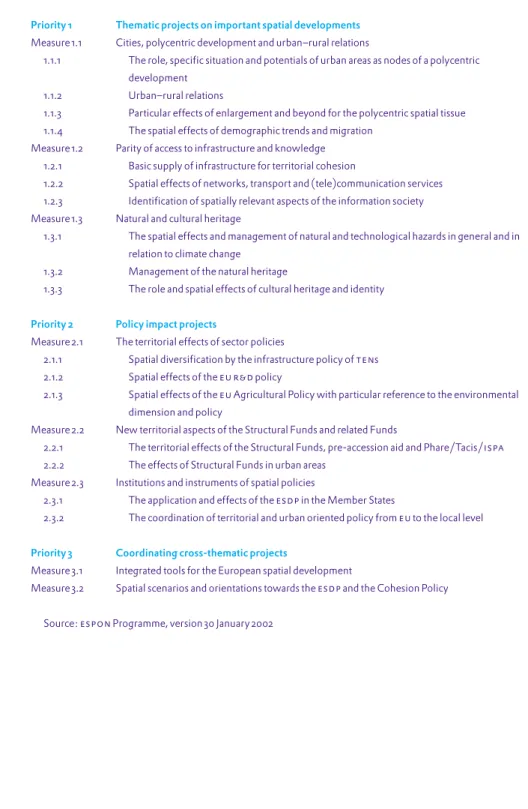
Table 1. The espon 2006 Programme
Priority 1 Thematic projects on important spatial developments Measure 1.1 Cities, polycentric development and urban–rural relations
1.1.1 The role, specific situation and potentials of urban areas as nodes of a polycentric development
1.1.2 Urban–rural relations
1.1.3 Particular effects of enlargement and beyond for the polycentric spatial tissue 1.1.4 The spatial effects of demographic trends and migration
Measure 1.2 Parity of access to infrastructure and knowledge 1.2.1 Basic supply of infrastructure for territorial cohesion
1.2.2 Spatial effects of networks, transport and (tele)communication services 1.2.3 Identification of spatially relevant aspects of the information society Measure 1.3 Natural and cultural heritage
1.3.1 The spatial effects and management of natural and technological hazards in general and in relation to climate change
1.3.2 Management of the natural heritage
1.3.3 The role and spatial effects of cultural heritage and identity
Priority 2 Policy impact projects
Measure 2.1 The territorial effects of sector policies
2.1.1 Spatial diversification by the infrastructure policy of tens 2.1.2 Spatial effects of the eu r&d policy
2.1.3 Spatial effects of the eu Agricultural Policy with particular reference to the environmental dimension and policy
Measure 2.2 New territorial aspects of the Structural Funds and related Funds
2.2.1 The territorial effects of the Structural Funds, pre-accession aid and Phare/Tacis/ispa 2.2.2 The effects of Structural Funds in urban areas
Measure 2.3 Institutions and instruments of spatial policies
2.3.1 The application and effects of the esdp in the Member States
2.3.2 The coordination of territorial and urban oriented policy from eu to the local level
Priority 3 Coordinating cross-thematic projects
Measure 3.1 Integrated tools for the European spatial development
Measure 3.2 Spatial scenarios and orientations towards the esdp and the Cohesion Policy
Source: espon Programme, version 30 January 2002 Figure 3. Convergence of esdp principles
Source: Ministerie van vrom (1999)
Competition
Sustainability Cohesion
Polycentric dev
elopment and ne
w urban/rural rel ationship
Parity of access to infrastructure and knowledge
Wise management of na tural and c
ultural heritage
Economy Environment Society
esdp
1. As its name implies, espon refers to a network of organisations rather than a new eu institution. It is based in Luxemburg and headed by the Committee for Spatial Development (a committee consisting of one high-ranking official from each Member State in the area of spatial and regional policy) and a Monitoring Committee. The group of espon contact points (one for each Member State) takes care of the actual implementation of the programme. espon is funded through the eu Interreg iii Programme, also partly a product of the esdp. A sum of €12 million has been reserved for the required research in the 2002–2006 period (50% of which is financed by the e uand 50% by the Member States involved).
This shared competence also applies to the internal market, agriculture and fisheries, transport, energy and the environment, and means that both the eu and the Member States are authorised to act in a particular area. As in these other areas, when in doubt, the authority of the eu will take precedence as a higher tier of authority. On the other hand, this is kept in check by the subsidi-arity principle which limits the range of activities the eu may undertake:
Under the principle of subsidiarity, in areas which do not fall within its exclusive competence the Union shall act only if and insofar as the objectives of the intended action cannot be sufficiently achieved by the Member States, either at central level or at regional and local level, but can rather, by reason of the scale or effects of the proposed action, be better achieved at Union level. (i-9-3)
In short, spatial planning will remain a clear national activity as long as the eu does not infuse the term ‘territorial cohesion’ with a meaning that would enable the Union to act to promote it, and then chooses to act on this basis. Unfortunately, there is little agreement on how this rather vague concept will or should be interpreted, and it may be left to precedent to settle the issue.4 If territorial cohesion does become an eu competence, it could provide the key to a future esdp with binding force rather than voluntary adherence. The current document is already in need of an update due to the new stream of insights being provided by espon and, more importantly, the enlargement.
Enlargement
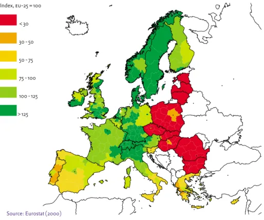
Probably the most fundamental change to the European Union in the near future will be the enlargement by ten Member States in May 2004 (cf. Figure 4). For many people this has come as somewhat of a surprise, but the processes that led to this decision have been in motion for over a decade. In 1993 the European Council, meeting in Copenhagen, agreed to establish political, economic and administrative criteria for entry into the Union; nine years later in the same city, the Council agreed on the largest expansion of the eu in its history. This enlargement is different from previous ones because all the accession countries, except the islands of Cyprus and Malta, are former com-munist countries in Central and Eastern Europe (i.e. Poland, Hungary, the Czech Republic, Slovakia, Slovenia, Latvia, Estonia and Lithuania). Negoti-ations with Romania and Bulgaria are already underway on their possible entry into the Union a few years later, which would bring the total number of eu Member States to twenty-seven, and Turkey has already expressed a keen interest in becoming the first Moslem eu Member State. The expansion, including Romania and Bulgaria, will increase the total landmass of the eu by 34 per cent and its population by approximately 105 million (cpb 2003: 24). Nevertheless, since the gdp per capita of the accession countries is only about 40 per cent of the eu average, their combined gdp is comparable to that of the Netherlands (de Mooij and Nahuis, 2003: 14). Unemployment is also higher, at about 15 per cent in 2000, which is roughly twice the eu average.
Context 22 •23
In addition to espon, the eu also finances some spatially relevant research through its Framework Programmes.2 This supports the eu’s aim, articulated at the Lisbon summit in 2000, of becoming the most competitive and dynamic knowledge economy in the world by 2010.3 The results of the research conducted under the Fifth Framework Programme are now becoming available, the most spatially interesting being those on ‘competitive and sustainable growth’ and ‘energy, environment and sustainable development’. The most relevant topic for spatial research in the current programme is ‘global change and ecosystems’, which has a budget of about 700 million Euros.
Despite the existence of the esdp and espon, the future of European spatial planning remains uncertain. There is still no formal planning subject at the European level with the authority to impose its views on unwilling Member States; everything continues to be implemented on a voluntary basis. Moreover, the eu still lacks a legal basis for spatial planning, although as the next section will show, the inclusion of the term ‘territorial cohesion’ in the Draft Constitution may imply this. The enlargement of the eu will also make many of the conceptualisations of European space in the esdp obsolete. Nevertheless, despite its non-binding status, the esdp has been influential in several relevant sectoral policy areas (Ministerie van vrom 1999; Waterhout 2002). Its importance lies not so much in the document itself, but in the forging of new alliances in European spatial planning, the introduction and acceptance of common planning concepts in the long term, and the creation of ‘an arena for a discourse on European space’ (Faludi and Zonneveld 1998a: 263).
Constitutional Convention
The unveiling of the Draft Constitution in July 2003 signals a new era in European cooperation. If adopted by the Member States, this document will arguably become the greatest milestone in the eu’s long development and cement its legitimacy as a tier of government. The creation of a constitution is seen as an essential precondition for the continued functioning of Europe after the enlargement. Although the content of the Draft Constitution continues to be debated at the eu level and in the current and future Member States (including referenda), it is expected that the main passages relevant to spatial policy will survive relatively unscathed. The stumbling blocks to the ratification encountered in late 2003 resulted primarily from disagreement over voting rights.
For spatial planners, the vital issue is what this document could mean for planning at the European level. Currently, planning is not an eu competence, nor is the current institutional arrangement of the eu equipped to handle it. This could change, however, with the inclusion of the concept of ‘territorial cohesion’ in several passages of the Draft Constitution. According to this document, one of the duties of the Union is to ‘promote economic, social and territorial cohesion, and solidarity among Member States’ (i-3-3). The draft further stipulates that the Union shares competence with the Member States in the principle area of ‘economic, social and territorial cohesion’ (i-13-2).
u n s e e n e u r o p e
4. The formal designation of territorial cohesion as an eu competence could lead to a new model for coordination: the linking of sectoral (vertical) policy areas and instruments for (horizontal) coordination of those elements that have or could have territorial effects. This is how the concept of territorial cohesion was introduced in an influential commentary on the strict sectoral organisation of the European Commission (Robert et al. 2001).
2. The Sixth Framework Programme is a subsidy instrument to stimulate scientific research in the eu. The aim is to promote a European Research Area and reduce the r&d gap with the United States and Japan through improved cooperation between European institutes. The total available budget is €17.5 billion for 2003–2006. As with many other eu programmes, Sixth Framework funds are issued according to the principle of co-financing: over half of the funds must come from other sources.
3. The strategy for achieving this includes a broad package of economic, social, environmental and research items. Further agreements have been made with national governments about such things as increasing r&d expend-itures, improving education, the Single European Sky, the reduction of obstructive regulations for small and medium-sized enterprises and i c tnetworks, and the establish-ment of a European risk capital fund for ict projects.
Not surprisingly, much of the discourse surrounding the enlargement has centred on the budgetary consequences of the weak economic position of the ten new Member States. Following their accession, these countries will have the same rights and duties as other eu countries, including the right to agri-cultural and regional cohesion support. This has prompted calls for reform in both these policy areas. An unmodified agricultural/rural areas policy would require an additional 14.5 billion Euros (the budget is currently about €40 billion), which would be in direct violation of the 2002 Copenhagen agree-ment to limit increases in expenditure to 1 per cent each year (de Mooij and Nahuis 2003: 13). Similarly, an unmodified Structural Funds policy would require an annual increase in the budget of 7 billion Euros, or 20 per cent, which is politically unacceptable to various Member States (Ministerie van bz 2001).5 In all, the enlargement will have a profound impact on the future of the eu’s two largest budgets, agriculture and regional cohesion.
Perhaps of greater importance to the future of Europe than such budgetary matters is the effect of the internal market. By eliminating trade barriers and standardising regulations throughout the enlarged Union, commerce between new and old Member States will grow rapidly. It is expected that the opening up of new markets and the introduction of foreign competition will result in an increase in scale of economic activities and specialisation. Interestingly, the relatively modern and efficient Dutch agricultural sector may stand to gain from the enlargement by supplying produce to candidate countries like Poland at a lower price than local producers can offer. Haulage and logistics companies will also profit from increased trade, while other sectors will probably suffer from the increased competition. On balance, the enlargement is expected to have a minor but positive impact on the Dutch economy. Another aspect of the internal market, the right of citizens to free movement, is expected to increase migration in the eu, although predictions of the number of migrants from new Member States vary widely (from 1 to 13 million). Generally it is expected that relatively few (1%) will settle in the Netherlands; unless one considers the possible accession of Turkey (de Mooij and Nahuis, 2003: 19; cpb 2003: 34–38).
It is important to note that changes in the economic structure of Europe can affect the spatial structure and demography as well. The enlargement of the eu with ten new Member States in 2004, and in all probability two more soon after, will have far-reaching implications for eu spatial policy (insofar it exists). Since the esdp is the outcome of discussions between the fifteen Member States it will obviously be inadequate for a 25/27-member Union. The enlargement will alter the physical area of the eu, changing urban–rural relationships and creating new border regions. It will also have massive consequences for transport. Finally, the enlargement will bring with it new environmental and economic development challenges, which are discussed in detail in the Chapters on ‘Environment and nature’ and ‘Regional Policy’ respectively.
Context 24 •25
5. Since Southern European countries would stand to lose most of their funding, they may seek to lower the Objective 1 threshold in order to continue to receive aid. Other net contributors, the Netherlands included, may seek to reduce their contributions.s
u n s e e n e u r o p e
Figure 4. Enlargement of the eu and gdp per capita, 2000
Source: Eurostat (2000) Index, eu-25 = 100 < 30 30 - 50 50 - 75 75 - 100 100 - 125 > 125 Conclusions
The eu is an ever-changing construct, evolving from the one treaty to the other and continually finding new competences to legitimate its existence; including it would seem, spatial planning. At the same time, the eu is also an entity on the brink of an institutional rebirth: a new Constitution, a brave expansion eastwards, and the ambition to become the world’s best knowledge-based economy. While so much seems uncertain and open, eu policy continues to resonate and affect spatial developments in the Member States in a variety of distinct ways. In some areas, the influence of Brussels will increase, while in others it will diminish. It is the task of this survey to take stock of the spatial impact of eu policy in the Netherlands, not just now, but in the light of the sweeping changes discussed in this chapter.
The following chapters will take a closer look at how sectoral eu policies affect spatial developments in the Netherlands. The topics chosen reflect those in the spatial planning literature (e.g. Committee on Spatial Development 1999; Robert et al. 2001; Tewdwr-Jones and Williams 2001; Vet and Reincke 2002) and fall more or less into the categories of ‘carrots’ and ‘sticks’: they attempt to effect change either by providing positive stimuli, such as subsidies and
information, or by imposing restrictions (cf. van Schendelen 2002). Although a combination of both strategies is employed most of the time, the first three topics (regional policy, transport and agriculture) generally gravitate towards the ‘carrot’ approach, while the latter three topics (competition, environment and water) rely more on ‘sticks’ to bring about change. A third kind of policy instrument, persuasion via coordination and information (‘name and shame’), is usually used in combination with the ‘sticks’ approach and is more prominent in later chapters.
u n s e e n e u r o p e
r e g i o n a l p o l i c y
Introduction
Although the European Union does not have the formal competence to engage in spatial planning, it is our conviction that its sectoral policies do have a clear impact on land use and development in the Member States. The most obvious example is the eu’s regional policy which, under the banner of ‘cohesion,’ seeks to mitigate socioeconomic disparities between European regions. By channelling funds to projects such as roads, bridges and office parks, the physical impacts of eu regional policy are readily discernable. eu regional support in the form of ‘place-based’ subsidies and retraining programmes can also produce shifts in investments over space, although the effects of this cannot be observed directly.
In this chapter we first map out the basic framework of eu regional policy and its most important instrument, the Structural Funds, including an overview of the funding levels for the various programmes. We then examine how these funds have affected spatial developments and the way planning is done in the Netherlands. We conclude with a discussion on the changes to eu regional policy now underway and their ramifications for the Netherlands.
eu policy
In the early years of European cooperation, most of the participating countries had roughly the same level of national economic development, but there were greater disparities between the regions within them. To live up to its commit-ment of providing a level economic playing field, Europe embarked on a regional policy to reduce these disparities. As early as 1958, the European Social Fund (esf) and European Agricultural Guidance and Guarantee Fund (eaggf) were set up to soften the harsher effects of the common market. With the entrance of Britain to the European Community in 1973, the problem of economic restructuring became apparent, and the vastly important European Regional Development Fund (erdf) was established to address this problem. Later, when Greece (1981), Spain and Portugal (1986) joined the ec, disparities in income levels were no longer restricted to regions within countries but also existed between Member States. The Cohesion Fund was set up to enable the new Member States to catch up. At the end of the 1980s, the various regional funds were reorganised and renamed the Structural Funds, which are administered according to a programme of roughly five years. The budget was also increased.
The first Structural Funds period (1989-1993) saw the inclusion of cohesion as one of the primary objectives of the European Union in the Maastricht Treaty,
Effects of regional policy in Europe
There is widespread disagreement about the effects of eu cohesion policy and the effectiveness of the Structural Funds in particular. Since the introduction of the regional policy, economic disparities between Member States have notably declined, yet they have remained about the same between regions, and actually increased within Member States (de Vet and Reincke 2002). This strange development leaves much room for interpretation. Although evaluations by the European Union have been (unsurprisingly) positive (e.g. European Commission 2001a: 30), there are some who argue that regional policy has had little or no effect (de Mooij and Tang 2002). Others are even more pessimistic, arguing that the Structural Funds work counterproductively. These authors claim that regions will eventually converge as a result of general economic development and that the cohesion policy, by dampening this through reallocation, can inhibit this natural cohesion process. Other arguments against the deployment of Structural Funds are that:
– they crowd out private sector investments instead of stimulating them; – they reward Member States for neglecting regional disparities in their own countries;
– the bureaucratic burden of the rules imposed in the allocation of funds dampens economic stimulation;
– political manoeuvring has created a ‘money go round’ in which many funds circulate among wealthier Member States;
– deploying regional funds for new infrastructure can lead to environmental damage and expose sensitive economies to fierce competition.
In short, the Structural Funds, stretched by attempts to obtain political support for the eu among the wealthier Member States, are accused of having become an unwieldy and ineffective instrument for achieving economic and social
Regional Policy 30 •31
and a corresponding budgetary increase to ecu 68 billion (1997 prices). In the second Structural Funds period (1994–1999) the budget more than doubled to almost ecu 177 billion. The third and current Structural Funds period (2000-2006) has the largest budget to date. Regional policy now comprises over 35 per cent of the total eu budget and is second only to agriculture in terms of expenditure (Ederveen et al. 2002). Despite this phenomenal growth, the Structural Funds budget still is only about 0.45 per cent of total eu gdp (currently the total eu budget is around 1 per cent, with an official ceiling of 1.27% of total gdp). Table 2 provides an overview of the total expenditure on cohesion policy for the current period.
As Table 2 shows, the majority of eu funding (70%) is targeted at regions whose development is lagging behind (Objective 1), a further 11.5 per cent is earmarked for economic and social restructuring (Objective 2) and 12.3 per cent of the funding is directed at promoting the modernisation of training systems and job creation (Objective 3). In addition, the eu provides funding for the adjustment of fisheries outside Objective 1 regions (0.5%) and innovative actions to promote and experiment with new ideas on development (0.51%). Community Initiatives (5.35%) address specific problems, including:
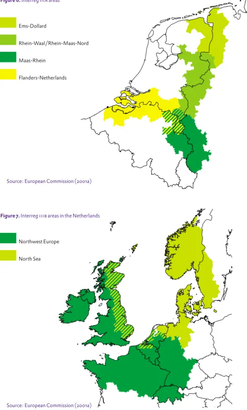
– cross-border, transnational and interregional cooperation (Interreg i i i) – sustainable development of cities and declining urban areas (Urban i i) – rural development through local initiatives (Leader+)
– combating inequality and discrimination in access to the labour market (Equal).
In addition to the Structural Funds, the Cohesion Fund provides direct finance for specific projects relating to environmental and transport infrastructure in Spain, Greece, Ireland and Portugal; the Instrument for Structural Policies for pre-Accession (i s pa) provides assistance along the same lines to the ten countries joining the eu in 2004.
u n s e e n e u r o p e
Table 2. Regional policy budget for the current period
euRegional policy Total budget for the 2000–2006 period (in 1999 euros) Structural Funds
– Objective 1 135.90 billion – Objective 2 22.50 billion – Objective 3 24.05 billion Community Initiatives 10.44 billion
Fisheries 1.11 billion
Innovative actions 1.00 billion Regional funds total 195.00 billion Cohesion Fund 18.00 billion Total regional policy 213.00 billion
Source: European Commission (2002c)
Obtaining funding: the process
The allocation of eu funds is a complex process involving various tiers of government. According to the current process, the budget and goals for the upcoming period are set by the European Council. Member States can draw up programme proposals and submit them to the Commission for review. In the review process, the eu assesses proposals against a funding condition of additionality: applicants must argue that the project would have not been feasible or carried out without extra Community support. To ensure that the projects funded by eu money have merit or promise, the eu also requires that they are
co-financed by thae public and/or (preferably in terms of leverage) the private sector. Together, these measures seek to ensure that eu support provides that critical ‘push over the edge’ to ensure that worthwhile projects are carried out. In the next stage, the programmes are discussed and implementation strategies and funding levels are designated. Deciding on the actual projects to be funded within the framework of the programmes is a matter for decentralised authorities and their partners. However, they are still monitored for compliance with eu objectives and effectiveness according to eu defined criteria.
as Greece and Spain, which have received more regional funds for physical infrastructure such as roads and railways (de Vet and Reincke 2002: 14). Much of the aid received by the Netherlands takes the form of support for training programmes or research and coordination under Interreg rather than physical infrastructure. Besides, in more affluent nations like the Netherlands, support via the Structural Funds is not only likely to be less extensive and manifest, but also raises the important issue of whether the developments would have occurred without eu support anyway (this is, of course, true to a certain extent for all Structural Funds recipients): the Structural Funds mainly assist the implementation of planned projects rather than generating completely new ones. This section examines the various ways the eu has invested in the development of the Netherlands in the framework of its regional policy, focusing on the previous and current Structural Funds periods.
Previous period: 1994-1999
According to an evaluation of the 1994-1999 Structural Funds period in the Netherlands, European funds were found to have contributed to a significant overall drop in unemployment in the targeted areas (erac 2003: v). This has been attributed to successful stimulation programmes co-financed by the eu, but we cannot confirm this because we do not know for certain what would have happened in these regions without eu support. A comparison with non-supported regions, performed by erac, revealed a mixed picture: in some sectors unsupported regions outperformed supported regions, in others they were similar, and in still other sectors, regions receiving eu aid outperformed non-supported regions. Regarding the last group, the eu funds that seem to have had the most positive effect were for transport, storage and communi-cation projects. More importantly in a spatial sense, regions enjoying eu support allocated more land (in both absolute and relative terms) to the development of business parks (erac 2003: 29). One should, however, be cautious in drawing conclusions from the results of this kind of research because it is difficult to compare regions with different growth rates. More-over, the question remains whether the Netherlands would have supported these areas anyway without eu aid.
The effects of eu policies are more readily discernable when they diverge from national policy. In this sense, the effect of eu regional policy is perhaps more evident in the Netherlands than other ‘wealthy’ Member States because it does not exactly match national spatial economic policy. In fact, the very concept of cohesion, far from being an exciting new policy frontier, seems somewhat of an anachronism in the Netherlands: it resembles national planning of three decades ago (Faludi and Zonneveld 1998a).
Nowhere is the disparity in policy objectives more visible than in the province of Flevoland, the only Objective 1 region in the Netherlands during the 1994-1999 period (and receiving phasing-out funds in the current period). The region was awarded Objective 1 status not because it was so backward, but because it simply met the requirements for having a low g d p per capita. Many Flevoland residents commute to other areas (mainly to Amsterdam) for work and, in the eyes of the eu, this means that economic production in the province
Regional Policy 32 •33
cohesion and potentially causing environmental damage – not to mention generally violating the subsidiarity principle.
Partly in response to this criticism, reform of the Structural Funds has been high on the European agenda. As indicated in the previous chapter, the discussions are also framed by several major institutional developments. The enlargement of the eu has raised fears among current Member States about the cost of an unmodified regional policy. After the enlargement, regional disparities in the e uwill nearly double and a continuation of the Structural Funds under the current system would require a budget of approximately 360 billion Euros for the 2007–2013 period (Redeker 2002: 593). In this scenario, ‘net-payers’ like the Netherlands would find themselves obliged to contribute even more, whereas countries like Spain and Portugal would lose a substantial amount of the aid they enjoyed in previous Structural/Cohesion Fund programmes. Although not official policy, the institutionalisation of European spatial planning (the esdp) has already affected the allocation of the Structural Funds by drawing attention to the importance of territorial coordination. Another issue concerns the implications of the inclusion of ‘territorial cohesion’ in the Draft Constitution: it remains to be seen which interpretation of this contested concept will prevail, but if it is endowed with sufficient meaning, it may serve as one of the guiding principles for the reform of the eu’s regional policy. If the European Union really is determined to become the most dynamic and competitive knowledge-based region in the world, as agreed at the European Council Lisbon summit in March 2000, it may have to rethink some of its investment priorities, particularly the philosophy of channelling support to weaker regions rather than those with high economic potential. All these issues have made the future of the Structural Funds highly contentious.
A first statement by the Commission on regional policy in the 2007–2013 period was made in the long-awaited Third Report on Economic and Social Cohesion, published on 18 February 2004. Here, we can already see which forces seem to have prevailed in the latest rounds of negotiations. As expected, much of the attention of the report is devoted to ameliorating the disparities between cur-rent Member States and the accession countries. The most substantive change to the Structural Funds is the replacement of numbered Objectives with Community priorities. The priority ‘convergence’ resembles Objective 1 and is directed to the economic and social cohesion of regions in the eu. The priority ‘regional competitiveness and employment’ resembles Objectives 2 and 3 but with more stress being placed on the ideals articulated in the Lisbon strategy. Finally, space plays an enhanced role in the new report, with Urban, Equal, Leader+ and especially Interreg being elevated to the status of the Structural Funds Objective ‘European territorial cooperation’ (European Commission 2004a). Again, as in all preceding periods, the budget is being increased substantially, to about 384 billion Euros (European Commission (2004b).
Consequences for the Netherlands
It is hard to measure the exact spatial impact of eu regional policy in the Netherlands. Its effect is obviously less visible than in cohesion countries such
pattern, with the Objective 2 and 5b areas from the previous period often (but not always) corresponding to Objective 2 areas in the current period.2 A notable difference is the addition of cities such as Amsterdam in the current period.
Objective 1: Flevoland
As mentioned above, the province of Flevoland qualified for Objective 1 status in the 1994–1999 period, and thus for phasing-out funding in the current period. The total budget for the programme is 471 million Euros, of which 126 million Euros is contributed by the eu and about 15 per cent from the private sector (European Commission 2003a). The stated goals of the projects funded by eu regional policy include the development of rural and urban areas, strengthening the production sector, social cohesion and technical support. In the city of Almere alone, about twenty current projects have received eu funding (about 10% on average). Examples include a World Trade Centre, various walking routes, two railway stations and regeneration of the harbour with space provided for artists. The programme includes the construction of Kamer 2002: 9).
Regional Policy 34 •35
is comparatively low. Consequently, the programmes submitted for eu focus on job creation within the province, partly through the construction of new business parks. Joke van den Brink, programme manager for European subsidies in Flevoland, estimated that eu assistance resulted in 25,000 extra jobs in the province. In addition, eu funding allowed the Eemnes a27/a6 motorway interchange (Almere Buiten) to be completed fifteen years ahead of schedule (Boiten and Van der Sluis 2000). Thus, if we attribute the growth in jobs in the Flevoland Objective 1 region in part to the efforts of the European Union, and factor in the additional capacity provided by the a27, one could argue that the main roads out of the region are less congested than they would have been without eu support.
Spatial effects in other regions in the 1994-1999 period include the co-financing of the n391 road in Drenthe, which redirects through traffic around the sensitive villages. Like Eemnes, this was primarily a matter of time: the project had been on the table since 1985, but was only started once it received e ufunding in 1998. Other examples include support for a plant specialised in sieving powders in Limburg, a public transport shuttle service in the Noord-oostpolder, the 2100 ha nature reserve ‘Gelderse Poort’ in Gelderland and rural tourism in Drenthe (European Commission 2001b).
Current period (2000-2006)
Until about 1990, the Netherlands was a net recipient of European funds, but since then the Dutch position has gradually worsened (Ministerie van bz 2002: 48). Whatever benefits the Netherlands may gain from the Structural Funds, agricultural policy and other support it receives, the fact remains that this in no way compensates for Dutch contributions. At present, the Netherlands is the largest net contributor to the eu.1 In the next Structural Funds period (2007–2013) the Netherlands will receive no Objective 1 (i.e. convergence) funding at all and levels of Objective 2 and 3 (i.e. regional competitiveness and employment) funding may also fall as a result of positive employment development in relation to other eu countries (erac 2003: 39). This may help to explain the Dutch Government’s current stance of targeting eu regional policy funds to the poorest Member States, rather than allowing them to circulate among the wealthier countries as well.
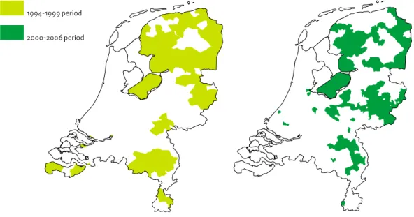
It is interesting to note that over half of all the Structural Funds received by the Netherlands in this period were for the Objective 3 programme. Since Objective 3 is not area-based, its spatial effects, along with some Community Initiatives like Equal, are difficult to trace. The maps in Figure 5 show the regions receiving area-based Structural Funds in the previous and current periods. These maps should still be read with caution: although the investment of funds into a particular area is bound to have spatial effects, it is extremely difficult to determine the exact extent of this effect, especially when the programmes have economic rather than spatial goals. Nonetheless, the difference in designation criteria are immediately apparent: the Objective 1/ phasing-out region of Flevoland corresponds to established administrative boundaries, while the other Objective designations show a more scattered
u n s e e n e u r o p e
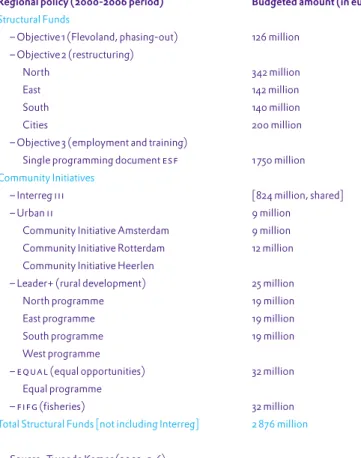
Table 3. Structural Funds received by the Netherlands
Regional policy (2000-2006 period) Budgeted amount (in euros) Structural Funds
– Objective 1 (Flevoland, phasing-out) 126 million – Objective 2 (restructuring)
North 342 million
East 142 million
South 140 million
Cities 200 million
– Objective 3 (employment and training)
Single programming document esf 1 750 million Community Initiatives
– Interreg iii [824 million, shared]
– Urban ii 9 million
Community Initiative Amsterdam 9 million Community Initiative Rotterdam 12 million Community Initiative Heerlen
– Leader+ (rural development) 25 million
North programme 19 million
East programme 19 million
South programme 19 million
West programme
– equal (equal opportunities) 32 million
Equal programme
– fifg (fisheries) 32 million
Total Structural Funds [not including Interreg] 2 876 million
Source: Tweede Kamer (2002: 5-6) 1. This is not merely a reflection of
the relatively affluent position of the country, as the even more affluent Luxembourg is the largest net recipient of eu funds (Ministerie van BZ 2002: 47). However, in general, if the wealth of eu regions are empirically set against the levels of eu support they receive, a clear negative relationship is discernable (De Mooij and Tang 2002: 12).
2. Unlike Objective 1 areas, Objective 2 status is awarded to defined areas, which are usually not consistent with administrative boundaries.
general, the ‘Kompas’ was found to be effective in stimulating economic development and all participating provinces have seen rapid growth in tourism.
There has been some criticism, though. By lowering development costs, eu subsidies may also remove the incentive for intensifying land use, resulting in lower densities in business parks. The workings of the real estate market itself can even be disrupted: although the intention is to attract businesses from outside the region, local businesses can simply relocate to the subsidised parks, leaving empty offices behind. Even when this is not allowed, artificial
overproduction can threaten the viability of new parks. A case in point is the International Business Park Friesland. This park was developed with generous public funding (including eu Structural Funds) to attract multinational businesses to the region, but the only occupant (the computer assembler s c i) has since shifted its operations to Eastern Europe. Since the eu has decided not to demand repayment of its subsidies if the park is sold off in parcels to smaller businesses, the municipal council is now considering this option. A probable consequence is that the park would no longer be in a position to fulfil its original purpose of attracting international businesses.
Objective 2: East Netherlands
The programme for the eastern part of the Netherlands covers the provinces of Gelderland and Overijssel and part of the province of Utrecht. These provinces began lobbying for eu funds for the regeneration of problematic urban areas at the beginning of the previous Structural Funds period (1994). Although the emphasis lay in the economic sphere, the programme had a spatial component, which consisted mainly of the construction of new business parks and other development opportunities associated with the ‘Betuwelijn’, the dedicated freight-only railway line from Rotterdam to Germany.
In the current period, rural restructuring was successfully added to the programme; both here and in Zuid Nederland, intensive livestock farming must be reduced to meet eu nitrate standards (see the chapter on ‘Water’). The construction of the multimodal transport terminals in Arnhem–Nijmegen and Twente, with eu financial aid, will have potentially large spatial effects by virtue of the physical construction itself and also by attracting related industrial activities (Boiten and van der Sluis 2000). In addition, a centre for sustainability in Zutphen is being supported with eu funds. eu funds are also being used to co-finance tourist activities, such as a pier for cruise ships on the Pannerdensch canal, walking routes on church paths and the renovation of a historic courtyard at Doornenburg Castle. In total, the region stands to receive 141 million Euros in e ufunding towards its 391 million Euros budget for economic diversification.
Objective 2: South Netherlands
Limburg was early in lobbying the eu for development funds, receiving 40 million Euros in the first Structural Funds period and 100 million Euros in the second. Projects co-funded by the eu include ‘Toverland’ in Sevenum, the ‘Mijn op Zeven’ tourist centre in Ospel, a container terminal/industrial area in Holum, the ‘Mondo Verde’ theme park in Kerkrade and the ‘Bassin’ marina in
Regional Policy 36 •37
Figure 5. Areas receiving Structural Funds aid in previous and current periods
Source: erac (2003)
Objective 2: North Netherlands
The ‘Kompas voor het Noorden’ programme covers the three northern provinces of Drenthe, Friesland and Groningen. The primary goal is to bring the level of economic development (measured in jobs) in this region into step with the rest of the country. The eu funds for this programme are derived from various sources: Objective 2, phasing-out of Objective 2/5b programmes, Objective 3, funds from the eu agricultural policy, Leader+ and Interreg i i i a (s n n 2003: 11). Like many other Dutch programmes using Structural Funds, many of the effects are not directly reflected in changes in land use. Of the spatial effects, the most noteworthy are the development of business parks, the construction of infrastructure for recreational ends (cycle paths, nature trails and water routes) and the preservation of historic monuments. The programme makes provisions for the addition of 230 ha of new business parks in the current period (Tweede Kamer 2002: 9).
In 2003, the consultancy firm Ecorys conducted a midterm review of this programme. Although the criteria primarily relate to economic development, some spatial implications can be assumed as well. In view of the causality problem, Ecorys considered the developments that would not have occurred without the assistance of the ‘Kompas’ programme. Roughly speaking, these are ‘the initiation of important developments which are not taken up when more urgent, but less important, matters are given priority within the regional budgetary parameters’ (Ecorys 2003: 15). Specific projects include investments in knowledge and it infrastructure, the Frisian ‘Merenproject’ for water recreation and the prestigious ‘Blauwe Stad’ residential development. In
u n s e e n e u r o p e 1994-1999 period