1. Introduction
A recent addition to the burgeoning vocabulary of Euro-English, the ‘language’ used by civil servants and politicians operating with or within European institutions (Williams, 1996), is the term ‘territorial’. Although the conceptualization of the word is actually no different than its common dictionary definition – “of or relating to the geographic area under a given jurisdiction” (online dictionary) – the ways it is currently being used to qualify policy terms is noteworthy. The Treaty on the European Union has, since Amsterdam (1997), contained the term ‘territorial cohesion’ and since Lisbon (2007) identified this as an objective of the European Union. The OECD and others use the term ‘territorial capital’ to denote various assets and characteristics of regions, the European Commission claims that ‘territorial diversity’ is an asset of the EU and provides funding to promote ‘territorial cooperation’. Member states have taken the initiative to draw up a ‘Territorial Agenda’ based on a ‘Territorial State and Perspectives of the European Union’. Finally, Territorial Impact Assessment (TIA) is being promoted as a way to improve policymaking.
Like other policy analysis and evaluation tools, TIA seeks to determine the impacts of projects or policies. What makes TIA novel is its large-scale approach (usually one or more regions at a time), its multidimensionality and the broad range of impacts considered (Torrieri and Nijkamp 2009). Its origin lies in the desire to address sometimes unexpected and contradictory impacts of European policies such as the Common Agricultural Policy (CAP), transport policy, and environmental policies, within or on particular regions. The European Union has no formal authority in the area of urban and regional planning – or ‘competence for spatial planning’ in Euro-English – to ensure that its many regulations, directives and funding policies are cohesive when they are applied at the ground level. This lack of coordination can lead to problems for local or regional territorial authorities, or at the very least entail opportunity costs for synergy (Robert et al. 2001). The argument is that by knowing the territorial impact of a policy, and how it interacts with other policies beforehand, one can avoid the costs of non-coordination.
The European Spatial Development Perspective (ESDP), an informal policy document signed by European ministers of spatial planning in 1999, initiated a debate within the
a critical examination of
current practice
small and tight-knit European spatial planning community on TIAs “as an instrument to coordinate the spatial impacts of sector policies (horizontally) as well as across different levels of governance in the EU (vertically)” (Dühr et al. 2010, p. 230). Even within this community, not everyone agrees that TIAs are necessary, or even desirable. The level at which a TIA should take place is also the subject of debate: it could be performed by the European Commission before formulating a policy proposal, by member states in their reaction to this proposal, or even by regions dealing with implementation.
At present, there is no consensus on a definition of TIAs (Zonneveld and Waterhout 2009, p. 3). The scope of a TIA has been both narrowly and widely defined. Böhme and Eser (2008) take the broader view, stating “[i]n principle, TIA includes all aspects of spatial planning, the prospective and comprehensive shaping of a certain area by means of plans, as well as the ad hoc evaluation of projects as regards their effects on spatial structures. At a certain point the necessity of distinguishing between the terms territorial impact analysis for policies and territorial impact assessment for programs and projects was discussed; it appears that in a policy context, the literature, and daily practice, however, the term territorial impact assessment is used for both” [emphasis in original] (p. 43). This contribution follows the latter and broader conceptualization of TIAs as regards the object of study, and widens the scope even more as it pertains to methodology. Obviously, since there is no agreement on a definition, there is even less consensus on a common methodology for TIAs. Nevertheless, since the scope is generally large-scale (often the entirety of the European territory) and the effects multidimensional, certain analytical techniques are more common than others in TIA practice.
This contribution will take a critical look at TIA as an emerging method in policy analysis. It starts with a retrospective of the political debate on TIAs, which is embedded in the discussion on European spatial planning and territorial cohesion. The second part provides an overview of the methodology, ranging from TIA antecedents to state-of-the art TIA developments at both the European and member-state level. Afterwards, the case study of the Netherlands will be examined in detail, as it was – and remains – a vocal advocate of TIAs. Finally, a reflection will be made regarding the relative need for TIAs in the future.
2. Review of political discussion on TIAs
Although the need for policy impact studies, including those measuring unintended effects of policies, have existed almost as long as policy analysis itself, the call for TIA reflects some new concerns. On the one hand, there is a perceived need to gain information on policy effects within an increasingly fragmented public sector and complex and increasingly multilevel and multiscalar policy environment (Brenner 2004). This need stems from a desire to decrease uncertainty within a ‘risk’ society increasingly preoccupied with the future (Giddens 1999, p. 3). In this sense, TIA more than simply an ex ante evaluation of policy instruments: it also provides a glimpse into complex relations between economy, society and the environment and the relative effect of public policies on these dimensions. For this reason, TIAs are often carried out within or in conjunction with scenario exercises (Torrieri and Nijkamp 2009). This is a novelty in
relation to its predecessors, which were mainly focused on measuring impacts in a more narrow sense.
2.1. ESDP process
Policy coordination and territorial impacts are a longer concern in European politics. Already in the early 1980s, DG Regio commissioned a number of studies to investigate the impact of other European policies on the main goal of regional policy: reduction of socioeconomic disparities in terms of GDP/inhabitant. Particularly the CAP was found to have a detrimental impact in this regard (see also ESPON 3.2 Vol. 5 2006, p. 13). Still, while TIAs in various guises had been discussed and actually performed under different names, TIA as a concept emerged only in the 1990s in the context of informal biannual meetings of European ministers of spatial planning. Since these meetings, and the ongoing activities in between, led to the production of the European Spatial Development Perspective in 1999, this is sometimes referred to as the ‘ESDP process’.
In the ESDP process, some countries, especially those with a ‘comprehensive integrated approach’ to spatial planning, began to insist on some kind of horizontal coordination of EU policies (Waterhout 2008, p. 107) feeling that spatial planning at the European level was, if not inevitable, at least desirable. In 1990, for example, the Dutch spatial planning agency RPD boldly announced in their annual report that: “the Dutch government is striving to have spatial planning earn a fully recognizable place in daily EU policymaking” (Martin 1990, p. 111). Although some spatial visions were produced in the course of the ESDP process, an EU policy map proved politically unattainable: the ESDP would in no way resemble a ‘masterplan’ (Faludi and Waterhout 2002). Instead, the ESDP unveiled three general principles for spatial planning (i.e. development of a balanced polycentric urban system and a new urban-rural relationship, securing parity of access to infrastructure and knowledge and sustainable development, prudent management and protection of nature and cultural heritage) and pointed to good practices in spatial planning (CEC 1999). Concerning the latter, the document included sixty specific policy options, some of which are related to TIAs. The ESDP argued, for example, that “in the future, Territorial Impact Assessment should be the basic prerequisite for all large transport projects” (policy option 29) as well as for the preservation and development of natural heritage (policy option 42) and large-scale water management projects (policy option 52). In particular, the ESDP recommended TIAs in cases of cross-border projects (ESPON 3.1 2004, p. 428).
The fairly narrow application of TIAs as suggested in the ESDP was quickly broadened to European sector policies in general (Böhme 2004, p. 186). Since the ESDP was an informal document, it could not be implemented into national legislation like a directive, but would have to be voluntarily ‘applied’ by the ministers who had helped draft it. The strategy on how to bring this about, the ESDP Action Plan, was signed in Tampere six months after publication of the ESDP. This document stated that: “The development of a common concept for Territorial Impact Assessment (TIA) is necessary to support spatial development policies. The concept shall be of a cross-sectoral nature and include socio-economic, environmental and cultural indicators for the territory in question” (quoted
in Camagni 2009, p. 343). The TIA was taken up by the ESDP authors and a special informal sub-committee in 2000, who defined TIA as “a tool for assessing the impact of spatial development against spatial policy objectives or prospects for an area”, working at “any spatial scale” and therefore applicable to large projects, plans and programmes (ECTP/CSD 2001, quoted in ESPON ARTS 2010, p. 17).
At the same time, the notion of TIAs found some support within the European Parliament. A parliamentary response to the ESDP argued for setting up a taskforce within the European Commission to carry out a so-called Strategic Spatial Assessment. The SSA would be “a multifunctional procedure for spatial and environmental analysis, that can be followed with regard to both the structural funds and to other spatially relevant formal decisions (e.g. with regard to TEN-Ts and cohesion funds)” (Stumm and Nötzel 1998, p. 27).
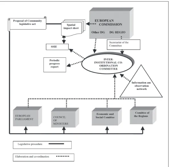
At the European Commission, DG Regio continued to support increased coordination. A report commissioned by DG Regio on the costs of non-coordination of EU policies found that the coordination problem was largely a product of the institutional structure of the EU: “[T]he progress of European integration and the deepening of common policies which resulted from it were expressed in hyper-specialisation of functions and competences within the Community authorities, and in particular within the Commission. One can observe this specialisation not only at the level of each Directorate-General, but also at the level of each direction, of each unit and even at the level of groups of officials or of individual officials” (Robert et al. 2001, p. 155). Following the recommendations of the European Parliament, Robert et al. (2001) suggested setting up a Strategic Spatial Impact Procedure (SSIE) to be carried out in early phases of policymaking by an inter-institutional Coordination Committee with a secretariat in DG Regio (pp. 158-160). The study also recommended that, “the drafting of a ‘spatial impact sheet’ should become obligatory for each service drawing up proposals for Community legislative acts” (p. 160), which is, in essence, a TIA.
In the same year as this report, the European Commission produced its White Paper on Governance. Although no mention was made of the Robert et al. (2001) report in the White Paper, policy coherence featured prominently in this document with respect to “an increasing number of horizontal policy challenges including better regulation, gender equality, environmental sustainability and of course territorial policy” (Schout and Jordan 2007, p. 836). The White Paper does not address TIAs by name, but comes close to this by stating that, “The territorial impact of EU policies in areas such as transport, energy or environment should be addressed” (CEC 2001, p. 13). So, again we see the concern with different dimensions of impact. It also calls for an “effective analysis of whether it is appropriate to intervene at EU level and whether regulatory intervention is needed. If so, the analysis must also assess the potential economic, social and environmental impact, as well as the costs and benefits of that particular approach” (CEC 2001, p. 20). Still, the Commission did not go into further detail about how to do this, unlike the suggestion of the European Parliament for a taskforce to carry out SSAs. Instead, the next year, the Commission drafted guidelines for a so-called Impact Assessment, which will be discussed in the next section on TIA methodologies.
Figure 1. Proposal of Strategic Spatial Impact Procedure (SSIE)
Source: Robert et al. (2001), p. 164.
2.2. TA process and beyond
The runner-up to the ESDP was the Territorial Agenda, which, like the ESDP, was an informal document signed by the European ministers of spatial planning following a series of biannual meetings. During this process, which took place from approximately 2004 to the present (the Territorial Agenda was revised in 2011), the subject of the need for an ‘evidence base’ was discussed extensively (Schön 2009). One of the perceived problems of the ESDP was that it lacked sufficient scientific backing for its conceptualization of European space and effectiveness of policy instruments. In 2002, the ESPON programme was set up to provide this information. Following up on the recommendations of the ESDP Action Plan in 1999, ESPON was assigned the task of further developing the TIA. Since that time, ESPON has produced a number of reports which could be described as TIAs and has actively worked on fleshing out a TIA methodology (which will be discussed in the next section).
The first versions of what was to become the Territorial Agenda were produced in 2004-2005 during the Dutch and Luxembourg presidencies. Although the substantive issues discussed at the ministerial meetings were very similar to those leading up to the ESDP, this was now being done under the banner of ‘territorial cohesion’ rather than ‘spatial planning’, as the former term had found its way into the draft (Constitutional) Treaty as a formal objective of the European Union (Faludi 2006). Using the name Territorial Policy Integration, this document refers to the need “…to integrate the territorial dimension into EU policies with the aim of achieving a coherent approach to the development of the EU territory, on the basis of the concept of territorial cohesion” (Luxembourg Presidency 2005, p. 1). The debate on territorial cohesion also included the idea of fairness across regions, not just efficiency costs. From this perspective, policies emerging from European institutions should be assessed to prevent “negative effects on regions or unnecessary unbalances” (Schout and Jordan 2007, pp. 838-9).
In the course of the Territorial Agenda process, the status of TIAs has shifted (Böhme and Eser 2008, p. 44). Although TIA did not appear in the 2007 final text of the Territorial Agenda itself (although it was mentioned in drafts), it did resurface in the First Action Programme for the Territorial Agenda six months later under the Portuguese Presidency. One of the concrete action points of this Action Programme was to gain more insight into how member states and regions assess the territorial impacts of EU policy and “to stimulate the Commission to add territorial notions into the existing impact assessment system for all EU policies” (Padulosi 2008, p. 2). The Netherlands volunteered to take up ‘Act 2.2.’ of the Action Programme: “Scope the territorial impacts of selected sectoral policies together with sectoral policymakers and jointly analyse the introduction of territorial impact assessment in the policy process” (Portuguese Presidency 2007, p. 13).
A year later, the Dutch hosted a seminar in Amsterdam to exchange best practices regarding territorial assessments, and issued a questionnaire to member states about national practices, the results of which will be used in the next section on methods. As the decade drew to a close, the intergovernmental political process surrounding TIAs seemed to fall into a hiatus. A few months after the Amsterdam seminar, the Commission issued its long-awaited Green Paper on territorial cohesion and, rather than making a firm statement on the topic, initiated a pan-European discussion. The arrival of the economic crisis, European elections and the launch of Europe 2020 overshadowed the Territorial Agenda process of the member states.
The process seemed to pick up in 2010. The Commission’s fifth Cohesion Report called attention for “better knowledge of the EU in territorial terms and more robust ways of estimating the impact of EU policies” (CEC 2010, p. 24), and cites some data improvements being made in this regard. In 2011, the Territorial Agenda was revised in order to bring it in line with the Europe 2020 strategy. The ‘Territorial Agenda 2020’ brought with it more emphasis on TIAs than the 2007 document. Again, the document does not mention TIA by name but comes very close: “[t]erritorial coordination should be supported by instruments such as assessment of territorial impacts, coordinating planning mechanisms and territorially sensitive monitoring” (TA2020 2011, p. 9). This is reiterated in point 60: “Consideration of territorial impacts and the territorial coordination of policies are particularly important at national and regional levels. This coordination
should be supported by territorially sensitive evaluation and monitoring practices, further strengthening the contribution of territorial analysis to impact assessments” (p. 10). Meanwhile, the ESPON programme continued its work actually carrying out TIAs and developing its own TIA methodology, the subject of the following section.
3. TIA methodologies
As stated in the introduction, there is no consensus on TIA methodology or scope (Greiving et al. 2008). There is however some agreement that TIAs are rather broad and strive to be as comprehensive as possible in order to capture both intended and unintended effects. For this reason, “any kind of territorial impact assessment of a policy faces the basic methodological problem of separating the effects of the policy from the effects of other factors influencing complex spatial structures” (Shucksmith et al. 2005, p. 129). This section will elaborate on how different TIA approaches (not all of which are called TIAs) have dealt with this inherent complexity of operating at different levels of scale, the multidimensional impacts and the attempts to unravel (un)intended policy effects from other factors.
3.1. TIA predecessors
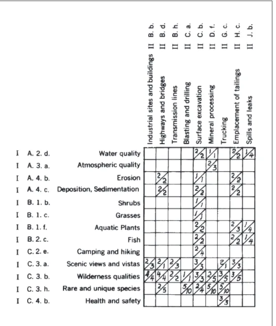
The environmental impact analysis, developed in response to the U.S. National Environmental Policy Act of 1970, can be seen as a forerunner to the TIA. One of the first methods for this was devised and performed by Luna Leopold at the 1972 U.S. geological census. This consisted of a matrix of policy areas and environmental topics. On the horizontal axis, one hundred possible measures of economic policy were listed, and on the vertical axis 88 possible environmental effects. In the resulting 8,800-cell matrix, only the most significant effects, measured in terms of magnitude and importance on a ten-point scale, would be filled in (Leopold et al. 1971, p. 4-5). Since a typical project would involve an average 25-50 interactions, this could be summarized in a separate and smaller matrix (see figure 1). Almost forty years on, adaptations of this method are still being used, most notably for the EU-mandated environmental impact assessment (EIA) and strategic environmental assessment (SEA). Other impact analyses developed in the 1970s include social impact analysis, technological impact analysis and urban impact analysis. The EIA and SEA will be returned to later in the chapter as alternatives to the TIA, but the latter will be discussed in more detail below.
The Urban Impact Analysis (UIA) is a clear predecessor to the TIA, as it sought to assess the impact of non-urban policies (regional, national or even international) on urban areas. Formally, it came about when the U.S. government’s National Urban Policy mandated that federal agencies assess, prior to implementation, the expected changes their policy would have on various relevant urban variables such as finances, housing and accessibility. This was needed because, “the presence of spatial spillovers and interactions between several spatial compartments requires a comprehensive view of the complicated mechanism of a spatial system” (Nijkamp 1981 p. 1). It was seen
as “extremely important” to take into account both intended and unintended effects of policy (p. 28).
For UIAs, a complex multilevel impact assessment was envisioned that considered “spatio-temporal impacts due to dynamic and spatial feed-back relationships between the components of the system” (Nijkamp 1981 p. 1). In the methodology, “economic, spatial, social and environmental variables should be included as relevant components of the system. Preferably, an impact analysis should be based on a formal model” (p. 2). Later in the paper, it was suggested to perform this with an econometric model (p. 9) which allows for the analysis of a multi-dimensional system (p. 11). All in all, it was concluded that UIA “offers an operational tool for assessing direct and indirect, intended and unintended, short-term and long-term consequences of non-urban public policies” (p. 33).
Figure 2. Environmental impact matrix
3.2. The ESPON approach
Arguably the most important work on TIAs under that name has been carried out within the framework of the ESPON programme. Since its beginnings in 2002, it has carried out a number of large-scale impact studies of European policies, with regional effects mapped out for the entire European territory. The policy impact studies up to 2006 – collectively referred to as the ESPON 2006 programme – included the following transnational projects:1
— 2.1.1 Transport Policy Impact — 2.1.2 R&D Policy Impact — 2.1.3 CAP Impact
— 2.1.4 Energy — 2.1.5 Fisheries
— 2.2.1 Structural Funds Impact — 2.2.2 Pre-Accession Aid — 2.2.3 Structural Funds — 2.3.1 ESDP Impact — 2.3.2 Governance — 2.4.1 Environment
In addition to these impact studies, ESPON included TIA development as part of the project specifications for its coordinating cross-thematic projects. Particularly project 3.1 (Integrated tools for European spatial development) and project 3.2 (Scenarios) made significant strides on methodology development, as did project 2.4.2 (Integrated analysis of transnational and national territories), officially labelled a policy impact study, but having more the character of a cross-thematic project. Because of their contribution to TIA methodological development, these projects will be discussed in more detail.
The ESPON 3.1 project set up a general framework of TIAs and evaluated the then available thematic ESPON projects2 as regards their relevance for Territorial Impact
Analysis3 development (ESPON 3.1 2004). In this meta-analysis, the project restricted
itself to making “a compilation of the policy measures in certain regions (input side,
1. The numbers denote project numbers used in the ESPON 2006 programme. Thematic projects all start with a 1, policy impact studies with a 2, and integrative cross-thematic projects with a 3.
2. The seven projects analysed in ESPON 3.1 were: Project 2.1.1: Territorial Impacts of EU Transport and TEN Policies, Project 2.1.2 The Territorial Impact of EU Research and Development Policy, Project 2.1.3 The Territorial Impact of Common Agriculture, Policy (CAP) and Rural Development Policy (RDP), Project 2.1.4 Territorial Trends of Energy Services and Networks and Territorial Impact of EU Energy Policy Funds, Project 2.2.1 Territorial Effects of Structural Funds, Project 2.2.2 Territorial effects of pre-accession aid programmes and Project 2.2.3 Territorial Effects of the Structural Funds in Urban Areas.
3. The project used this term rather than assessment, due to a distinction they wished to make between projects (assessment) and policies (analysis). The reason for this was the wording of the ESDP. As stated earlier, I have chosen to not make this distinction, and use TIA in a broad sense.
e.g. financial interventions), recording what spatial development goals they follow and the structural status/changes in these regions (output side) evaluated against the chosen spatial development goals” (ESPON 3.1 2004, p. 426). In order to do this, a set of “minimum requirements” for a TIA were drawn up, consisting of the following:
1. Scoping
— Reference to causing policy interventions — Hypothesis on cause/effect-relations — Regional scale (min. NUTS 2)
— Reference to past & future interventions 2. Analyzing — Interventions/effects registered — Quantitative/qualitative appraisal — Technique of analysis 3. Assessing — Concepts/goals referred to
— Applied understanding of ‘territorial’ — Territorial reference of outcome
The way in which each project met these requirements was presented in a table (ESPON 3.1 2004, p. 435-436). On the basis of this, the study concluded that, on the one hand, there seems to be a need for TIAs as “the EU policy programmes concerned are still far away from actually taking into account territorial objectives despite they have clear potential territorial impacts” (ibid.). On the other hand, this very fact made it very hard to carry out a TIA due to “a dramatic lack of territorial differentiation of data on policy implementation” (ibid.). In addition to this abstract obstacle was a more fundamental one: there was little clarity regarding how to measure the desirability of impacts, as “the elaboration of spatial development goals in the wake of the ESDP is still going on and has hardly achieved results operational for assessment application so far” (ibid., p. 439). For this reason, the study felt that there was a “need for better definition of spatial development goals which any kind of TIA has to address – focusing on territorial cohesion and polycentric development” (ESPON 3.1 2004, p. 14). Finally, the study found that given the diversity of approaches taken in the ESPON projects, it was probably unfeasible to hope for a single TIA method that could cover the whole range of EU policy issues. I will return to this point later.
The next cross-thematic project, ESPON 3.2 on scenarios, was required to continue methodological work on TIA development (ESPON 3.2 2006; Camagni and Capello 2007). As the project utilized different quantitative models to make projections in areas of demography, transport and economic development, this affected the approach taken towards TIA development in the study. The project included a proposal for a multicriteria model to measure policy impacts called TEQUILA (Territorial Efficiency QUality Identity Layered Assessment). This model would first operate at the generic or European level, producing ‘potential impacts’ based on a specific cause-effect relationship between policy measures and expected results. Afterwards, this information would need to be
translated to the regional level based on various regional characteristics.4 As regards
output, the project team proposed dividing the final impact into three different dimensions of territorial cohesion: territorial efficiency, territorial quality and territorial identity, each of which could be weighted in a flexible manner. These three dimensions are related but not identical to the three pillars of sustainability (economy, society and environment).
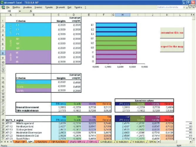
Figure 3. Screenshot of TEQUILA model
Source: ESPON 3.2 Vol. 5, p. 81.
TEQUILA was designed to be simple, operational and relatively user-friendly. In theory, one had just to fill in some values and provide some weights and export this to a map. In reality, and despite its relative transparency for researchers, running TEQUILA required a great deal of work, particularly due to the data requirements. The different steps of the model will be shortly elaborated below as an illustration of how a TIA can be carried out in practice. A more extensive description can be found in the final report (ESPON 3.2 Vol. 5 2006, pp. 68-73) and Camagni (2009).
4. The rationale behind measuring impacts in the TEQUILA model therefore resembles risk assessment where risk = hazard x vulnerability. In this case, territorial impact is the product of a potential impact and a sensitivity indicator.
The first step of TEQUILA is to determine the ‘general impact’ of a EU policy. This is defined by the formula below. This formula simply says that the general impact is the weighted sum of potential impacts for each ‘criterion’: namely the three dimensions of analysis (i.e. efficiency, quality and identity). This formula allows policymakers to, for example, give efficiency twice the weight as identity, or vice versa.
The hard part is determining the potential impacts (PIM). Here a cause/effect relationship between a policy and its effects has to be established and quantified, which is by no means straightforward or easy, and can easily entail an entire scientific study in itself. The impact, for example, of €1 billion CAP or R&D subsidies on territorial efficiency, territorial identity and territorial quality would necessitate an assessment of the workings of the economic, social and environmental system and many – to a certain degree subjective – decisions about whether the impact is positive or negative, and by how much.
The next step of the TEQUILA model is to ‘territorialize’ the results. This is done by taking the potential impact PIM and relating this to the differing (1) sensitivity of regions according to regional specificities and (2) intensity of policy application. It is also possible that a region may not be subjected to a specific policy at all (e.g. Austrian regions for a maritime policy). From these considerations, the following formula was generated for territorial impact per region.
Here too, the difficulty lies not in the formula itself but in how to determine its constituent parts. Like the problems related to determining the potential impact (PIM) sketched out above, we can add difficulties related to choosing which kinds of features of territories would produce different kinds of results, and by how much. For example, how
much should demographic growth or decline change the regional impact of CAP or R&D subsidies (for each criteria)? Again, this requires not insignificant judgments to be made regarding how geographic or other factors influence policy impacts, which again can be considered a study in itself. It is no coincidence that the first run of the TEQUILA model was on the impact of the TENs, as plausible cause/effect relationships were already available from previous and ongoing research.
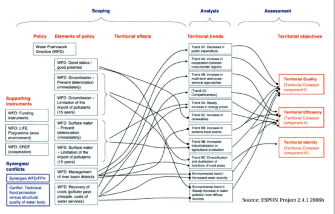
ESPON project 2.4.1 (environmental policy impact) came relatively late in the programme and was therefore able to elaborate a TIA methodology based on the framework of minimum requirements and the TEQUILA model. An innovation in this project was the production of cause-effect chains to assist in determining the extent to which a particular policy affected territorial quality, identity and efficiency (in Greiving et al. 2008). In essence, a ‘storyline’ was produced regarding how policies affect various territorial developments. This exercise was performed for many environmental directives, showing the variety in cause/effect flows. The figure below shows the results of this exercise for the Water Framework Directive. Although this is not the last word on how to deal with the cause/effect problem inherent to the TIA, it did provide a step forward in the methodology development.
Figure 4. WFD causal chain
Source: ESPON 2.4.1, 2006 in Greiving et al, 2008, p. 48.
Other ESPON projects made methodological advances as well. Like the cross-thematic project 3.1, the ESPON project on Integrated Analysis of Transnational and
National Territories mainly reprocessed the data and analyses of previous ESPON results. This was done in order to identify existing spatial patterns and territorial specificities and complementarities (ESPON 2.4.2. 2006). This information proved useful for providing insights into how different (typologies of) territories react to European policies, the second stage of the TEQUILA model (territorialization). Similarly the project on Monitoring Territorial Development (ESPON 4.1.3. 2006) helped to assess the usefulness of various indicators and tools for evaluation purposes.
In the following and current ESPON programme (ESPON 2013), the TEQUILA model was developed further and became increasingly central to, and practically synonymous with, TIA. Shunning all modesty, the architect and mastermind behind the model proclaimed that, “the TEQUILA model makes use of a well established methodology, namely multi-criteria analysis, and applies it in a simplified but careful and creative way to a new scientific mission, namely building a theoretically sound and operational methodology for Territorial Impact Assessment. In this field, it should be considered as a pioneering model, as no other attempts have been carried out insofar [sic]” (Camagni 2009, p. 345).
The first major project to come out of the second programme was TIPTAP (here we see ESPON abandoning its project numbering system in favour of the more common acronym-based system). This project applied TEQUILA to two EU-policies: TEN-T and CAP. This dual case-study approach immediately revealed some of the difficulties of putting the model into practice. For the TENs, a plethora of information was available, not only in terms of detailed quantitative data but also in terms of cause/effect relationships between indicators. The information regarding CAP was more sparse. Expert opinions were needed for drawing up cause/effect chains and the data was more patchy. As recommended in the previous programme, this project involved policymakers in the weighting of the relevance of the criteria (efficiency, identity and quality). It also introduced a system of ‘flagging’ regions which required special attention. A flag could be placed, for example, when certain threshold values are exceeded, or when large trade-offs between criteria are foreseen. As the three criteria (here more accurately referred to as ‘summative dimensions’) territorial efficiency, quality and identity are less readily understood by policymakers, this project also presented results on ‘single dimensions’ such as climate change, economic growth and the like (ESPON TIPTAP 2009).
The TEQUILA model was subsequently applied in the ARTS project (Assessment of Regional and Territorial Sensitivity), intended to carry forward work on developing a TIA methodology by adding the factor of sensitivity. ARTS used the cause/effect chains developed in the ESPON 2.4.1 project to determine the general impacts with some minor modifications. As the name implies, territorialization and notions of regional sensitivity are central to ARTS. To demonstrate the flexibility of its methodology, ARTS performed ‘quick and dirty’ TIAs on nine EU directives, and in-depth TIAs on three others. ARTS also briefly explored whether governance aspects – which empirical studies have found to be decisive in determining sensitivity of countries to EU-directives (and will be discussed in section 4) – could be integrated into the TEQUILA model. Unfortunately, the information requirements proved insurmountable within the limited scope of the project. One of the most important outcomes of the project was a quick-scan TIA which could
be applied in a workshop setting with policymakers. Following the methodology, impact maps could be generated on the spot according to the input of participants regarding cause/effect relationships and opinions about regional sensitivity (ESPON ARTS 2011). Another ESPON project called EATIA takes a different approach. This project is stakeholder-oriented and is being carried out in collaboration with national and regional authorities in Portugal, Slovenia and the United Kingdom. The approach seems less quantitative than previous ESPON work on TIAs as it seeks to address stakeholder concerns. A questionnaire issued to potential users of ESPON TIA research, namely regional governments, revealed that simplicity was essential. For example, an interviewee pointed to the need for “a way of doing TIA that would involve asking just a few very pertinent questions that would open the eyes of people not used to working territorially” (in Hague et al. 2010). In order to further link up to the needs and perceptions of stakeholders, the project is placing governance more central and focusing on drawing conclusions from ESPON TIA results for national and local spatial plans (ESPON EATIA 2010). The project will run up to spring 2012.
3.3. Other EU-level assessments
The debate on TIAs in Europe has run concurrently with the development and implementation of other methods of assessment of policy impact. There are three main areas of note: 1) the various ways in which the most territorialized policy – the structural funds – have been analyzed, 2) the mandatory environmental assessments and 3) the evolving ‘impact assessment’ of the European Commission. These methods will be discussed in turn in this section. In the conclusions, I will reflect on the degree to which TIA might have become redundant in light of these assessments.
Not long after establishing regional policy, particularly the structural funds, criticisms were being made in political and administrative circles about the lack of coherence with other EU policies like CAP, research, and transport. As stated, DG Regio had commissioned reports on the extent to which these policies helped or obstructed the primary goals of regional policy even as far back as the 1980s. Regional policy, in turn, has undergone many external evaluations over the years (see Bachtler and Wren 2006 for an overview), many of which have territorial aspects. An example is the claim that transport infrastructure investments produce economic growth in a particular region. In addition, the periodical cohesion reports produced by DG Regio contain overviews of the impacts of the policy. Although these evaluations are an assessment of a territorialized policy rather than a territorial assessment of sector policy, there is some degree of methodological overlap.
Another tradition, mentioned earlier (§3.1), regards the various environmental impact studies. At the European level, these became mandatory for large-scale spatial projects (e.g. transport infrastructure, water treatment facilities) with the adoption of the EIA Directive in 1985. An EIA must assess direct and indirect effects of a project on the following factors: 1) human beings, fauna and flora, 2) soil, water, air, climate and the landscape, 3) the interaction between the factors mentioned in the first and second indents, and 4) material assets and the cultural heritage (article 3, 85/337/EEC). The
directive also requires that these impacts be taken into account in the final planning decision (art. 8). Although the directive indicates the extent of information that needs to be addressed in an EIA in the annex, no methodology is prescribed. In practice, a wide variety of methods are used and continued to be developed, such as checklists and matrixes (see §3.1), sectoral guidelines, computer model simulations and the like (Morgan 1998, p. 9). In 2001, the Strategic Environmental Assessment (SEA) Directive was adopted to subject plans and programmes as well as projects to an assessment before they are adopted (Stoeglehner et al. 2009). Like the TIA, it is broad in scope and should be carried out at an early stage of the policymaking process. It is composed of a number of phases:
1. Screening: investigation of whether the plan or programme falls under the SEA legislation,
2. Scoping: defining the boundaries of investigation, assessment and assumptions required,
3. Documentation of the state of the environment: effectively a baseline on which to base judgments,
4. Determination of the likely (non-marginal) environmental impacts: usually in terms of Direction of Change rather than firm figures,
5. Informing and consulting the public,
6. Influencing Decision taking based on the assessment and,
7. Monitoring of the effects of plans and programmes after their implementation. Like the EIA, the SEA directive does not elaborate what kind of methodology is required to conduct phase 4.
About the same time the SEA Directive was adopted for member states, the European Commission introduced a new integrated Impact Assessment (IA) procedure to provide a general ex ante evaluation of various policy options before making a formal proposal. The IA comprises “a set of logical steps which structure the preparation of policy proposals at the European level, cutting across and integrating different sectors and dimensions (economic, environmental and social) and replacing all previous single-sector type assessments (environmental, gender, business, health assessments)” (ESPON 3.2, Vol. 5 2006, p. 69). Over the years, the IA procedure has been adapted, with new guidelines appearing in 2005 and 2009. Since 2006, there has been an Impact Assessment Board whose purpose is to evaluate all IA processes and provide recommendations. Since the IA applies to all European Commission proposals, over a hundred IAs are performed annually by the DG making the proposal. Most of these take about a year to eighteen months to carry out, and have varying levels of attention for territorial aspects (Zonneveld and Waterhout 2009). According to the Impact Assessment Guidelines (January 2009) (SEC(2009)92), the general objectives of the IA are:
— “to ensure that Commission initiatives and EU legislation are prepared on the basis of transparent, comprehensive and balanced evidence”,
— to prepare “evidence for political decision makers on the advantages and disadvantages of possible policy options by assessing their potential impacts” through ….. “the likely economic, social and environmental impacts of those options” (p. 4), both “intentional”, i.e. referring to the very objectives of the policies, and “unintended” (p. 31);
— to improve “the quality of policy proposals by providing transparency on the benefits and costs of different policy alternatives” (p. 6).
The breadth and intent of the IA makes it very similar to a TIA – only the distinct focus on territory seems to be missing – calling into question whether or not both methods could be integrated somehow. I will return to this point in the final section.
3.4. Other methods
While not necessarily a TIA per se, Verijken et al. (2010) have devised a quick-scan tool which can be employed to the same end as most TIAs. This method was developed as a relatively simple way to assess future prospects of rural areas in Europe at the regional (Nuts 1) level in response to more sophisticated predictive land-use models such as EU-ruralis, Scenar2020 and FFRAF, all of which require a high level of expertise to calibrate and run. The quick-scan tool uses simple indicators for assessing the three pillars of sustainability (people, planet, profit) independently.
1. The first step of the method is to identify a limited number of indicators for the three pillars. In the case of rural perspectives, a selection was made of the mean economic size of agrarian holdings and mean gross margin per unit of production taken as a proxy for competitiveness (profit), share of agrarian jobs in regional employment (people) and population pressure on agrarian land (people). These indicators were felt by the authors to be crucial for determining the prospects of specific regions in the context of a liberalizing agricultural market.
2. The second step is to quantify the indicators per region. In the case of rural perspectives, indicators were selected that were already quantified and available from Eurostat.
3. The third step is to rank the regions according to their indicator values and future prospects.
4. The final step is to map the regions according to their ranking value into five classes: in the case of rural perspectives, the indicators within pillars were combined/averaged, and some additional adjustments made.
The result of this exercise was three maps of ‘prospects’ for rural regions ranging from most to least favourable (Verijken et al. 2010, pp. 444-446). While easy to read and relatively straightforward, and therefore potentially useful for engaging in a dialogue with stakeholders and policymakers, these maps essentially present a single or a combined
indicator using existing data. Unlike TEQUILA, they are not the outcome of a modelling exercise that produces new data.
A method commonly used for assessing spatial projects (and since 2000 mandatory for large infrastructural projects in the Netherlands), but rarely addressed in the TIA discussion is the cost-benefit analysis (CBA), or the societal cost-benefit analysis (SCBA). While the former seeks to indicate the economic profitability of a particular policy decision (e.g. a new road) and generally sticks to balancing indicators which can be readily quantified and monetized, the latter makes a greater attempt to take a larger range of variables into account, such as social equity and the environment. A similar method used as an ex ante tool for public investment is the Social Return on Investment (SROI), mainly used in the United States. In this sense, a SCBA (or SROI) resembles a TIA in providing a comprehensive assessment as a decision-making support tool, but is less explicitly concerned about the geographical spread of the impacts (ECORYS 2008).
Another assessment method is multi-criteria analysis. This is used in instances where trade-offs are less of a technocratic exercise (such as clear financial gains and losses) and more of a political nature, involving moral and ethical questions (economic development versus social inequality). In this case weights are given to the various criteria in the equation, usually in consultation with policymakers according to their preferences, or in less politicized cases, through expert judgment according to the Delphi method. Results are often expressed in terms of plusses and minuses rather than being quantified and calculated as in a (S)CBA. As stated, the TEQUILA model is based on this method.
3.5. National and local TIAs
Although providing a full review of national TIAs is beyond the scope of this chapter, especially given the other contributions in this volume, an overview can be helpful to contextualize the Dutch case in the following section. Territorial Impact Assessment has a long tradition in Germany (under the legal procedure called Raumordnungsverfahren) and Austria (as a tool applied without legal framework under the term Raumverträglichkeitsprüfung). In addition it can be recognized in similar procedures under different names in Portugal, the Walloon region of Belgium and Finnish Environmental Impact Assessments, which also consider broader social and economic impacts (ESPON 3.1 2004, p. 427). An approach similar to TIA has developed within the spatial planning process for Slovenian highway program.5 In addition, a project was
carried out in Slovenia to assess the territorial impacts of sector policies in 2007, which developed an online decision-making tool. Significantly, it was shown that the Slovenian
5. The amendments to the spatial planning legislation (Amendments to the Act on spatial planning, 1996) introduced the comparative evaluation of alternative proposals as compulsory step in the highway planning procedure. The scope of the evaluation included environmental impacts, technical and functional feasibility, economic aspects and acceptability in the local environment. From highway planning, this practice expanded to all major (mostly infrastructure) projects.
national spatial policy document could be subjected to a TIA by linking its twelve major objectives to indicators used in the TEQUILA model (Golobič and Marot 2008 p. 7).
4. The Dutch experience
The Netherlands has had a mixed and sometimes paradoxical relationship with European integration in general, and European spatial planning and territorial cohesion in particu-lar. Traditionally one of the most Europhilic of member states, the Netherlands surprised the continent by voting against the EU Constitutional Treaty. It was one of the main proponents and drivers of the ESDP process, yet makes national spatial policies virtually devoid of a European dimension, ignores the ESDP, and now actively opposes European spatial planning (Faludi 2010). It was also one of the most fervent proponents of tough environmental legislation, yet was the only member state to vote against tougher air quality standards in 2015 (Dühr 2010, pp. 368-369), partly due to its own difficulties meeting EU environmental standards. These political changes are reflected in part to the impact, real or perceived, of EU policies in the Netherlands.
4.1. Unseen Europe
Although a new spatial policy has already been published in June 2011, the national spatial policy currently in force is articulated in the Spatial Memorandum, presented in 2004 and adopted in 2006 (Ministry of VROM et al. 2004/2006). This policy signalled a clear shift from its predecessors by placing the subsidiary principle at the heart of plan-ning policy, rather than a principle of spatial organization (e.g. concentration, diffusion or polycentricity). This focus made it also more inward-looking, concentrating on which policy areas the national government should remain responsible for and which could be decentralized. Consequently, the European dimension had virtually disappeared from view.6
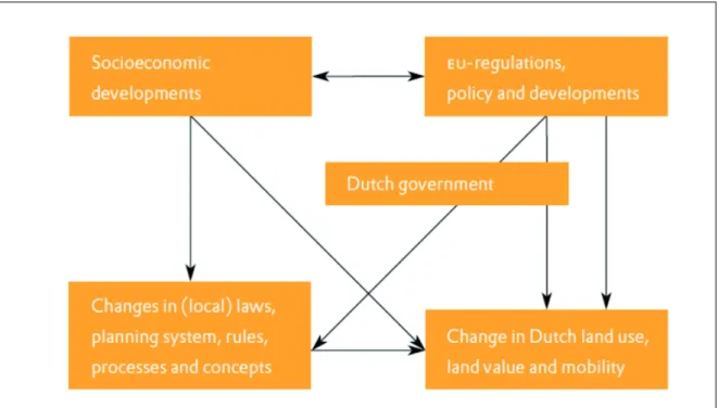
In response, the Netherlands Institute for Spatial Research (now PBL Netherlands Environmental Assessment Agency), an independent think-tank financed by the national government, produced the study Unseen Europe(Van Ravesteyn and Evers 2004). The study asserted that the European dimension, and more specifically, EU policies, affected spatial developments in the Netherlands in significant ways, but since this influence was generally indirect, it remained ‘unseen’. Unseen Europe can be considered a TIA in the broadest sense: rather than focusing on a single policy or project, the study outlined as many examples as possible of territorial impact by the European Union in the Netherlands. The intent was to raise awareness among policymakers, who at the time were unconvinced of the relevance of the European level for spatial policy.
The methodology employed made an analytic distinction between direct and indirect effects on spatial developments. According to the Figure 5 below (Van Ravesteyn and
6. The proposed spatial strategy coincidentally goes even further than its predecessor in decentralising spatial planning, virtually abolishing national spatial planning altogether. Paradoxically, this means that European policy plays an even more determinant role in the national spatial structure.
Evers 2004, p. 13), direct impacts affect spatial developments directly, while indirect impacts are filtered through national government policy and/or the planning system. For direct impacts, information was sought regarding (1) the physical size of affected areas, (2) the size of area-based investment and (3) any reprioritisation of projects. Examples include regulations on public procurement that block or delay projects, business parks constructed thanks to structural funds, and agricultural land uses being determined by CAP policy. As regards indirect impacts on spatial development, the authors felt these could by caused by:
— introducing new spatial concepts (e.g. sustainable development) — creating new administrative relationships (e.g. EU/region, Interreg) — redrawing mental maps (especially in border areas)
— creating new economic activity (e.g. via the internal market or new infrastructure)
— providing information (e.g. publishing rankings of Member States) or — providing sound spatial data.
In practice, the direct/indirect distinction proved methodologically difficult to maintain as all EU policy can be seen as indirect. At the end of the day, it is landowners, municipalities, developers that determine spatial developments, not the European Commission. This, however, generally supported the authors’ main observation that the influence of Europe is hidden from view.
Figure 5. Territorial Impact assessment of EU policies in The Netherlands
The TIA broke down European influence into six themes relevant for spatial development in the Netherlands: regional policy, agriculture, transport, competition, nature and environment and water.7 A separate chapter was written for each theme
containing a policy history at the European level and an estimation of the impact for the Netherlands. This was done on the basis of desk research and interviews and was for this reason speculative in nature. Afterwards, policy trends and possible future impacts were discussed. The thematic chapters closed with an agenda for future research.
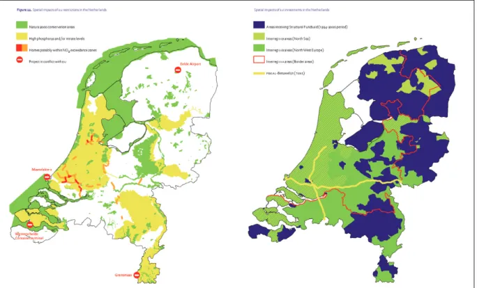
After the thematic chapters, three prominent issues in Dutch spatial planning (urbanization, mainports and rural development) were selected and the interface with EU policies illustrated. In the final chapter, the outcomes of the study were combined into two summarizing maps: one depicting impacts of restrictions on development by policies such as environment and competition (sticks) and a map depicting impacts of policies providing subsidies, area-based or not (carrots). These two maps are presented below.
Figure 6. Spatial impact of policies controling development and of policies providing subsidies
Source: Van Rovesteyn and Evers, 2004.
These two figures proved to be important communicative devices in demonstrating that the Netherlands was not immune from European Union policies: the influence could, in fact, be put on the map. This was also the first time that impacts were presented
7. For other countries, this list would doubtlessly be slightly different. Water is important enough to justify an individual chapter in the Netherlands.
together rather than isolation. The maps also demonstrated that EU influence usually did not necessarily correspond to administrative boundaries or areas identified by national spatial policy. The study also identified a clear rift in administrative culture, with Dutch planning seeking flexibility, integration and compromise and European policy operating with strict performance criteria and legal sanctions. Inevitably these cultures would come to a head. Speaking somewhat hyperbolically, Unseen Europe warned Dutch policymakers that, “although it certainly remains necessarily to conduct spatial policy at the national level (if for no other reason than to coordinate EU policies […]), doing so without regard to the growing influence of Brussels will doom it to failure” (Van Ravesteyn and Evers 2004, p. 139).
4.2. VROM quick scan process
About six months after the publication of Unseen Europe, and following reports that a large number of construction projects were being blocked due to the air quality directive, a member of the upper house of parliament, Margriet Meindertsma, submitted a request to the government to “accrue, bundle knowledge about EU-policy and draw policy consequences regarding our spatial planning, and to make this available to the entire profession” (Eerste Kamer 2005). This request set wheels in motion at all levels of policy formulation in the country and has helped frame government policy ever since.
At the national government level, the Ministry of VROM set up an ‘early warning network’ to spot EU policy topics with a spatial impact, which included representatives from other ministries (BZK, EZ, V&W and LNV), local and provincial authorities with a presence in Brussels and other stakeholders in the field of spatial planning.8 This
network sought to identify new initiatives of the European Commission and estimate the potential effect (opportunities/restrictions) for Dutch spatial planning. This would help the government formulate a standpoint in subsequent negotiations.
4.3. TIAs at the PBL
On 16 November 2007, the Ministry of VROM requested the PBL Netherlands Environmental Assessment Agency to design a TIA methodology for new European Commission policy proposals. The strategy produced was designed to correspond with and support the governmental process that had been set up in the wake of the Meindertsma motion. Rather than being a blueprint for TIAs, the study contained a series of practical guidelines to bear in mind when drawing up a TIA (Tennekes and Hornis 2008). Specifically, the TIA should correspond to the policy phase at the European level:
8. The acronyms used are from the Dutch. Since a government reorganization in 2010, most of these no longer exist.
1. Pre-expert phase: problem definition explored, relatively abstract and esoteric; 2. Expert phase: problem definition elaborated, selection of issues to be discussed in
for example a green paper;
3. Commission phase: policy options elaborated and publicized in, for example, a white paper or communication;
4. Council phase: negotiations between member states in council on options, options further elaborated and narrowed;
5. Comitology phase: negotiations between European parliament and council towards final decision;
6. Implementation phase: incorporation into national legislation/policy (ibid., p. 21). At earlier stages of the policy process, the TIA should be rather broad in order to capture the entire range of possible directions EU-policy can take. At later stages, as the range of possibilities has narrowed down, more detailed research can be carried out on the most likely, or already established, policy options. Even after the policymaking phase at the EU level has been completed, a TIA can explore the potential impacts of choices made during implementation at the national and regional level (Tennekes and Hornis 2008).
PBL-TIA strategy checklist
The TIA strategy is a set of guidelines specifying what kind of assessment would be appropriate for any given proposal from the European Commission. This is dependent on a number of factors, such as the specific knowledge requirements of the Dutch government, the degree to which effects are deemed to be critical and the position of the proposal in the European policy-making process. The following steps indicate issues and questions that need to be taken into account when carrying out a TIA at the PBL.
Step 1: survey the situation
Determine the policy phase on the basis of relevant documentation and procedures. Determine policy significance in consultation with the Ministry of VROM. Determine knowledge requirements. Determine possible impacts, their extent (e.g. magnitude, irreversibility, urgency), their relevance for the spatial structure and their relevance for spatial policy and objectives.
Step 2: analyze problem and context
In the second step, the problem to be solved by the proposed EU policy needs to be addressed. Here various cause/effect chains are mapped out. How did this problem arise and what are the driving forces behind it? What is expected for the future? Is the proposed policy the only solution or are there others?
Step 3: identify alternative policy options
In many cases policy options have already been proposed or being debated. This may not be the case in very early phases of the policymaking process (expert phase) however. In such a situation, a scenario approach can be used to generate possible policy options.
Step 4: estimate impact for the Netherlands
For this step, a number of questions are posed for each possible interpretation. Which actors will be affected by the policy and for what activities? To which extent will the legal and administrative framework change? Which geographical areas are affected and to which extent? To which extent do the actors experience this as an advantage or disadvantage?
Source: Evers et al, 2009, adapted by author.
Most of the PBL strategy concerns how to set up the TIA rather than how to carry it out. The latter is at the discretion of the researcher. Nevertheless, the strategy provides examples of different kinds of evaluations that can be made. One is to produce an effect matrix along the lines of an EIA. Such a table should include the (1) duration and frequency, (2) reversibility, (3) restorability, (4) probability and (5) scale and range (ibid., p. 30). An effect table in this regard can be sufficient for some kinds of proposals, but others will require an assessment of existing or potential policy options. The methods suggested in this regard, (social) cost-benefit analysis and multi-criteria analysis have already been discussed. The results of these analyses can be presented in terms of measured effects, or in relation to current spatial policy (ibid., p. 34). Finally, the PBL strategy emphasizes that attention needs to be paid to the governance aspect in addition to measuring physical or economic effects using (S)CBAs and MCAs. The Dutch Ministry of Transport, for example, already has a legal impact assessment methodology to signal legal risks at an early stage (Ministry V&W 2006). One can also perform an ‘actor-centred cost-benefit analysis’ to estimate the way in which the EU proposal will affect certain parties involved in spatial development in order to help predict how they will act in practice. This knowledge can be used for coalition building.
So far, the TIA strategy has been carried out twice at the Netherlands Environmental Assessment Agency at the request of the Ministry of VROM. The first regarded territorial cohesion policy, which was in the expert phase and the second was on the energy-climate package, which had already arrived at the implementation phase. Given the two very different points of the policy process, the studies are very different in character in terms of methodology and conclusions.
The TIA on territorial cohesion was carried out just prior to the publication of the Green Paper on Territorial Cohesion (CEC 2008). When the TIA began there was no agreement on a problem definition or even a definition of the term itself. On the other hand, territorial cohesion had already been included in the Lisbon Treaty, which was
expected to be ratified in the near future, as an objective of the European Union. Given this curious situation, various interests attempted to imbue the term with meaning towards a particular problem definition, presumably with the intent to set the agenda in their favour. In essence, various political discourses existed at the European level, each of which identified a different ‘problem’ to fit the ‘solution’ of territorial cohesion (Evers 2009). Based on a discourse analysis of European-level documents, reports of meetings at European institutions and similar exercises (Waterhout 2008; Doucet 2006; Evers 2011), five different interpretations of territorial cohesion were identified. For each interpretation, the problem definition was explored and potential policy options distinguished. Rather than aiming to be ‘realistic’, the policy options were designed with the intent to show the outer extremes of policymaking; this would increase the chances of actual measures falling within these parameters (so as not to be surprised by extent of future proposals) and increase the potential territorial impact.
In the end, the study found that policy options in the interpretations ‘economic competitiveness’, ‘spatial planning’ and ‘policy coordination’ had potentially positive impacts for the Netherlands. The last of these, incidentally, included increased use of TIAs. The study also found that even in seemingly favourable options, one would have to remain vigilant about which indicators and standards would be used and recommended remaining active in the territorial cohesion process (Evers et al. 2009).
Interpretation Problem definition Policy options Socio-economic
convergence
Disparities within Europe are territorially defined
1. Regional convergence 2. Convergence within nations 3. Territorial solidarity
Economic competitiveness Competitive position of Europe depends on using territorial capital
1. Growth areas targeted 2. Facilitate agglomeration Rural perspectives Specific rural problems need
territorial approach
1. Rural rescue plan 2. Regional differentiation Spatial planning Unbalanced spatial development
and sprawl
1. Planning for Europe 2. Planning in Europe Policy coordination Lack of coordination of EU policy 1. More coherent EU policies
2. Flexibility via territoriality Source: Evers et al. (2009), p. 12.
The next TIA concerned the national climate and energy policy package being implemented to meet European targets (Van Hoorn et al. 2010). Since this TIA was far beyond the point of a European Commission proposal, its methodology was quite different. There was no need for an exploration of possible policy options, because these had already been selected. Since the Dutch government has also committed itself to making an extra effort beyond the European minimum levels, the study took these
figures as its starting point: reduction of greenhouse gasses up to 30% under 1990 levels, increase in share of renewables to 20% by 2020 and 2% annual increase in energy savings over the 2011-2020 period.
Given these explicit objectives, the study then explored the kinds of policy options that could be implemented to meet the targets. It began by presenting a list of cost-effective options (based on earlier research) that could be introduced at the national level. Many of these had no spatial component, and it was estimated that over half of the target values could be reached using non-spatial measures (Van Hoorn et al. 2010, p. 28). The TIA then grouped the policy options that did have a spatial component into the following categories: urban environment, wind energy, car transport, biomass and carbon capture and storage, which were then analyzed in separate chapters. In each chapter, (1) the necessary policy measures were listed, along with (2) the concerns and interests of the actors involved, (3) the likely spatial9 impacts of these policy measures,
(4) the suitability of the spatial planning system to deal with these and (5) potential contributions of the planning system to meeting the national targets. Obviously, the last two points go beyond the requirements of a TIA, but in this context were necessary to help policymakers use the planning system, rather than being obstructed by it.
In the end, the TIA found that the national targets set in response to the climate and energy package had important implications for spatial development in the Netherlands. New energy technologies were expected to change the appearance of buildings, urban development and design and rural landscapes. Sometimes the planning system was experienced as a barrier (e.g. lengthy procedures), but in other cases it expedited the process. The study found that it was important that national, regional and municipal spatial visions interface with the climate and energy objectives (Van Hoorn et al. 2010).
4.4. Other Dutch studies
While not TIAs in name, two noteworthy reports were produced in the past few years in the Netherlands that shed light on how European policy affects territories. Also partly in response to the Meinerdsma motion, the Dutch Council for Housing, Spatial Planning and the Environment (VROM-Council) produced a report which exposed the governance aspect in more detail. The other report was commissioned by the Ministry of VROM to investigate the phenomenon of overlapping sectoral policies in area-based development (Zonneveld et al. 2008).10 Each of these will be shortly elaborated and their conclusions
discussed in light of further TIA development.
The VROM-Council report made an important distinction as regards regional sensitivity to European policy. Regions, it claimed, can be more susceptible to the effects
9. This study focused explicitly on the spatial rather than territorial impacts. This was necessary because much of the impacts were either at a very low spatial scale or concerned effects which transcended administrative boundaries.
10. For an English-language paper based in part on this research, see Zonneveld and Waterhout . For an English-language paper based in part on this research, see Zonneveld and Waterhout (2008).