ii
Verkenningen, deel 7
Eerder verschenen in deze reeks:
1. De toekomst van het wiskunde-onderzoek in Nederland 2. Bio-exact. Mondiale trends en nationale positie
in biochemie en biofysica
3. De toekomst van de theologie in Nederland
4. Tussen Aarde en Leven. Strategische verkenning van de biogeologie in Nederland
5. De appel van Newton. Nieuwe mogelijkheden voor natuurkundig onderzoek van levende materie
6. 'Gij letterdames en gij letterheren'. Nieuwe mogelijkheden voor taalkundig en letterkundig onderzoek in Nederland
Amsterdam, 2005
Royal Netherlands Academy of Arts and Sciences Dutch Foresight Committee on Hydrological Science
Turning the Water Wheel Inside Out
Foresight Study on Hydrological
iv
Royal Netherlands Academy of Arts and Sciences P.O. Box 19121, 1000 GC Amsterdam, The Netherlands
T + 31 20 551 07 00 F + 31 620 49 41 E knaw@bureau.knaw.nl
www.knaw.nl isbn 90-6984-438-9
The paper in this publication meets the requirements of ∞ iso-norm 9706 (1994) for permanence.
© 2005 Royal Netherlands Academy of Arts and Sciences
No part of this publication may be reproduced, stored in a retrieval system or transmitted in any form or by any means, electronic, mechanical, photocopying, recording or otherwise, without the prior written permission of the publisher.
De reeks verkenningen van de knaw wordt in het Nederlands uitgegeven, deze verkenning is echter in het Engels opgesteld. Daarom zijn het voorwoord, de conclusies en aanbevelingen in het Nederlands vertaald en opgenomen.
The Academy’s Foresight Study series is published in Dutch; this particular study, however, was written in English. A Dutch translation of the foreword and the conclusions and recommendations can be found in this publication.
vi
Voorwoord
Inzicht in de ontwikkeling van de wetenschapsbeoefening is een voorwaarde voor een beleid dat recht doet aan de wetenschap. Het ligt op de weg van de Koninklijke Nederlandse Akademie van Wetenschappen om dit inzicht te ver-schaffen. De Akademie heeft dan ook een centrale taak bij het totstandkomen van verkenningen vanuit wetenschappelijk perspectief.
Onder een wetenschapsverkenning verstaat de Akademie het verwerven van inzicht in de wetenschappelijke ontwikkelingen op langere termijn op een be-paald gebied, het in dat licht bepalen van de internationale positie van het Neder-lands onderzoek en het doen van aanbevelingen voor het te voeren beleid.
Het hydrologisch onderzoek bestudeert de hydrologische cyclus, dat wil zeg-gen het voorkomen, de beweging en de samenstelling van water onder en op het aardoppervlak en poogt inzicht te krijgen in de interactie van die cyclus met de geosfeer, de atmosfeer en de biosfeer.
Hydrologie is bij uitstek een interdisciplinaire wetenschap. Hydrologisch onderzoek vereist vaak expertise op het gebied van andere disciplines, zoals wiskunde, vloeistofmechanica, bodemfysica, bodemmechanica, biogeologie, biogeochemie, chemie, ecologie, meteorologie, en reservoirtechniek. De inter- actie van hydrologie met deze disciplines – en daar komen er in de toekomst
Foreword
Any policy intended to support and promote science must be based on a thor-ough understanding of current and future advances in research. It is one of the tasks of the Royal Netherlands Academy of Arts and Sciences to investigate such advances and to make it possible for research foresight studies to be carried out.
The Academy believes that a research foresight study involves investigating long-term developments in a particular field, assessing the strategic position of Dutch research in that context, and making the necessary policy recommenda-tions.
Research in the field of hydrology focuses on the hydrological cycle, in other words the occurrence, transport and composition of water below and on the earth’s surface. It attempts to understand how that cycle interacts with the geo-sphere, the atmosphere and the biosphere.
Hydrology is an interdisciplinary science. Hydrological research often requires expertise in other disciplines, for example mathematics, fluid mechanics, soil physics, soil mechanics, biogeology, biogeochemistry, chemistry, ecology, mete-orology, and reservoir engineering. The interaction between hydrology and these disciplines – and no doubt many others in the future – has led to many new and promising opportunities for interdisciplinary research.
viii Voorwoord
ongetwijfeld nieuwe interacties bij – zorgt voor vele nieuwe uitdagende mogelijk-heden voor interdisciplinair onderzoek.
Dit verkenningsrapport bevat aanbevelingen voor universiteiten, niet-universi-taire onderzoekinstituten, financiers van wetenschappelijk onderzoek en beleids-makers. De knaw hoopt hiermee een bijdrage te leveren aan de verdere groei en grotere zichtbaarheid van dit internationaal georiënteerde veld.
Wegens de internationale oriëntatie van hydrologisch onderzoek wordt het rapport van de Verkennings Commissie Hydrologie in het Engels gepubliceerd, de conclusies en aanbevelingen zijn in het Nederlands opgenomen.
De Akademie hoopt en verwacht dat dit Hydrologie-verkenningsrapport en de daarin geformuleerde aanbevelingen als belangrijk richtsnoer zullen dienen bij het te voeren langetermijnbeleid voor de hydrologie.
Prof. dr. W.J.M. Levelt President knaw
The present foresight study makes recommendations for universities, non-uni-versity research groups, research financing bodies and policy-makers. The Acad-emy hopes in this way to draw attention to this international field of research and to contribute to its growth.
Because hydrological research is international in nature, the report of the Foresight Committee on Hydrological Science has been published in English. A Dutch version of the conclusions and recommendations is also included.
The Academy hopes – and indeed expects – that this Foresight Study on Hy-drological Science and the recommendations it puts forward will provide impor-tant guidelines for a long-term policy on hydrology.
Prof. W.J.M. Levelt, President
Contents
Summary xv1. Introduction 1 1.1 Background 1
1.2 Terms of reference Foresight Committee 3 1.3 Committee’s activities 4
2. Hydrology, the science 7 2.1 Definition 7
2.2 Hydrology: an interdisciplinary science 9 2.3 Relevance of hydrology 11
3. Challenges ahead in international hydrological research 17 3.1 Introduction 17
3.2 Interaction between the hydrological cycle and terrestrial ecosystems 18
3.3 Human impacts on the water cycle and the geo-environment 20 3.4 Interaction between the hydrological cycle and landscape processes 23 3.5 Climate change and variability 25
3.6 Methodological issues in hydrological research 28 3.6.1 Heterogeneity and scale 28
3.6.2 Observation and measurement techniques 29 3.6.3 Fundamental theories 30
3.6.4 Quantification of uncertainties 30
4. Priority themes for Dutch hydrological research 35 4.1 A focused agenda for Dutch hydrological science 35 4.2 Hydrology and climate 36
4.2.1 Detection 37 4.2.2 Impacts 38 4.2.3 Feedbacks 40
4.3 Hydrology and Geo-ecosystems 41
4.3.1 Patterns and complexity in landscapes 42 4.3.2 Interaction between land use, surface hydrology,
xii Contents
4.4 Hydrology and Geo-environment 46
4.4.1 Interaction of surface water and groundwater 48 4.4.2 Improved theories for multiphase flow 50 4.4.3 Density-dependent flow and transport 50 4.4.4 Multi-scale reactive transport 52
5. Education Programmes in Hydrology 55 5.1 Introduction 55 5.2 Specialisations 56 5.3 Collaboration 58 5.4 Career prospects 58 6. Research Infrastructure 63 6.1 Introduction 63
6.2 swot analysis of Dutch hydrological research and education 64 6.3 Towards an infrastructure for directing and prioritising hydrological
research and education 66 6.3.1 Introduction 66
6.3.2 Boussinesq Centre for Hydrology 67 6.3.3 Major activities 68
6.3.4 Relation to existing organisations and programmes 71 6.3.5 Implementation 72
Conclusies en aanbevelingen 74 Conclusies 74
Aanbevelingen 82
Conclusions and recommendations 75 Conclusions 75
Recommendations 81
Literature 88
Annexes
A. Members of the Dutch Foresight Committee on hydrological science 91 B. List of participants at four Expert Meetings and their disciplines, March
C. List of other experts consulted during the Preliminary Foresight and the Foresight Study 101
D. Hydrological science disciplines 103
E. Current research programmes of Dutch hydrology groups 115
F. University research groups with relations to hydrology: possible research partners for hydrological research 127
G. Hydrology MSc programmes: list of MSc courses and compulsory BSc courses 129
H. Institutional and Scientific Developments in Hydrological Research in The Netherlands 132
List of acronyms 137
Papers
Existing and emerging remote sensing techniques for hydrological application, Peter Troch 14
Upscaling, why and what, Toon Leijnse 26
The contribution of Hydrology to Ecology, Jan van Groenendael 32 Interactions of the Atmospheric Boundary Layer with the Land Surface,
Bert Holtslag 53
Summary
In this report, the Hydrology Foresight Committee presents her findings of the study of the current status and potentials of hydrologic research in The Nether-lands, and prospects for future developments. Terms of Reference of the Committee and details of her activities are described in Chapter 1.
A detailed description of hydrological science, its strong interdisciplinary character, and its social relevance are given in Chapter 2. Various disciplines of hydrology are described in Annex D. The Committee elucidates that hydrology is a vital component of the earth system science. Hydrology concerns the occur-rence, movement and composition of water below and on the earth’s surface. It is an interdisciplinary science with strong links to biology, geology, oceanography, atmospheric and solid earth sciences.
The Committee explains the social relevance of hydrological research as it plays an important role in helping to solve global problems, such as water scarcity and lack of food security. Hydrology provides the knowledge that is needed to predict the occurrence of natural and human-induced hazards such as floods, droughts, and water pollution.
The Committee identifies a number of major challenges in international hy-drological research, as detailed in Chapter 3. These are classified under four key
xvi
research areas and four methodological issues. The key research areas are listed as:
– Interaction between the hydrological cycle and terrestrial ecosystem. – Human impacts on the water cycle and the geo-environment. – Interaction between the hydrological cycle and landscape processes. – Climate change and variability.
Progress in these research areas can be made only if we find solutions to the fol-lowing methodological issues:
– Heterogeneity and scale.
– Observation and measurement techniques. – Fundamental theories.
– Quantification of uncertainties.
The Committee recognizes that Dutch hydrologists play a prominent role at the international level, and that there are tremendous opportunities for them to become key players in a number of important breakthroughs in global hydrology. To make this possible, it is necessary to formulate a focussed research agenda and to establish an effective organizational structure for coordinating hydrological scientific research.
The Committee has identified three priority research themes that should form the basis for a focussed research agenda. These choices are made based on the prospects for keeping Dutch hydrology at the forefront internationally, stimulat-ing intensive interdisciplinary research, and enhancstimulat-ing the fundstimulat-ing potentials. The three priority themes for Dutch hydrology, explained in detail in Chapter 4, are:
1. Hydrology and climate.
2. Hydrology and geo-ecosystems. 3. Hydrology and geo-environment.
The Committee has prepared a thorough overview of hydrology education pro-grammes in the Netherlands, as detailed in Chapter 5, where possibilities for improving these programmes are also discussed.
The Committee has performed a swot analysis of Dutch hydrologic research and education in Section 6.2. This swot analysis has aided in outlining and identifying measures that are needed to advance hydrological science in The Netherlands.
The Committee recommends establishing a virtual research centre dedicated to focussing and strengthening hydrological research in The Netherlands, based on the priority themes mentioned above, and within an interdisciplinary research framework. Details of major activities and the various phases of implementation of such a hydrology research centre are described in Section 6.3.
1. Introduction
1.1 Background The Academy
The Royal Netherlands Academy of Arts and Sciences (knaw) is the official advisory body to the government on scientific matters. Disciplinary councils of the Academy prepare and implement reports both on request and on their own initiative. The ‘core business’ of the advisory councils is to organise research foresight studies. The main purpose of these foresight studies is to give direction to scientific developments and to offer a basis for the setting and selection of priorities.
Earth and Climate Council (RAK)
The Earth and Climate Council of the Royal Netherlands Academy of Arts and Sciences was established in 2000 as one of the Academy’s advisory councils. These councils consist of both Academy members and non-members, including university professors and researchers from public research institutes and private industrial companies. The Earth and Climate Council aims to develop a coherent vision of the Earth Sciences in The Netherlands. The Council gives solicited and unsolicited advice to the Academy Board and, through the Board, to the government, universities, research institutes, funding agencies and
2
national and international organisations. The scope of the Council includes sciences involved in describing and understanding the earth system and covers the study of physical, chemical, geological and biological processes which regulate the earth system and their interaction in the past, the present and the future. In 2001, the Council decided, after close consultation with the Dutch Hydrological Platform (see next paragraph), to seek the Academy Board’s consent to conduct a preliminary foresight study to investigate the impetus and necessity for an hydrology foresight study. The rak suggested to the Academy Board that it should install a committee consisting of hydrology professors who had recently been appointed to Dutch universities.
The Dutch Hydrology Platform
Dutch hydrologists have always had a prominent role in the international hydrological community and they have contributed significantly to hydrological science. In recent decades, the severity of many water-related global and regional problems has increased dramatically. Hydrologists worldwide have taken up a central role in searching for solutions to world water problems. In order to unify the efforts of Dutch hydrologists in meeting the challenges ahead and in order to improve the visibility of hydrology at the national level as a separate scientific discipline within the earth sciences, the ‘Netherlands Hydrology Platform’ (Nederlands Hydrologisch Platform, nhp) was established in 2001. The objectives of nhp are: to show the strength and possibilities of hydrology as an independent science; to survey all hydrological research activities; to improve communication between PhD students and researchers; and to create a database with information on hydrological research in The Netherlands. Members of nhp are the hydrology professors at Dutch universities and key scientists at institutes that are involved in hydrological research.
Preliminary Foresight Committee
A Preliminary Foresight Committee has carried out an extensive preliminary foresight study and produced a report entitled ‘Hydrology: a Vital Component of Earth System Science’ in December 2003.
The main tasks of the preliminary committee were:
– To draw up an overview of the field of hydrology, the place of fundamental hydrological science, the direction in which hydrological science is developing and the scientific challenges of hydrology.
– To compose a list of related disciplines (such as biology, geology, meteorology, oceanography and mathematics) that must be taken into account.
– To conduct a survey of hydrological research in The Netherlands: what type of research, who is involved, and where is it executed.
– To make recommendations for a possible in-depth foresight study and how such a foresight should be executed.
The Preliminary Foresight Committee proposed four priority themes for hydrological research in The Netherlands for the next ten years. The preliminary committee strongly recommended that an in-depth foresight study of hydro-logical science should be carried out, in order to address a number of important questions, which are described below. The Committee suggested enriching the current preliminary committee with three members from the related disciplines of mathematics, biology, and meteorology.
1.2 Terms of Reference Foresight Committee
Following the publication of the preliminary foresight study report, the Royal Netherlands Academy of Arts and Sciences decided to commission a Foresight Committee on Hydrological Science (Verkennings Commissie Hydrologie, vch) to conduct a foresight study describing in detail the relationship between hydrology and other disciplines, for example ecology, meteorology and mathematics. The foresight study on hydrology must produce specific recommendations for govern-ment and other sponsors, universities, and research organisations.
The Royal Netherlands Academy of Arts and Sciences wishes to use the fore-sight study on hydrology to identify the most important advances in interna-tional research in this field and to map out a strategic position for Dutch research within that context.
The vch should:
– confirm the priority research themes identified in the preliminary report and explore these themes, and the relationships between them, in detail;
– consider how the priority research themes can be incorporated into interdisci-plinary research programmes;
– analyse the strengths and weaknesses of hydrological research in The Nether-lands, as well as study how the strengths can be enhanced and the weaknesses eliminated;
– investigate structural changes that will benefit the way in which hydrological research is organised and financed;
– consider the Masters degree programmes in hydrology and related disciplines. The vch should specifically consider how best to design programmes in hy-drology and related disciplines such that they train a sufficient number of researchers in hydrology in the future.
4
1.3 Committee’s activities
The Committee consisted of eight members: the five members of the Preliminary Foresight Committee plus an ecologist, a mathematician, and a meteorologist. This Committee was able to continue building on the work done by the Prelimi-nary Foresight Committee.
Chapters 1, 2 and 3 of this report are based mainly on the preliminary fore-sight study report. After describing hydrological science as an earth science and the general international challenges for hydrological science, the Preliminary Foresight Committee goes on to identify five methodological issues and four thematic key research areas. The thematic key areas concern the fundamental understanding of the hydrological cycle in relation to:
– Terrestrial ecosystems. – Human impacts.
– Landscape processes and, – Climate change and variability.
The key research areas and five methodological issues identified in hydrology are described in Chapter 3.
Based on these key research areas, the Preliminary Foresight Committee selected four priority themes for hydrological research in The Netherlands to investigate in greater detail:
– Interaction of the hydrological cycle with the terrestrial biosphere (‘ecohydrology’).
– Hydrology of large river systems: human impact and climate change. – Soil moisture dynamics at the landscape scale.
– The fate of contaminants in the subsurface.
These ‘Dutch’ priority themes, which were described in detail in the report of the Preliminary Foresight Committee, were discussed with a group of active research-ers from hydrological and related disciplines during four Expert Meetings in March 2004 (see Annex B for the list of participants). Based on results of these expert meetings and internal discussions of the Committee, the above-mentioned priority themes were revised and reformulated into three priority themes with a strong internal coherence. The priority themes for The Netherlands are described in detail in Chapter 4.
In addition to expert meetings, input was sought from the hydrological com-munity through visits to the coordinators of Masters Programmes in Hydrology
in The Netherlands and interviews with a number of prominent scientists who were not visited during the Preliminary Study. The people visited during both the Preliminary Study and the Foresight Study are listed in Annex C.
2. Hydrology, the science
2.1 Definition
Hydrology is a scientific discipline within the earth sciences. Its main focus is the terrestrial part of the hydrological cycle (see Figure 1). Hydrology concerns the occurrence, movement and composition of water below and on the earth’s sur-face. Hydrological science has strong links, on a wide range of spatial and tem-poral scales, with oceanic, atmospheric, and solid earth sciences as well as with biological sciences.
More specifically, the aims and scope of hydrology are:
– To understand the mechanisms and underlying processes of the hydrological cycle and its interactions with the lithosphere, atmosphere, and biosphere. – To enhance our knowledge of interactions between hydrosphere and
atmos-phere, hydrosphere and lithosatmos-phere, and hydrosphere and biosatmos-phere, thereby increasing our understanding of the role that water plays in the Earth System. – To quantify human impact on past, present, and future conditions of
hydro-logical systems.
– To develop strategies for sustainable use and protection of water resources, hydrological systems, and associated environmental conditions.
8
Within hydrology, fundamental and applied research emphasises the devel-opment of explanatory and predictive models of water availability, flow, solute transport, and fluxes of energy, nutrients, and carbon, and their interactions. Hy-drological research is based on sound physical and chemical theories and takes account of geological and biological environmental controls.
One should not confuse hydrology with ‘water science’. Water science is a much broader field that deals with all aspects of water and includes disciplines such as aquatic ecology, social economy, etc. It has received considerable atten-tion in recent years due to possible changes in water availability and quality that may occur as a result of climatic and global change. Of course, in these issues, hydrology plays a role in understanding specific changes in stocks and fluxes that may occur.
Hydrology and water management are, despite their strong traditional links, rather distinct disciplines. Water management is primarily concerned with policies and methodologies that are related to optimising water quantity and quality for agriculture, fisheries, transport over inland waters, urban settlement, industrial activities, infrastructure, and the protection of the population against floods and droughts. Hydrology is concerned with the dynamics of water in the hydrological cycle, both with regards to stocks and fluxes. As such it provides the background scientific knowledge and the predictive/descriptive models that are needed for the development of methodologies and policies of water management.
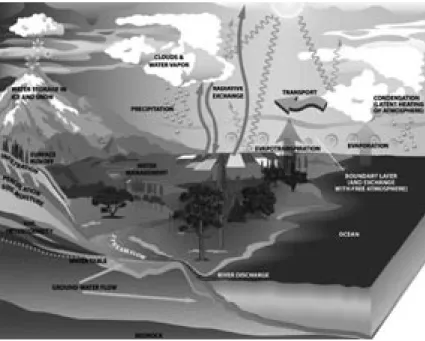
Figure 1. Elements of the Hydrological Cycle.
This foresight study deals with hydrology as a distinct discipline in earth system sci-ence and for this reason, water management issues are not explicitly addressed, except in the discussion of global change impacts on hydrological systems.
2.2 Hydrology: an interdisciplinary science
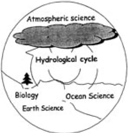
Water plays an important role in almost all human activities on the earth. As a result, hydrology has close links with many branches of science. But, the strongest links are, through the hydrological cycle, with other Earth System sciences such as atmospheric sciences, biology, geology, oceanography and solid earth sciences. A schematic presentation of the controlling role of the hydrological cycle (and thus hydrology) in other systems on the earth is given in Figure 2.
Figure 2. The central role of hydrology as an earth system science (redrawn after Eagleson et al., 1991).
Hydrology has important links to solid earth science through geomorphology, geology and geophysics. Water, its movement and its properties play a central role in shaping the surface of the land; geomorphology is the science that deals with this interaction. While shaping the land surface, water’s biogeochemical properties change and nutrients and other solutes dissolve in it. The flow of small streams to rivers redistributes the dissolved elements and this has major implica-tions for the nutrient availability in coastal areas and that, in turn, determines the growth of phytoplankton. On geological time scales, groundwater interacts with sediments during diagenesis and may enhance secondary permeability while seeping through cracks. Geophysical methods are very important in the study and characterisation of groundwater systems (both saturated and unsatu-rated).
10
Links with oceanic science exist particularly in the case of shallow coastal zones, where input into the ocean is important and interactions between the salty and fresh groundwater can occur. The input of fresh water into the oceans, particularly in the Arctic, affects the thermo-haline circulation.
The link between hydrology and biology is through vegetation at the land surface, biogeochemistry in the subsurface, and aquatic ecology. Vegetation plays a pivotal role in that, on one hand, it regulates the flow of water through evapo-ration, and on the other hand, it is dependent on adequate water supply. Water flow, often influenced by vegetation itself, also causes spatial redistribution of nutrients and thus influences growth conditions and through this the vegetation patterns we observe. Vegetation also plays a key role in helping to shape the land by changing infiltration characteristics through root growth, and by controlling the soil moisture supply, which in turn, affects runoff patterns and groundwater recharge.
Links with the atmospheric sciences are obvious: the study of the hydrological science requires a thorough understanding of rainfall and evaporation processes over land and ocean, while successful prediction by atmospheric circulation models requires a knowledge of surface hydrological processes.
One of the strongest and broadest cooperation links has been with mathema-ticians. Many mathematicians have taken a wide-ranging interest in, and have contributed significantly to, the study of equations that govern hydrological processes. The cooperation with mathematicians over the years has involved the analysis of (often leading to analytical solutions for) governing equations, nu-merical solution of these equations (resulting in simulation models), and devel-opment of various methods for stochastic analysis, inverse modelling, parameter estimation, and data assimilation.
In surface hydrology, there are close links to fluid mechanics, which is one of the basic scientific disciplines of hydrology, and to river hydraulics, in relation to the study of flood wave propagation, sedimentation and erosion, and river mor-phology.
Subsurface hydrology shares many areas of common interest with reservoir engineering, soil physics, soil mechanics, geotechnical engineering, chemical engineering, river and hydraulic engineering, and any science or industry where porous media flow and transport occurs (as in plant physiology, medical engineer-ing, paper and textile industry, etc.). In relation to the unsaturated zone hydrol-ogy, the movement of moisture and solutes is an area of common interest to soil physicists, plant physiologists, agronomists, and hydrologists. In particular, there has been much collaboration between soil physicists and hydrologists. In this
same area, researchers in soil mechanics have been working with hydrologists to study the effect of soil saturation and moisture movement on soil strength and stability. There are also links with plant physiology (uptake of moisture and sol-utes by plants and flow of sap through plant tissues), medical engineering (flow of fluids and gasses in human tissues or implants), and with paper and textile industry (moisture transport), and food sciences (drying processes).
A detailed description of various disciplines of hydrological science is given in Annex D, where also a comparison between hydrological science and engineer-ing hydrology has been made.
2.3 Relevance of hydrology
There are four basic requirements to support the sustainability of a human popu-lation at any scale, be it a tribe, a village, a city, an entire nation, or a whole con-tinent. These are: sustainable supply of fresh water, food, energy, and the avail-ability of habitable space. Of these, loss of fresh water is the most life-threatening factor. Many civilisations (for instance the Mayas) are believed to have disap-peared due to the decline or disappearance of fresh water resources.
Fresh water is perhaps the single most important resource on earth. Water on land serves as a source of drinking water and food production and is vital to almost all ecosystems. The presence of water vapour in the atmosphere causes the earth’s surface temperature to be suitable for living organisms. Clearly, water makes life possible. However, lack of water (droughts) or too much water (floods) can also pose threats to mankind.
Hydrology is concerned with the terrestrial part of the water cycle. This is by far the most relevant part, as it is attainable for human consumption and use, while it is also the part that is linked to natural hazards. By studying the terrestrial water cycle, hydrology thus plays an important part in helping to solve global issues such as water scarcity and lack of food security. Hydrology also provides the knowledge to predict the occurrence of natural and human-induced hazards such as floods, droughts, erosion, landslides, mud flows and water pollution. Also, measures to mitigate such hazards can only be based on sound hydrological knowledge.
The fate of many precious ecosystems on earth, such as rain forests and wet-lands, depends heavily on the abundance of water and its composition. Hydrol-ogy helps us understand how water quantity and quality relate to climate change and human impact. It is also instrumental to understanding the dependence of ecosystem functioning and biodiversity on water quantity and quality.
12
Recent insights into the climate system show that terrestrial water provides an important control on climate variability and change, both directly, through land-atmosphere exchange of water and energy, and indirectly, through fresh water influx to the oceans. Also, global cycles of carbon and nitrate (including their occurrence as greenhouse gasses) are intimately linked to the hydrological cycle. Although crucial, this link is often not taken into account properly. Un-derstanding the mechanisms of the water cycle thus contributes significantly to understanding global change.
Human activities have affected and continue to affect quality and quantity of surface and subsurface water resources and ecosystems. These include not only traditional domestic agricultural and industrial activities but also attempts to ensure the safe disposal of hazardous waste, CO
2 storage, energy storage,
sustain-able use of underground space, etc. Hydrologists have been assuming a leading role in studying the consequences of such actions for the quality of water resourc-es and the fate of ecosystems. Apart from thresourc-ese globally important problems, hydrology is also pertinent to specific issues of water management in The Neth-erlands. Particularly relevant is the influence of climate change and rising sea levels on river floods, low river stages (important for shipping), and local water management, as well as the effect of sea level rise and subsidence on groundwater levels and salt water intrusion.
A new and significant development in hydrogeology relates to the use of the subsurface for the sustainable management of the environment. Major examples are the seasonal storage of thermal energy, safe storage of hazardous waste, and sequestration of CO2. To ensure that in trying to solve one problem we do not create new ones, it is of vital importance to have a profound knowledge of proc-esses that play a role in such activities and to be able to quantify the consequences of our actions. This is an area of research where subsurface hydrology and other geosciences disciplines must work together. Research and modelling are in the early stages of development. Another significant development in hydrogeology relates to the increasingly important role that the subsurface is playing in sustain-able urban development. In densely populated areas and/or industrial regions, the third dimension is considered the solution to the many limitations of urban development. The use of the subsurface for various underground structures will become more and more important in the near future. In designing projects for the use of subsurface space, we must try to understand fully the consequences for the soil and groundwater ecosystem, for groundwater flow and quality, and for soil quality and strength. Research and modelling in this area have yet to begin.
This brief account of the enormous significance and the wide-ranging role of hydrological processes in all facets of life and the environment on earth testifies to the importance of hydrological research. It is time to introduce measures to ensure that hydrology, the science dealing with the most important substance on our planet, will be able to help generate the knowledge needed for the continua-tion of civilisacontinua-tion on the earth.
A detailed description of the hydrological science disciplines can be found in Annex D. For a comparison between hydrological science and engineering hy-drology, see also Annex D.
Existing and emerging remote sensing techniques for hydrological applications, Peter Troch
Precipitation: Remote-sensing-based rainfall estimation techniques include ground-based radar methods, satellite-ground-based cloud indexing methods using visible/infra-red observations as well as passive microwave observations. Space-borne passive microwave data-based techniques provide a more direct measurement of rainfall characteristics than visible/infrared techniques, and are reported to be superior. Recent developments in rainfall estimation from space include the Global Precipita-tion Mission (gpm) initiative. Snow and ice: In many mountainous areas, snow is the main source of stream flow during spring and summer. Since snow is often located in remote and inaccessible regions where extensive field measurements are very dif-ficult and expensive to perform, remote sensing techniques are obviously advanta-geous. These techniques include applications such as mapping of areal snow cover by visible and synthetic aperture radar (sar) sensors, measuring snow accumulation, snow water equivalent and snow albedo by microwave sensors.
Evaporation: Evaporation is of great importance in water balance modelling of a river basin, but cannot be measured directly by remote sensing techniques. How-ever, several parameters and variables needed for calculating evaporation from the land surface energy budget, such as incoming solar radiation, surface albedo, surface temperature, land cover, vegetation density and soil moisture, may be estimated using remote sensing data. Recent developments include the use of eddy correlation scintillometry to observe surface fluxes over natural landscapes.
Soil moisture: Soil moisture is a key variable in hydrological, agricultural, ecologi-cal, meteorologiecologi-cal, and climate studies. Conventional methods for soil moisture measurements are both time-consuming and labour-intensive and are every dif-ficult, if not impossible, to deploy over a large river basin. Remote sensing measure-ments of near-surface soil moisture may be based on the following methods. (1) Measuring bare soil reflectance in the visible and near-infrared regions of the spectrum. This provides only a poor indication of soil moisture, since soil reflectance is heavily influenced by soil texture and colour.
(2) Measuring the surface temperature and/or thermal inertia in the thermal infrared region. The limitations of this type of measurement are due to effects of cloud cover, vegetation and meteorological factors.
(3) Measuring the brightness temperature in the microwave region. This passive technique utilises the distinctive difference of the dielectric constant of water and dry soil for determining soil water content in the top soil layer of about 5 cm. (4) Measuring the backscattering coefficient with active microwave sensors. Recent developments in soil moisture observation from space include smos (Soil Moisture
and Ocean Salinity mission), envisat (with the Advanced sar [asar] instrument on board), and Differential Interferometry sar techniques (dinsar).
Surface water and runoff: Remote sensing data can generally enhance conven-tional methods used in surface water inventory, including mapping changes of surface water coverage, flood plain and flood damage determination, in improving management of inland waters and wetlands, and more recently in providing infor-mation of water levels over extended areas by means of sar interferometry. Although surface runoff cannot be measured directly from remote sensing platforms, re-motely sensed data can play an important role in providing input data to distributed hydrological models, in measuring state variables such as soil moisture, and in esti-mating model parameters, so that runoff can be simulated more accurately.
Catchment storage changes: The most innovative development at the moment is the potential of using information about the time-variable gravity field of the earth for inferring water storage changes in large river basins. Since 2002, the Gravity Recovery and Climate Experiment (grace) satellite system has been mapping gravity anomalies of the entire earth. The accuracy of the grace system is such that it allows the detection of water mass storage changes of less than 1 cm. This offers enormous possibilities for use in hydrological studies, as for the first time the water storage changes of river basins (usually treated as a closure term in the water balance) can be measured.
3. Challenges ahead in international
hydrological research
3.1 Introduction
The central role of the hydrological cycle in shaping human activities and affect-ing the environment was elucidated in Chapter 2. In Chapter 2 it was explained that an adequate knowledge of the hydrological cycle and its processes is essential if we are to meet one of the most difficult and significant challenges of the 21st century: namely to ensure the availability of an adequate supply of water for the populace, agriculture, industry, and environment, and to prepare to take mitigat-ing measures against droughts and floods. This knowledge must pertain to the actions and interactions of the hydrological cycle, human activities, ecosystem, land surface, and climate change.
Based on the foregoing considerations, extensive internal discussion, and input from various sources and activities, the Committee has identified major challenges in international hydrological research that are believed to be of great significance in hydrological science for the coming decade. The topics identified are not only internationally relevant, but also form a crucial basis for making the choices we will propose for Dutch hydrological research. Moreover, each topic has the potential for strong interdisciplinary research with one or more related disciplines.
18
International challenges of relevance to Dutch hydrology have been divided into two categories: four key research areas and four methological issues. The four key areas involve a fundamental understanding of the hydrological cycle in relation to: terrestrial ecosystems, human impacts, landscape processes, and climate change and variability.
Figure. 3. Key research areas and their interactions.
These research areas are described in Sections 3.2 through 3.5 below. A schematic representation of the interactions among the systems underlying these research areas is given in Figure 3.
The set of four ‘Methodological Issues’ relates to the mathematical modelling of hydrological processes that are encountered in the four key research areas. These are: heterogeneity and scale, observation and measurement techniques, fundamental theories, and quantification of uncertainties. The methodological issues are described in Section 3.6.
3.2 Interaction between the hydrological cycle and terrestrial ecosystems The study of the interaction between the hydrological cycle and terrestrial eco-systems is the focus of the emerging field of ecohydrology. This includes not only the water cycle, but also the nutrient cycle. Ecohydrology seeks to identify and understand the underlying hydrological patterns and causes that determine the enormous diversity of ecological functioning and the way these feed back into the water cycle. Ecohydrology deals with issues that range from local to regional to global scale. A crucial question at the local to regional scale is whether the ob-served patterns of vegetation are the results of imposed heterogeneity of climate and soil, or whether they are the outcome of self-organisation. For instance, the
occurrence of patches of vegetation alternating with patches of bare or almost soil at multiple scales is a common feature in semi-arid areas. In more temperate or humid environments as well, at local to regional scale, vegetation development depends on local topography and related soil moisture availability. Our knowl-edge of the role of hydrology (e.g. surface runoff, soil water availability) in the pattern development in such systems and their self-organising properties is poor. The key questions on the global scale are as follows: How do ecosystems interact with their environment to create sustainable boundary conditions for growth? What are the generalities behind this apparent diversity in the real world? Is there functional convergence?
The interactions between water and other biogeochemical cycles take place at the level of ecosystems. Improving our understanding of the critical nodes of interaction between these cycles is probably one of the great challenges for eco-hydrology in the next decade. We need to fully understand the way vegetation optimises the trade-off between carbon uptake and water loss, sediment loss, and nutrient availability. The question itself is not new, but the existence of large-scale data sets that allow testing at the ecosystem level gives a totally new impetus to it. Furthermore, it is extremely important to recognise that working with average values for water cycle components in a given region is often not accept-able when characterising nutrients cycles. In most regions of the world, it will be necessary to account for fluctuations in hydrological dynamics when linking the hydrological cycle to those of the key nutrients. So, for example, one should take into account the stochastic character of rainfall and its role in the cycles of nutrients.
Another major control in ecohydrology is soil moisture. There is an obvious link between soil moisture and the transpiration process of vegetation. But it also plays an important role in ecosystem assimilation, and also in the respira-tion control of Mediterranean and semi-arid ecosystems. On a global scale, crucial sensitivities have been identified between carbon sequestration and loss, climate change, and rainfall. Considerable progress has been made in the last few years in the measurement of evaporation through the use of micrometeorologi-cal techniques such as eddy correlation, which now allow comparison between vegetation under different climates and different geological environments. These developments in measurement techniques have opened up new areas in the study of inter-annual variability in evaporation and the interaction of terrestrial ecosys-tems with the hydrological cycle.
Ecosystems are generally exposed to gradual changes in climate, nutrient loading, habitat fragmentation or biotic exploitation. Nature is usually assumed to have a relatively smooth response to these gradual changes. Recent work on
20
the analysis of ecosystems, however, suggests that the state of ecosystems, for instance indicated by their greenness or amount of vegetation, may suddenly shift to an opposite state (e.g. from bare soil with little vegetation to a lush green forest with a corresponding increase in precipitation). Studies of lakes, coral reefs, oceans, forests and arid lands have shown that such sudden drastic switches to a contrasting state can interrupt the usual smooth change. Although diverse events, including human behaviour, can trigger such ecosystem shifts, recent studies show that a loss of resilience usually paves the way for a switch to an alter-native state. There is considerable scope to extend this theory to the interaction of ecosystems with hydrology and human impact.
Another important issue in ecohydrology is that vegetation and the underly-ing geology are in constant interaction. Root systems, for instance, develop and change the soil and underlying medium structures, and nutrients provide the building blocks for vegetation to develop. These interactions, wherein water plays a key role, take place at time scales from a year to several dozens of years. The resilience of this coupled vegetation-soil-hydrological system depends criti-cally on the sensitivity of the coupled soil-vegetation system to changes in its environment, i.e., the availability of water in the root zone and sediment trans-port. These processes are both one- and three-dimensional in nature. Our un-derstanding of these processes is at present poor and needs to be improved. The study of these complex interactions, where micro-behaviour results in patterns emerging at larger scales, is a new, exciting area of research in ecohydrology.
Key scientific questions in ecohydrology involve finding answers to the following key research questions:
– What are the hydrological boundary conditions that create ecosystem patterns and variability on the earth?
– What are the hydrological processes that determine the variability in ecosys-tem structure and function?
– How do ecosystems interact with their hydrological environment to create sustainable boundary conditions?
– How does the water cycle interact with major biogeochemical cycles in ecosys-tems?
– Which are the crucial processes in the soil-vegetation-atmosphere interaction that cause self-organised behaviour and critical shifts?
3.3 Human impacts on the water cycle and the geo-environment
Population growth and land use change have a major impact on both quantity and quality of surface water and groundwater resources. The increasing demands
on fresh water, especially for agriculture, have produced water stress in many areas of the world and this trend is continuing. This has been aggravated by the deteri-oration of water resources quality as a result of agricultural, industrial, and urban activities; with serious adverse effects on human health and aquatic life. One of the major challenges in hydrology is to describe and predict the interactions among human activities, the water cycle, water resources quantity and quality, and the consequences for sustainable development. These issues are the subject areas of environmental hydrology, where both water quantity and water quality aspects are studied.
Water quantity aspects
Increasing water use for agriculture, withdrawn from groundwater bodies and large rivers, augments evaporation and transpiration and may thus have a signifi-cant influence on the water cycle. Land use change associated with population growth can also lead to changes in runoff behaviour of river systems. In developed countries, industry competes with agriculture for water resources and puts stress on domestic water supply through its polluting effects. Meeting these conflicting demands and proposing mitigating strategies require an understanding of trends in population growth and associated land use change and the way in which water demands influence the local, regional, and global water cycle.
Apart from the negative human impact on water resources, positive impacts may be achieved through sustainable water management. In the context of the expected climate change and the associated risks of floods and droughts, there is a need for water management strategies that can mitigate these effects. Climate change and demographic and socio-economic trends are extremely uncertain. Thus, one has to find robust water management strategies that will yield satis-factory living conditions for a wide range of possible scenarios. A more technical aspect of this issue is how the almost infinite number of possible scenarios can be analysed. It is extremely difficult to explore this vast ‘space of uncertainty.’ So, clever methods have to be designed to sample this space adequately. Possible directions are the definition of storylines from socio-economic theory, i.e. coher-ent combinations of world views, climate scenarios, and managemcoher-ent styles. A prerequisite for analysing robust strategies is the development of fully coupled models of the hydrological system and the socio-economic system. Such coupled models must show full interaction. They should not only portray the impact of the socio-economic system on the water cycle, e.g. through land use and water management strategies, but also show the reaction of the socio-economic system to hydrological events, such as floods.
22
Water quality aspects
Water in the environment always contains many dissolved components of natural or anthropogenic origins. Some components are undesirable and harmful to the environment and/or human health, and some others are useful and needed for certain environmental processes or human activities.
The fate of dissolved components in the hydrological cycle is affected by complex and coupled interactions in the air, in rivers and lakes, on land, and in the underground. Hydrologists have always been active in the study of the trans-port of solutes in the environment. In doing so, they have worked closely with researchers from other disciplines. However, models of transport in the diverse systems mentioned above have been isolated from one another. There is a need to explore the common nature of processes occurring in these systems and develop a unified approach to the study of movement of solutes in the environment. This is a task for environmental hydrologists. Together with water managers, biologists and biogeologists, chemists and geochemists, they have a responsibility to find ways of granting society the benefits of using freshwater resources, while at the same time preventing the degradation of environmental quality.
Environmental hydrology should aim to develop scientifically robust methods for ecosystem risk assessment, soil and groundwater protection and remediation, and options for improved nutrient management.
In order to address these issues, one must have a thorough knowledge of the physical, geochemical, and microbiological processes that control the fate of sub-stances in hydrological systems. Deepening our understanding of the interplay of these processes and developing robust models for explaining and predicting the quality of water must be a priority.
Although processes that occur in surface and subsurface waters are linked and have a common nature, they are considerably different in terms of temporal and spatial scales. In the study of environmental hydrology, the incompatibil-ity of scales must be bridged. Regarding surface waters, hydrological responses to anthropogenic activities, as influenced by climate, soil properties, soil water dynamics, and landscape positioning, should be determined at a scale of observa-tion that is germane to such activities. Understanding the within-field variability of hydrological processes at the watershed scale will be critical in developing improved strategies for sustaining industrial, urban, and agricultural activities while conserving natural resources. Emphasis should be placed on physically-based models that describe fluxes of energy, water, pesticides, and carbon at the small watershed scale so that field scale processes like volatilisation, infiltration, erosion, and preferential flow can be effectively integrated into dynamic hydro-logical models.
Regarding the contamination of soil and groundwater resources, despite a con-siderable increase in our knowledge of relevant processes, many questions have remained unanswered. We are still unable to make reasonably good predictions of the fate of pollutants and the effectiveness of remediation techniques. Even if we no longer intend remediating all polluted sites, we must be able to predict how the pollution at a given site will develop, whether natural attenuation proc-esses will result in confining it, and how long it will take before the site can be declared fit for certain uses in the future.
Key scientific questions related to the human impact on the water cycle and the geo-environment are:
– What is the impact of increased water demand and land use change on groundwater reserves and river discharge, and what is the extent of expected water stress in the coming decades?
– To what extent do increased evaporation and transpiration resulting from increased withdrawal of groundwater and surface water lead to changes in the local and global water cycle?
– What are the impacts of population growth and land use change on the quali-ty of groundwater reserves, soils, and rivers and what are the effects on natural ecosystems that depend on them?
– How can we successfully identify, describe, and model mechanisms by which pollutants find their ways into surface and subsurface waters?
– What is the self-cleaning capacity of aquifers and rivers for various pollutants and how should the relevant physical and biogeochemical processes be quanti-fied?
3.4 Interaction between the hydrological cycle and landscape processes
For catchment-scale water and land management, it is essential to understand the interactions and feedbacks between hillslope forms and channel networks on one hand and the movement of water, sediments, and pollutants on the other hand. A river basin is made up of interconnected hillslopes and a channel network that drains these hillslopes. To describe flow and transport processes at the catchment scale, it is necessary to understand the characteristic response of hillslopes and the channel network within the catchment. Hydrological research during the last few decades has focused mainly on modelling the dynamic response of the channel network, usually by accounting for network geometry. The rationale behind this approach has been that both centre topology and geomorphology are essential in defining the catchment’s response to a given volume of surface runoff, and, for increasing catchment size, these processes are dominant in explaining the
24
timing and magnitude of hydrographs. Enhancing our understanding of catch-ment-scale flow processes, especially when viewed in the context of water quality prediction, requires extending this approach to include relevant hillslope flow processes. The geometry of the hillslope controls hydrological response to a major extent, because it defines the domain and the boundary conditions of moisture storage.
Three-dimensional landscape flow domain geometry should have a central place in the description of catchment-scale surface and subsurface flow processes, without leading to unnecessarily complicated process descriptions. Collabora-tive research among hydrologists, geomorphologists, geologists, and pedologists is needed to identify scaling relationships present in flow domain structures (e.g. distribution of soil depth over a range of scales, joint probability density distri-butions of basic hillslope forms and their interaction with network topology). These scaling relations will allow not only a better formulation of catchment-scale flow processes but, most likely, also a more simplified description as com-pared to purely distributed modelling exercises, especially in the context of curse of dimensionality.
In predicting the evolution of alluvial systems in the context of climate change, there are important unresolved issues to which hydrology can provide answers. The first important issue is the relationship between sediment supply and climate. Integrated modelling of upstream catchment response and geomor-phological development as a function of climate variability must make it pos-sible to predict changes in both discharge and sediment supply. Such modelling efforts also mean making allowances for vegetation changes, permafrost, and pedogenesis. Another important issue, which is not yet resolved, is the influence of discharge regime, sediment supply, slope of the valley floor, and base level movements on river plan form (i.e. meandering versus braided stream). Up to now, only empirical relations have existed, mostly derived by geomorphologists. It is a great challenge to develop a physical theory of river plan form by combin-ing the work of geomorphologists and hydrologists based on thermodynamic principles, such as the principle of minimum entropy production.
Key scientific questions related to the interaction of the hydrological cycle and landscape processes are:
– What are the hidden unifying scaling relationships in the three-dimensional geometry of landscapes and how are they related to the hydrological/mass response of a basin?
– Can we accurately describe the relationship between discharge, sediment sup-ply, and climate change at basin scale?
– Can we develop a physical theory of river morphology based on thermody-namic principles of irreversible dissipative systems?
3.5 Climate change and variability
According to the ipcc Third Assessment Report, precipitation over the mid and northern latitudes has increased by 5-10%. There has been an increase in heavy precipitation events and a shift in peak flow from early spring to winter in Eastern and Russian Europe, while prolonged periods of drought and flooding have also been observed as a result of enhanced El-Niño cycles. There is a need to further document, understand, and predict these changes, which appear to have led to an intensification of the hydrological cycle. Key questions concern the variability of stocks and fluxes at inter-annual to decadal time scales. This leads to questions on resource availability and flood hazards. We need to understand and explain changes that are currently observed in water availability and flooding events. We must also identify critical regions where the interplay between water availability and human demand has or will become problematic.
There is also a need to investigate past climates in order to better understand the palaeo-hydrological behaviour of the water cycle. This can be achieved by a better integration of biological and sedimentological indicators. These data should be used to check the capability of the current catchment and river models in dealing with natural and climatic variability outside the current instrument records at centennial to millennium time scales.
Recent studies show that, certainly for continental climates, soil moisture is a more important control on climate variability than sea surface temperature. Cli-mate change and variability have a direct impact on precipitation and evapora-tion. Changes in precipitation and evaporation will, in turn, affect soil moisture content either directly or indirectly through changing vegetation. Soil moisture content, in its turn, may affect the climate through evaporation and precipita-tion. Our understanding of this feedback between the climate system and the hydrological cycle is still inadequate, so that substantial measurement and mod-elling efforts are required.
The role of fresh water in thermo-haline circulation is one of the critical ar-eas of sensitivity within the coupled climate-hydrology system in the Northern hemisphere. We therefore need to identify and describe the role that continental scale hydrology, including the role of ice in river flow, can play in improving the predictive capability of a coupled ocean-climate model.
Upscaling, why and what Toon Leijnse
Transfer of information across spatial and/or temporal scales is one of the most fundamental issues in the natural sciences. Typically, in analysing the behaviour of natural systems, different scales come into play:
– the scale of measurement, or the spatial/temporal support of physical measure-ments;
–� the scale of processes, or the spatial/temporal scale at which process definitions can be given;
–� the simulation scale or the spatial/temporal scale at which our prediction tools work.
In general, these scales are different, and transfer of information from one scale to the other is required to allow us to make comparisons between measurements and model results, to define processes (and governing equations) at the scale of simula-tion models, to obtain effective parameters at the scale of simulasimula-tion models for predictions, etc. This transfer of information is called upscaling or downscaling. In the following, we will limit our discussion to spatial upscaling, i.e. the transfer of information from a small to a larger spatial scale. We define upscaling as the proce-dure by which the mathematical description of physical/chemical/biological proc-esses at a given spatial scale is reformulated for a larger scale. There are three main reasons why upscaling is necessary:
– There is almost always insufficient data available for a full characterisation of the process at a small scale.
– Even if there were sufficient data, modelling of a system at a small scale will re-quire prohibitive computational effort.
– Even if sufficient data and computer resources were available, often we are not interested in the detailed small-scale information.
Stated simply, we want to be able to describe the behaviour of a natural system in terms of lumped quantities such as mass fluxes, energy fluxes, etc., without having to deal with small scale information on state variables such as pressure, tempera-ture, concentration, etc. As a consequence, we are interested in small scale values of these state variables only in so far as they determine the larger scale behaviour. That does mean that we should be able to determine or measure the large scale behaviour without having to resort to the complete small scale information. Another consequence is that the small-scale measurements (usually limited in number) can-not be reproduced by the scaled-up process descriptions.
Spatial upscaling can be carried out in a number of ways, all based on sound physi-cal and mathematiphysi-cal principles. Examples of such upsphysi-caling techniques are volume
averaging and homogenisation methods. Irrespective of the technique used, upscal-ing is only useful if it provides us with the followupscal-ing information:
–� How do process descriptions change by transfer to a larger scale?
– How are new parameters and/or effective parameters in the upscaled process description defined?
– Which information on the underlying structure of the small-scale process must be known for the upscaling to be meaningful?
One should e.g. realise that upscaling is only useful if we do not need all the small-scale information to make the upscaling meaningful.
A typical example of upscaling is the occurrence of hydrodynamic dispersion of a substance dissolved in moving water if described in average terms on a large scale. Hydrodynamic dispersion occurring at the larger spatial scale is the result of small scale variations of the water flux and the concentration of the dissolved species. Under certain conditions, the characteristic parameter describing hydrodynamic dispersion, the dispersivity, follows from the stochastic properties of the small-scale velocity field, i.e. no information on the complete small-small-scale velocity field is required. Obviously, this example is one of the very few where upscaling has been successful so far.
28
Our ability to predict changes in stocks and fluxes of water under various sce-narios of climate change is poor and ignores interaction between the water system and its natural and socio-economic environment. In particular, we need to quan-tify the resilience of water systems and the vulnerability to climate change more accurately. This requires us to improve our capacity to provide input (e.g. precipi-tation data) for hydrological models.
Key scientific questions regarding climate change and variability are:
– What is the inter-annual and decade-scale variability in stocks and fluxes of water?
– How much of this variability can be related to changes in climate and human use and abuse?
– What is the resilience of water systems to ongoing and future global change? – What is the interaction between moisture sources and sinks on the land and in
the atmosphere and how does this interaction affect and our ability to predict climate and weather?
– Can we use paleo-hydrological data to reconstruct past hydrological regimes beyond available records, and what can we learn from such reconstructions about the interaction between climate and the hydrological cycle on centen-nial to millennium time scales?
3.6 Methodological issues in hydrological research
Hydrological systems are extremely complex. We are dealing with coupled physi-cal, chemiphysi-cal, and biological systems with highly non-linear behaviour. Charac-terisation and modelling of these systems are by no means straightforward. Our ability to analyse and predict the behaviour of hydrological systems is challenged by a number of persistent and unresolved issues, which are briefly described be-low. These issues are methodological in nature and are common to all the research areas described above. Indeed, we can only make progress in these research areas if we can find solutions to the following methodological challenges.
3.6.1 Heterogeneity and scale
Perhaps the most typical features of hydrological systems are spatial heterogeneity and temporal variability. Hydrological processes occur at a multiple of scales. The mathematical descriptions of these processes at different scales are not necessarily identical. Theories of upscaling and downscaling attempt to develop quantitative links among process descriptions at various scales. However, due to the presence of spatial heterogeneity and temporal variability and the highly non-linear nature
of hydrological processes, upscaling is not an easy task. Sometimes, new govern-ing equations have to be obtained and constitutive relations have to be identified and defined, resulting in a number of upscaled parameters that have to be meas-ured directly or indirectly. These parameters are either new (meaning they exist at the larger scale only), or are averages of small-scale parameters (also called effec-tive parameters). Questions that need to be answered are:
– How can parameter values measured at a small scale (e.g. laboratory experi-ments or plot-scale measureexperi-ments) be translated to effective values at a larger scale?
– How can effective parameters of the larger scale be measured directly?
– How can small-scale heterogeneity be accounted for in large-scale descriptions of hydrological systems without being modelled explicitly?
– How can large-scale descriptions and observations of a system be downscaled to determine its behaviour at a smaller scale?
3.6.2 Observation and measurement techniques
Observation and measurement take place on a variety of scales. So are system de-scriptions. There is almost always a discrepancy between the measurement scale and the descriptive scale of interest. The problem is not necessarily a lack of data, but rather that the data pertain to scales much smaller or much larger than the scale of interest. Moreover, almost all measurement techniques are designed for state variables such as pressure, temperature, moisture content, concentration, humid-ity, etc. However, we also need to be able to measure fluxes of water, energy, and solutes in order to improve the testing of our models and enhance their predictive abilities. In almost all cases, fluxes are determined indirectly through gradients of state variables. This requires a mathematical model that itself needs to be tested and validated. In fact, the absence of reliable methods for direct measuring of fluxes has been an important obstacle to the advancement of modelling in hydrol-ogy. There is therefore a need to develop methods to measure/observe state vari-ables and fluxes at the scale required to model a hydrological system or to transfer the available data to the scale of interest. Questions that need to be answered are: – How can fluxes of water, heat, and solutes be measured directly?
– How can state variables and fluxes be measured at various spatial and tempo-ral scales?
– How can measurements of state variables and fluxes at one scale be trans-formed to another scale?