A E S O P 2 6t h A n n u a l C o n g r e s s 1 1 - 1 5 J u l y 2 0 1 2 M E T U , A n k a r a
THE PLAN REVIEW
A NEW APPROACH TO URBAN PROJECT
ASSESSMENT
David Hamers 1, Like Bijlsma 2 and Anton van Hoorn 3
Abstract
Decision-makers experience problems with assessing urban investment plans. Because of the increasing complexity of our contemporary cities and the growing number of stakeholders involved in the planning process, a large variety of aspects of new plans have to be taken into account. This paper introduces a new instrument that can help stakeholders take stock of the most important spatial aspects of urban projects and improve and assess plans in a systematic and transparent way. We call this instrument the Plan Review.
In planning research as well as in actual practice, cost–benefit analysis (CBA) has been promoted as an instrument that makes project assessment more transparent and increases objectivity and accountability in decision-making. For a number of reasons, in the Netherlands (as well as abroad) CBA is currently heavily debated in (policy) research and spatial planning practice. If national public funding is involved, CBA is a mandatory component of the Dutch decision-making process with regard to large-scale spatial investments. However, the current CBA approach does not fit well with the ambiguous and multi-level policy goals that are common practice in our contemporary urbanised regions. Stakeholders have expressed a need for an assessment instrument that is better able to cope with these aspects of urban planning.
This paper introduces such an instrument: the Plan Review. It turns away from the dominant economic logic of CBA and puts the knowledge developed by spatial disciplines such as geography, urban planning and urban design at centre stage. The Plan Review takes the form of a matrix that helps reviewers to structure key spatial qualities of a project and acts as a checklist for stakeholder discourse. The matrix has two entrances: the scale of the plan (from urban region to project) and the nature of the available information (from generic to specific). Depending on the spatial scale of the plan and the available information about various plan characteristics, different matrix cells can be considered in the Plan Review.
Contrary to CBA, the Plan Review does not focus on the ultimate effects and efficiency of urban projects. Instead, it enables planners and reviewers to first take a
1 PBL Netherlands Environmental Assessment Agency, The Hague, the Netherlands – david.hamers@pbl.nl 2 PBL Netherlands Environmental Assessment Agency, The Hague, the Netherlands
step back. The Plan Review matrix brings together a variety of spatial conditions (16 in total) that must be met for a plan to effectively contribute to the achievement of policy goals. Think of accessibility by different modes of transport, and a local
public space design that fits with higher level project objectives. By opening the black box of relevant spatial conditions and explicitly addressing the line of reasoning in a project plan, the Plan Review matrix helps stakeholders discuss possible plan improvements (early in the planning process) and assess the project (in a later phase).
1. Introduction
1.1 Motivation and objective: improvement of spatial assessment of urban
development plans
The decision-making process around spatial investment projects is faced with a number of problems related to the assessment of urban development plans. For example, there are misunderstandings between administrators and assessors about the relationship between policy targets and development plans. In addition, there is little unity amongst the various disciplines involved in such assessments; economists have an entirely different view on cities than urban planners and designers. This paper is intended to clarify the communication on urban projects, in order to contribute to the improvement of the process around urban investment planning and decision-making . It presents an analysis and assessment instrument that may be used by urban planners and administrators, to give them more insight into the main spatial characteristics of urban projects. In this way, they may be able to assess such projects more effectively, while taking into account certain policy objectives. We have called this instrument the Plan Review and have shaped it to the benefit of the dialogue between assessors and stakeholders. In actual practice, this involves assembling a list of themes (so-called spatial conditions) in aid of objectifying the analysis of the plan and structuring the dialogue with stakeholders. The Plan Review is intended for the improvement of urban development plans, or parts thereof, and to contribute to their spatial assessment.
1.2 Demarcation and set up
Although urban projects may serve a variety of purposes, this paper centres around physical spatial projects. The following section provides a brief description of the current debate on the assessment of such projects in the Netherlands, followed by the Plan Review instrument which was developed in response to the issues involved in this debate. A series of relevant spatial conditions is introduced in a matrix, each of these conditions is explained, and one of them has been further elaborated as an example. The paper closes with a synthesis and a brief discussion of the steps that could be undertaken to further develop the Plan Review, so that this instrument can be applied in actual practice.
2. Three issues around current planning assessment
In the Netherlands, the debate on planning assessment, to date, has been focused on the role of cost-benefit analyses (CBAs) in the decision-making process. In planning
research and practice, CBA has been promoted as an instrument that makes project assessment more transparent and increases objectivity and accountability in making. In fact, in the Netherlands, CBA is a mandatory component of the decision-making process of large-scale spatial investments, whenever national public funding is involved. However, academics and practitioners across a wide range of disciplines have criticised these claims (e.g. Bebbington et al., 2007; Tribe, 1972); for instance, with regard to efficiency as the basic criterion of acceptability and the over-reliance on monetisation.
In addition, various parties in the processes around planning and decision-making have pointed to problems related to the way CBAs fit in with the planning of spatial projects in contemporary urban regions (e.g. Municipality of Almere and the Ministry of Infrastructure and the Environment, 2011; Renes et al., 2011). This paper considers three of these problems as main issues, in this regard.
The first issue relates to the multivalency of objectives of urban projects. These projects often have to contribute to very diverse objectives, such as in economic and environmental areas, as well as those relating to culture and landscape. In order to create a support base for such combined policy objectives, often, in the political arena more general terms are used that could be interpreted in multiple ways. Examples of such terms are 'attractive cities' and 'international business environment'. The aspects that make these expressions attractive for administrators to use, are the same aspects that create difficulties in the planning assessment that precedes decision-making, as objectives that are described with these expressions are difficult to operationalise. The translation of such expressions for the purpose of a CBA leads to a 'confusion of tongues' between the various parties involved in the planning and decision-making process.4
The second issue is one that is related to the various spatial scales on which contemporary urbanisation occurs, and the governance processes involved. Over the past decades, urbanisation – in the Netherlands as well as globally – has increasingly become a regional affair, in a morphological, functional and governance sense. This has led to the formation of urban agglomerations and daily urban systems, and has brought urban planning to the level of the metropolitan region. Moreover, central government also looks to urban regions in realisation of their objectives. The large Dutch cities, thus, are considered to be drivers of the economy; the current Cabinet considers a good international business environment a matter of national interest. Policy objectives of various administrative divisions may be in line, but may just as easily have opposing interests. This causes problems in the assessment of urban projects. After all, an assessment of a plan from a national perspective may look entirely different from one that is based on regional or local objectives. CBAs, in the Netherlands, only apply to the national scale, causing objectives on smaller scales to
4 This problem is even increased by the large uncertainties that have characterised the planning practice over the last years.
Plans that present a concrete ultimate goal, more and more, are being replaced by plans based on much more general guidelines and a phased realisation. This also poses problems for the traditional assessment of plans that precedes decision-making.
be ignored in planning assessments. Therefore, various parties have asked for additional assessment methods.
The third issue around the assessment of urban projects concerns the different types of knowledge required in competent decision-making. Because of the complexity of urban projects, knowledge is needed in various fields, such as traffic, economy, planning, geography and urban design. These fields of knowledge are sometimes difficult to unite. There may be differences of opinion, for instance, on the relationship between contributions of 'scientific' knowledge and those of ‘crafts’5, and misunderstandings caused by the use of different definitions could easily occur. Currently, the terminology of welfare economics as used in CBAs is leading. Several parties, however, have indicated that they require additions to this vocabulary from various spatial disciplines.
This paper introduces an instrument of analysis and assessment that would address the issues as described above. This instrument is the Plan Review; it does not follow the dominant logic of CBAs, but places the knowledge developed within spatial disciplines, such as geography, urban planning, and urban design, at centre stage.
3. Foundations of the Plan Review instrument
3.1 Plan Review positioning in relation to CBA
The Plan Review instrument has a different function than the CBA in the process around planning and decision-making. CBA primarily focuses on the effects and efficiency of a project. However, before a project has any effect, it must comply with several spatial conditions. Does it work? Does the project produce the spatial conditions under which it may have the desired effect, thus contributing to the aspired policy objectives.
In its current form, the CBA is not very well-suited to portray these conditions. This may lead to situations whereby the effectiveness of a project cannot be assessed properly. Moreover, in earlier phases of the decision-making process, options for stakeholders to improve on the project are sometimes overlooked. The Plan Review is intended to improve on the flow of information in the decision-making process in both areas (plan optimisation and assessment). In doing so, the Plan Review, unlike the CBA, does not focus on the effectiveness and efficiency of urban projects, but analyses the spatial conditions that projects must comply with in order to even achieve the desired effects.
A number of questions related to these issues are paramount: What are the spatial conditions that a project must comply with in order to realise the desired objectives? Which developments may facilitate a project and which would not do so; for example, compared to other, related projects? Which unwanted effects may present
themselves? And finally: Which conditions could be improved on, in order to achieve the objectives?
3.2 Connecting to available and desired information in the planning and
decision-making process
The objective of the Plan Review is to improve on the decision-making process around urban projects. Therefore, the foundations for the instrument are to fit in with and connect as closely as possible to the informational requirements of policymakers and government administrators at various phases of the planning and decision-making process. In the Dutch situation, very many different plans are being assessed, and the relationship between policy objectives and the desired effects of urban projects differs from case to case. In certain cases, administrators have rather generally formulated ambitions that are difficult to translate to concrete, operationalised objectives and assessment criteria. This applies, for example, to the early stages of projects (ones that have not been worked out in great detail). Other projects, mostly those in later stages of decision-making, already have a much more concrete form.
Furthermore, projects also differ in size. From large-scale urbanisation projects with infrastructural improvements on a regional scale, to inner city projects with issues and opportunities centred on a smaller scale, such as a train station or part of the city centre. Often, several scales play a role, simultaneously, and the coherency between them calls for specific attention.
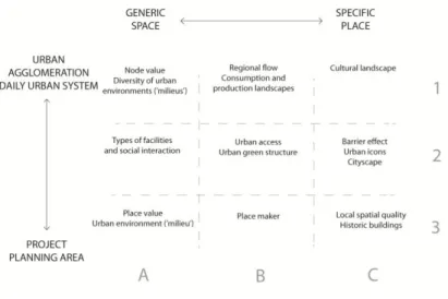
The Plan Review is intended to be applicable in all these cases. This implies that it must provide spatial information on scale (large to small) and measure of detail (generic to specific), befitting the nature of the project and the phase of planning and decision-making. These principles together form the entry points of the Plan Review matrix (Figure 1).
The rows of the matrix distinguish between the scales involved in urban projects; from regional to the planning area of an individual project. These scales relate to the policy objectives that the project is to contribute to – objectives that, mostly simultaneously, are set at various levels of governance. The matrix columns distinguish between the available or required types of information or knowledge, from generic to specific.6 The types of knowledge depend on the particular phase of the planning and decision-making process, varying from the earliest to the latest stages.
A number of spatial conditions can be spread over the matrix. These are elaborated in the following section. To present the conditions in an orderly manner, the matrix has been divided into nine cells (three rows, three columns). The conditions have been distributed over the cells.7 In this way, depending on the plan to be assessed, the dialogue between the parties involved can be focused on the relevant conditions. For example, a discussion on a regional project that is still in an early stage of planning is likely to be focused on the cells in the left-hand top corner of the matrix. In cases of much smaller scale projects and for which more details already have been established, the cells in the right-hand bottom corner would feature more predominantly.
In addition, if necessary, conditions in cells spread over the entire matrix can be discussed; for instance, in cases of urban projects that involve various scales (e.g. local business locations near national motorway slip roads). Talks between stakeholders and plan assessors may follow a certain ‘route’ over the matrix.
4. The Plan Review matrix
4.1 The cells: diverging spatial conditions
On the basis of literature research (e.g. on urban development, architecture, planning, geography, urban sociology and spatial economy), planning and map analyses, field studies and expert interviews, we assembled a series of 16 conditions that regularly feature in spatial research and design.8
The matrix needs to contain various conditions, as objectives of urban projects also differ, and because projects are realised within cities that differ in characteristics as well as for different target groups (context sensitivity). This must involve both
6 In geographic terms, this would be space and place. Experience has shown that more abstract knowledge often is of a
quantitative nature, whereas concrete knowledge can be labelled as qualitative. However, the reverse may also be true.
7
The division in rows and columns is heuristic, for the purpose of easy applicability in assessments. Because the two axes of the matrix both represent a continuum, this division in rows and columns may seem somewhat contrived. Conditions cannot always be easily allocated to any particular cell. Therefore, cell boundaries are represented by dotted lines.
8 There may be considerable differences between traditions directly related to various types of knowledge and know-how. For
research that is based more on the classic (beta) science, the emphasis is on legalities and constants, whereas design research focuses more on options and possibilities within specific contexts. In addition to theory, also practical experience may form a valuable source of knowledge. Although some scientific researchers are less inclined to award appropriate value to such physical rather than scientific knowledge, the necessity of ‘thinking through making’, ‘knowing-in-action’ and ‘reflection-in-action’ have a solid basis in scientific theory (e.g. see Schön, 1984, 1987; Sennett, 2008).
physical and functional aspects of the urban environment, as well as the manner in which city dwellers experience their surroundings. These separate elements are important in isolation, but also their interconnection is significant; together, they determine how cities are used and experienced.
In addition to these dimensions of use and experience, also the time dimension is of great importance in project analysis. After all, analyses of urban investments do not represent one moment in time, but need to consider long-term developments. They must assess the degree to which these projects may adapt to changes, both expected and unforeseen.9 Furthermore, also the short term is of interest, in relation to a project’s planning and execution. This includes the circumstances under which a project can be realised and how the speed with which this happens could be increased (e.g. catalysed).
In order to address these issues in a planning assessment, we included a number of variables related to the planning process in the matrix. However, these process variables (e.g. flexibility, resilience, catalysts, phasing) have not been separately entered into the matrix, but may be addressed in all cells.
The chosen series of conditions is not exhaustive. It was constructed to fit a broad range of projects, while being sufficiently ordered and accessible to function as a checklist in actual practice. Figure 2 shows this series of conditions, as they are distributed over the matrix.
Figure 2. The Plan Review matrix
The following section provides a characterisation of all conditions, centred around certain questions that are subsequently elaborated on. Section 5 describes one of the conditions in greater detail, to provide an example of how conditions may be used in
9 Flexibility and resilience are very important in Dutch contemporary planning practice, as urban development currently is
struggling with large financial difficulties (short term) and sizeable uncertainties (long term) about, for example, economic and demographic developments.
discussions during the planning and decision-making process, to objectify the planning analysis and to structure the communication with stakeholders. In addition, attention is given to certain theoretical backgrounds and methods that enable the use of the Plan Review in the planning and decision-making process.
4.2 Node and place values (1A and 3A)
Are node value and place value sufficiently balanced? The node and place value concept (Bertolini, 1999) offers starting points for the analysis of development options for mobility in connection with those for the functions of an infrastructural node, related to visiting and accommodation. Certain questions are important, such as whether the transport capacity of a node is being used fully, in view of its position within the network, and whether this node value is balanced with the place value – the facilities in the direct vicinity of the node, such as numbers of shops, offices and/or residential homes.
4.3 Diversity of urban environments (‘milieus’) (1A)
What would the project contribute to the existing variety of environments within an urban region? In order to meet the needs of a variety of users (dwellers, workers, visitors), urban regions must contain various types of places and functions, together described as ‘urban environments’ (or ‘urban milieus’) (for elaboration of this concept, see Ritsema van Eck et al., 2009; PBL, 2010; Hamers, 2011). By considering the regional-urban diversity of environments, arguments can be found for possible changes (additions, restructuring, transformations) required in the light of the particular objectives. Here, regional coherence is especially important. Consideration of a project on that scale may indicate the relationship between both competitive and complementary environments (within as well as outside the municipality where the project is being realised).
4.4 Regional flow (1B)
Would the infrastructure on a regional scale be sufficiently robust and/or resilient to manage passenger and freight traffic in the long term, and would it be able to adapt to possible changes in traffic flows, such as increasing cross-traffic in a polycentric region, or decreases due to regional population decline? This includes parallel infrastructure on connecting routes, connections between suburban centres and choice options for either public transport or passenger vehicles. Another issue is whether measures that could be implemented in the short term to create flexibility (e.g. changes in timetables or by the construction of rush-hour lanes) would offer the required solutions.
4.5 Consumption and production landscapes (1B)
How does regional urbanisation relate to landscapes and nature (biodiversity, ecological passages)? Does the landscape in the urban region offer any possibilities
for water storage, in view of climate change? And is it able to meet urban demands related to regional and local food and energy supply, as well as recreation? In addition to existing and inherent natural qualities, this also relates to planned and still to be designed conditions in the consumption and production landscape.
4.6 Cultural landscape (1C)
To which extent have possible particular and unique area characteristics been taken into account? Does the project protect such characteristics or even use them by awarding them a visible position within the project? Depending on the situation, both conservation and development may offer possibilities. If the cultural landscape stretches over a large area, harmonisation between project plans on a regional scale may offer opportunities for making complementary choices in various different locations within the region. For example, if historic patterns at a certain location become unrecognisable due to the realisation of a plan, their conservation elsewhere could be guaranteed.
4.7 Types of facilities and social interaction (2A)
Do cities and neighbourhoods have appropriate facilities, and are these sufficiently accessible? Facilities, including social facilities, together with the public space, form the social-spatial infrastructure of a city. This may connect people. Also, people may feel at home in an environment if they feel connected to it. This may cause them to feel more responsible for maintaining the environmental qualities of the public space. Facilities do need to be easily accessible and fit with the environmental identity (visibility, fitting atmosphere), in order for people to feel involved (see Bromm et al., 2011).
4.8 Urban access (2B)
Are entry and exit roads and light rail or rail connections, on an urban scale, sufficiently robust and/or resilient to continue to process passenger and freight traffic, in the long term, and to adapt to possible changes in traffic flows? Are there any options for separating through traffic from local traffic on urban ring roads (see also 1B)? And will there be sufficient flexibility in the short term? These questions play a role, specifically, for plans relating to housing and business development within the existing city and along the urban fringe. Further urbanisation within existing urban areas mostly makes demands on infrastructure that are different from those of new housing in expansion areas.
4.9 Urban green structure (2B)
How do built-up areas relate to green areas in and around the city? How easy is it for city dwellers to reach these areas of urban green? These questions have different answers in different urban environments (see 3A). Various types of urban dwellers have varying preferences with respect to functionalities and types of greenery (e.g.
recreation, urban agriculture) . The ratio between ‘red’ and ‘green’ also not only refers to magnitude, but also to characteristics. The size of a park, for example, is not automatically an indication of its quality.
4.10 Barrier effect (2C)
What are the options for clearing spatial (and functional, socio-economic and mental) obstacles within a plan? Barriers come is all shapes and sizes; for example, in the form of an infrastructural bundle that separates city areas, or a long and closed front of buildings that forces pedestrians to take a detour. This may cause locations that are physically very close to appear very far away, both in travel time and in perception. Such characteristics can have a large effect on the particular meaning of a place, and, thus, on its value. Clearing such barriers can be a project’s main objective, but it may also be a side effect of developments that primarily serve a different purpose.
4.11 Urban icons (2C)
What could an icon contribute, in comparison to a plan with a fairly plain character? Although icons, by nature, possess a certain uniqueness, there are ways to analyse them. For example, they are rarely realised within a vacuum, but rather are adapted to their existing surroundings, in which often additional investments take place. This connection offers starting points for an analysis of the planned icon, and concerns the convincing logic of the plan as a whole. In addition to its functional value, especially its perceptional value needs to be substantiated. For example, will the icon evoke feelings of pride or identification, or will it mark the entrance of a certain area or connect two areas?
4.12 Cityscape (2C)
To which degree does the plan take into account the presence of a possible historic cityscape? Does the project protect such characteristics or even use them by awarding them a recognisable position within the project? Local historic characteristics of a city district or neighbourhood may offer starting points for creating a visible identity in a plan. This may enhance a project’s attractiveness to residents, businesses and visitors (depending on the planned programme) and offers possibilities for branding.
4.13 Urban environment (‘milieu’) (3A)
Which spatial and functional conditions are offered by the planned environment (‘urban milieu’) in order to achieve the related policy objectives? When changes to the range of environments within an urban region would contribute to achieving a certain policy objective (see 1A), the focus can be turned to the type of environment that would be needed to realise this change. The main question, here, would be that of which conditions are offered within the planned environment for realising the policy objective, taking into account possible tensions between objectives in different
fields of policy, of different municipalities in the region, and of different layers of governance. This also applies to options for urban milieu development contributing to a mutual enhancement of policy objectives.
4.14 Place maker (3B)
How can the transformation of a space into a place in locations with multiple problems be encouraged? We distinguish between three options. Firstly, the so-called ‘golden key’: could the plan be altered in such a way that qualities that are difficult to unify can be developed with a certain connection? Changes may affect both the programme and the spatial design. In some cases, a breakthrough in routine thinking can create space for new solutions with a broad support base. In these cases, puzzles are not pieced together again, but the puzzle itself is altered. Secondly, could pioneers give an extra impulse to the (re)development of an area? Plans may become stalled for various reasons in certain parts of a city, causing some areas to remain undeveloped for long periods of time, and resulting in the postponement of desired changes. Quite often, these ‘interim’ periods last for many years. Pre-investments in programmes and buildings (e.g. events, studios and workshops, and meeting places), as well as temporary permissions for unconventional use of space (e.g. urban agriculture) or unconventional urban development (e.g. experimental, organic architecture) may be catalysts for change or accelerate changes. Thirdly, could the project be carried out in phases (in consecutive steps)? In the current Dutch debate on uncertainties around projects, phasing is considered as a way of reducing financial risks. However, projects cannot simply be cut into several pieces. It is vital that an estimation be carried out first, concerning the practicality and relevance of such a part-project in the eventuality that the rest of the project is abandoned. In other words, would the first phase of the project have an independent functional-spatial logic, on the basis of which it would contribute to the city?
4.15 Local spatial quality (3C)
Does the plan’s organisation of public space match the planned urban environment (see 3A) and the target audience? Local spatial quality – for lack of a better term – cannot be described in general terms but must be related to, for instance, location, existing functions, density and building heights. For a square, for example, sun and lighting would be important, in addition to shelter from the wind and a certain degree of enclosure. Furthermore, also information on the main users would be important; after all, they would make different demands on the location. For example, visitors to a certain place would look for entertainment, while residents may seek rest and quiet at the same location. In addition to a pleasant outside space, also local conditions for traffic circulation, as well as social safety and road safety may play a role.
4.16 Historic buildings (3C)
How does the plan deal with cultural heritage, on building level? Are choices being made solely with respect to preservation of protected historic monuments, or do such
historically valuable and characteristic buildings offer starting points for new development? Could they provide a project with some coleur locale, or even serve as centrepieces for the development of a recognisable, local identity for the surrounding areas (see also 2C)?
4.17 Various functions of the matrix in the dialogue with stakeholders
This list, as indicated above, may be used as a checklist in the dialogue with stakeholders. Depending on the phase of the planning en decision-making process, this checklist could have various functions. Planners could use the list throughout the development of a project, and subsequently it could also be used in discussions about possible improvement options. Towards the end of the planning and decision-making process, the checklist could become part of the assessment process, as a prelude to the assessment of expected effects and project efficiency, for example (as is current Dutch practice) in the form of a CBA.
The brief explanation of the conditions, as provided above, places the emphasis on the desired spatial development within a project. However, in addition, possible unwanted effects must also be considered. For example, the construction of a new exit/entry road may unwittingly create a barrier between two, previously well-connected areas, within or outside the planning area. Because such effects may create conditions that could hamper the achievement of policy objectives, they must be brought to light early enough to be considered when improvement options are discussed.
5. An example: local spatial quality (3C)
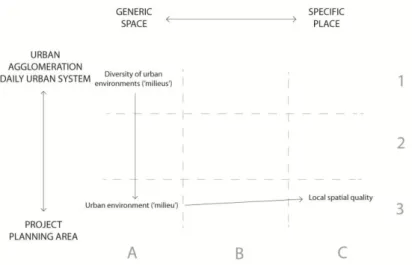
This paper only provides one example: local spatial quality (3C), seeing the limitations to the length of the paper. We provide a concise example of the application of the Plan Review instrument with regard to this particular spatial condition and briefly refer to the theoretic and methodological background. In order to provide a certain context, we have related the spatial quality condition to a current example from Dutch planning practice: the knowledge campus. In the example, a ‘route’ over the matrix is followed, as could be done in the discussions during such a project; from discussing the range of urban environments (1A), via the chosen environment (the campus) (3A), to a discussion on the fitting local spatial quality (3C) (see Figure 3).10
10 The first two steps have not been described here. They are merely mentioned to present the workings of an analysis of the
Figure 3. ‘Route’ over the Plan Review matrix
5.1 High Tech Campus Eindhoven
Imagine an urban region that wishes to develop an internationally competitive business climate, as well as realise knowledge development (e.g. by so-called knowledge spillovers). In addition, imagine that this region could demonstrate that a knowledge campus would be a suitable urban environment to achieve such policy objectives (3A). Now assume that this region could prove that such a campus would be a valuable addition to the existing range of urban milieus and that there will be no inefficient competition with other such milieus in the region (1A). This then leads to the relevant question of which type of local spatial quality would be required for the realisation of the desired knowledge development (3C).
The Dutch city of Eindhoven, the centre of the so-called Brainport region of the Netherlands, is home to the High Tech Campus. This campus houses dozens of knowledge-intensive businesses. This concentration of such businesses fits with the strong tradition in R&D in the Eindhoven region, and with regional and national ambitions in the field of knowledge development.
The campus set up gives shape to the chosen principle of ‘open innovation’, which centres around cooperation. Businesses on the campus all focus on their particular specialism, but they are expected to inspire each other by sharing knowledge and experience and by making use of the same facilities. The underlying thought is that, in this way, innovation not only occurs at a faster and cheaper rate, but also will be of better quality (www.hightechcampus.nl).
5.2 Shared facilities
The main question in relation to the local spatial quality on campus could be whether the public space is organised in such a way that it meets the needs of the knowledge workers (the campus target group) and achieves the objective of stimulating the
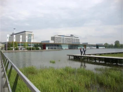
exchange of knowledge. One of the principles of the campus is that knowledge workers must be able meet in a casual manner and in a comfortable environment. To facilitate this principle, the campus has a centrally located, shared boulevard, along which a number of bars and restaurants are situated, as well as a conference centre, a wellness centre and some shops (‘The Strip’, see Figure 4). Although this boulevard with its facilities is no guarantee that people will meet, it does provide the conditions that encourage such encounters. In order to achieve these, facilities need to be inviting, which may be achieved by the shop windows’ seductive and transparent exterior, and by the clever positioning of entrances in relation to the public space and passage ways.
Figure 4. High Tech Campus Eindhoven: shared facilities and lounge chairs on The Strip
5.3 Organisation and materialisation of public space
Public space design (spatial organisation and materialisation) also contributes to the conditions that encourage encounters. This includes benches, lighting and other street furnishings, pavement types and the presence of grass and trees. Local spatial quality must correspond with the needs of the main user groups. The High Tech Campus knows only one type of user: knowledge workers, national and international, with a technical background. They visit The Strip during their lunch breaks or for meetings, and particularly seek out environments that differ from their workplace. In the designing of the public space, the fact that these researchers usually like greenery and comfort was taken into account. Therefore, The Strip was not shaped to reflect a
historic European inner-city style, but rather accentuates the natural aspects of the surroundings. The pond takes up a central position in the design and offers a broad view from the lounge chairs placed around it. There are also wooden jetties, benches and bridges, creating a variety of places to sit and wander around (see Figure 5).
Figure 5. High Tech Campus Eindhoven: The Strip and walking route around the pond
In addition to a pleasant public space (due to walking routes, greenery and meeting places), the security of campus laboratories is, of course, also important. This requires a focus on the effects from the various design elements on their surroundings. For example, a high steel fence would have a very different effect on passers-by than would a glass door that is electronically secured.
5.4 Traffic access
Finally, there are local conditions which are important for traffic circulation.11 The park-like campus contains many paths for walking or cycling. All around campus, bicycles have been placed for people to travel quickly from building to building. Moreover, this system of paths is connected to bicycle paths that lead to green areas outside the campus, and motorised traffic is efficiently routed to and from a separate motorway slip road towards the ring road along the outside boundary of the campus. All car parks are located directly off this ring road.
5.5 Guidelines and reference projects
Theoretical and empirical knowledge about the spatial quality of public spaces has been documented in handbooks. A number of urban designers and sociologists have
studied a variety of squares, parks and streets, and documented their main aspects (e.g. see Cullen, 1961; Gehl, 2001; Jacobs, 1961; Jacobs, 1993; Lynch, 1960, 1988). Notable fact is that these studies name best practices but do not formulate rules for constructing what could be seen as ‘good’ public spaces. This may be explained by the fact that each location, function and user target group is different; every situation requires its own approach.
However, this does not mean that projects cannot be compared. Although the appropriate spatial quality of a certain area cannot be determined using a general formula, this could be determined from reference projects; a comparison between the planned project and related, already finished projects elsewhere. Questions related to which actions were successful and which were not (ex-post analysis) are important to ask, as well as making certain that the reference projects match the planned project in type of urban milieu, magnitude and situation within the urban region.
Another notable fact is that a large part of available knowledge on attractive public spaces is related to a specific type of urban environment: the pedestrian areas in typical European cities. Examples are the historic Parisian boulevards, Italian renaissance cities and contemporary gentrified neighbourhoods, such as the London mews. Diversity and being small-scaled are important characteristics of these prototypes of urban environments. To date, is has been difficult to find handbooks that offer an alternative for these singular (cliché-like) references of spatial quality and urban identity. Complementary documentation of innovative examples of the spatial quality of other types of environments would contribute to the improvement of analyses and assessments of urban projects.
6. Synthesis
By introducing the Plan Review instrument, the communication on urban projects could be made more transparent, and thus contribute to improvements in planning and decision-making processes around urban investments.
Insight into the specific environment of a project location is vital to the assessment of urban plans (context sensitivity). In addition, there is a need for a system of analysis that would be widely applicable (scope, repeatability), and uses clear considerations (transparency) that are comprehensible to the wide variety of stakeholders (communication beyond the boundaries of individual disciplines).
The Plan Review meets the combined needs for context-specific knowledge and a system. It features a series of 16 spatial conditions that a project has to meet in order to achieve policy objectives (possibly at various governance levels and in different fields). This series is presented in a matrix, from which relevant conditions can be chosen, per case. This matrix may help to structure the dialogue with stakeholders, and maximise the objectification of plan analysis. Depending on the phase of the planning and decision-making process, the Plan Review may improve urban planning
and contribute to the related spatial assessment, in light of the particular policy objectives.
7. Discussion
The Plan Review has been developed on the basis of knowledge and know-how from various spatial disciplines. It deviates from the welfare economics approach of CBA – the instrument most used in the Dutch assessment process. The Plan Review is not intended as an alternative to CBA, but rather as a complementary instrument. Because of its deviating theoretic and methodical basis, a successful application of the Plan Review would require a team with a different composition of disciplines than present in the teams that currently mostly assess project plans. The application of this instrument requires a multidisciplinary team that represents both knowledge and experience in spatial research and design.
This new instrument as presented in this introduction, probably has not yet reached its definite form. In the coming period, practical application will test its usefulness, and further discussions with a wide variety of users may help to fine-tune the instrument. Initially, attention should be paid to the relationship between plan optimisation and plan assessment; looking at which aspects are focused on in which phase of the planning and decision-making process. Another area of attention should be the relationship between the Plan Review and the CBA. Because of the CBA’s focus on effectiveness and efficiency of a project, and the Plan Review’s focus on the conditions under which a plan could be most effective, we recommend that application of the Plan Review would precede the CBA. Actual practice will show whether this approach indeed delivers positive results. A third aspect that deserves particular attention is the weighing of the conditions as entered into the matrix. In its current form, the matrix does not provide any ranking. The parties involved choose the most relevant conditions, depending on the nature of the project. Further research as well as practical experience could indicate whether the possible incommensurability of various conditions would stand in the way of clear decision-making, and if there is a risk of cherry picking.
8. References
Bebbington, J., Brown, J. and Frame, B., 2007. Accounting technologies and sustainability assessment models. Ecological Economics, 61, pp.224-36.
Bertolini, L., 1999. Spatial development patterns and public transport: the application of an analytical model in the Netherlands. Planning Practice & Research, 14(2), pp.199-210.
Bromm, S., E. Vreeswijk en R. Wiggers, 2011. Sociaal ruimtelijke ambities: verankering sociaal met fysiek. Plan Amsterdam, (3), pp.4-13.
Gehl, J., 2001. Life between buildings: using public space (5th edition). Kopenhagen: Danish Architectural Press.
Hamers, D., 2011. The fringe in focus. A mosaic of urban milieus as the basis for a regional planning approach to urban development. In International Forum on Urbanism (IFoU), Proceedings of Global visions. Risks and opportunities for the urban planet. 5th Conference of the IFoU. Singapore: IFoU.
Jacobs, A., 1993. Great streets. Cambridge, MA: MIT Press.
Jacobs, J., 1961. The death and life of great American cities. New York: Modern Library.
Lynch, K., 1960. The image of the city, Cambridge, MA: MIT Press. Lynch, K., 1988. Good city form, Cambridge, MA: MIT Press.
Municipality of Almere and Ministry of Infrastructure and the Environment, 2011. Verslag MKBA-symposium: tussen methodiek en politiek. Den Haag/Almere: Ministry of Infrastructure and the Environment and municipality of Almere.
PBL Netherlands Environmental Assessment Agency, 2010. De staat van de ruimte 2010: de herschikking van stedelijk Nederland. The Hague/Bilthoven: PBL.
Renes, G., A. van Hoorn and D. Hamers, 2011. Verbetering van de communicatie en presentatie rondom de MKBA bij verstedelijkingsprojecten. The Hague/Bilthoven: PBL.
Ritsema van Eck, J., H. van Amsterdam and J. van der Schuit, 2009. Ruimtelijke ontwikkelingen in het stedelijk gebied: dynamiek Stedelijke Milieus 2000-2006. The Hague/Bilthoven: PBL.
Schön, D., 1984. The reflective practitioner: how professionals think in action. Aldershot: Ashgate.
Schön, D., 1987. Educating the reflective practitioner: toward a new design for teaching and learning in the professions. San Francisco: Jossey-Bass.
Sennett, R., 2008. The craftsman. London: Allen Lane.
Tribe, L., 1972. Policy science: analysis or ideology. Philosophy & Public Affairs, 2(1), pp.66-110.