Report 680704010/2009
P.L. Nguyen | R. Hoogerbrugge | F. van Arkel
Evaluation of the representativeness
of the Dutch national Air Quality
Monitoring Network
RIVM Report 680704010/2009
Evaluation of the representativeness of the Dutch national
Air Quality Monitoring Network
P.L. Nguyen R. Hoogerbrugge F. van Arkel
Contact:
R. Hoogerbrugge
Advisory Service for the Inspectorate, Environment and Health Ronald.Hoogerbrugge@RIVM.nl
This investigation has been performed by order and for the account of the Ministry of Housing, Spatial Planning and the Environment (VROM), within the framework of the Dutch national Air Quality Monitoring
© RIVM 2009
Parts of this publication may be reproduced, provided acknowledgement is given to the 'National Institute for Public Health and the Environment', along with the title and year of publication.
Abstract
Evaluation of the representativeness of the Dutch national Air Quality Monitoring Network
As a general rule, the Dutch Air Quality Monitoring Network (LML) is representative for the
Netherlands. They fulfill the criteria of EU Directive 2008/50/EC for representativeness of measurement sites. However, the Dutch classification of measurement sites, which is a simple classification with only three types of stations, rural, urban background and street, does not always positively correlate to the measurement data. Any interpretation of the measurements of the LML must take this aspect into consideration.
A number of rural stations were found to have peak concentrations for one component, for example ammoniac in Vredepeel as a result of agricultural activities in this area, and a number of street stations are actually located on a highway (for example at Breukelen). In addition, rural station in an urbanized area had distinctly higher concentrations than other rural stations, while one station in a suburb of Groningen had lower concentrations than urban stations located in the western industrialized area of the Netherlands. At one measurement station, the flow around the inlet was obstructed by a close building, while at other locations, the flow around the inlet was affected by trees (which have been since pruned). These are the conclusions of the evaluation of the representativeness of the LML which has been
performed by the RIVM by request of the Ministry of Housing, Spatial Planning and the Environment (VROM). For this study, measurements data of the RIVM from 2007 of nitrogen oxide, nitrogen dioxide, carbon monoxide, particulate matter, ozone, ammoniac and sulfur dioxide were used. The results of this screening were then compared with the screening that used data from 1994; this comparison served as a check of the consistency of the observed results which seems to be good. The effect of pruning overgrown trees at two locations was studied in more detail and in both cases, no effect on the concentration was found. To prevent any obstruction of the air inlet it is recommended to prune trees which grow in close proximity to monitoring stations.
Key words:
Rapport in het kort
Evaluatie van de representativiteit van het Landelijk Meetnet Luchtkwaliteit
In het algemeen zijn de meetlocaties van het LML representatief voor Nederland. Ze voldoen hiermee op dit onderdeel aan de Europese Richtlijn 2008/50/EG. Wel sluit de eenvoudige Nederlandse
standaardindeling in drie type stations, regionaal, stadsachtergrond en straatstations, niet bij elke situatie aan. Bij de interpretatie van resultaten van het LML moet hiermee rekening worden gehouden.
Zo is er bij enkele regionale stations een piekwaarde voor één stof gemeten, zoals ammoniak in Vredepeel als gevolg van landbouwactiviteiten in de omgeving. Ook bestaan er straatstations buiten de stad waarbij meetlocaties langs de snelweg lopen, zoals bij Breukelen. Daarnaast vertonen regionale stations in een verstedelijkt gebied hogere concentraties dan andere regionale stations. Tegelijkertijd vertoont een voorstadstation bij Groningen juist lage meetresultaten ten opzichte van stedelijke stations in de Randstad. Voor één locatie wordt de ‘vrije aanzuiging’ van lucht, die nodig is voor de metingen, gehinderd door een nabij gelegen gebouw. Op een aantal locaties werd de aanzuiging gehinderd door bomen, die inmiddels zijn gesnoeid.
Dit blijkt uit een evaluatie van de representativiteit van het LML die het RIVM in opdracht van het ministerie van VROM heeft uitgevoerd. Hiervoor zijn meetdata van het RIVM van stikstofoxide, stikstofdioxide, koolmonoxide, fijn stof, ozon, ammoniak en zwaveldioxide uit 2007 gebruikt. Om de consistentie van de resultaten te checken, zijn ze vergeleken met de metingen uit 1994, die overeen bleken te komen. Specifiek is gekeken naar het effect van het snoeien van uitbundige begroeiing op een tweetal locaties. In beide gevallen is geen effect op de concentraties waargenomen. Om vrije aanzuiging van lucht te waarborgen, wordt toch aanbevolen te snoeien.
Trefwoorden:
Contents
Summary 91 Introduction 11
2 Documentation of the Dutch Air Quality Monitoring network 13
3 Study of the micro and macro status of the stations 15
3.1 Criteria for selection of the monitoring sites 15
3.2 Quick scan of the monitoring sites 15
3.2.1 Traffic-orientated sampling sites (kerbside) 15
3.2.2 Urban background sampling sites 16
3.2.3 Rural sites 16
3.3 Good housekeeping 16
4 Study of the representativeness by means of principal component analysis 17
4.1 Method 17
4.1.1 Principal component analysis 17
4.1.2 Scaling and centring 17
4.1.3 Data sets 17
4.2 Screening results using data from 2007 19
4.2.1 NO2 19 4.2.2 NO 26 4.2.3 PM10 28 4.2.4 CO 30 4.2.5 NH3 31 4.2.6 O3 33 4.2.7 SO2 35
4.3 Analysis performed with data from an earlier year (1994) 37
4.3.1 NO 37 4.3.2 NO2 38 4.3.3 PM10 39 4.3.4 CO 40 4.3.5 NH3 41 4.3.6 O3 42 4.3.7 SO2 43
4.4 Pollutants from traffic 44
4.4.1 Combination of NO and NO2 44
4.4.2 Combination of NO, NO2 and CO 45
4.5 Agriculture-related pollutant (NH3) 47
4.6 Conclusions of the screening by means of PCA 47
7 Conclusions 57
References 59
Appendix 1 Criteria on micro and macro scale 61
Appendix 2 Quick scan of the Dutch national Air Quality Network 63
Appendix 3 Calculation of average concentration rose 67
Appendix 4 Locations of sites 938 in Groningen 69
Appendix 5 Location of site 741 in Nijmegen 71
Appendix 6 Old location of monitoring station 445 (Den Haag-Veerkade) 73
Appendix 7 Diurnal variation of NH3 75
Appendix 8 Average NH3 concentration roses of 131 (Vredepeel) and 738 (Wekerom) 79
Summary
By request of the Ministry of Housing, Spatial Planning and the Environment (VROM) the RIVM has evaluated the representativeness of the Dutch national Air Quality Monitoring Network (LML). Two studies were performed in parallel within the framework of this evaluation: an assessment of the micro/macro scale of the monitoring sites and a screening of the measurement results by principal components analysis (PCA) in combination with other techniques (wind roses and diurnal analyses). The study of the micro/macro scale compared the monitoring sites with the criteria of the Directive; the PCA analyses identified sites that were notably distinguishable from other sites within their own
classification. Additional measurement techniques, such as wind roses and diurnal analyses and the Google Map application (photographs of the direct vicinity), were used to analyse the observed distinguishing parameters in more detail. For this study, the measurements of nitrogen oxide (NO), nitrogen dioxide (NO2 ), carbon monoxide (CO), particulate matter (PM), ozone (O3 ), ammoniac (NH3 ) and sulphur dioxide (SO2 ) for 2007 were used. The results of this screening of 2007 measurement data were also compared to the results from the screening of the measurement data for 1994 – as a check on the consistency of the observed results.
The evaluation reveals that, in general, the LML fulfils the criteria of the EU Directive 2008/50/EC very well and that the character of the stations has not been changed over the last 13 years. No irregularities were observed in the measurements for NH3 (all at rural stations). The overgrowth around stations 722 (Eibergen) and 520 (Amsterdam–Florapark), which was removed in 2007-2008, did not result in noticeable trends in the concentrations measured at these stations.
The evaluation also identifies a number of issues that require attention, leading to the following recommendations:
• Good housekeeping: trees which grow in close proximity to monitoring stations have to be pruned regularly to prevent obstruction of the inlet.
• The vegetation around stations 722 and 520 should be pruned regularly.
• The location of site 137 may not be optimal for the measurement of urban background concentrations because this station is located very close to a building and a representative sampling of air from a large area can not be guaranteed. Because the data analysis has not proven that the current location affects the representativeness of this station, it is not necessary to replace this station immediately. However, when this station is renewed, the new monitoring station should be placed at a more suitable place in this area.
• Classification: compared to the AIRBASE classification, the Dutch classification is simple. The PCA analysis shows that the more sophisticated AIRBASE classification provides a more precise description for a number of stations in the LML. This aspect is very relevant and should be taken into account when the measurement data are interpreted or used for validation.
- Street station 641 (Breukelen–snelweg ) is located on a highway and clearly differs from the other street stations. This difference is reflected in airborne background concentrations. The classification Rural Traffic is more representative.
- Street station 545 (Amsterdam–A10 west) is located on a highway and differs clearly from other street stations.
- Station 938 (Groningen–Nijensteinheerd) is classified as an urban background (UB) station (suburb for O3), but it is clearly different from other urban stations in more densely populated areas.
are currently not shown in the Google Maps application. Completion of this application by adding the omitted sites is necessary.
1 Introduction
In accordance with EU legislation, the air quality in the Netherlands is monitored by the Dutch national Air Quality Monitoring Network (LML). The stations are classified as rural-, urban background-
respectively street stations. For air quality data from different stations to be comparable, monitoring sites must be representative. By request of the Ministry of Housing, Spatial Planning and the Environment (VROM), the National Institute for Public Health and the Environment (RIVM) has assessed the representativeness of this monitoring network. This evaluation comprised two studies performed in parallel:
• A study of the micro/macro status of the stations.
• A study of the representativeness of the classification using the following strategy:
- screening of the measurement results by means of PCA (principal components analysis) - selection of extreme results or results that may be inconsistent with other results
- detailed analyses of the selected measurement locations according to wind rose, diurnal variations and other analyses
The measurement data on NO, NO2, CO, PM, O3, NH3 and SO2 for 2007 were screened and the results compared to the screening of the data for 1994 as a check of the consistency of the observed results The results of these studies are presented in this document where they are used for evaluating the representativeness of the measurement stations for the various components. The results also form the basis for recommendations regarding various actions that can be undertaken, such as maintenance work/pruning of vegetation, among others.
2 Documentation of the Dutch Air Quality
Monitoring network
The directive 2008/50/EC on ambient air quality and cleaner air for Europe (subsequently referred to as ‘the Directive’) includes criteria relevant to the documentation and review of site selection. The following statement is found in Annex IIID of the Directive:
‘The site-selection procedures shall be fully documented at the classification stage by such means as compass-point photographs of the surrounding area and a detailed map. Sites shall be reviewed at regular intervals with repeated documentation to ensure that selection criteria remain valid over time’. One proposal is for a review of the DAQMN at regular intervals of 5 years.
Documentation in 1998 and 2002/2003 has been compiled and recorded in the archives. A Google Maps application was utilized for an update of the documentation and a review of the site selection. The application shows:
• exact compass points
• at least four photographs of the direct vicinity
• (optional) one panorama photograph of the site (a photograph from the roof of the cabin) Almost all of the existing sites of the Dutch national Air Quality Monitoring Network and a selection of monitoring sites of local authorities are shown in the application.
The link to this application is:
3 Study of the micro and macro status of the stations
3.1 Criteria for selection of the monitoring sites
The Directive provides a distinct description of the criteria to be satisfied in terms of the positions of sampling points used for the evaluation of ambient air quality. These criteria are stated in Annex III of the Directive.
The Directive distinguishes between micro- and macro-scale siting requirements for sampling points, with different criteria for each scale. These criteria are given in Appendix 1 of this report. In short, the criteria include:
• unrestricted airflow
• no sources in the immediate vicinity of the site • inlet height between 1.5 and 4 m
• for all pollutants, traffic-oriented sampling probes shall be at least 25 m from the edge of major junctions and no more than 10 m from the kerbside
The criteria to be applied depend both on the compounds of interest (for example, O3 and PM) and the scope of the measurement strategy, such as:
• traffic related • urban located
• protection of vegetation
• point sources or diffuse sources
3.2 Quick scan of the monitoring sites
3.2.1 Traffic-orientated sampling sites (kerbside)
One restriction in the Directive for traffic-orientated sampling of SO2, NOx, PM, lead, benzene and CO in ambient air is that the measurement site must be at least 25 m from the edge of major junctions and no more than 10 m from the kerbside. In the case of a highway (motorway) where a kerbside is not
available, this review has chosen a distance of at least 30 m from the edge of the highway.
There are 17 traffic-oriented sampling sites in the LML, all of which are located at least 25 m from the edge of major junctions and no more than 10 m from the kerbside. Consequently, all of the criteria stated in the Directive for traffic-oriented sampling points are fulfilled. Sites 136 (Heerlen–Looierstraat) and 447 (Leiden–Willem de Zwijgerlaan) require some maintenance work because of (temporary)
obstruction of the inlet tube (due to trees)
.
The O3 concentrations are also measured at several traffic-orientated locations for modelling purposes. In accordance with the criteria for evaluations of O3 concentrations, as stated in Annex VIII of the Directive, the O3 concentrations measured at these sites are not used for evaluation of the air quality.
3.2.2 Urban background sampling sites
The environmental limit values are set for the protection of human health. Consequently, the urban background locations are of especially interest. The Directive states that the urban background locations shall be located so that their ‘pollution level is influenced by the integrated contribution from all sources upwind of the station. The pollution level should not be dominated by a single source unless such a situation is typical for a larger urban area. Those sampling points shall, as general rule, be representative for several square kilometres’.
The evaluation reported here is based on expert judgment. One recommendation aimed at improving the 2014 review is to adjust the set of evaluation criteria when an urban background location is typical of a larger urban area. For example, the criteria should take the wind directions into account. In the
Netherlands the PM-limit values are mainly exceeded under conditions of a calm easterly wind. The most common wind direction is, however, (south) westerly and consists of higher parts of sea salt, which is probably of less interest in terms of an effect on human health.
The urban background sampling sites in the LML are not dominated by a single source, and they are representative of several square kilometres. However, a number of sites clearly require some
adaptation/maintenance work; for example, the flow around the inlets may not be unrestricted, or there may be an external structure (such as buildings or trees) that directly influences the measurements. Such sites are 137 (Heerlen–Nicolayestraat), 418 (Rotterdam–Schiedamsevest) and 520 (Amsterdam–
Florapark). The location of site 137 is not optimal for taking measurements of urban background concentrations because this station is located very close to a building and, consequently, a representative sampling of air from a large area cannot be guaranteed. The overgrowing trees at station 520 were pruned in 2007, and the current situation meets the requirements for unrestricted air flow. The criteria for classifying and locating sampling points for the evaluation of O3 concentrations as mentioned in Annex VIIIB of the Directive “to ensure the inlet probe is well away from such sources as furnaces and incineration flues and more than 10 meters from nearest road, distance increasing as a function of traffic intensity” are fulfilled by the urban background stations of the LML.
3.2.3 Rural sites
The rural sites are positioned such that the protection of human health and vegetation can be assessed. The sites are therefore located in small settlements or open-area sites. The sites have to be representative on a regional scale. In this review, the compass-point-photographs plotted in a Google Maps are used for the evaluation.
The results of the Quick scan are shown in Appendix 2.
3.3 Good housekeeping
To guarantee that the position of the measurement sites and the criteria as specified in the Directive are fulfilled, a strict protocol for ‘Good Housekeeping’ of the DNAQMN is needed. A number of factors may necessitate that the measurement locations be changed, such as the renovation/urban development of an area or micro-scale changes.
4 Study of the representativeness by means of
principal component analysis
4.1 Method
4.1.1 Principal component analysis
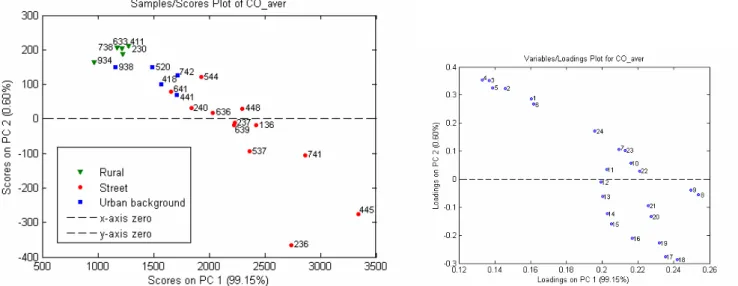
In the screening analyses, a typical data set consists of a matrix of 40 stations × 8760 hourly values. The information can therefore be described in a mathematical space with at least 40 dimensions. Such a space in itself can not be visualized; to this end, multivariate data visualization tools have been developed. Principal component analysis (PCA) is a well-known data visualization/data reduction tool that is often applied in such large analyses. The first principal component (PC-1) is defined as the linear combination of the original variables that describes the maximum amount of variation present in the data set. The second principal component (PC-2) is similarly defined as the linear combination of the original variables that describes the maximum amount of the remainder of the information found in the data set. This process continues in this fashion for the higher order of components. The samples in this study, i.e. the measurement locations, can be projected on the principal components (PCs). These projections, usually called scores, can be shown as two-dimensional plots; for example, the plot of the scores of PC-1 vs. PC-2, which is the linear two-dimensional projection of the data set with a maximum amount of variation.
In addition, the relation between the original variables and the PCs, usually called loadings, facilitates the interpretation of the phenomena observed.
4.1.2 Scaling and centring
When the variables in the data set a priori equalize in terms of potential information content, a scaling factor is usually applied to the variables to equalize the amount of variation by dividing the data for each variable by its standard deviation. In accordance with this same line of reasoning, without prior
knowledge, the centroid of the data set is usually removed by subtracting of the mean of the data set (mean centring). The combination of centring and scaling is performed using the autoscale function of the PLS Toolbox in Matlab.
If the autoscale operation as described above is applied on the data set with hourly values, the potential influence of each hour on the PCA will be equal. However, if the raw data are used in the PCA, the influence of hours with large concentrations will be larger than that of hours with low concentrations. In extreme cases, the plot may even be dominated by a small selection of hours with high concentrations. The scaling also influences the interpretation of the plots produced. In general, the interpretation of the plots based on PCA without scaling is more straightforward than that of the auto-scaled data.
It is therefore evident that calculations with and without scaling both have their own distinct advantages and disadvantages. Consequently, the data sets are evaluated both with and without scaling.
∑
∑∑
∑
= ≠ = = ≠ ≠ = ≠=
8760 1 ) ( , 8760 1 1 ) , ( , 1 , ( )*
n i n j n n N k i n j k k n N k ik k j ijx
x
x
x
where xij is the estimated concentration of time i at monitoring station j.
For N monitoring stations, this data set is an N-by-8760 matrix.
- Data set of diurnal variation. For each hour, the average concentration over the whole year is calculated .This data set is an N-by-24 matrix.
- Data set of average concentration roses. The wind rose is divided into 12 sectors, and the average concentration in each wind sector is calculated. The data set is an N-by-12 matrix. See Appendix 3 for the calculation of average concentration roses.
Data for 1994 were also analysed to determine whether there have been any major changes during the last 13 years. For this analysis, a PCA method was selected from the above analyses.
Additional analyses that focused on traffic (concatenated matrix of NO and NO2, NO, NO2, CO hourly concentrations) and agriculture (NH3) were also carried out.
4.2 Screening results using data from 2007
The first step in our study of the representiveness of the measurement stations for the selected air quality components was to screen measured concentrations by PCA. As described in the Method section, the screening can be performed using different options for scaling and compressing the measurement data. Here, NO2 will be studied as an example.
4.2.1 NO
2Hourly data: PCA results obtained with autoscaled data and with original data
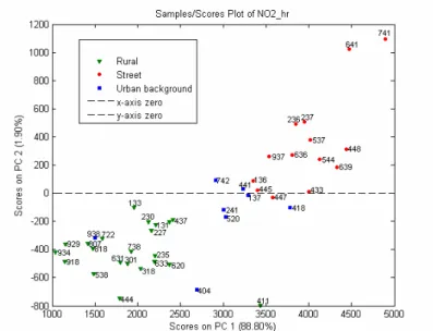
Figure 1 and 2 Scores and loadings plots for the first two PCs for NO2 hourly concentration, with autoscaling of the hourly data. The scores plot shows distinct clusters of stations, a number of stations standing out.
Note: Street station 445 (Den Haag–Veerkade) was out of operation from July 2007 to June 2009 and has been replaced. Since 18 June 2009, this station has once again been in operation; the station has since been replaced and is no longer located in the middle of the street (Appendix 5 shows the old location of station 445).
Figure 3 Scores plot of the first two PCs obtained with PCA analysis using NO2 hourly data without autoscaling. This plot also shows distinct clusters of stations. There are more variations on this plot than on that obtained with autoscaled data (Figure 1).
Figures 1 and Figure 3 show that different scores plots were obtained depending on whether original or autoscaled hourly data were used. When original hourly data are used, the separation occurs along both PCs; when autoscaled hourly data are used, the separation occurs mostly along the PC-1. Despite this difference, the results of both analyses are similar in that both scores plots show clear clusters of different types of stations. However, there are a number of differences as well, including the following:
- Urban background station 938 (Groningen–Nijensteinheerd) resembles a rural station due to is location in a suburb of Groningen (Appendix 4).
- Rural station 411 (Schipluiden) resembles an urban background station. The average
concentration rose of this station (Figure 6) shows that a high concentration is measured at this location when the wind is south-easterly, indicating that this station is influenced by inland activities in the Rotterdam area.
- Urban background station 418 (Rotterdam–Schiedamsevest) resembles a street station. The concentration rose of this station (Figure 6) shows that the NO2 concentration measured at this station is contributed by the Rotterdam harbour.
- Urban background station 520 (Amsterdam–Florapark) differs from other urban background stations (Figure 1) in that the concentration rose of this station (Figure 6) is influenced by the IJ-tunnel.
- Street stations 641 (Breukelen–snelweg) and 741(Nijmegen–Graafseweg ) are clearly different from other stations. The differences at station 641can be explained by the location of this station on a highway; as such, it is not a ‘normal’ street station. Station 741 is located nearby a traffic circle, but the distance from the monitoring station to the traffic circle is about 100 m (see Appendix 5). Consequently this location still satisfies the criteria in the Directive for traffic-orientated monitoring stations.
The advantage of Figure 3 over Figure 1 is that the former provides the possibility to make a straight forward interpretation. In Figure 3, the distance of the projections from each station to the origin of the plot (PC-1 = 0, PC-2=) is correlated with the average concentration. In addition, the projection of the hours on the PC is correlated with the average concentration for that hour. The autoscaling in Figure 1 has resulted in such interpretations being relatively more complex. An obvious disadvantage of both
Figure 1 and Figure 3 is the interpretation of the projection of the hours on the PCs (loadings). Due to the large number of hourly values (8760), the plots are very crowded. To solve this problem, the number of variables should be reduced, preferably with a minimum loss of information. To this end, we now explore two reduction approaches. The first approach is based on the assumption of diurnal consistency and involves averaging the concentrations for each hour of the days sampled, yielding a data set of 24 variables. The second approach is based on the assumption of consistency in terms of the wind direction during the hour of the measurement
Reduction approach based on diurnal variation: PCA results obtained with and without autoscaling of the data set
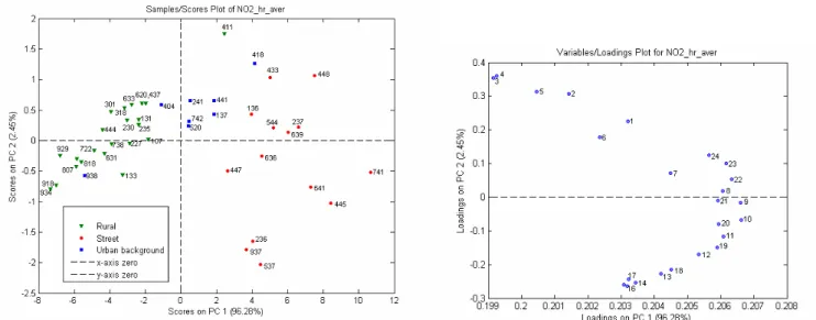
Figure 4A and 4B Scores and loading plots for the first two PCs for diurnal variation of NO2 with autoscaling of the data set.
The scores in Figure 4A again show the street stations (high concentrations of NO2) on the right of the plot and the rural stations (low concentrations) on the left. When combined with the loadings in Figure 4B, all hours are consistently projected on the positive site of PC-1. In the projection of the stations on PC-2, the positive site is dominated by stations in the Rotterdam area (411, 418, 433 and 448), while a number of street stations throughout the Netherlands (236, 937 and 537) dominate the negative site. Combining the projection with the loading plot suggests that in the Rotterdam area, NO2 concentrations during the night are relatively higher than those at other locations (consistent with non-stop industrial activities in the Rotterdam area, such as industry and the harbour). Concentrations at the street stations are relatively higher in the afternoon.
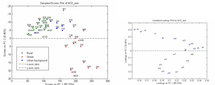
Figure 4C and 4D Scores and loading plots for the first two PCs for diurnal variation of NO2 without autoscaling of the data set.
The results of the analyses performed with diurnal variation without autoscaling confirm that the higher annual NO2 concentration results in a higher PC-1 score. The loadings plot, 4D, shows that the NO2 concentration in the morning is higher than that during the night (the morning hours have a higher loading on PC-1). To check the interpretations of the PCA analyses, we should look closely at Figure 4E, which shows the diurnal pattern in NO2 concentrations for a number of interesting stations. The station with the highest average diurnal pattern is 741 in Nijmegen, a result which is consistent with its highest score on PC-1. When station 411 (Rotterdam) is compared with station 236 (Eindhoven), the former has a higher annual NO2 concentration during the night, while that for the street in Eindhoven is higher in the afternoon, which again is consistent with the scores on PC-2.
In plot 4C, again all stations in the Rotterdam area fall within the upper right quadrant, indicating a typical day–night pattern in this area, as can also be seen for a number of other stations in plot 4F. A comparison of the Rotterdam stations reveals that 448 > 433 > 418 in order of decreasing measured NO2 concentrations, which is consistent with their scores on PC-1.
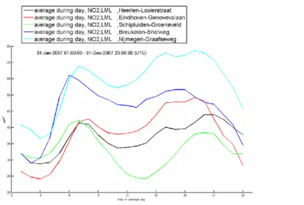
Figure 4E Diurnal variation of NO2 at a number of typical stations.
black: 136 (Heerlen–Looierstraat), green: 411 (Schipluiden), blue: 641 (Breukelen–snelweg), red: 236 (Eindhoven–Genovevalaan),blue: 741 (Nijmegen–Graafseweg)
Figure 4F Diurnal variation of NO2 at stations in the Rotterdam area
Reduction approach using concentration roses: PCA results obtained with and without autoscaling of the data set
The second approach used to combine the 8760 hourly values is obtained by averaging the hourly values over the prevailing wind direction.
Figure 5A and 5B Scores and loadings plot for the first two PCs for average NO2 concentration roses with autoscaling of the data set.
Figure 5C and 5D Scores and loadings plot for the first two PCs for average NO2 concentration roses without autoscaling of the data set.
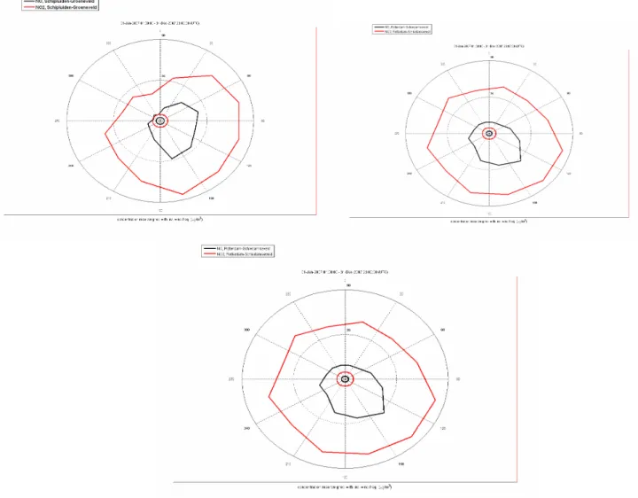
The scores plot obtained with the data set without autoscaling (Figure 5C) again shows the high NO2 concentrations on the right-hand site and the low concentrations on the left. . In general it can be interpreted form the loadings that In NO2 concentrations with south-easterly wind directions (120, 150 and 180) are relatively high and those with north-westerly directions (270, 300, 330, 360 and 30) are relatively low. An examination of the position of station 411 on both PCs emphasizes this phenomenon. From the loadings plot (Figure 5D), it can be seen that the NO2 concentration at this station is high when the wind is south-easterly, as can be confirmed by the concentration rose in Figure 6. This station is clearly influenced by inland activities in the Rotterdam area.
Results of the PCA analysis of NO2
Two PCA analyses of NO2 were performed: in one, we use hourly data and diurnal variation and in the other, concentration roses. Two analyses were also performed for each of these data sets: without and with autoscaling of the data. The results of these analyses show that:
- Autoscaling of the data does not improve the results of the PCA analysis. The plot obtained with the original data shows more variations than that obtained with autoscaled data. - Comparable results were obtained with hourly data and average concentration roses.
The results obtained with the diurnal variation are very comparable to those obtained with hourly data, with one minor exception: in the former analysis, the distinction between stations 641 and 741 is less clear while station 445 is even more distinct.
Strategy for PCA analysis of other components
Based on the results obtained here with NO2, screening for the remaining components examined in this review (NO, PM10, CO, O3, NH3 and SO2) is based on diurnal variation without autoscaling. A major advantage to using diurnal variation over hourly data is the conveniently arranged loadings plot of this analysis, which provides additional information that can be useful. To ensure that all relevant
information is shown, the score plot of the PC-3 is also shown.
Because SO2 is a pollutant with a typical concentration pattern (comprising many peaks), this component is studied using both diurnal variation and average concentration roses.
In addition to the analyses performed with individual components, as described in the Method section, we also analysed traffic (concatenated matrix of NO and NO2 and concatenated matrix of NO and NO2 and CO concentrations). Because the concentration of CO is not at the same magnitude as that of the other substances, CO concentration was divided by 10 before it was combined with the NO and NO2 concentrations.
4.2.2 NO
Diurnal variationFigure 7A and 7B Scores and loadings plots for the first two PCs for diurnal variation of NO. This analysis also shows distinct clusters of stations. The results are in line with the results obtained with NO2.
Figure 7C and 7D: Scores and loadings plot for the third PC for diurnal variation of NO, showing a clear difference for station 641 which is less pronounced in the first two PCs.
Figure 7A confirms important observations from the NO analysis. Urban background station 938 in Groningen shows NO concentrations similar to those of rural stations, and rural station 411 in the Rotterdam area shows NO concentrations similar to those of most urban background stations. The difference between street stations and background stations is more pronounced. Station 641 is very different on PC-3.
Assessment of the loadings plot of PC-3 (Figure 7D) leads to the interpretation that there is a relatively high concentration of NO at station 641 between 05.00 and 06.00 hours (the peak hour on a highway is earlier than that on a normal street), as can be confirmed by Figure 7E.
4.2.3 PM
10Diurnal variation
Figure 8A and 8B Scores and loadings plots for the first two PCs for diurnal variation of PM10 (Note: data coverage at station 520 in 2007 is less than 50%, and station 445 has been non-operational since July 2007).
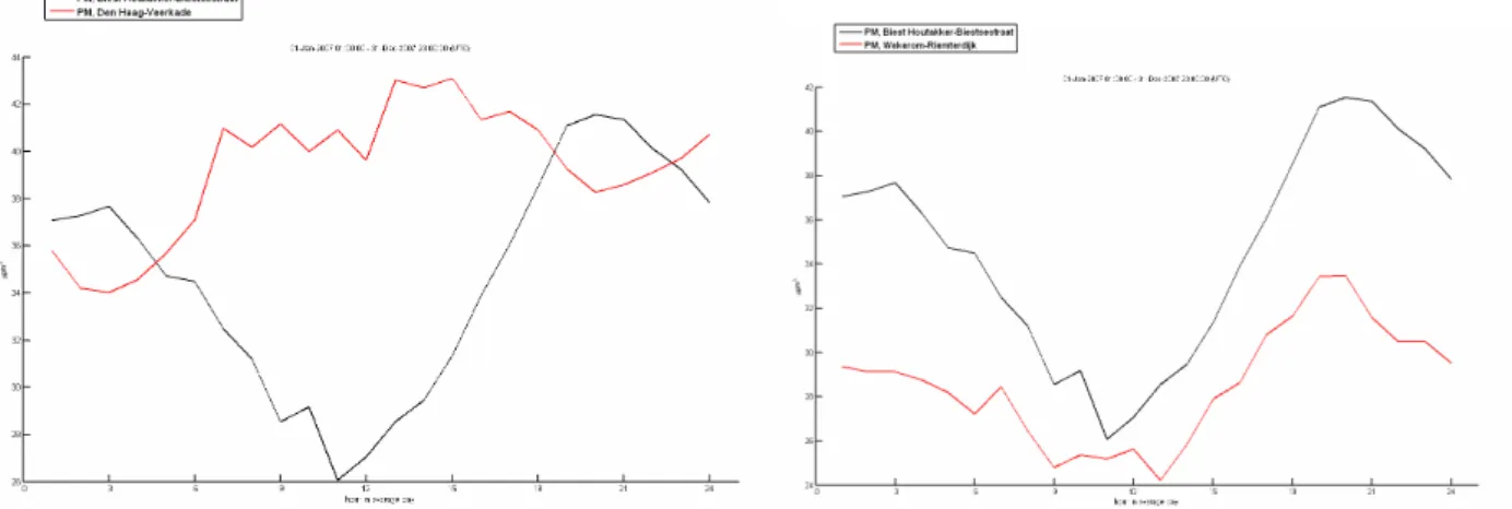
This analysis does not show distinct clusters of street and urban background stations, which is in line with the fact that traffic has only a very limited effect on PM10 concentration. Stations with a high annual concentration have a higher PC-1 score. The loadings plot shows that stations with a high PC-2 score (e.g. station 445) have a high concentration of PM10 during the middle of the day (10–15 hours), while stations with a low PC-2 score (e.g. station 230) have a high PM10 concentration during the night (20–24 hours) and in the early morning (02–06 hours), as can be confirmed by the diurnal variation plot of these two stations (Figure 8C).
Figure 8C Diurnal variation in PM10 at stations Biest Figure 8D Diurnal variation in PM10 at Biest
(230, black) and Den Haag–Veerkade (445, red). (230, black) and Wekerom (738, red).
The most remarkable observations are:
- Station 545 (Amsterdam–A10) resembles a rural station. This observation can be explained by the fact that this station is located on a highway rather than in a normal street and that part of the PM increment found at a normal street station (e.g. PM emission due to fireworks, open fires etc.) is not present along a highway.
- Station 230 (Biest Houtakker–Biestsestraat) is clearly different from other rural stations (Figure 8A).The loadings plot shows that the PM10 concentration at this station is high during the night, as can be confirmed by the diurnal plot in Figure 8D. This profile is consistent with the presence of local sources; due to the stable atmosphere during the night, the pollutants can not be dispersed, resulting in a concentration peak at night.
Street station 445 (Den Haag–Veerkade) is distinct from other stations, but this station has not been in operation since July 2007.
Figure 8E: Scores plot for the third PC.
4.2.4 CO
Diurnal variationFigure 9A and 9B Scores and loading plots for the first two PCs for diurnal variation of CO. (Note: data coverage of CO at station 445 in 2007 was less than 50%).
This analysis also shows distinct clusters of stations. Those stations with a high annual CO concentration have a high PC-1 score, while the PC-2 score represents the pattern of diurnal variation. In addition to showing the difference between stations 938 and 641, this analysis also distinguishes station 236 (Eindhoven–Genovevalaan) from the other stations (i.e. it is clearly separate from other stations based on the PC-2). The loadings plot shows that there is a high concentration of CO at this station between 16
and 19 hours. This is confirmed by the diurnal plot (Figure 9C); the amount of traffic in this street is not symmetrical, with significantly more traffic in the afternoon than in the morning.
The loadings plot also shows that, as expected, there is a high concentration of CO at the street stations during the day (between 08 and 18 hours).
The score plot of the third PC (Figure 9D) does not provide any extra information.
Figure 9C Diurnal variation at stations Figure 9D Scores plot for the third PC. 236 (Eindhoven–Genovevalaan) (black)
and station 237 (Eindhoven–Noordbrabantlaan) (red).
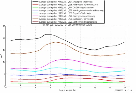
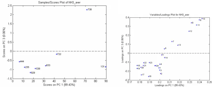
4.2.5 NH
3Stations with high annual concentrations of NH3 have high PC-1 scores. The two extreme stations (131, Vredepeel and 738, Wekerom) are located in areas with high NH3 emissions (intensive agriculture). The difference between diurnal variation patterns is given by PC-2. An analysis of the loadings plot reveals that there is a high concentration of NH3 at station 131 during the night, while there are high NH3 concentrations at stations 722, 235 and 929 during the day, as can be confirmed by Figure 10C. The concentration profile of stations 131(Vredepeel) and 738 (Wekerom) are typical of locations with hot spots. The more stable atmosphere during the night results in a reduced dispersion of pollutants and, consequently, a higher NH3 concentration.
Figure 10C Diurnal variation of NH3 at the monitoring stations.
The distinctive position of station 738 is shown more clearly on the score plot of the third PC
(Figure 10D). From the loadings plot of this PC it can be interpreted that the NH3 concentration at this station is relatively high in the morning (08–10 hours), while at other stations, the NH3 concentration is relatively high in the afternoon (16–17 hours).
Figure 10D and 10E Scores and loadings plots for the third PC for diurnal variation of NH3 .
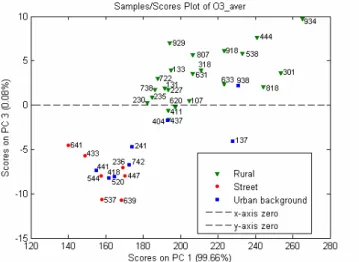
4.2.6 O
3Diurnal variation
Figure 11A and 11B Scores and loading plots for the first two PCs for diurnal variation of O3. For O3, stations 441, 520, 938, 411 and 133 are classified as suburban.
measured at rural station 133. In Figure 11A, station 137 is above and to the right of rural station 133, while station 938 is under and to the left of rural station 934. The scores plot of the third PC (Figure 11D) also shows that station 137 is different, and Figure 11C shows that the station 137 has a different diurnal variation. We currently cannot explain this difference, and it is unclear as to whether it is caused by the building near this station 137 because such a difference is not observed with the other
components.
The loadings plot shows that stations with a negative PC-2 score have peak O3 concentrations in the afternoon (14–18 hours). These stations are located in the south-eastern part of the Netherlands. Compared to station 133 (south-east Netherlands), station 934 (located in the northern part of the Netherlands) has a higher average O3 concentration, but station 133 has more peak concentrations.
Figure 11C Diurnal variation of O3 at Figure 11D Scores plot for the third PC of O3. station 934 (Kollumerwaard, rural) (green),
station 133 (Wijnandsrade, rural) (black), station 137(Heerlen, urban background) (red), station 938 (Groningen, urban background) (blue).
Stations 938 (Groningen), 441 (Dordrecht–Frisostraat) and 520 (Amsterdam–Florapark) are currently classified as suburban. Suburban stations are important because it is precisely in the suburbs of major cities that many inhabitants can be exposed to O3concentrations that are higher than those found in city centres. High O3concentrations, comparable to those measured at rural locations, were found at the station in Groningen (938). Stations 441 and 520 are classified as suburban because both of these measurement stations are located some distance from the centre of the city/agglomeration. The PCA analysis (Figure 11A) shows that these stations are not very different from those of other urban background stations. Based on the PCA analysis, station 404 (Den Haag) would seem to be an appropriate station to monitor suburban concentrations.
4.2.7 SO
2Diurnal variation
Figure 12A and 12B Scores and loadings plots of the first two PCs for diurnal variation of SO2.
There are no distinct clusters of urban background and street stations, which is in line with the fact that SO2 is not a traffic-related pollutant. A number of stations lie outside the group: 433 (Vlaardingen– Floreslaan), 416 (Vlaardingen–Lyceumlaan) and 448 (Rotterdam–Bentinckplein).
The loadings plot (Figure 12B) shows that there are high concentrations of SO2 in the early morning at stations with a positive PC-2 score (stations 416 and 433), while high concentrations at other stations occur during the day (12–18 hours). This distribution is confirmed by the diurnal plot in Figure 12C.
Average concentration roses
Figure 12E and 12F Scores and loadings plots of the first two PCs for average concentration roses of SO2.
The upper left quadrant of the scores plot shows those stations in the southern part of the Netherlands; those stations around Rotterdam are shown in the bottom right quadrant. The loadings plot shows that the concentration of SO2 at, for example, stations 107, 133 and 136 is high when the wind is north-easterly, while there is a high SO2 concentration at station 416 when the wind is from the south, as can be confirmed by the wind roses in Figure 12G and 12H. High concentrations of SO2 are found for the stations around Rotterdam; these are attributed to the contribution from Pernis and the Rotterdam harbour.
Figure 12G Average concentration roses at Figure 12H Average concentration roses
Figure 12I Scores and loadings plots for the third PC for average concentration roses of SO2. The distinctiveness of stations 318 and 448 is shown more clearly by the third PC.
4.3 Analysis performed with data from an earlier year (1994)
No major observable change has occurred between 1994 and 2007 in terms of measurable NO
concentrations (Figure 7Aand B). Station 641 is also distinct from other street stations in the 1994 data set (shown more clearly by the third PC). The pattern of the loadings plot for 1994 is comparable to that for 2007.
Figure 13C Scores plot for the third PC. The distinctiveness of station 641 (which is located on a highway) is also shown clearly here by the third PC.
4.3.2
NO
2Figure 14A and 14B Scores and loadings plots for the first two PCs for diurnal variation of NO2 in 1994.
In terms of NO2, the 1994 results shown in Figure 14A and 14B are comparable to those for 2007 (Figure 4A and B). Both loadings plots have comparable patterns. As in 2007, in 1994 the urban background station 418 (Rotterdam–Schiedamsevest) resemble a street station in terms of NO2 concentration.
Figure 14C Scores and loadings plots for the third PC for diurnal variation of NO2 in 1994. No additional information was obtained.
4.3.3 PM
10Figure 15A and 15B Scores and loadings plots for the first two PCs for diurnal variation of PM10 in 1994.
Figure 15C Scores plot for the third PC for diurnal variation of PM10. No extra information is shown.
4.3.4 CO
Figure 16A and 16B Scores and loadings plots for the first two PCs for diurnal variation of CO in 1994.
As in 2007, the scores and loadings plots for 1994 also show distinct clusters of stations. The CO monitoring network has undergone major changes in the 15 years between 1994 and 2007, primarily in terms of the removal of a large number of street stations from the network and the addition of many new stations to it. For those stations which were already operational in 1994, there is no major difference between the situation then and the current situation in terms of CO levels. The loadings plot for 1994 has more or less a comparable pattern to that for 2007.
Figure 16C Scores and loadings plots for the third PC for diurnal variation of CO in 1994.
4.3.5 NH
3Figure 17A and 17B Scores and loadings plots for the first two PCs for diurnal variation of NH3 in 1994.
Figure 17C Scores plot for the third PC for diurnal variation of NH3 in 1994.
4.3.6 O
3Figure 18A and 18B Scores and loadings plots for the first two PCs for diurnal variation of O3 in 1994.
No major change is observed between the analysis for O3 in 1994 and that in 2007 (Figure 11A and B). As in 2007, in 1997, the rural stations form a distinct cluster (with higher annual concentration and high PC-1 scores), while the urban background and street stations are mixed. The pattern of the loadings plot for 1994 is also comparable to that for 2007.
Figure 18C Scores plot for the third PC for diurnal variation of O3 in 1994.
4.3.7 SO
2Figure 19A and 19B Scores and loadings plots for the first two PCs for diurnal variation of SO2 in 1994.
In both 1994 and 2007, two stations, namely, 433 and 416, are distinct from the other stations. Compared to 2007 (Figure 12A and B), however, in the 1994 plots these two stations are less distinct
Figure 19C Scores plot for the third PC for diurnal variation of SO2 in 1994. In this plot also, the distinction of the stations 416 and 433 is clear.
4.4 Pollutants from traffic
4.4.1 Combination of NO and NO
2Diurnal variation
Figure 20A and 20B Scores and loadings plots for the first two PCs obtained with the diurnal variation of the combination NO and NO2.
Distinct clusters of stations are shown, with the most distinct being stations 938, 641, 411 and, to a less extent, stations 741 and 418. Our general conclusion is that this analysis accurately portrays the information obtained by the analysis of each of these two components individually. Two observations based on the combination analysis are that average concentrations are higher for NO2, and that the difference between traffic and background locations is greater for NO.
Figure 20C Scores plot for the third PC obtained with the diurnal variation of the combination NO and NO2. No new information is obtained with this plot.
4.4.2 Combination of NO, NO
2and CO
Distinct clusters of stations are shown, with the most distinct being stations 938, 411, 641, 741 and 445, as already observed in the analyses of these components separately. Station 641 is located on a highway and clearly differs from other street stations. The observed distinctiveness of stations 445 and 741 can be explained by the different locations of these stations: station 445 is located in the middle of the street and station 741 is located nearby a traffic circle.
The ratio between CO and NO emissions is dependent on the age of the vehicles. The cars making up the traffic around stations 641, 544, 448 and 537 are more modern than those around stations 636, 639, 237, 236 and 136. In the PCA analysis, station 641 (highway) is clearly different, but the other stations do not show a systematic difference in terms of pattern.
Because the loadings plot is dominated by station 641, the same plots are shown in Figure 21C and D for the data set without station 641. The loadings plot 21D shows that there is relatively more NO and more CO at street stations (except during the night) than at the background stations. The loadings plot in Figure 21D also shows a correlation between NO and NO2, as expected.
Figure 21E Scores plot for the third PC obtained with the diurnal variation of the combination NO and NO2 And CO. This plot does not show any extra information.
4.5 Agriculture-related pollutant (NH
3)
This study does not reveal any irregularities at the NH3 monitoring stations. Compared to 1994, the NH3 concentration in 2007 is approximately 30% lower. In addition, at locations with intensive agriculture (131, Vredepeel; 738, Wekerom), NH3 emissions are currently much more dispersed than in the past (Appendix 7). This change occurred around 2002, as can be seen in Appendix 7, which shows the diurnal variation of NH3 at Vredepeel over the period 1994–2007. The average concentration roses at stations 131 and 738 (Appendix 8) show that the source of station 131 is located to the north-east of this station and that the source of station 738 is located to the north-west of this station.
The diurnal variation at station 633 (Zegveld) has also changed since 1994. This change took place around 2001, and since that year the concentration has decreased during the night, resulting in a small peak in the morning. The diurnal variation at this station over the period 1994–2007 is shown in Appendix 7.
Despite the overgrowth around station 722 (Eibergen) neither the PCA analyses nor the diurnal variation plots reveal any noticeable trends in the concentration measured at this station. This is illustrated in Appendix 7, which shows the diurnal variation at this station over the last 7 years.
such as wind roses analyses, photographs, among others. An overview of these observations is given in Table 1.
Table 1: Overview of PCA screening results.
Station Nr. Type Remarkable observation Observed with components
Possible cause of observed distinction
938 (Groningen–Nijensteinheerd) UB More like a rural station
NO,NO2,CO,
PM,O3
Located in the suburb of Groningen 411 (Schipluiden–Groenveld) R More like an urban
background station
NO,NO2 Contribution of inland activities
418 (Rotterdam–Schiedamsevest) UB More like a street station
NO2 Contribution of the Rotterdam harbour
445 (Den Haag-Veerkade) S Distinct from other street stations
NO2 Located in the middle of the street (has been
replaced in 2009) 520 (Amsterdam–Florapark) UB Distinct from other
UB stations
NO2 Influenced by the traffic from the IJ-tunnel
641 (Breukelen-Snelweg) S Distinct from other street stations
NO,NO2,CO Located on a high way
741 (Nijmegen–Graafseweg) S Distinct from other street stations
NO,NO2,CO Located nearby (±100 m) a traffic circle.
The distance to the traffic circle is,
however, larger than the restriction of 25 m 230 (Biest Houtakker–
Biestsestraat)
R Distinct from other rural stations
PM Diurnal variation shows hotspots of PM 545 (Amsterdam–A10 west) S More like a rural
station
PM Located on a highway (Amsterdam A10) 416 (Vlaardingen–Lyceumlaan) UB Distinct from other
stations
SO2 Contribution from Pernis/Rotterdam
harbour 433 (Vlaardingen–Floreslaan) S Distinct from other
stations
SO2 Contribution from Pernis/Rotterdam
harbour 448 (Rotterdam–Bentinckplein) S Distinct from other
street stations
SO2 Contribution from Pernis/Rotterdam
harbour 131(Vredepeel),
738 (Wekerom)
R Distinct from other stations
NH3 Diurnal variation shows hotspots of NH3
441 (Dordrecht–Frisostraat), 520 (Amsterdam–Florapark) Suburb (*) More like UB O3 137 (Heerlen– Nicolayestraat)
UB Differs from other UB stations
O3 Not clear yet
Notes (*): only for O3. For other components, these stations are UB stations Abbreviations: R: Rural; UB: Urban background; S: Street
This study shows that, in general, the monitoring stations of the LML represent the current classification well and that the character of the stations has not been changed markedly over the study period. No irregularity was observed for NH3 (all at rural stations). The overgrowth around station 722 (Eibergen) does not result in noticeable trends in the NH3 concentration measured at this station, and the pruning of trees in the spring and autumn of 2008 also did not have an effect on the NH3 concentration profiles of station 722 in comparison with those of other rural stations (see chapter 5).
This study reveals that for some of the measurement stations, some interpretations of the data may not be consistent with the current classification. These stations are:
• Two street stations (641, 545) that are located on a highway; these clearly differ from other street stations.
• Station 938, which is located in a suburb of Groningen and classified as an urban background station (suburb for O3). The PCA performed in this study shows that this station has the character of a rural station.
• Although stations 441 (Dordrecht–Frisostraat) and 520 (Amsterdam–Florapark) are currently classified as suburb stations for O3, the PCA analysis performed here shows that these stations do not differ from other urban background stations. In AIRBASE, these stations are also classified as urban background also for O3.
5 Influence of vegetation (trees and shrubs)
Vegetation has different effects on the measurement of pollutants. In some cases, the representativeness of a monitoring station can be negatively affected by the presence of vegetation around it; however, these effects are complex and depend on the components of interest:
• Trees can hamper the unrestricted air flow around inlet points, but it is not easy to estimate the impact of trees based on the number of trees around a monitoring station
• If the percentage of tree cover is large enough, the presence of vegetation may reduce the air temperature and the quantity of HV-light around the monitoring station. Consequently, O3 formation, which occurs via the reaction NO2+HV+O2→NO+O3 , is reduced
• Some tree species can also emit volatile organic compounds (VOCs) that contribute to the formation of O3. If this occurs around an urban/rural station, the measurement at that station may not be representative of the air quality of the larger area. Poplar, oak and willow are only some of the tree genera that have the highest standardized isoprene emission rate (Nowak, 1999)
In principle, a tree can remove air pollutants through absorption of the gaseous pollutant (NO2, O3, SO2) in the water film inside the leaf or by adsorption on the plant surface (PM). However, the effect is generally limited. The RIVM (Wesseling et al., 2008) has studied the effect of vegetation on the concentrations of PM10 in and around cities. The conclusion of this study was: ‘The presence of
vegetation can either increase or decrease the concentrations of ambient PM10.Vegetation growing along a road or planted in the median (islands) has the effect of lowering the average wind speed, possibly resulting in increasing local concentrations of PM10 (negative effect).Conversely, the presence of vegetation may filter out the (larger) particles, thereby lowering PM10 concentrations (positive effect). The net effect of these processes on air quality is, however, generally limited’. The adsorption effect of leaves on the NO2 levels is also negligible.
There are two stations in the LML where measurements may have been influenced by the presence of trees: station 722 (Eibergen) and 520 (Amsterdam–Florapark).
Station 722 (Eibergen), rural station
This monitoring station is a rural background station and is located on an area with a lot of vegetation. There were a number of large trees in the close proximity of the station that had not been pruned for many years. Despite the presence of these trees, however, the PCA analysis (chapter 4) and the diurnal variation of NH3 at this station during the last 7 year does not reveal any effect of this overgrowth. To ensure a good measurement at this station, some maintenance work was carried out in 2008
(Figures 22A–C):
• In the spring of 2008 (between 18 March and 15 April; exact date is unknown), the twigs and the trees which leaned against the inlet of the station were removed
• In the autumn of 2008 (exact date is not known), a second maintenance was carried out, and a number of trees around this station were removed
Figures 22A (upper): Photograph made on 18 March 2008, before the first pruning
22B (middle): Photograph made on 15t April 2008: some twigs and trees were removed 22C (bottom): Photograph made on 3 March 2009: more trees were removed
The effect of pruning on the concentration of NH3 at the Eibergen station is shown in Figure 23 as average monthly concentrations of NH3 and O3 before and after the pruning took place: January– February 2008, before the first pruning; May 2008, after the first pruning; December 2008–June 2009, period after the second pruning
When the concentrations measured at other monitoring stations are compared to those at the Eibergen station, it is clear that pruning has had no observable effect on the measurement of NH3. We can therefore assume that the possible effect of vegetation on the monitoring results of NH3 and O3 is negligible at Eibergen. 0 5 10 15 20 25 Ja n 20 08 F eb 20 08 May 20 08 D ec 20 08 March 20 09 Ju n 20 09 NH 3 ,μ g/ m 3 10 20 30 40 50 60 70 80 Ja n 20 08 F eb 20 08 M ay 20 08 D ec 20 08 March 20 09 Ju n 20 09 O3, μ gm 3 131 235 444 538 633 722 738 929
Figure 23 Average monthly concentration of NH3 (left) and O3 (right) at Eibergen (station 722) before and after the two prunings.
Station 520 (Amsterdam–Florapark), urban background station
This station is located on an area with large mound of vegetation. A portion of the vegetation was removed on 3 and 4 December 2007 during maintenance work at this location. The NO2 concentrations at this station and at station 544 (Amsterdam–Prins Bernhardplein) in this period are shown in
Figure 24. This figure does not show any change in the concentration of NO2 measured at this station after the maintenance.
0 10 20 30 40 50 60 70 80 90 02 D ec 03 D ec 04 D ec 05 D ec 06 D ec 07 D ec NO 2 ,μ g / m 3 520 544
Figure 24 Concentration of NO2 at Amsterdam–Florapark (station 520) before and after the pruning. There is no O3 measurement for this period.
6 Discussion
6.1 Classification
Compared to the AIRBASE classification, the Dutch classification is a simple one in which stations are divided into three classes – rural (R), urban background (UB) and street (S), with an extra classification ‘suburban’ for O3. The AIRBASE classification has three zone classes – rural, urban and suburban – and three station types – background, traffic and industrial. The PCA analysis performed in this study shows that, for a number of stations in the LML, the more detailed AIRBASE classification is more
representative. For example, station 938 (UB), which is located in a suburb of Groningen, has the class ‘suburban background’ in AIRBASE; station 411(R) has also the class ‘suburban background’ in AIRBASE; station 641 (street), which is located on a highway, has the classification ‘traffic rural’ in AIRBASE. This classification aspect is relevant and should be taken into account when the
measurement data are validated; for example, the measurement data of station 938 should be compared with caution to the concentrations measured at another urban background station.
Another confounding factor is that even a sophisticated classification can never fully describe the character of a measurement station because this character depends on the component of interest. For example, ‘rural’ station 131 (Vredepeel) is clearly influenced by the local NH3 hotspot, and ‘rural’ station 231 (Biest) may be influenced by PM hotspots. However, in terms of other components, these stations have indeed the character of a ‘rural’ station. Likewise, the stations in the Rotterdam area are influenced by SO2 hotspots. A detailed knowledge of these characteristics is relevant for modelling purposes and for data validation. An overview of these characteristics is given in chapter 7. For street stations, a more detailed description of the street and the effect of their geometry on the CAR results can be found in the RIVM report on the CAR model (Wesseling et al., 2007).
6.2 Representativeness
In practice it is not easy to investigate whether a station is representative or not. The criteria on macro and micro sitings listed in Annex III of the Directive are only global guidelines. These guidelines do not provide answers to the following specific questions:
• Does the building nearby the station 137 influence the representativeness of this station? • Does the presence of the vegetation around stations 722 and 520 influence the
representativeness of these stations?
It is not evident that these stations are not representative because of the above factors (see chapters 4 and 5). On the other hand, it is also possible that these factors have some effect on the measurements that is not revealed by the data analysis because of other processes. Therefore, rigorous changes at these stations are not necessary, although regular pruning is recommended. Recent pruning did not show a noticeable effect on the measured concentrations. While it is not necessary to replace station 137 immediately, when this station has to be renewed, the new monitoring station should preferably be
7 Conclusions
The evaluation of the LML has resulted in several observations, and an overview of these is given in table 2. Some of these observations are only informative in nature. However, the evaluation has also identified a number of issues that require more attention. These issues concern good housekeeping practices, the location of the monitoring station (site 137), the classification of the monitoring station (4 sites) and the documentation of the LML.
The following is recommended:
• Good housekeeping: trees growing in close proximity to monitoring stations have to be pruned regularly to prevent obstruction of the inlet.
• The vegetation around stations 722 and 520 must be pruned regularly; in fact, adequate measures have already been taken.
• The location of site 137 may not be optimal for the measurement of urban background concentrations because this station is located very close to a building, and a representative sampling of air from a large area can not be guaranteed. Because the data analysis has not proven that the current location affects the representativeness of this station, it is not necessary to replace this station immediately. However, when this station is renewed, the new monitoring station should preferably be placed at a more suitable site in this area.
• Classification: compared to the AIRBASE classification, the Dutch classification is a simple one. The PCA analysis shows that the more detailed AIRBASE classification is more
representative for a number of stations in the LML. This aspect is very relevant and should be taken into account when the data of the measurements are interpreted.
- Street station 641 (Breukelen–snelweg) is located on a highway and differs clearly from other street stations. This difference is reflected in airborne background concentrations. The classification Rural Traffic is more representative.
- Street station 545 (Amsterdam–A10 west) is located on a highway and differs clearly from other street stations.
- Station 938 (Groningen–Nijensteinheerd) is classified as an urban background (UB) station (suburb for O3), but it would be better classified as a rural/suburb station. - Stations 441(Dordrecht–Frisostraat) and 520 (Amsterdam–Florapark) are currently
classified as suburb stations for O3. In AIRBASE, these stations are classified as urban background, also for O3. The evaluation shows that this classification is more
representative.
• Completion of the documentation: three sites – 441(Dordrecht–Frisostraat, UB station), 446 (Den Haag–Bleriotlaan, UB station) and 447 (Leiden–Willem de Zwijgerlaan, Street station) – are currently not shown in the Google Maps application. Completion of this application with omitted sites is necessary.