Accessibility Analysis
and Transport
Planning
Challenges for Europe and North America
Edited by
Karst T. Geurs
University of Twente, the Netherlands
Kevin J. Krizek
University of Colorado, Boulder, USA
Aura Reggiani
University of Bologna, Italy
NECTAR SERIES ON TRANSPORTATION AND COMMUNICATIONS NETWORKS RESEARCH
Edward Elgar
All rights reserved. No part of this publication may be reproduced, stored in a retrieval system or transmitted in any form or by any means, electronic, mechanical or photocopying, recording, or otherwise without the prior permission of the publisher.
Published by
Edward Elgar Publishing Limited The Lypiatts
15 Lansdown Road Cheltenham Glos GL50 2JA UK
Edward Elgar Publishing, Inc. William Pratt House
9 Dewey Court Northampton Massachusetts 01060 USA
A catalogue record for this book is available from the British Library
Library of Congress Control Number: 2012938072
ISBN 978 1 78100 010 6
Typeset by Servis Filmsetting Ltd, Stockport, Cheshire Printed and bound by MPG Books Group, UK
land use and public transport policy
plans in the Netherlands
Karst T. Geurs, Michiel de Bok and
Barry Zondag
8.1 INTRODUCTION
Major investments in public transport in the Netherlands are often considered ineffi cient from a welfare economic perspective. Bakker and Zwaneveld (2010) show that of about 150 social cost–benefi t analyses (CBAs) of public transport projects in the Netherlands conducted in the past decades, only one- third of the projects had a positive benefi t–cost ratio. These public transport projects were typically not part of an inte-grated planning approach, and the CBAs examined the costs and benefi ts of the transport projects only. In particular, the role of spatial planning or spatial developments in these CBAs was ignored or not made explicit (that is, land use is assumed to be fi xed or does not diff er between project alternatives). In recent years, however, integrated spatial and transport planning has received more attention in Dutch national policy- making. In 2007, a national policy document, Randstad Urgent, was published, aiming to improve cooperation between national and regional governments and create a joint policy decision- making process for diff erent spatial projects and transport infrastructure projects that are to be realized within the same region (Ministry of Transport Public Works and Water Management, 2007). The policy document focused on 40 projects within the Randstad Area, the most urbanized region in the western part of the Netherlands. The aim of this new approach is to speed up the decision- making process and increase the social benefi t–cost ratio of the projects. In this chapter, we examine the RAAM project (‘Rijksbesluiten Amsterdam – Almere – Markermeer’), the largest integrated policy project included in Randstad
Urgent. The project involves adding 60 000 dwellings and 100 000 jobs
and major transport investments in the corridor between Amsterdam Airport Schiphol, Amsterdam and Almere, located 30 kilometres east of
Amsterdam (see Figure 8.1). Almere would nearly double in size from its current 190 000 to 350 000 inhabitants by 2030. Local governments devel-oped three spatial policy alternatives for the development of Almere with tailored public transport investment programmes. Almere is a new town built on reclaimed land (a polder) with two bridges linking two motorways (A6 and A27) and a railway (parallel to the A6) linking to the mainland. These road connections are already severely congested and rail capacity is insuffi cient to increase train frequencies substantially. Doubling the popu-lation of Almere is not considered feasible without major infrastructure expansion. Transport investments are thus seen of crucial importance to the future population growth of Almere.
As part of the decision- making process, a CBA was conducted examin-ing the social costs and benefi ts of (combinations of) three land- use alter-natives and six rail project alteralter-natives (Zwaneveld et al., 2009). A national system of road pricing was also examined. In the CBA, a stand- alone regional transport model was applied – as prescribed by Dutch appraisal guidelines – to estimate transport demand and travel time changes as input for the conventional rule- of- half measure of accessibility benefi ts.
The aim of this chapter is to examine whether spatial planning can have a positive impact on the accessibility benefi ts of integrated spatial and public transport projects. Two methodological issues were explored,
Figure 8.1 Main alternatives for improving the rail link between Amsterdam and Almere
in addition to the current practice, to study these impacts. Firstly, a national land- use and transport interaction model, called Tigris XL, was used instead of a stand- alone transport model. Secondly, accessibility benefi ts were calculated following the logsum measures, in addition to the standard rule- of- half calculation method.
The Tigris XL model was fi rst used to validate population and employ-ment projections for Almere and the surrounding region under the pro-posed growth scenario. The combination of land- use plans and supportive public transport investment plans creates a typical planning issue which can best be evaluated with an integrated land- use and transport interac-tion model (LUTI). These models are praised for their ability to evaluate land- use and transport planning in an integrated and consistent modelling system (e.g., see Simmonds, 2004; Waddell et al., 2007); however, there are few applications of empirically estimated LUTI models.
The logsum accessibility measure seems to be getting more attention in academic research (e.g., see De Jong et al., 2007; Geurs et al., 2010), but is seldom applied in practical appraisal studies. Applying the logsum method requires a disaggregated type of transport model. The Tigris XL model includes the disaggregated National Transport Model (LMS) as transport model of the Netherlands, and was used in an earlier study to estimate accessibility benefi ts of land- use and transport policy strategies using the logsum accessibility measure (Geurs et al., 2010). Computing the logsum measure using the Tigris XL framework allows an estimation of the acces-sibility benefi ts of the diff erent land- use policy alternatives proposed for the expansion of Almere, as compared to a reference land- use scenario.
Section 8.2 describes the modelling framework and how accessibility eff ects are calculated. Section 8.3 describes the land- use policy planning scenarios for Almere. Sections 8.4 and 8.5 present the model results for the diff erent scenarios based on population and employment developments and accessibility impacts. Section 8.6 examines whether there are synergies in accessibility benefi ts between the land- use policy alternatives and rail invest-ments. Finally, section 8.7 discusses the results and presents conclusions.
8.2 METHODOLOGY
Brief Description of Land- Use–Transport Interaction Model Tigris XL
Land- use and transport policies both aff ect accessibility for fi rms and resi-dents. A land- use and transport interaction model is capable of calculat-ing accessibility changes resultcalculat-ing from land- use and transport strategies. This includes the mutual interactions between land use and transport over
time, the outcome of which is diff erent than the sum of the two measures evaluated individually. In this study, changes in accessibility are calcu-lated by the Tigris XL model, an integrated land- use and transport model developed for the Transport Research Centre in the Netherlands (RAND Europe, 2006; Zondag, 2007).
The Tigris XL model is a system of submodels (or modules) that includes dynamic interactions between the models. The modelling system consists of modules addressing specifi c markets. Its land- use model comprises the land market, housing market, commercial real- estate market and labour market. These modules are applied with time steps of one year, which enables the user to analyse how land use evolves over time. The land- use model is fully integrated with the National Transport Model (LMS) of the Netherlands, and both the land- use and the transport model interact every fi ve years. Tigris XL operates at the spatial resolution of local transport zones (1327 zones, covering the Netherlands).
Core modules in Tigris XL are the housing- market and labour- market modules. These modules include the eff ect of changes in the transport system on residential or fi rm location behaviour, and in this way link changes in the transport system to changes in land use. The parameters for both modules have been statistically estimated. The residential location choice module has been estimated by household type on a large housing market survey conducted once every four years in the Netherlands with over 100 000 households participating. The parameters of the fi rm (simu-lated as jobs) location choice module have been estimated on a historical dataset (1986–2000), including employment fi gures by seven economic sectors at a local level.
A land and real- estate module simulates supply constraints arising from the amount of available land, land- use policies and construction. The module can be used for diff erent levels of government infl uence, ranging from complete regulation to free market conditions, and various feedback loops between demand and supply are possible. A demographic module is included to simulate demographic developments at the local level. At the regional or national level, the model output is consistent with existing socio- economic forecasts.
The LMS calculates the changes in transport demand and accessibility. The LMS consists of a set of discrete- choice models for various choices in transport (including tour frequency, transport mode, destination and departure time). These choice models can be based on the microeconomic utility theory, enabling the derivation of utility- based accessibility meas-ures. In this chapter, we focus on the accessibility benefi t measures which can be calculated following the rule- of- half or the logsum method.
The Rule- of- Half Measure of Accessibility Benefi ts
The conventional approach to measuring accessibility benefi ts of trans-port strategies is to use the rule- of- half measure as an approximation of Marshallian consumer surplus. The rule- of- half equation computes the total change in user benefi ts as the sum of the full benefi t obtained by original travellers and half the benefi t obtained by new travellers or gener-ated traffi c. This can be calculated by multiplying the average number of trips between a base scenario (0) and a scenario with a project (1) by the diff erence in (generalized) travel costs:
DE (CSnROH) 5 2 0.5 aZ z 5 1a J j 5 1(GCzj 1 2 GC zj 0) (A zj 1 1 A zj 0) (8.1)
where GC is generalized cost; z is the origin location (z = 1, . . ., Z); j the transport mode/destination alternative (j = 1, . . ., J); and A the number of trips.
It is important to note that the rule- of- half measure of consumer surplus assumes that all accessibility benefi ts accruing to economic agents can be attributed to generalized cost changes within the transport system. The literature points out that the rule- of- half results in incorrectly meas-ured welfare eff ects of land- use policy plans (e.g., Neuburger, 1971) and of transport strategies that lead to land- use changes (Bates, 2006; Geurs et al., 2006; Simmonds, 2004). To capture these benefi ts, a method is needed that not only values the changes in generalized costs, but also values accessibility benefi ts due to changes in location and the relative attractiveness of locations. For a more elaborate discussion, see Geurs et al. (2010).
The Logsum Measure of Accessibility Benefi ts
Here, we briefl y describe the derivation of logsum accessibility benefi ts from Tigris XL. For a more detailed description, see Geurs et al. (2010). See De Jong et al. (2007) for an overview of literature on the logsum approach. The logsums in the Tigris XL model are derived from the LMS. A disaggregate transport model is required to apply the logsum method. It should be noted that this method can also be applied to stand- alone trans-port models of a disaggregated type. Based on the LMS, these logsums are computed for tours (round trips) at the individual level, and express a traveller’s utility from a choice set of travel alternatives. This choice set contains fi ve diff erent transport modes (car driver; car passenger; train; bus, tram or metro; walking or cycling) available to all 1327 possible destinations. The logsum for each origin zone z in the Tigris XL model is
computed from the travel alternatives to all destinations and transport- mode combinations j for each person type i (490 person types segmented to 5 household income classes, 2 gender classes and 49 age classes), and travel purpose p:
Lpiz5 loga a
j
exp (mpVpijz)b (8.2) where Vpijz is deterministic or observed utility for person i in zone z, choosing mode and destination combination j for travel purpose p; mp is the logsum coeffi cient for travel purpose p (this coeffi cient appears here because we are using a nested logit model for each travel purpose). The utility component in the transport mode and destination choice models of the LMS in a simplifi ed form can be specifi ed as:
Vzijp = bpTzj 1 cphln(Czj) 1 dpDpj 1 . . . (8.3) where T is travel time (comprising various components with their own coeffi cients), C the travel cost, and D a variable representing the attractiveness of the destination zone (destination utility) for a spe-cifi c activity (for example population, employment, shopping, number of students at schools and universities). The cost coeffi cients c diff er between travel purposes, but also between income groups h per travel purpose. The cost variable enters in logarithmic form, refl ecting cost damping with increasing travel distances. Standard applications of the rule- of- half include changes in T and C (together forming general-ized travel costs), but not in D from equation (8.3). It is, however, not inconceivable also to include changes in D in the rule- of- half, but this can be done more easily by using logsum changes (Geurs et al., 2010). Note that changes in departure times and route choices are also taken into account in the logsums indirectly through iterations between the transport mode and destination choice models and traffi c assignment models in the LMS.
The logsums are translated into travel times by the time coeffi cients bp, and into costs by external values of time, VoT. The travel time coeffi cients are purpose- specifi c and are estimated for the mode and destination choice model in the LMS. The values of time, VoTph, per travel purpose p and household income category h, in equation 8.4 come from stated preference research, and represent the offi cially recommended values for transport appraisal in the Netherlands. The monetary value of the accessibility of zone z for a person of type i who belongs to household income group h is computed as follows, with bp being in time units:
CSL
piz5 VoTph#
1
bp#Lpiz (8.4)
For accessibility evaluation, the accessibility benefi ts are computed over all actors in the transport model by multiplying the accessibility value by the number of people Apiz in population segment i that make a tour for purpose p from zone z (or, more exactly, the number of tours in this population segment for this purpose from this origin):
DE (CSpiz) 5 (1/an)cA1 pizlna a J1 j 5 1e V1 njb 2 A0 pizlna a J0 j 5 1e V0njb d (8.5)
where the superscript 1 refers to the situation with the policy to be evalu-ated and the superscript 0 to the situation without the policy (reference).
The application of the logsum method has a number of advantages over the rule- of- half measure of accessibility benefi ts. The most important advantage for this chapter is that the logsum is capable of providing the accessibility benefi ts from changes in the spatial distribution of activi-ties, due to transport or land- use policies, where the rule- of- half method ignores the changes in destination utility (see Geurs et al., 2010 for a more detailed discussion). Another advantage of the logsum method is that it uses a more precise non- linear demand curve, while the rule- of- half method assumes a linear demand curve. This is not the most important advantage, however. In theory, when land use is fi xed, an accessibility benefi t approximation based on the rule- of- half will diff er only slightly from the more exact logsum measure when computed at the same level of aggregation (for example, see for a comparison, Bates, 2006).
8.3
INTEGRATED LAND- USE/TRANSPORT
SCENARIOS FOR ALMERE
Reference Scenario
The case study for the growth scenario of Almere consists of a reference scenario and three diff erent spatial development scenarios for the simula-tion period 2010 to 2030. These scenarios are translated to Tigris XL input in the form of housing programme (yearly demolition, reconstruction and greenfi eld development by zones) and industrial site development (offi ce space and industrial sites).
The reference scenario (without the additional land- use and transport projects for the Almere region) incorporates the existing planned housing
developments and national road and rail investments for the period up to 2020. The reference scenario is a business- as- usual scenario in which Almere still is expected to grow, but at a modest level. The reference sce-nario assumes that the number of houses in Almere increases by 30 000 houses in the period 2010–2030, while an increase of 60 000 houses is assumed in all Almere cases. Furthermore, there are already substantial infrastructure investments planned in the Almere region. Planned road investments include motorway capacity increases between Amsterdam and Almere, as well as rail investments allowing a doubling of train fre-quency between Amsterdam and Almere from six to 12 trains per hour. A national road- charging scheme is also assumed to be introduced in 2015 in most project alternatives. The road- charging scheme involves the abolish-ment of existing road taxes and 25 per cent of vehicle purchase taxes and the introduction of a kilometre charge, consisting of usage- based charge (4 eurocents per kilometre) and a congestion charge on the main motor-way network. This kilometre charge was part of Dutch national transport policy at the time the CBA was conducted, but has been subsequently dropped by the cabinet which took offi ce in October 2010.
Almere Growth Scenarios
Three alternative land- use scenarios were developed by the municipal-ity of Almere, each containing a dedicated supportive public transport investment programme: the westward- oriented Almere Water Town sce-nario, the eastward- oriented Almere Polder Town and the ‘combination’ scenario Almere Town of Water and Green.1 To disentangle the eff ects of
land- use changes and public transport investments on accessibility, the three ‘reference’ land- use variants have also been examined with the same spatial developments, but without the supportive public transport invest-ments. See also Chapter 9 for a more detailed description of the housing locations in the land- use scenarios.
Almere Water Town scenario
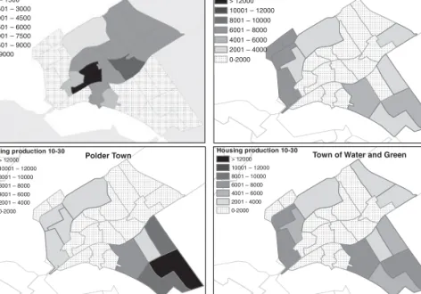
The spatial development in Almere Water Town is very much oriented towards a land development programme to the west of the existing town of Almere. This land development project consists of land reclamation in the IJmeer/Markermeer, directing the focus of urban development to the western part of Almere. The land development project comprises 15 000 dwellings and 7000 jobs on new reclaimed land (an artifi cial island called Almere IJland) and 20 000 and 10 000 jobs inside the dikes (Almere Pampus). In addition to the housing production on reclaimed land areas, part of the housing production target takes place in the existing town
(11 000 dwellings and 30 000 jobs) and greenfi eld sites east of the town (14 000 dwellings and 11 000 jobs), as shown in Figure 8.2. The public transport programme includes the construction of a new IJmeer railway link, connecting Almere to Amsterdam and Amsterdam Airport Schiphol with a regional rail link through Lake IJmeer (see Figure 8.1). The new rail link has been examined with diff erent train types (local train, metro and maglev). In this chapter, the focus is on the alternative with local train services (Regiorail).
To disentangle the eff ects of the land- use changes and public transport investments on accessibility, sensitivity runs using Tigris XL were con-ducted to estimate the land- use scenario Water Town with and without the new IJmeer rail link, as well as the reference scenario with and without the new IJmeer link.
Almere Polder Town scenario
In this scenario, urban growth is oriented towards greenfi eld development to the east of Almere (35 000 dwellings and 16 000 jobs). But urbanization
Housing supply 0 – 1500 1501 – 3000 3001 – 4500 4501 – 6000 6001 – 7500 7501 – 9000 > 9000 Housing production 10-30 > 12000 10001 – 12000 8001 – 10000 6001 – 8000 4001 – 6000 2001 – 4000 0-2000 Polder Town Water Town
Town of Water and Green Situation 2010 Housing production 10-30 > 12000 10001 – 12000 8001 – 10000 6001 – 8000 4001 – 6000 2001 – 4000 0-2000 Housing production 10-30 > 12000 10001 – 12000 8001 – 10000 6001 – 8000 4001 – 6000 2001 - 4000 0-2000
Figure 8.2 Clockwise from top left: housing supply in 2010, housing production between 2010 and 2030 in the scenarios Almere Water Town, Almere Town of Water and Green and Almere Polder Town
also takes place in the existing town (11 000 dwellings and 30 000 jobs), and in the western quarter (14 000 dwellings, without land reclamation). The public transport investments include an upgrade of the existing rail link across the Hollandse Brug (southwest) and the construction of a new rail link, the Stichtselijn, connecting Almere to Hilversum and Utrecht by regional rail, to the south. The western part of the town will not have a direct rail connection. The development to the east of the town requires an upgrade of the road network as well (an additional third lane on each direction on the A27 from Almere to the south).
Almere Town of Water and Green scenario
In this scenario the urban growth takes place more evenly across the town. To the west, Almere will grow by 20 000 dwellings, but without land reclamation, and 16 000 dwellings are built within the existing town of Almere. To the east, greenfi eld development will take place (24 000 dwellings) scattered around three smaller urban centres. The public trans-port investments include an upgrade of the existing rail link (across the Hollandsebrug).
8.4 POPULATION AND EMPLOYMENT CHANGES
Population and Employment Eff ects of Land- Use Plans
The eff ects of the land- use plans for Almere on population and employ-ment were compared to the reference scenario. The housing production program of 60 000 new dwellings in Almere leads to a population growth of around 122 000 inhabitants between 2010 and 2030, more than dou-bling the growth in inhabitants as compared to the reference case (30 000 houses and 55 000 inhabitants). In the reference case, a substantial part of the housing programme facilitates additional housing demand that follows from the general trend of a decrease in household size in addition to off ering new dwellings to households migrating to Almere from the surrounding region. In Almere, this average household size is expected to decrease from 2.5 persons per household in 2010 to 2.37 persons in 2030. This is above the national average, and follows from the high rep-resentation of young families in this relatively new town, facilitating part of the housing demand surplus for this group in the region (mainly from Amsterdam).
The ambition of the development scenarios for Almere is to create 100 000 additional jobs in the period up to 2030, in addition to 60 000 houses. There is a long tradition of government planning of large
residential development in the Netherlands, and the realization of the 60 000 houses can be infl uenced by the government. However, the ambi-tion to create 100 000 jobs is much more diffi cult to realize, since the infl uence of the government on the location choice of fi rms is very small in the Netherlands. Therefore, simulations were made with the Tigris XL model, assuming the 60 000 houses were constructed, to calculate the eff ects on population and employment. For all three scenarios, the calcu-lated employment growth is much lower than 100 000 with an increase in number of jobs of only 46 000 forecasted between 2010 and 2030.
Compared to the reference case, there is an additional 23 000 jobs in the Almere development scenarios. At a more detailed level of economic sectors, the Tigris XL model simulates the development for seven eco-nomic sectors. The fastest- growing sectors in response to the housing plans are, as expected, population- related sectors such as the retail and government sectors. However, sectors such as logistics and business services (8500 additional jobs) also grow since these sectors are indirectly infl uenced by the population development.
The employment growth of 46 000 jobs compared to 2010 slightly infl u-ences the residential character of the town by increasing the ratio between employment and labour population from 0.66 to 0.73 jobs per worker. In theory, Almere will still have more commuters leaving the town than entering in the morning peak, and vice versa in the evening peak. This is in contrast with other large cities in the Netherlands, most of which have a net inward stream of commuters. Therefore, the town of Almere is likely to keep its function as a dormitory community to Amsterdam and, to a lesser extent, Utrecht.
Regional Population and Employment Eff ects
The development scenario for Almere eff ected the size of the population and number of jobs in municipalities surrounding Almere. The Tigris XL model is a distribution model which assumes that the number of people and jobs at the national level is an exogenous scenario input. Therefore, an increase in inhabitants and jobs in Almere results in a decline in other municipalities. The largest change in population and jobs is in the Amsterdam and Utrecht region. About 75 000 additional inhabitants in the development scenario for Almere predominantly originate from the Amsterdam or Utrecht region. The addition of 23 000 jobs in the Almere development scenario (compared to the reference scenario) is mainly at the cost of the job growth in municipalities within a radius of 50 kilometres of Almere. The directly neighbouring municipalities to the south benefi t slightly from the additional urban developments in Almere. Business
sectors for these municipalities especially benefi t, with an overall result that is positive. The largest changes in the number of jobs occur in the greater Amsterdam and Utrecht region. In the Amsterdam region, most losses are within the town itself, while in the Utrecht region losses are bigger in municipalities surrounding Utrecht town.
Transport investments can also have an impact on the spatial distribu-tion of residents and jobs. The populadistribu-tion eff ects of the public transport project examined are marginal (0.3 per cent change or less) compared to the total population growth between 2010 and 2030. This is due to the assumption that housing and real- estate supply are fi xed, regardless of the public transport investments. Therefore, population eff ects only result from changes in the location preferences of the relocating households, and not from a change in housing supply.
The distribution of jobs is more responsive to changes in accessibility by public transport projects. Public transport improvements increase the logsum accessibility from the mode and destination model, with a sig-nifi cant location factor for economic sectors such as industry, consumer services and business services. The strongest employment growth for Almere is accomplished in the Polder Town scenario when the Hollandse Brug rail link is upgraded and the new Stichtselijn rail link is built. The public transport improvements lead to a redistributive eff ect of employ-ment from the Amsterdam and Utrecht region to Almere, resulting in a jobs increase of about 1.5 per cent (1600 jobs) in Almere compared to the Polder Town reference scenario. The IJmeer rail link in the Water Town leads to an employment increase in Almere of about 0.9 per cent, jobs, and modest public transport investments programmes in the Town of Water and Green scenario result in an increase of about 0.4 per cent. These employment eff ects of the public transport investments are signifi cant, but relatively small compared to the total employment growth between 2010 and 2030. In regions with well- developed infrastructure networks these eff ects can be expected to be small (Banister and Berechman, 2000; SACTRA, 1999).
8.5 ACCESSIBILITY
BENEFITS
Accessibility Benefi ts of the Public Transport Projects
Accessibility benefi ts are calculated as the diff erence between a run with the public transport investment projects and the reference scenario of each corresponding spatial growth scenario. In addition to the three standard investments programmes (one for each spatial scenario), the travel time
benefi ts of the IJmeer regional rail link are calculated from two sets of sen-sitivity runs. Table 8.1 shows the accessibility benefi ts for train passengers using the rule- of- half and logsum measures of accessibility benefi ts.
The travel time benefi ts of the combined Stichtselijn construction and upgrade of the Hollandsebrug rail link are comparable to those of the IJmeer rail link. Travel time benefi ts were computed to be around €55 million yearly according to the rule- of- half, and around €70 million using the logsum methodology. The logsum benefi ts are slightly higher compared to the conventional rule- of- half (20 per cent to 30 per cent). As noted earlier, in theory, when land use is fi xed, the rule- of- half and logsum benefi t estimations will only diff er slightly when computed at the same level of aggregation. The diff erences can be attributed to a more exact computation of the logsum measure; the logsum is computed at the same level of disaggregation as the mode- destination model, uses non- linear demand functions, and all changes in all mode and destination alternatives are weighed simultaneously.
Similar to the standard calculations applied with the regional transport (Zwaneveld et al., 2009), the assignment results were not accurate enough to predict the minimal travel time reductions on the car network due to a modal shift from public transport improvements. Therefore, these results were not included in the project evaluation.
Accessibility Benefi ts of the Land- Use Scenarios
Each spatial scenario can lead to accessibility benefi ts due to the more effi cient distribution of population and employment in the urban
Table 8.1 Rule-of-half and logsum accessibility benefi ts for train users, 2030 (in million euro a year)
Scenario Reference scenario Rule- of- half Logsum
Train Train
New IJmeer rail link in
Water Town
Water Town reference 55.9 72.9
New IJmeer rail link in Water Town without road
pricing scheme
New IJmeer rail link in Water Town with road pricing scheme
53.4 69.0
Hollandsebrug Regiorail and Stichtse rail in Polder
Town
Polder Town reference 55.8 67.6
Hollandsebrug Regiorail in Town of Water and Green
Town of Water and Green reference
confi guration. Table 8.2 presents diff erences in accessibility benefi ts calculated between the three Almere growth scenarios and the refer-ence scenario without population and job growth and public transport projects.
The accessibility benefi ts for the diff erent land use scenarios are signifi -cantly larger than the accessibility benefi ts of the public transport invest-ments. Almere Polder Town shows the largest accessibility benefi ts of €132 million per year; the Almere Water Town scenario yields a total of €113 million per year; and Almere Town of Water and Green about €90 million per year. The shift of urban development to the Almere region mainly leads to accessibility benefi ts for car (drivers and passengers) and train travellers. When planned motorway expansions are realized, Almere will be well accessible by car and train as compared to other neighbourhoods in the region that suff er more from congestion due to the existing high level of urbanization. The negative accessibility benefi ts for the slow modes (walking and cycling) mainly arise in relation to commuting. Almere is a residential town with a low employment to labour force ratio, even after the urban growth. The relative small number of jobs at close distance gives the commuting logsums a relatively lower value, translating into accessibility disbenefi ts for commuting by slow mode for residents who choose Almere as residential location instead of other cities (for instance, Amsterdam).
8.6 SYNERGIES IN ACCESSIBILITY BENEFITS
BETWEEN THE LAND- USE POLICY
ALTERNATIVES AND RAIL INVESTMENTS
In this section we examine the eff ect of the urbanization variants on the accessibility benefi ts of the rail project alternatives. Two eff ects can be distinguished. Firstly, there is a volume eff ect resulting from the additional
Table 8.2 Logsum accessibility benefi ts from each spatial scenario compared to the reference scenario without housing programme in Almere, 2030 (in million euro a year)
Logsum travel time benefi ts Transport mode
Train Car BTM Slow Total
Almere Water Town 30.9 159.3 0.5 −76.6 113.9
Almere Polder Town 53.3 92.4 44.1 −58.8 131.9
population and job growth in Almere (growth of 30 000 dwellings and 22 000 jobs compared to the reference scenario). Tigris XL was used to estimate the Water Town land- use scenario with and without the new IJmeer rail link, and the reference scenario with and without the new IJmeer link. Both the rule- of- half and logsum accessibility measure were computed. The results are presented in Table 8.3.
Secondly, a location eff ect can be distinguished, referring to the diff er-ence in accessibility benefi ts resulting from the diff erent allocations of the population and job growth between the three land- use policy scenarios for Almere (with fi xed total population and job growth). This can be analysed comparing the accessibility benefi ts of a given public transport project for diff erent spatial variants. This analysis was not conducted with Tigris XL, but in the CBA (Zwaneveld et al., 2009), the rule- of- half accessibility ben-efi ts for two public transport project alternatives (the IJmeer rail link and the upgrade of the existing rail link) were estimated for two spatial vari-ants: Almere Water Town and Almere Water and Green (see Table 8.3).
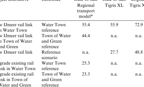
Table 8.3 shows that for the new IJmeer rail link, the volume eff ect is stronger than the location eff ect. The magnitude of the eff ect is strongly related to the magnitude of the land- use change near the new railway stations of the new IJmeer railway link. The diff erence in urbanization
Table 8.3 Rule- of- half and logsum accessibility benefi ts for train users, 2030 (in million euro per year)
Project alternative Reference Rule- of- half Rule- of- half Logsum
Regional transport model*
Tigris XL Tigris XL
New IJmeer rail link in Water Town
Water Town reference
55.4 55.9 72.9
New IJmeer rail link in Town of Water and Green Town of Water and Green reference 44.4 n.a. n.a.
New IJmeer rail link Reference
scenario
n.a. 27.7 48.8
Upgrade existing rail link in Water Town
Water Town reference
25.3 n.a. n.a.
Upgrade existing rail link in Town of
Water and Green
Town of Water and Green reference
23.3 n.a. n.a.
between Water Town and the reference scenario (volume eff ect) relates to adding 30 000 dwellings and 22 000 jobs to the new quarter in the western part of Almere, which is well connected to the new rail link. This increases the accessibility benefi ts of the new IJmeer rail link by about 50 to 65 per cent according to the rule- of- half and logsum measure, respectively. The location eff ect relates to the diff erences in locations of dwellings and jobs between Water Town and Town of Water and Green. The main diff er-ence between the policy scenarios is that in Water Town, 15 000 dwellings and 7000 jobs are added to the new western quarter of Almere, which is well connected with the new railway link, whereas in Town of Water and Green, they are located in the eastern part of Almere and are not con-nected to the new rail link. This increases accessibility benefi ts by about 25 per cent. The benefi ts are about €55 million in Almere Water Town in 2030, and €44 million in Almere Water and Green for the year 2030.
Table 8.3 also shows that the (rule- of- half) accessibility benefi ts for the upgrade of the existing rail link hardly diff er between the Water Town and Town of Water and Green land- use policy scenarios. Both scenarios do not diff er in population and job developments in the existing built- up area near the railway stations of the current railway link.
Finally, Table 8.3 shows that the rule- of- half accessibility benefi ts resulting from the new IJmeer rail link, as computed by Tigris XL, are very similar to those used in the cost–benefi t analysis and computed by the regional version of the transport model. This is not surprising, since the regional transport model is a regional version of the national transport model included in Tigris XL.
It can thus be concluded that signifi cant synergies can be found when land- use policies and public transport investments are integrated. However, the additional accessibility benefi ts are small compared to the investment costs and do not signifi cantly aff ect the cost–benefi t ratio of the public transport projects. The investment costs of all rail project alternatives are high, ranging from €2.9 to 6 billion. The project alter-natives with new railway links are obviously the most expensive (€4 to 6 billion) as they involve construction of a new bridges and/or tunnels connecting Amsterdam to Almere. Upgrading the existing railway link (Hollandsebrug) is also quite expensive (€2 to 3 billion) due to the complexity of construction.
The CBA showed that the accessibility benefi ts do not even outweigh maintenance and operational costs. All rail projects examined in the CBA have strong negative welfare eff ects, mainly due to the high investment costs. Welfare losses for all public transport projects examined in the CBA range from €1.2 to 3 billion (net present value) (Zwaneveld et al., 2009). There are three main reasons for this result. Firstly, investment costs of the
projects are quite high because they involve large and complex construc-tions. Secondly, the rail service level is already strongly improved with planned investments (reference scenario), so additional investments show marginal returns. Thirdly, the new railway links reduce travel times to Amsterdam for residents in the new housing locations in Almere (up to 17 minutes), but not for existing residents in Almere (one minute or less). It is very diffi cult to achieve positive welfare gains for a new – and expensive – railway link when only a small part of the total population will profi t, that is, the residents living near the new railway station planned in the new housing location Almere Pampus.
8.7 CONCLUSIONS AND DISCUSSION
Applying the land- use–transport interaction model, Tigris XL, enables the examination of the land- use, transport and accessibility impacts of integrated land- use and transport policy plans, in this case land- use policy variants for large- scale housing development in Almere with dedicated public transport investment programmes. Conclusions of the study can be drawn regarding the population and employment eff ects of the land- use and transport plans and regarding their accessibility benefi ts following the logsum method in comparison with the rule- of- half method.
Regarding the population and employment eff ects, two main conclu-sions can be drawn. Firstly, the Almere case of the construction of 60 000 houses results in an increase of 120 000 to 130 000 residents and just under 50 000 jobs. It is unlikely that the policy ambition of local governments to attract 100 000 jobs in Almere can be realized. Secondly, the major public transport projects examined result in minor increases in employment for the city of Almere. The impact on the number of residents is even smaller, but this is partly caused by the exogenous control of the number of houses in the development plans.
Regarding the accessibility benefi ts, three main conclusions can be drawn. Firstly, the diff erent land- use policy alternatives for Almere result in signifi cant logsum accessibility benefi ts, in the range of €90 to €130 million per year relative to the reference scenario. The logsum accessibil-ity benefi ts from the land- use scenarios for Almere exceed those from the railway investments. This illustrates that land- use policies can eff ectively increase accessibility for travellers by increasing the number of activities which can be reached with constant (generalized) travel costs. These acces-sibility benefi ts are not measured by the traditional rule- of- half benefi t measure of accessibility benefi ts. The rule- of- half measure also does not capture all benefi ts from the public transport investments.
Secondly, the logsum benefi ts of the public transport projects exam-ined, given a land- use scenario, are slightly higher than the benefi ts measured with the conventional rule- of- half (20 to 30 per cent). This diff erence is plausible; the logsum is a more comprehensive measure in which the changes in all mode and destination alternatives are weighed simultaneously.
Thirdly, signifi cant synergies can be found when land- use policies and public transport investments are better integrated. Adding dwellings and jobs to locations near railway stations can signifi cantly increase accessibil-ity benefi ts for public transport users. However, in our case study, this does not aff ect the outcome of the CBA since the synergy in accessibility benefi ts is small compared to the huge investment costs of the public trans-port projects examined. All rail projects examined in the CBA continue to have strong negative welfare eff ects.
The accessibility benefi ts estimated in this chapter provide a partial picture of the total economic eff ects of expansion of Almere and infra-structure investments. The wider economic benefi ts (such as agglomera-tion benefi ts and better- funcagglomera-tioning labour markets) are not estimated, but can be very important. In the CBA of the public transport invest-ments (Zwaneveld et al., 2009), the wider economic impact of the rail investments were included (assuming a fi xed 30 per cent rise to the trans-port benefi ts), but the wider economic impacts of the land- use scenarios were not estimated. In theory, agglomeration and productivity gains increase with city size and density of employment (DfT, 2005). The wider economic impacts of further urbanization in Almere are not trivial and can be positive or negative, depending on the reference situation (for example, build dwellings in small towns or, in contrast, in Amsterdam with relatively high employment densities). Examining the size and the direction of these agglomeration eff ects is an important direction for further research.
NOTE
1. Translated from the original Dutch names: Waterstad, Polderstad and Stad van Water en Groen.
REFERENCES
Bakker, P., Zwaneveld, P., 2010. The importance of public transport: the societal eff ects delineated. World Conference on Transportation Research, WCTR.
Banister, D., Berechman, J., 2000. Transport Investment and Economic
Development. University College London Press, London.
Bates, J., 2006. Economic evaluation and transport modelling: theory and prac-tice. In: Axhausen, K.W. (ed.), Moving through Nets. The Physical and Social
Dimensions of Travel. Selected papers from the 10th International Conference
on Travel Behaviour Research. Elsevier, Kidlington/Amsterdam, pp. 279–352. De Jong, G., Daly, A., Pieters, M., van der Hoorn, T., 2007. The logsum as an
evaluation measure: review of the literature and new results. Transportation
Research Part A: Policy and Practice 41, 874–889.
DfT, 2005. Transport, wider economic benefi ts and impacts on GDP. Department for Transport, London.
Geurs, K.T., Van Wee, B., Rietveld, P., 2006. Accessibility appraisal of integrated land- use/transport strategies: methodology and case study for the Netherlands Randstad area. Environment and Planning B: Planning and Design 33, 639–660. Geurs, K., Zondag, B., De Jong, G., De Bok, M., 2010. Accessibility appraisal of
integrated land- use/transport policy strategies: more than just adding up travel time savings. Transportation Research Part D 15, 382–393.
Ministry of Transport Public Works and Water Management, 2007. Randstad Urgent (in Dutch), The Hague.
Neuburger, H., 1971. User benefi ts in the evaluation of transport and land- use plans. Journal of Transport Economics and Policy 5, 52–75.
RAND Europe, 2006. TIGRIS XL 1.0 [in Dutch]. Rand Europe, Leiden.
SACTRA, 1999. Transport and the economy. The Standing Advisory Committee on Trunk Road Assessment. Department of the Environment, Transport and the Regions, London.
Simmonds, D.C., 2004. Assessment of UK land- use and transport strategies
using land- use/transport interaction models. European Journal of Transport and
Infrastructure Research 4, 273–293.
Waddell, P., Ulfarsson, G.F., Franklin, J.P., Lobb, J., 2007. Incorporating land use in metropolitan transportation planning. Transportation Research Part A:
Policy and Practice 41, 382–410.
Zondag, B., 2007. Joint modeling of land- use, transport and economy. PhD thesis. Delft University.
Zwaneveld, P., Romijn, G., Renes, G., Geurs, K., 2009. Maatschappelijke kosten en baten van verstedelijkingsvarianten en openbaarvervoerprojecten voor Almere (Social costs and benefi ts of urbanisation variants and public transport projects for Almere). CPB Bureau for Economic Policy Analysis and Netherlands Environmental Assessment Agency, The Hague.