LESSONS LEARNED FROM
SPATIAL PLANNING IN THE
NETHERLANDS
In support of integrated landscape initiatives, globally
Background Report
Alexandra Tisma and Johan Meijer
Lessons learned from spatial planning in the Netherlands. In support of integrated landscape initiatives, globally.
© PBL Netherlands Environmental Assessment Agency The Hague, 2018
PBL publication number: 3279
Corresponding author
Alexandra.Tisma@pbl.nl
Authors
Alexandra Tisma and Johan Meijer
Supervisor
Keimpe Wieringa
Acknowledgements
The authors greatly appreciate the input and feedback from PBL colleagues Marc Hanou, Rienk Kuiper and Leo Pols. We thank Jade Appleton (Delft University of Technology) for her work on the Green Heart illustrations that enrich this report. For sharing his experience and insights into the history and management of the landscape of the Dutch Green Heart, we thank Theo van Leeuwen of De Groene Klaver.
Graphics
Alexandra Tisma and Jade Appleton
This publication can be downloaded from: www.pbl.nl/en. Parts of this publication may be reproduced, providing the source is stated, in the form: Tisma A. and Meijer J. (2018), Lessons learned from spatial planning in the Netherlands. In support of integrated landscape initiatives, globally. PBL Netherlands Environmental Assessment Agency, The Hague.
PBL Netherlands Environmental Assessment Agency is the national institute for strategic policy analysis in the fields of the environment, nature and spatial planning. We contribute to improving the quality of political and administrative decision-making by conducting outlook studies, analyses and evaluations in which an integrated approach is considered paramount. Policy relevance is the prime concern in all of our studies. We conduct solicited and
Contents
SUMMARY OF MAIN FINDINGS
4
1
INTRODUCTION
6
1.1 A landscape approach to sustainable development 6
1.2 Goal of this study 7
1.3 Integrated landscape management 7
1.4 Landscape as a socio-ecological system 9
2
SPATIAL PLANNING IN THE NETHERLANDS
11
2.1 The need for spatial planning in the Netherlands 12
2.2 From hierarchical to network governance in spatial planning 14
2.3 Integration in spatial planning 16
3
RECENT DEVELOPMENTS IN NATIONAL SPATIAL PLANNING
19
3.1 Nature versus landscape protection 26
3.2 Spatial planning ‘new style’ 27
4
THE CASE OF THE GREEN HEART OF RANDSTAD
29
4.1 Green Heart during the hierarchical planning period 31
4.2 Green Heart in the network planning period 33
5
CONCLUSION: LESSONS WITH LANDSCAPE IN MIND
37
6
REFERENCES
39
Summary of main
findings
Integrated Landscape Management (ILM) is a process in which multi-stakeholder platforms manage the ecological, social and economic interactions between various parts of the landscape, in order to realise positive synergies between interests and actors or mitigate negative trade-offs. Spatial planning is seen as an important instrument that could support the ILM process.
This study illustrates the role of spatial planning in landscape management and development in the Netherlands, focusing on examples on national and regional scales. Driven by the need to improve multifunctional land-use planning and to overcome the limitations of a sectorally organised national government, an integrated way of spatial planning has been applied in the Netherlands since the mid 1980s. The first part of that period was characterised by a
hierarchical governance style that gradually transformed into network-oriented governance. These two ways of governance were characterised by different types of spatial planning policies and, consequently, had a different impact on landscape management.
Lessons learned from hierarchical governance
This type of governance was top-down, supported by stringent legislative and financial instruments that made policy implementation relatively easy. It was directed to development
control planning. This planning style was favoured by many spatial planners. Experience has
shown that:
• A stable and long-term-oriented policy on spatial planning is seen as an important foundation for preserving spatial quality and maintaining regional economic stability. • Long-term protection and promotion of landscape values raises awareness among
citizens and entrepreneurs about the need for a more integrated perspective. • Hierarchical planning on a national level controls the quality of large-scale projects of
supra-regional importance.
But hierarchical governance also had its negative sides; it was criticised for its ‘blueprint’ way of planning which proved to be rigid in its response to political changes and societal needs. During the 1980s, a new approach to spatial planning emerged: Development planning. Although still retaining most of the features of hierarchical governance, development planning was more sensitive to social dynamics, had decentralised implementation, paid attention to economics, included citizen participation and cooperation between public and private actors.
During the past 10 years many national governmental functions were decentralised to
provinces, top down landscape planning policy was deregulated and network governance now determines spatial planning.
Lessons learned from a networking way of governance
The ambition of the Dutch Government’s network planning style is to achieve shared responsibility on spatial quality, in terms of both finance and legislation. To facilitate the integration, all related legislation has been combined under one law: the Environment and Planning Act (Omgevingswet). Network governance in spatial planning in the Netherlands is
still a relatively new, dynamic and ongoing process; therefore, it is too early to draw hard conclusions on its success or failure. The current situation is that:
• the role of the national government has shifted from governing to stimulating and facilitating the planning processes of regional and local authorities, while remaining closely involved in managing supra-regional spatial developments.
• although citizens and NGOs play an important role in these projects, they are always supported by governmental measures, such as on funding, compensation or
legislation.
• the number of integrated landscape management initiatives by citizens and private sector has increased over the past decade. Compared to the larger number of initiatives by the government in the days of hierarchical governance, there is still room for improvement. The new initiatives tend to cover a smaller scale or area. • integral projects are inherently complex, which is why government authorities are
continually trying to simplify rules and regulations and provide more transparency. This transformation requires the support of municipalities, potentially adding to their already increasing workload and responsibility.
Supporting landscape initiatives, on a global level
Both spatial and landscape planning are dynamic processes that, also in the Netherlands, anticipate on and adapt to the changes within society. Certain elements are key in supporting these changes. For example, a well-organised land registry (cadastre) that provides clarity on land ownership and facilitates processes such as land consolidation, spatial planning and land-related investments, all contributing to economic development. Recent decentralisation of spatial-planning-related policies have clearly put more pressure and responsibility on regional and local authorities. This requires sufficient funding and expertise for policy implementation. In addition, regional and local authorities should be able to create a level playing field for all stakeholders to participate in the planning process. As seen from the case of the Green Heart, stakeholders could set up their own platform to formulate shared ambitions and develop a landscape vision. In this way, they could become important participants in spatial planning discussions that facilitate a more inclusive planning process.
1 Introduction
1.1 A landscape approach to sustainable development
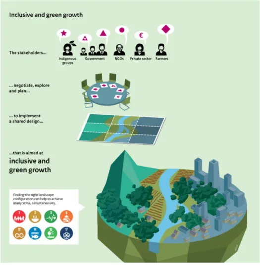
A growing demand for land, water and natural resources combined with human-induced climate change have put an increasing pressure on nature. Spatial planning plays animportant role in managing the competing claims on often scarce resources and is commonly considered a role for the government and coordinated at the national level. During the past few years however, the landscape approach has been put forward as an instrument for promoting inclusive green growth by searching for shared solutions to many development challenges that converge on a landscape level. So nowadays globally, the landscape is increasingly seen as the spatial scale on which many stakeholders, from different sectors and from global to local, need to cooperate (Figure 1).
Figure 1. Inclusive Green Growth aims to achieve multiple sustainable development goals simultaneously by finding shared solutions at the landscape level (adapted from People and the Earth, PBL 2017).
A landscape approach aims to ensure the realisation of local level needs while also considering goals and outcomes important to stakeholders outside the landscape, such as national governments or the international community (Van der Horn and Meijer, 2015).
The spatial extent of a landscape approach is often determined by an issue, benefit or risk that is commonly acknowledged by different stakeholders in a certain area. Local balancing of competing interests, sharing benefits and mitigating perceived collective risks are prerequisites to achieving multiple agreed goals simultaneously. So similar to spatial planning, the landscape approach aims to find shared solutions. This requires local, regional and sometimes even international negotiations between many diverse stakeholders,
including farmers, NGOs, indigenous communities and different levels of government. Creating an enabling environment that provides a level playing field for all stakeholders is still considered an important role for the government.
1.2 Goal of this study
This study forms the second part of a PBL research project on exploring Integrated
Landscape Management as a potential means of achieving progress on multiple sustainable development goals simultaneously. The first part of the project looks at the potential of combining spatial modelling and participatory scenario development as tools to explore potential progress on those goals in three ongoing landscape initiatives, in Honduras, Ghana and Tanzania, which are supported by the Dutch Ministry of Foreign Affairs.
The main target audience for this study consists of policymakers and stakeholders involved in the landscape initiatives in partner countries of the Netherlands or via the Landscapes for People Food and Nature (LPFN) initiative, the NLandscape.nl platform and/or other integrated landscape programmes globally.
The study presents some insights derived from key moments and policy changes in the Netherlands and reflects on the challenges ahead, signifying that, also in the Netherlands, spatial and landscape planning are dynamic processes that anticipate and adapt to changes in society. The study discusses the landscape planning policy and practice of the last three decades, since its approach shifted from a sectored to a more integrated approach. It focuses on two spatial scales: national and regional. After a short introduction of the context in this chapter, the study first focuses on the transformation of spatial and landscape
planning policy on the national level (Chapter 2) and then it zooms in on the Green Heart region to see how these changes have influenced this region and how various stakeholders have anticipated on these developments (Chapter 3). It is not the goal of this study to provide a blue print for spatial planning across the world. Rather, by underlying the
successes as well as the shortcomings of Dutch spatial and landscape planning practice, the study shares a number of lessons that could support and inspire policymakers, planners and stakeholders involved in integrated landscape planning initiatives globally, in their ambition to develop shared understanding among stakeholder platforms and to effectively implement their collaborative planning ideas into formal spatial planning processes (Chapter 4).
1.3 Integrated landscape management
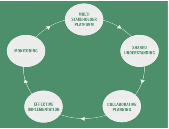
New forms of multi-actor governance have emerged in the field of global sustainable development. Businesses, civil society, and engaged citizens increasingly collaborate in multi-actor initiatives and became ‘new agents of change’ where power and steering capacity is distributed among a plethora of public and private actors that collaborate in a network of institutions, on various levels. The concept of Integrated Landscape Management (ILM) centres around the processes of managing multi-stakeholder platforms (Figure 2). To build on and stimulate such multi-actor platforms, governments need to create the right conditions
for societal initiatives to develop, learn and deliver on public goals. The role of such an enabling and facilitating government involves: positioning on targets and objectives, creating the right infrastructure, rewarding frontrunners, setting dynamic regulations, choosing the right financial instruments for behavioural change, and organising monitoring and feedback. ILM promotes a holistic approach where landscape is considered a scene in which various actors operate within their sectors, while being aware of and respecting other sectors, so to jointly improve the quality and sustainability of their shared landscape. There is increasing attention in global policy fora to the idea that by managing landscapes in an integrated way, it is more likely to achieve global sustainable development in the long term (CBD, 2014; UNCCD, 2017).
Integrated Landscape Management, regardless of the ‘entry point’ for action in a particular landscape or the community of practice, has five key features (Scherr et al., 2013):
1. Shared or agreed management objectives that encompass the economic, social and environmental outputs and outcomes desired from the landscape (commonly human well-being, poverty reduction, economic development, food and fibre production, climate change mitigation, and conservation of biodiversity and ecosystem services); 2. Field, farm and forest practices are designed to contribute to those multiple
objectives;
3. Ecological, social and economic interactions among different parts of the landscape are managed to realise positive synergies among interests and actors or to mitigate negative trade-offs;
4. Collaborative, community-engaged processes are in place for dialogue, planning, negotiating and monitoring decisions;
5. Markets and public policies are shaped to achieve the diverse set of landscape objectives.
Figure 2: The cycle and elements that are part of Integrated Landscape Management. Source: Denier et al 2015)
Governments or involved stakeholders can help to lay a foundation for policy that supports ILM by taking three steps: 1) forming multi-stakeholder learning and advocacy working groups on ILM at national and sub-national levels, where appropriate, which include government and non-government actors; 2) reviewing the existing policy framework and enabling environment for ILM and 3) convening a landscape policy dialogue to identify key actions that government can take to better support ILM (Shames et al., 2017).
1.4 Landscape as a socio-ecological system
The term landscape can have many different meanings and here we highlight two extremes: (1) landscape as a spatial-perceptual meaning used by landscape planners and (2) landscape as multi-stakeholder driven approach to territorial organisation, used for instance by nature conservation organisations. The way that landscape is treated in spatial planning policy and in practice, therefore, is twofold: it is an object as well as an approach, which could be confusing as those two concepts also form an inseparable unity.
The word ‘landscape’ originates from the Dutch language. It entered the English language in the late 16th century, derived from the Middle Dutch word ‘landschap’ denoting a picture of natural scenery (Lorzing, 2001). In the five centuries that followed the paradigm landscape has had various meanings: physical, spatial, social, cultural, historical, aesthetic and/or perceptual. In many languages landscape has a dual interpretation, meaning ‘land, area or region’ as well as the ‘visual picture of view’ (De Jonge, 2009).
In recent years though, the word landscape is getting yet another meaning: it is a is often used by nature conservation organisations to name their integral and multi-actor approach to development and management of an area. The word landscape is in that case used as a metaphor to describe ‘a socio-ecological system that consists of natural and/or human-modified ecosystems, and which is influenced by distinct ecological, historical, economic and socio-cultural processes and activities’ (Denier et al.,2015). In the Netherlands current discussions about spatial planning policy are underlying the dilemma of landscape as a consequence or as a guiding principle for the spatial developments (NOVI, 2017).
In the European Landscape Convention (ELC) landscape is defined as ‘an area, as perceived by people, whose character is the result of the action and interaction of natural and/or human factors’. One can argue that in the ELC ‘landscape’ is almost the same as ‘space’ in spatial planning (Schroder and Washer, 2010). Landscape ‘planning’ in the ELC 'means a strong forward-looking action to enhance, restore or create landscapes' (Article 1f). ‘Planning’ is seen as one of the three government measures aimed at the protection,
management and development of landscapes. As such, it applies to larger scale interventions in space, such as land allocation or land consolidation, intensive agriculture or nature
development or reconstruction. No surprise that landscape planning is often considered to be at the crossroads of spatial and land use planning (Schroder and Washer, 2010). Some would argue that a landscape approach provides spatial planning with the human dimension (De Jonge, 2009). Similar to spatial planning, from which it derives a part of theoretical background, landscape planning involves integral and long-term thinking and acting in favour of the public domain (Friedman, 1989).
Landscape is also considered as ‘the field where humans and nature joust for a time’ (Nassauer, 2012) and ‘where we speed up or retard, divert the cosmic programme and impose our own’ (Jackson, 1984). The consequences of human actions are visible all around and can have impact from local to global scale. This was the reason for cherishing of
landscape protection for a long time. In more recent years, the paradigm of protection of the fabric of the past is shifting towards the management of future change (Fairclough, 2008a). These days, the landscape is an important selling point in the economic sectors of recreation and tourism. And finally landscapes often relate to emotions as for many people, the smells and colours of a landscape are an important part of their most cherished childhood
memories.
Presented views of landscape show all kinds of meanings that word landscape can have. To summarise: landscape is the interface between nature and culture and can be seen as physical object, as a perceived image, an approach, or a principle. As we will see in the text to follow, all these meanings were related to the period in the history of landscape planning development, planning styles, as well as political and social trends, and sometimes even a fashion.
2 Spatial planning in
the Netherlands
The Netherlands consists of mainly flat land. Apart from the regions in the eastern and southern extremities which are a bit higher, the majority of the territory is lying between -6 and 20 meters above sea level. Since the beginning of the last millennium, settlers, farmers, city dwellers and engineers have created a system of dykes, barriers and locks defending the low parts of the land from the water (Figure 3). As Voltaire (1694–1778) said: ‘God shaped the world, except the Netherlands. That he left to the Dutch themselves.’
Landscapes in the Netherlands are all man-made cultural landscapes. They are often considered to represent important public goods and are seen as a living, dynamic heritage (Lörzing 2001; Janssen, Pieterse and Van den Broek 2007; Pedroli, Van Doorn and De Blust 2007).
The current land use in the Netherlands is characterised by the considerable prevalence of agricultural areas (65%), almost the smallest percentage of forests in Europe (about 10%) and water (about 5%). In addition, 3,8% of ‘nature’ areas have also been created by man, often by transforming the agricultural landscape into areas for nature development with the highly mono-functional goal of protection of biodiversity.
Figure 4. Anna Paulowna polder in the province of North Holland dating from 1846 (photo: Paul Paris)
Figure 4 shows a typical lowland landscape, with the prevalence of agricultural land, the village of Kleine Sluis somewhere in the distance, a canal in the middle, as well as a mixture of crop fields, pastures and colourful flower production fields for which this country is renown worldwide. The image perfectly illustrates the four rules of Dutch spatial planning school : purpose of usefulness, economy of resources, meaning of place and clarity of form (Reh et al., 2006). Everything seems in perfect order with clear boundaries between urban and rural, neat and beautiful. However, behind this achievement there is a labyrinth of rules and regulations, policy instruments and subsidies. Creating this apparent perfection was not simple and it is the result of many successes and failures.
2.1 The need for spatial planning in the Netherlands
It is not by chance that the lessons learned presented here are derived from the Dutch experience. With about 504 residents per square kilometre, the Netherlands is after Malta the second most densely-populated country in Europe(http://www.clo.nl/indicatoren/nl2102-bevolkingsgroei-nederland-). In an economic sense, the Netherlands has been in the top 20 of the most prosperous countries of the world for decades (Van der Horst 2007; Needham 2007). The Netherlands, though small, is one of the
world’s largest exporters of agricultural products. The combination of population density and prosperity has led to extreme pressure on scarce space in this small country, making spatial planning a bare necessity to manage various (sometimes competing) spatial claims. Yet another reason for drawing lessons from the Dutch experience is that landscape has been playing an important part of the more than a hundred-year-long tradition of spatial and land-use planning, combined with the development of the cadastre1.
Textbox 1: The Dutch way of managing the landscape
View of the Vliet with the Lepelbrug in the distance. Penseeltekening van Hendrik Thier, 1768 (Archive Delft)
‘Already since the year 1000, we have been controlling the landscape, starting with the draining of swamps. We subsequently built dykes around them, which is how the first polders were created. The next step was to accelerate the accretion of fertile marshes outside the dykes, to subsequently surround them with dykes and to drain them with sluices. And finally we came up with something that could not be imagined anywhere else in the world: the creation of polders by pumping out seawater from an enclosed sea area. This is how our national identity came about: making that highly productive country. That is what our painters and cartographers started to record in the 16th century. Poets wrote about it. The elite wanted to live in those areas. People became euphoric. Foreigners who came here spoke of a hypnotic experience: sliding through the flat landscape in a barge, with that low horizon of a thousand windmills.’ (Adrian Geuze, NRC.next
‘Parijs, Londen, die koesteren hun landschap’)
Further on, there are two concepts that originate from the Dutch language and have been adopted internationally: landscape (which was explained in the previous section) and polder. Both words have to do with the physical and social aspects of planning and management of the land. The Dutch word ‘polder’ has made its way into many other languages around the world. Literally, it means ‘land reclaimed from water’, but in the common policy practice in the Netherlands it has also acquired a metaphoric meaning. The shortage of land suitable for agriculture forced people in the low parts of the Netherlands to create new polders. To build a polder is a complex task which requires cooperation, negotiation, tolerance and continuous maintenance, which is only possible if all those living in the polder agree to work together.
1The Netherlands’ Cadastre (Kadaster) collects and registers administrative and spatial data on property and the rights involved. Doing so, Kadaster protects legal certainty. Kadaster is also responsible for national mapping and maintenance of the national reference coordinate system. Furthermore, Kadaster is an advisory body for land-use issues and national spatial data infrastructures.
That is why the so-called ‘polder model’ became a metaphor for a culture of negotiation and consensus in this country.
The Netherlands became known for its knowledge and technical skills in coping with complex spatial problems, and planning has always been seen as a convenient instrument to deal with this complexity. During the more than one hundred-year-long tradition, spatial planning in the Netherlands has gone through various stages and seen several planning styles.
2.2 From hierarchical to network governance in spatial
planning
In the years after the Second World War, planning involved a top-down, hierarchical perspective, with a focus on government-led land-use planning. In the Netherlands, there were then—and still are today—three levels of government: national, provincial and
municipal. In the area of spatial planning, each of these levels involves specific tasks. One of the most important planning instruments is land use. Land-use planning uses zoning maps and land-use regulations that offer the government the possibility of preventing undesirable forms of land use. This form of planning, which uses prohibitions, is called development control planning, with an emphasis on control (Van der Valk, 2010). Spatial plans of that period were considered blueprints.
Most government administrations in the Netherlands, at that time, were organised according to individual sectors (e.g., agriculture, environment, rural development, water, etc.) and jurisdictions. That multifunctional land use planning could only start after 1985 had to do with the power relationships between various ministries (Pols, 2015). In 1985 for instance, landscape planning related to rural area and was under the jurisdiction of the former Ministry of Agriculture and Fishery, nature and recreation were part of the former Ministry of Culture, Recreation and Social affairs, while spatial planning was under the former Ministry of
Housing, Spatial planning and the Environment. This led to many problems, and spatial planning as an interdisciplinary science has been trying to overcome this situation by working cross-sectoral. It was clear that cooperation between the ministries was needed. By the end of the 1980s, it was already clear that traditional practice of national
government-led land-use planning no longer provided an answer to the forces of the contemporary fluid and extreme mobile network society. By the end of 1990s, development control planning encountered growing resistance from society, which led to some of the nationally applied polices being accompanied by financial compensation. The more flexible development planning (onwikkelingsplanologie) style was invented by the national
government. This planning style, although still containing many elements of hierarchical governance, was taking into account the dynamics within society, decentralised
implementation, attention for economics, citizen participation, more attention for concrete projects than for abstract plans, and the cooperation between public and private actors (Van der Valk, 2010).
The period of hierarchical governance yielded important large-scale achievements of landscape and nature conservation: the National Ecological Network (NEN) and the national buffer zones (most of them still in place, today). Also, the 20 selected landscapes
characterised by combinations of typical Dutch cultural and natural elements (the so-called national landscapes), were established in that period. For a while, it looked as if landscape planning was formally and firmly integrated in national spatial planning policy, but this did not last long.
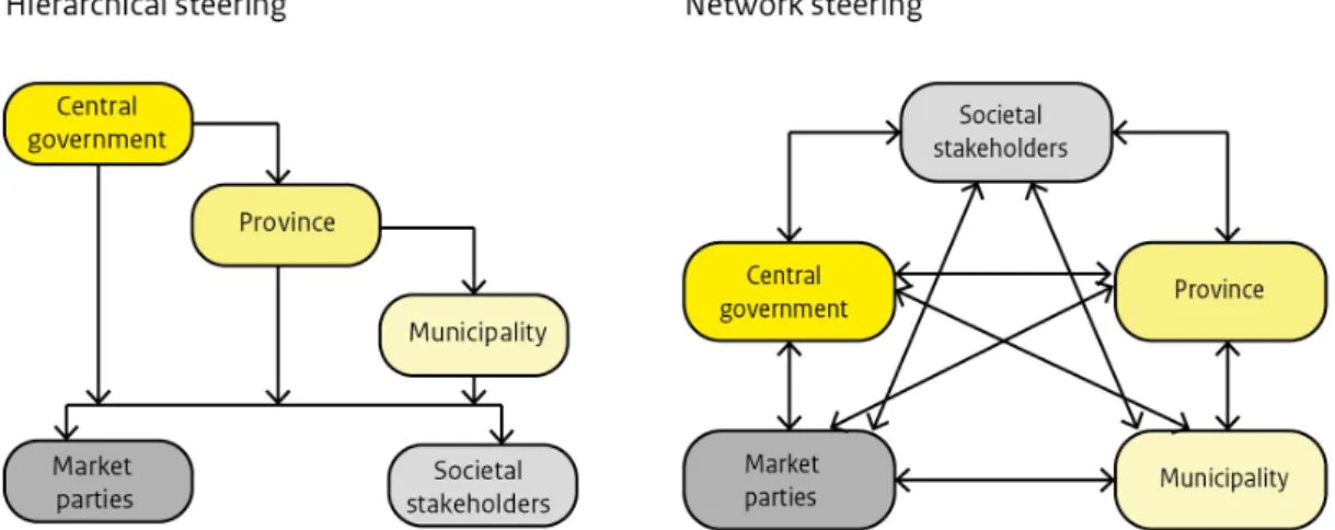
Figure 5: From hierarchical governance (left) to network governance (right) (Source: adapted from Dijk, 2006)
During the 1990s, the role of provinces in policy-making and planning projects increased due to decentralisation of responsibilities and tasks from the national to provincial governmental level. The provinces started acting as mediator between national policy design and local policy implementation and gained a permanent role in planning projects crossing municipal border. Citizens, NGOs and market parties were more and more involved in the planning processes, which gradually led to the network way of governance (Figure 5). Besides realising desired land uses, landscape quality became planning objective as well, which considerably changed the way that land use and land consolidation plans were made. Although integrative projects have been part of the Dutch planning tradition for a longer period of time, it was clear that cooperation between the ministries was needed. In 2006 this resulted in the new Spatial Memorandum (Nota Ruimte, 2006), which was collaboratively published by four ministries, and included the concept of integration as an objective of the national government (Ministry of Housing, Spatial Planning and the Environment, 2006). To implement this objective, ‘integral spatial development’ was introduced as a new planning concept. The integral spatial development had to deal with several planning issues, including integration, transparency, openness, and participation (Louw et al., 2003; Boelens and Spit, 2006).
Since spatial planning policy became more integral, formerly strongly protected nature areas were gradually opening to recreational needs of citizens, and nature protection was
broadened to cultural landscape development. In the years to come, the tension between preserving and developing landscapes is being acknowledged as a social and physical challenge, which required policy and practice to work together. Provinces were actively involved in integrated planning processes, including (strategic) acquisition of land and high risk investments in development projects (Van Straalen et al., 2015). As the selected level for optimal integrated planning, the Dutch regional planning authorities started many integrated spatial planning projects in which integration was expressed as the main objective, in order to guarantee the success of projects. But as a result of economic
setbacks, many of these projects have come to a standstill, mainly due to their large-scale, time-consuming, risky, and therefore costly character.
2.3 Integration in spatial planning
Generally, integration can be understood in many different ways; for example, as integration of stakeholders, initiatives, vertical or horizontal integration of sectoral activities, or
integration of disciplines. In spatial planning, it can take various forms and also be
understood differently by stakeholders (Van Straalen (2012). When assessing the meaning of integration in spatial planning, there is also a difference between how it is understood in the planning literature and in planning practice. In interviews with several stakeholders
conducted by Van Straalen (2012), it was shown that the meaning of integration differs between stakeholders involved in the same planning process or at the same planning level, making it harder for them to cooperate, integrate policies, or implement policies in an integrative manner. Concepts such as coordination, cooperation, cross-border projects, synchronisation of policies speak more to the mind of interviewees and might more easily spark integrative planning processes than the broad concept of integration itself.
One of the examples of implementation of integration in spatial planning can be seen in the concept called ‘integrated landscape development’ (Integrale gebiedsontwikkeling). In integrated landscape development, parties such as provinces, water boards and project developers are looking for ways to reinforce the various functions of an area, such as agriculture, nature, water and industry, with the use of various subsidies and regulations. The reason is often an assignment; the elaboration of this assignment can lead to
improvement and / or more integral use of the other (nature) functions. Integrated
landscape development also presumes a smart combination of budgets and regulations in a certain area.
Text boxes 2 and 3 show two successful examples of integrated landscape development projects: the Oostelijke Vechtplassen project southeast of Amsterdam and the ‘Room for the River’ project near Nijmegen.
TEXT BOX 2: Integrated landscape development: Quality improvement of the Oostelijke Vechtplassen
The Oostelijke Vechtplassen form a beautiful area where nature, cultural history and recreation are constantly intertwined.
However, the quality and management of nature, water and public space has been insufficient for years. This was the reason that the province of North Holland initiated a new project for quality improvement of nature and landscape, water, recreation, tourism and the living environment in the Oostelijke Vechtplassen. As many as 21 organisations have signed this regional agreement. The projects involve an investment of over EUR 77 million.
In addition to the restoration of existing ares, 800 hectares of new nature and fauna passages will be constructed to connect nature reserves. The water quality in a part of the lakes will be improved and the large dredging problem in the Loosdrechtse Plassen will be tackled. All this should lead to an economic boost for the water sports sector. Moreover, the aim is to address the quality of public space and public facilities in the area.
The signatories to the Area Agreement are: the provinces of North Holland and Utrecht, the municipalities of Wijdemeren, Stichtse Vecht and Hilversum, Waternet, Amstel, Gooi and Vecht Water Board, Plassenschap Loosdrecht, Region Gooi and Vechtstreek, Dutch Society for Nature Conservation, Federation of Agriculture and Horticulture, HISWA Holland Marine Industry, RECRON (Dutch association of recreation entrepreneurs), KNWV (Dutch watersports association), Vereniging Verenigde Bedrijven Boomhoek,
Vechtplassencommissie, Tourist Kanobond Netherlands (TKBN), Belangenvereniging Eerste Loosdrechtse Plas (BELP), Vereniging Kievitsbuurten. A separate statement of support is signed by the Platform Recreatie en Toerisme Wijdemeren and ANWB.
Source: https://www.metropoolregioamsterdam.nl/artikel/20171206-gebiedsakkoord-zet-in-op-kwaliteitsverbetering-ooste
Integral landscape development can be carried out in different ways and levels of participation:
- The government is in the lead and seeks support in the area. - Developing plan together with stakeholders in the area. - The partners in the area take the initiative and develop a plan.
Searching for synergy between spatial functions requires an approach where cooperation is central. In recognition of each other's interests and the willingness to cooperate, new
solutions can emerge. The integral approach may entail extra costs, but also many additional social benefits. Sometimes, it directly benefits the parties that incur the costs, but
sometimes it benefits other parties as well, or the benefits will only become clear in the (near) future. This unequal distribution of benefits is a known obstacle, as a result of which the desired combinations of functions were not always realised. Formal ways of cooperation and alternative financing constructions can sometimes remove this obstacle. Nowadays, the term integral landscape development is combined with other terms for a similar approach, such as ‘innovative governance’ and ‘governance arrangements’.
TEXT BOX 3: Integrated landscape development example from the ‘Room for the River’ programme: Waalsprong project
The global climate is constantly changing. As a result of this, the rivers in the Netherlands have increasingly larger amounts of water to transport. In order to prevent flooding in the near future, the Dutch Government is changing the course of more than 30 locations along the rivers IJssel, Lek, Meuse and Waal, are part of the Room for the River project.
‘https://www.ruimtevoorderivier.nl/english/’
The Nijmegen Room for the Waal project is one of the largest and most awe-inspiring of the projects being realised within the framework of Rijkswaterstaat’s national Room for the River flooding risk management programme. The river Waal near Nijmegen forms a sharp bend and a bottleneck. At times of high water, the river could not cope with the volume of water, causing flooding in the years 1993 and 1995. To prevent this from
happening again and in order to protect the inhabitants of the city against the water, the dyke has been moved 300 metres inland and a 4-kilometre-long secondary channel has been dug. Fifty households had to be relocated as a result of the flooding risk
management measures. This created an island in the Waal and a unique urban river park with lots of possibilities for recreation, culture, water and nature. Three new bridges connect the island to Nijmegen-Noord. The work was finished in spring 2016.
As a result, the water level of the river has dropped by 34 centimetres. By widening the river, the risk of Nijmegen and the surrounding upriver area becoming flooded, today or in the future, has been considerably reduced. The solution is far-reaching, yet sustainable and safe.
Facts and figures:
Project area: 250 hectares National budget: EUR 358 million Earthwork: 5.2 million cubic metres 50 buildings demolished
34 centimetres drop in the water level of the Waal
Special components of the Room for the Waal river project:
• Secondary channel: 4 kilometres long, 200 metres wide, 8 metres deep measured in respect of the ground level of the flooding plain, 14 metres deep measured in respect of the height of the quay and the dyke
• Waterproof cut-off wall to prevent the seepage situation in Lent from worsening, 1.6 km long, 20 metres deep, 80 cm wide
• Unique island in the Waal with potential as an urban river park in the centre of Nijmegen with room for living, recreation, nature and culture
• Existing railway bridge columns: a reinforcing wall around the three columns of the Spoorbrug (railway bridge dating from 1880); 23 metres deep and 1.5 metres wide
• New dyke as well as a new quay of 1.2 kilometres in length • Three new bridges for access to and from the Veur Lent island
• Archaeological and cultural-historical activities in the oldest city of the Netherlands with traces from Roman times, the Middle Ages, the Renaissance and World War II
3 Recent
developments in
national spatial
planning
Each spatial planning strategy in the Netherlands had its own high time, and followed and adjusted to political, economic and societal context. The welfare state with a centralised spatial planning system supported by ‘hard’ (financial and regulation) instruments gradually transformed into a decentralised planning system with ‘soft’ (guidelines and stewardship) planning instruments. To explain this better, we describe recent developments on two spatial scales: national (this chapter) and regional, focusing on the example of the Green Heart (Chapter 4).
Most of the current Dutch spatial planning policies have been decentralised. Landscape planning, with the exception of cultural heritage, Natura 2000 and the National Ecological Network, is deregulated and managed by individual provincial and municipal authorities. Although it is still too early to evaluate the consequences of the most recent policy changes, the comparative maps presented in Figures 6 and 7 provide an indication of potential future impacts on landscape.
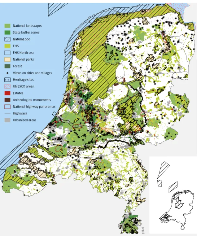
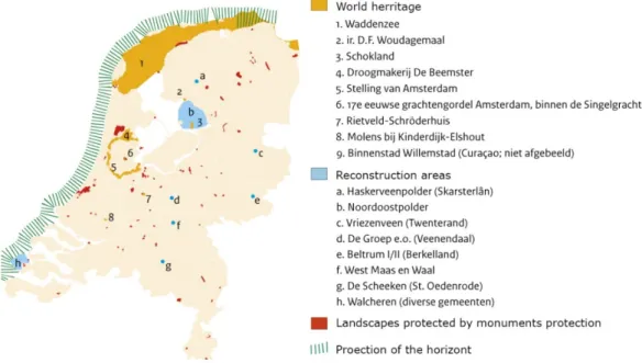
Figure 6. Landscapes of national importance in 2008 (PBL, in preparation)
Figure 6 shows all protected areas of the Netherlands in the ‘glory days’ of national
landscape protection in 2008. At that time, 160 Natura 2000 areas (EU nature policy), NEN, 20 national parks, 20 national landscapes and 10 national buffer zones were delineated and strongly protected, and 9 national highway panoramas were roughly indicated (for the definition of these categories, see the appendix). Next to that cultural heritage sites such as UNESCO protected areas, estates, archaeological monuments, protected views on city and villages were also protected.
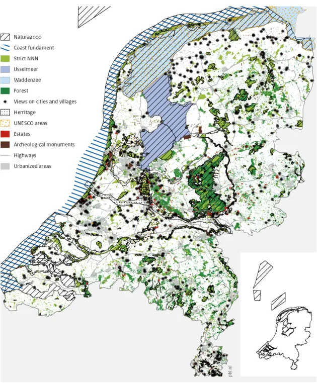
Figure 7. Landscapes of national importance in 2017 (PBL, in preparation)
In 2018, after decentralisation of the landscape policy parts of the Natura 2000 and some aspects of the Nature Network Netherlands remained under national protection (for instance financing). Deciding about the extensions of the natural areas and the way that they will be developed and designed were delegated to the provinces. Protection of the part of the landscape that previously belonged to the cultural heritage stayed unchanged. National landscapes, state buffer zones and highway panorama policies have been deregulated. National parks stayed in the national policy as areas with specific qualities, but more as branding, but without specific protection regime. This is due to the fact that National parks are the core areas within NNN and Natura 2000 and therefore are already protected. The
text box 4 shows how landscape policy deregulation worked in the case of national buffer zones.
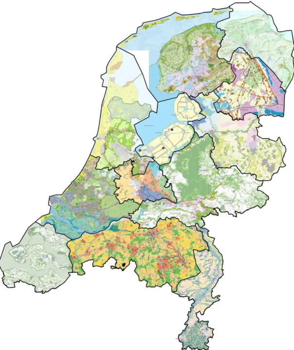
In the past years, each of the 12 provinces has created its own spatial development vision (Provinciale ruimtelijke structuurvisies) which, as Figure 8 shows, very much differ in their approaches to landscape planning.
Figure 8. Maps assembled form the twelve Provincial vision plans (Provinciale ruimtelijke
structuurvisies) by the national advisor for landscape in 2015
(
Text box 4: National buffer zones
In Dutch spatial policy, the national buffer zones (NBZs) are regarded as the greatest landscape protection success because of their continuity, successful combination of protection and development, and strong planning safeguards.
NBZs have been included in the national planning agenda, for more than 50 years. They were first mentioned in a forerunner of the regularly published series of national planning strategies, the planning document on western Netherlands (Nota Westen des Lands, 1958). Until 2009, NBZs have been an essential tool in national planning; first as
necessary separations between the country’s largest urban areas. Later, parts of the NBZs were transformed into large recreational areas. The policy style changed, too: from mono-functional buffers that prevent cities from expanding too far towards each other to multi-functional areas for agriculture, nature development and recreation. In the last part of that period, even the construction of buildings for recreational purposes was allowed under the condition that they would align with the character of the surrounding rural landscape. First, seven buffer zones were created in the Randstad to prevent Amsterdam, The Hague, Rotterdam and Utrecht from expanding into one ribbon-shaped super city. Two additional buffer zones were later envisaged for the urban conglomerate in the south-eastern
Netherlands, encompassing the cities in South Limburg (e.g. Maastricht, Heerlen and their suburbs). In 2008, the last buffer, park Lingezegen, was introduced in the Province of Gelderland.
Left: 10 national buffer zones in 2011. Right; changes in delineation of NBZs, since the decentralisation of landscape protection policy (Source: left: PBL CLO; right: PBL, in preparation)
NBZs show diversity in terms of geography and land use. Some of them encompass large areas with mixed forms of land use, villages, strip developments and greenhouses. By contrast, others include wide-open agrarian landscapes and vast stretches of water. Some NBZs come closer to the more familiar idea of a regional park, with park areas, woodlands and forests.
The oldest and most completed NBZ was Midden Delfland (between the Rotterdam Area and Delft). It was the only NBZ for which a special law was passed in 1977
(Reconstructiewet Midden Delfland) guaranteeing the legal and financial support for a ‘complete make-over’ of an area of over 5,000 ha. Because of this approach, this area so
far has remained open, while urbanisation has expanded all around it. Similar to Green Heart, Midden Delfland found itself in a horseshoe between the permanently growing cities and turned from being rural area to ‘land inside the city’ Tummers (1997).
In the later period, the strategy to keep buffers free from substantial urbanisation was supported by the creation of heavy ‘green areas’, which were supposed to keep all future urbanisation at bay. The example is the buffer between Amsterdam and Haarlem, which was to be converted into the park area Spaarnwoude, and parts of the park Lingezegen in North Brabant.
It is important to know that success of the NBZ was due to the crucial combination of strong degree of planning protection, and the land purchases by national government. All NBZs were delineated and taken over in the provincial spatial plans. It was the long-term reliable national policy and public landownership that moved urban development into other directions and created another reality: what is green has to stay green (Pols and Bijlsma, in Van der Wouden, 2015).
Until 2011, the national government continued to pursue the goals of protecting the NBZs through a restrictive building policy in combination with land acquisition for recreational use. In that period, building in NBZs was only permitted under the ‘No, unless’ principle; in other words, only if it contributes to the recreational value of the zone.
Since landscape policy has been decentralised to the provinces, the delineation and the level of protection of the NBZs changed, considerably. Some provinces kept the old protection regime completely as it was (Limburg), some even extended it (North Holland), while others (South Holland) removed restrictions on building in large parts of the old buffer zones, even allowing new housing construction.
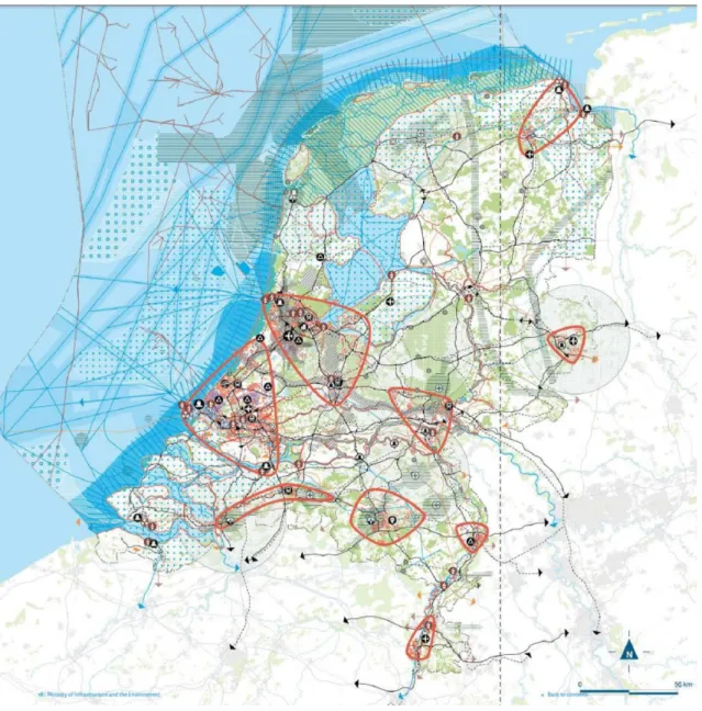
The last still valid national spatial planning document brought in 2012 is National Policy Strategy for Infrastructure and Spatial Planning (SVIR, see Figure 10). This document marks the final moment of the long period of government involvement in landscape planning. In the policy strategy, the national government took infrastructure, logistics and economic
competitiveness as the main own responsibilities and delegated urbanisation and nature policy to the provinces and municipalities. The map ‘Cultural-historical and natural qualities of national importance’ (Figure 9) presents the small parts of the landscape that remained under the concern of the national government.
Figure 9. Cultural heritage and natural qualities of the national importance, 2012 (CLO indicator 1339, 26 October 2012).
The map of National Spatial Structure, shown in Figure 10, reflects the current situation of landscape planning in the Netherlands: landscape is subordinate to urbanisation, mobility and economic developments. The integration of landscape—as it is desired in the European landscape convention (ELC), and ratified by the Netherlands in 2005—is at very low level in SVIR. At the same time, it is generally acknowledged that large spatial transformations are expected due to arising spatial claims from, for example, energy transition, climate change adaptation, urbanisation, and growing mobility. Lack of national involvement in managing spatial claims that exceed regional levels, leads to uncertainties and worries about the future of the landscapes in the Netherlands. A large amount of criticism emerges from the
perspective of nature protection society, as Dirx (2015) cynically states, there is no reason for grief, because in fact not too much has changed compared to the past. In Dirx’s opinion, landscape policy never existed and never had its own strong instruments, and the national policy had already been decentralised and deregulated, long before the establishment of the SVIR (Gerritsen et al., 2015).
3.1 Nature versus landscape protection
Ever since the landscape policy came into being, the government has been struggling with the question of what landscape really is and what it is supposed to be (Dirx, 2015). This also had to do with the constant changes in the definitions of landscape in policy documents, often being mixed with nature. But, while nature reserves have been purchased and
developed by the national and regional authorities, landscape as a whole stayed unprotected. Natural areas are spatially delimited and have a strong legal status. But with the landscape it looks completely different, it is everywhere and therefore hard to protect. Those were the reasons why nature development policy has become a success compared to landscape development policy.
Nowadays the landscape policy is partly deregulated and partly decentralised. But the government's role in nature development remains undiminished; it is still under the national government’s responsibility, putting in place an effective legal framework for nature
conservation and making sound international agreements. National government and the provincial authorities are jointly investing in the development of the National Ecological Network.
The 1990 Plan for the Preservation of Nature (Natuurbeschermingsplan) introduced the concept of the National Ecological Network (Ecologische HoofdStructuur, EHS) as system of uninterrupted dry or wet nature zones where building activities are forbidden, except for the very special purposes. The emphasis is strongly on protection of biodiversity in the narrow sense. This concept is criticised as outdated, as in the NEN, the landscape is not seen as a cultural phenomenon (Wagenaar, 2015). Also urban areas are not taken into account and the primary concern of the NEN remains nature and biodiversity protection in rural areas.
The latest national nature protection policy is presented in the document 'The Natural Way Forward: Government Vision 2014’. In this document, the government has sketched its new strategy on managing the natural environment up to 2025. The key aim of the vision is to bring about a change in thinking: nature should not be confined to nature reserves, but should be at the heart of society. Accordingly, people should care about nature in protected areas, but also about their natural surroundings closer to home. The government also presents some ideas of how this could be realised: farmers are creating wild-flower margins around fields; more urban buildings are being designed with 'green roofs'; there are
ecological noise barriers along motorways; local residents are maintaining communal
gardens or local nature areas; nature is being given space to flourish along rivers, which also protects the surrounding area against flooding; groups of farmers and locals are joining forces to preserve valuable landscapes; multinational companies are working to reduce their products' ecological footprint; tourism businesses are working on conservation projects with nature conservation organisations.
In the past, nature policy has traditionally focused on protecting nature from society, while this new vision aims to recruit society in the strengthening of natural assets. According to the Government Vision, the interests of nature and the economy can be complementary and serving one can benefit the other. ‘Second Nature’ is a programme that invites civil society organisations and private individuals to share their ideas on environmental stewardship: combining conservation with responsible social and economic use. However the presented approach broadens the concept of ‘nature’ and brings it closer to the meaning of landscape and integrated management, the problem is that it focus lies on the areas where nature is protected, not the landscape in the terms of ELC.
3.2 Spatial planning ‘new style’
Environmental legislation as it currently stands is scattered and spread over numerous other laws. There are separate laws relating to soil, construction, noise, infrastructure, mining, environment, preservation of historic buildings and sites, the natural environment, spatial planning and water management. This scattering of legislation gives rise to agreement and coordination issues, as well as reduced accessibility and usability for all users. To simplify this situation the national government currently works on the new Environment and Planning Act (Wro, expected to enter into force in 2021) and National Environmental & Planning Vision (NOVI, to be completed after the Act and would replace the SVIR). The Environment and Planning Act (Wro) defines how the spatial plans of the national government, provinces and municipalities are to be effectuated. This new Act seeks to modernise, harmonise and simplify currently distributed rules and integrate them into one legal framework. Land-use planning, environmental protection, nature conservation, construction of buildings, protection of cultural heritage, water management, urban and rural redevelopment, development of major public and private works and mining and earth removal will all be brought under one act.
The new Wro obliges national, provincial and sometimes municipal governments to develop an environmental strategy, an integrated and coherent plan for their physical territory. By integrating strategic planning instruments into the environmental strategy, by agreeing on multi-sectoral programmes with more implementation-focused policy tasks, and by
coordinating implementation, the government hopes to improve the efficiency of the planning process. The intention is to achieve a balance between continuity and certainty on the one hand and flexibility on the other.
The National Environmental and Planning Strategy (NOVI)2 is one of the six core
instruments3 of the Environment and Planning Act. NOVI promotes the coherence of policy
for the physical environment. As a result, in new visions various sectoral areas —water, environment, nature, use of natural resources, cultural heritage, and traffic and transport— are combined and connected. In the Environment and Planning Act, participation plays an important role. Many insights and views were obtained from other tiers of government and civil-society partners during the process prior to the initiation memorandum. The dialogue with other tiers of government and civil-society organisations, lobbyists and knowledge institutions is continued in the follow-up process for the preparation of the NOVI. The initiation memorandum of the NOVI is quite different from its predecessors. The
document presents thirteen layers of the physical environment and selects the priorities that governments should focus on, in the form of four strategic policy tasks: a sustainable and competitive economy; climate-proof and climate-neutral society; a future-proof and accessible living and working environment; and high-value living environment. In the
following three phases of the development of NOVI these strategic tasks will be elaborated in more detail, solution routes will be explored, a joint course will be determined, and a more comprehensive approach will be developed.
2 The new Environment and Planning Act (‘Omgevingswet’) will enter into effect on 1 January 2021. It is
combined with a single vision for the living environment in the Netherlands: the National Environmental Planning Strategy (NOVI). With the publication of an initiation memorandum in 2017 (‘De opgaven voor de
Nationale Omgevingsvisie’), the Cabinet took a first step towards the realization of the NOVI. In that
memorandum, the Cabinet – after due consultation with its partners – identified the strategic tasks for its environmental planning policy.
3 The six instruments are: the environmental planning strategy, programmes, general rules, environmental
In the NOVI approach, the layers of the physical environment are not shown on maps, as was the case in previous national planning documents. Instead, they are shown on a hypothetical area. The landscape is a part of the fourth strategic policy task and is also mentioned often as an important part of the other three tasks.
Figure 11. NOVI: strategic task: towards a high-value living environment
The main question is of the fourth strategic task (Figure 11) is: how can the values offered by the natural environment be maintained and utilised? This requires making choices with regard to the following issues:
1. Agriculture: choosing between food production under certain conditions or solutions for societal needs.
2. Is there a shortage of nature, or are expectations too high?
3. Taking either the landscape or the result of developments as the starting point. 4. Raising the water level in peat grasslands or maintaining current agricultural output. As the NOVI suggests, it is up to stakeholders to decide in which direction they would move the scale and the model would show the spatial consequences of their choices4
Although being integrated and multilevel, the NOVI model approach is currently causing many discussions in the professional and political circles which are used to formal planning tools such as mapping and calculations. Both the NOVI and the government vision, The Natural Way Forward, consider the landscape level as an important scale for planning and negotiation on spatial developments. Considering landscape as a common good is positive, but also creates uncertainty about who is responsible for it. Therefore, concerns about the future of Dutch landscapes are rising, putting it again on the national political agenda.
4 See for instance the animation on
4 The case of the
Green Heart of
Randstad
Green Heart a predominantly rural landscape between the four largest cities Amsterdam, The Hague, Rotterdam and Utrecht in the western part of The Netherlands, that form a ring shaped metropolis called Randstad (Figure 13). The term ‘Randstad’ was probably used for the first time around 1930 by aviation pioneer and first director of KLM Royal Dutch Airlines, Albert Plesman5. The green and open space within the city ring got the name ‘Green Heart’
and was officialised in 1958 in a number of reports, starting with ‘Ontwikkeling in het westen
des lands’ (development in the west of the country).
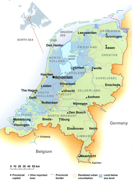
Figure 12. Location of the Green Heart in the Netherlands.
The Green Heart covers an area of roughly 1800 km2. It is surrounded by the metropolitan
areas of Amsterdam (to the north, 1 million), The Hague (to the west, 875 000), Rotterdam (to the south, 1.25 million) and Utrecht (to the east, 600 000). In January 2015, 726,541 residents lived in the 40 Green Heart municipalities, a tenth compared to the number of inhabitants in the metropolitan part of the Randstad area.
Today, the agricultural sector uses around 67% of the land surface of the Green Heart and earns its money mainly from the production of dairy, tree and horticultural products, the latter mainly concentrated in and around Boskoop. Ten per cent of the income in the Green Heart is earned with this primary agriculture (Rabobank 2012). The proximity of the ports of Schiphol and Rotterdam, processing and marketing centres and good infrastructure via road and rail provide good conditions for the export of agricultural products.
Although The Netherlands is one of the most populated countries in the world, Dutch cities are in comparison with the European and World metropolis quite small (the capital
Amsterdam has roughly 880.000 inhabitants). The Randstad concept therefore had not only spatial element (as Albert Plesman saw it) but, also a much more important economic one. By joining the population and economic forces of the four cities and presenting the region as one large city the government was hoping to give Randstad the prominent place on the map of Europe and make it economically competitive with other European regions. The Green Heart was seen as an important contribution to the quality of living in the densely populated urban area. In addition to its agricultural function, the Green Heart was also seen as a place of recreation for the citizens in the Randstad and of conservation of the green open space that is so characteristic for the Dutch polder landscape.
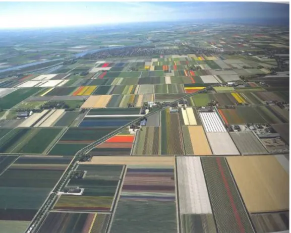
Figure 13. Impressions of the landscape of the Green Heart.
Source: PBL (upper and lower left), Natuurmonumenten-Ferry Siemensma (lower right) The Green Heart, similar to the rest of the Netherlands, a man-made cultural landscape, mostly consisting of polders, below sea level. Seen from the air, it looks like a large pasture, interwoven with larger or smaller waterways and scattered small cities and villages. Looking closer it shows heterogeneity, made up of very different relatively old landscape types, the oldest of which date back to the medieval times (around 1100 AD). The Green Heart is still rich in monuments of cultural heritage. Especially in the peat cultivation landscapes and along the river dykes, where historical strip settlements (road or dyke based) are abundant, we can still find hundreds of well-preserved historic farmhouses. Windmills, sometimes grouped in clusters of three or more, arguably make up the most striking landmarks in the Green Heart, by now, all of them have lost their original function as pumping engines (Figure 13).
In spite of urbanisation developments in past years, in a few areas of the Green Heart still come across as the archetypal Dutch landscape, calling to mind the landscape paintings of old masters, such as Ruysdael and Van Goyen.
In the following sections, we underline the differences in landscape approach affecting the Green Heart during the two planning periods: hierarchical and network planning.
4.1 Green Heart during the hierarchical planning period
The reasons why the Green Heart was announced as the iconic Dutch landscape were partly historical and partly strategic. Since the concept appeared, policymakers, especially those at the former Ministry of Housing, Spatial Planning and the Environment (VROM), were eager to protect the area as a green open space for agriculture and recreation and prevent its further urbanisation. In 1999, the ministry published a report on the development programme for the national landscape of the Green Heart (Ontwikkelingsprogramma nationaal landschapGroene Hart), which paints an idyllic future for the Green Heart, where agriculture, nature,
recreation and culture are in harmony and reinforce each other. This political intention was repeated in the Fifth National Policy Document on Spatial Planning (Vijfde Nota Ruimtelijke
Ordening, 2002). Although the research about the landscape appreciation of citizens and the
number of recreation activities in the open landscape of the Green Heart has shown to be the lowest compared to other areas in the country (Goosen, 2007), protection of landscape openness in Green Heart received a prominent place in spatial planning strategies. Gradually, the value of the Green Heart became broadly accepted in the society. So, persistent national policy had positive effects on the appreciation of the Green Heart in public opinion and by the organisations involved. In 2005 The Council for Rural Areas (De Raad voor het Landelijk
Gebied) which advised the government, placed the Green Heart along with eight other areas
in the premier league of national landscapes because of its rarity and importance to the national identity.
Over the course of time, economic development inevitably led to the expansion of
urbanisation, and threatened to fragment the landscape of the Green Heart. To prevent that, a series of national policies would lead to a seemingly vague limitation of the area allocated for urbanisation.
Figure 14. Changing boundaries of the Green Heart: a) indicative boundary; b) delineated boundary in 1990; c) indicative boundary 2017.
In this period, in order to keep the Green Heart open, the official Dutch policy was threefold: (1) impose restrictions on residential and industrial developments within the area; (2)
provide alternative space for development in new towns and urban expansion outside the region; (3) improve the quality of landscape and nature within the area itself. But because of the large demand and scarcity of land for urban and economic expansion, it took years before the boundaries of the Green Heart were firmly delineated. The boundaries of the Green Heart (Figure 14) were defined for the first time in 1990, in the Supplement to the Fourth National Policy Document on Spatial Planning (Vierde Nota over de Ruimtelijke
Ordening Extra,Vinex), and elaborated in the Green Space Structure Plan (Structuurschema Groene Ruimte) from 1992 (Kooij, 2010).
Nevertheless, the protection policy of the Green Heart only existed for 10 years. The combined policies, in which restrictions were mixed with development measures, has for many decades been a successful approach for this vulnerable area. In the course of time, the general tendency changed towards deregulation, decentralisation and privatisation. The national government dismissed the landscape protection policy and delegated those tasks to the provinces. This change threatened to reduce the Green Heart to what it had been before in the 1960s, the hinterland of a number of individual cities and towns, each with its own development plans (Kooij, 2010).
The pressure on the landscape of the Green Heart continues, and as we can see on the example of the city fringe of Leiden (Figure 15) the policy alone, however strict it was in the past years was only partly effective in halting the urbanisation of the Green Heart.
1960 1990 2017
Figure 15. Urban expansion of the eastern side of Leiden from 1960 till 2017.
Together, the building restrictions in the Green Heart, the policy of compact extension of the Randstad and the creation of new towns (under VINEX) could not stop all development in the Green Heart. Today, the average population density of the Green Heart lies at the 475 inhabitants per km2, certainly not a figure that seams in line with area's image of a
non-urban, open landscape. The rapid growth of the surrounding new towns, however, suggests that the outcome could have been different if there was no policy at all (Lorzing, 2004). As this experience shows, landscape reconstruction, nature conservation and heritage protection could only work within the framework of a consistent, long-term policy and financial support at a high administrative level. Unfortunately these conditions only lasted for
the certain period of time and the changing context required finding new ways of dealing with the pressures of urbanisation.
4.2 Green Heart in the network planning period
Since the beginning of this millennium spatial policy is shifting from controlling and restricting to stimulating and supporting. Nowadays coalitions between differentgovernmental levels and various other actors are engaged in a large number of landscape projects.
A growing number of bottom-up initiatives is emerging, all promoting and applying an integrated landscape development approach on larger or smaller scale (Figure 16). As it can be seen from the examples presented in the Text boxes 2 and 3, coalitions between the actors can have variety of forms and arrangements and be directed towards various spatial interventions. Within the framework of current legislation and subsidy system they aim to maximise the use of available means so to combine several targets in a common
development programme.
Figure 16. Promoting various values of the Green Heart (Source: PBL, LGN, Stichting TOP Routenetwerken)
The Green Heart region also had to restructure its forces and find the new way of protecting and promoting the region. The multi-stakeholder platform, a coalition between
entrepreneurs, societal organisations and government called Steering Committee National Landscape Green Heart (‘Stuurgroep Nationaal Landschap Groene Hart’) was formed. The Steering Committee includes representatives from the three provinces (South Holland, North Holland and Utrecht), a regional water authority and municipalities (Figure 17). It focuses on achieving concrete results with 10 core projects on topics such as land decline, spatial quality and recreation. The Steering Committee supports the municipalities that take the lead in the promotion, for example when drawing up plans for the future generally by knowledge sharing, but sometimes also with financial means. Branding became the key word, raising the economic importance by attracting visitors and offering touristic attractions and local agricultural products are part of it.
Another organisation called The Green Heart Foundation has been committed to preserve the character of the Green Heart, with all its culture, landscape and nature values. Together with private sector, NGOs, residents and local governments the Foundation counts 250 active rural entrepreneurs and more than 2,500 friends of the Green Heart. The Foundation actively works on marketing and promotion (Stichting Merk en Marketing Groene Hart) of the Green Heart. Through the Quality Atlas (www.kwaliteitsatlas.nl) the foundation monitors the core qualities of the Green Heart6.
Figure 17. Organisation of the Steering Committee of the Foundation Green Heart
The multi-stakeholder platform Green Heart functions in a way as an additional governance layer in the management of the region. This example fully fits in the philosophy of the ILM and shows the benefits that joined forces and shared responsibilities can bring to the region. Text box 5 about the Green Clove Association shows how this integrated approach works on the ground.
6 The Green Heart foundation publishes weekly journal Green Flash, contains cultural tips, political reports at
municipal and provincial level, research reports and high-profile opinion pieces. The newsletter reaches more than 7,500 digital addresses every week. In addition, the foundation publishes Green Heart Life every quarter, a glossy magazine with interviews and reports about this traditional Dutch region. The foundation also offers space for debate, for example, it organizes a quality tour or symposium several times a year, which deals with issues such as mobility, problem of vacancy of farms or nature development in the Green Heart.