SPATIAL MODELLING
OF PARTICIPATORY
LANDSCAPE SCENARIOS
Synthesis and lessons learned from
exploring potential SDG progress in
3 case studies
Spatial modelling of participatory landscape
scenarios
Synthesis and lessons learned from exploring
potential SDG progress in 3 case studies
This publication can be downloaded from: www.pbl.nl/en. Parts of this publication may be reproduced, providing the source is stated, in the form: Meijer, J, Shames, S Scherr SJ and Giesen P. (2018). Spatial modelling of participatory landscape scenarios: synthesis and lessons learned from exploring potential SDG progress in 3 case studies. PBL Netherlands Environmental Assessment Agency and EcoAgriculture Partners, The Hague.
PBL Netherlands Environmental Assessment Agency is the Dutch national institute for strategic policy analysis in the fields of the environment, nature and spatial planning. We contribute to improving the quality of political and administrative decision-making by conducting outlook studies, analyses and evaluations in which an integrated approach is considered paramount. Policy relevance is the prime concern in all of our studies. We conduct solicited and unsolicited research that is both independent and scientifically sound.
EcoAgriculture Partners is a non-profit organisation advancing the practice of integrated agricultural landscape management and the policies and tools to support it. By facilitating shared leadership and collaborative decision-making by all stakeholders in a landscape, EcoAgriculture Partners empowers agricultural communities to manage their lands to enhance livelihoods, conserve biodiversity and ecosystem services, and sustainably produce crops, livestock, fish and fibre. The organisation serves as the secretariat for the global partnership Landscapes for People, Food and Nature Initiative (LPFN).
Spatial modelling of participatory landscape scenarios: synthesis and lessons learned from exploring potential SDG progress in 3 case studies
© PBL Netherlands Environmental Assessment Agency The Hague, 2018
PBL publication number: 2613
Corresponding authors
johan.meijer@pbl.nl, sshames@ecoagriculture.org
Authors
Johan Meijer, Paul Giesen (PBL), Seth Shames and Sara J. Scherr (EcoAgriculture Partners)
Supervisor
Keimpe Wieringa
Acknowledgements
The authors greatly appreciate the support and inputs to the framing and analysis of the landscape processes from Solidaridad, IUCN-NL, A Rocha Ghana and African Wildlife Foundation, enabling the case studies in Honduras, Ghana and Tanzania. We thank Justin Johnson of the University of Minnesota for his work and support on the application of the MESH tool. We also thank the participants in the case study stakeholder workshops for their collaboration, and the participants in the ‘Spatial Modelling in relation to the SDGs’
expert workshop, held in November 2016 at the University of Twente’s Faculty of Geo-Information Science and Earth Observation, for sharing their expertise. We thank the NLandscape platform and its members for their support in organising and participating in the seminar, held on 11 June 2018 in The Hague, which provided valuable feedback on the results of this report and provided input for the next steps. We thank PBL colleagues Marcel Kok, Mark van Oorschot, Stefan van der Esch, Paul Lucas, Aafke Schipper and Alexandra Tisma for their thoughts and suggestions during the project and while reviewing the draft report. Finally, we thank Omer van Renterghem of the Dutch Ministry of Foreign Affairs for catalysing the PBL-EcoAgriculture collaboration.
Graphics
Johan Meijer, Paul Giesen and PBL Beeldredactie
Production coordination
PBL Publishers
Contents
MAIN FINDINGS
4
1 INTRODUCTION
6
1.2 Achieving the Sustainable Development Goals at the landscape scale 6
1.2 Objectives of the project 7
1.3 Report structure 7
2
METHODOLOGY
8
2.1 Modelling framework 8
2.2 Selection of the case study landscapes 10
2.3 Stakeholder-driven scenario development 10
3
OVERVIEW OF THE CASE STUDIES
15
3.1 Honduras: the Caribbean North Coast landscape 15
3.2 Ghana: the Atewa-Densu landscape 19
3.3 Tanzania: the Kilombero valley landscape 23
4 LESSONS LEARNED
29
4.1 Data, modelling and scenario development 29
4.2 Multistakeholder platforms and collaborative planning 30
4.3 National and international policy relevance of the scenario models 31
5
NEXT STEPS
33
5.1 Spatial modelling and data 33
5.2 Building on synergies with other landscape tools 33
5.3 Linking with ongoing policy and planning processes 33
Main findings
enhance our perception of how these drivers are affecting natural resources in a landscape and the people that depend on them.
Spatial modelling of alternative future scenarios can be a catalyst for building landscape partnerships, and for bringing to the surface and refining stakeholder
assumptions, analyses, and negotiations around strategy, production and resource management practices and spatial planning.
Although integration and robustness of feedbacks between the currently used tools can be further improved, they can signal progress on the SDGs and identify trade-offs and synergies among SDG indicators. They are particularly well-suited for the assessment of interactions between agricultural production and ecological values at a landscape scale, though modelling the impacts of ecosystem health on agricultural production is a research area that is still undergoing development. Further research can promote the combination of tools, also relating to governance and finance, and drive the development of new tools that work in an integrated manner at the landscape scale and are capable of assessing progress towards attaining a broader range of SDGs, including those covering socio-economic, gender, education and institutional aspects.
The Sustainable Development Goals are designed as an integrated and inseparable framework and are therefore useful for focusing discussions on shared ambitions and benefits, and can be combined with spatial scenario analyses to plan actions for integrated landscape initiatives.
Integrated Landscape Management (ILM) is a way of managing the landscape that involves collaboration among multiple stakeholders, and has the purpose of achieving sustainable landscapes. There are myriad different approaches, entry points, and organisational models, but what they have in common is an emphasis on achieving multiple social, economic and environmental objectives within the same large socio-ecological area, over the long-term. Altogether, this forms a promising institutional model for implementation of the SDGs at the meso scale.
Assessing changes in SDGs under various future scenarios produces useful insights for analysing and comparing potential trade-offs and synergies, provided that the various Goals are well-presented in the model’s underlying The objective of this project is to explore and combine a
set of modelling tools into a framework that is able to capture local and spatially explicit landscape
characteristics and use these to compare several plausible future scenarios that have been developed through a participatory, multi-stakeholder process. This project focus, the linking of participatory scenarios for the sustainable development goals (SDGs) to
multi-stakeholder landscape planning processes, is a substantial innovation.
Our research considers the following two questions: 1) What is the potential of existing spatially explicit modelling tools to project impacts and interaction among multiple SDGs, and how can these tools be most efficiently and effectively used, combined and developed? And 2) how can these modelling tools, including scenario
development, be effectively utilised in the context of multi-stakeholder landscape initiatives?
Within the context of the project, we organised a spatial modelling expert workshop focusing on the SDGs, which concluded that a spatially explicit, integrated and flexible modelling framework covering a wide range of SDGs was not yet available. However, the workshop did identify several components as promising elements for detailed landscape level assessments: the CluMondo land systems simulation tool in combination with the GLOBIO4 biodiversity impact model and the MESH ecosystem service supply mapping tools, have the potential to cover the SDGs selected in this project: food (SDG2), water (SDG6), climate (SDG13) and life on land (SDG15).
These tools and the developed methodology are applied in three case studies of landscape planning processes, in Honduras, Ghana and Tanzania. These landscapes are experiencing rapid growth in population, expansion and commercialisation of the agricultural sector, high rates of rural poverty, and both agricultural and non-agricultural pressures on their natural resource bases. Together with the stakeholders, we develop and put forward alternative scenarios and make projections of impacts up to the year 2030.
The main lessons we learned from this project are:
Spatial modelling tools can help to increase awareness among stakeholders about landscape dynamics and the weight of drivers of landscape change, such as a growing population and increasing urbanisation, the expansion of agricultural production and the development of
logic. Scenarios based on integrated approaches co-designed by stakeholders from multiple sectors, demonstrate the potential to achieve progress on multiple SDGs simultaneously. Multistakeholder platforms can be effective in facilitating the implementation of these approaches.
Modelling of landscape scenarios can effectively engage and influence relevant policymakers. The process demonstrates the importance of decisions on public and private land and on resource use with regard to a range of economic, social and environmental objectives. When policymakers are actively engaged in modelling processes they are motivated to clarify their assumptions and expectations around a range of development pathways along with the other landscape stakeholders. This was evident in each of the landscape case studies.
Integrated Landscape Management (ILM) is the process by which managers and stakeholders can plan, implement and monitor actions to support their goals, including the SDGs, at a workable scale. ILM is suited for landscapes where there are strong interactions and interdependencies around natural resource use and management. In most such places, government policies alone cannot resolve trade-offs or mobilise synergies between goals.
Stakeholders need to be directly involved in negotiations and make commitments to incorporate collaboratively agreed strategies and objectives into their own businesses and programmes (Ros-Tonen et al., 2018).
An effective ILM process can create an improved
understanding among stakeholders of the conditions and dynamics in the landscape, and result in a plan for action that includes win-win interventions, realises
opportunities for blended investments, and mobilises collaborative action to improve institutional and policy conditions. Integrated Landscape Management, regardless of the ‘entry point’ for action in a particular landscape or the community of practice, has five key features (Scherr, Shames and Friedman, 2013):
1. There are shared or agreed management objectives that encompass the economic, social and environmental outputs and outcomes desired by stakeholders in the landscape (commonly human well-being, poverty reduction, economic development, food and fibre production, climate change mitigation, and conservation of biodiversity and ecosystem services). 2. Field, farm and forest practices are designed to
contribute to those multiple objectives.
3. Ecological, social, and economic interactions among different parts of the landscape are managed to realise positive synergies among interests and actors or to mitigate negative trade-offs.
4. Collaborative, community-engaged processes are in place for dialogue, planning, negotiating and monitoring decisions.
5. Markets and public policies are shaped to achieve the diverse set of landscape objectives.
ILM implementation generally follows a cycle with five key elements: formation and organisation of the multi-stakeholder platform; development of a shared understanding among stakeholders of landscape challenges and opportunities; agreement on broad ambitions for the landscape, strategies to achieve them, and an action plan; implementation, with refined intervention design, associated investment and policy action; and monitoring and impact assessment to inform
1.2 Achieving the Sustainable
Development Goals at the
landscape scale
In September 2015, the global community adopted the 2030 Agenda for Sustainable Development, which includes a set of 17 Sustainable Development Goals (SDGs) and 169 targets. The SDGs provide a comprehensive, integrated and inseparable framework for countries to plan and achieve an integrated development vision for 2030. The key aspect, here, is integration, as there may be competition for resources between the individual development goals. Spatial planning and land governance are becoming more and more important as cumulative pressures from the demands for food, feed, biofuels, nature conservation, and urban expansion lead to increasing competition for natural resources and have an impact on the flows of ecosystem services. This may be either direct competition between various types and management forms of land use within countries, or competition spurred by international trade between countries (Van der Esch et al., 2017). The specific actions that are required to achieve the 2030 development vision of countries will need to be planned and implemented at sub-national scales where
stakeholders are able to more clearly understand the impact of specific actions. In conjunction with national and regional spatial planning, interactive and adaptable spatial and land-use-planning processes need a strong bottom-up component where the overlapping interests of a range of stakeholders can best be integrated within a multifunctional landscape (CBD, 2014; UNCCD, 2017). A landscape is a socio-ecological system that is organised around a distinct ecological, historical, economic and socio-cultural identity (Denier, et al., 2015). The landscape therefore seems a manageable unit where the SDGs can be integrated (Thaxton, et al., 2015). In a landscape approach, stakeholders aim to reconcile competing social, economic and environmental objectives. While ensuring the realisation of local level needs it also considers goals and outcomes important to stakeholders outside the landscape, such as national governments, international supply chains or the international community (Van der Horn and Meijer, 2015). Conservation, sustainable management, socio-economic development and restoration are integral parts of this conceptual framework.
identified several components as promising elements for detailed landscape level assessments. Therefore, the focus of this project, linking scenario models for SDGs to multi-stakeholder landscape planning processes, is a substantial innovation.
Based on the workshop findings, a landscape scenario modelling framework was piloted. It consists of various tools and is designed to be tightly linked to the processes and activities that stakeholders are already working on, collaboratively. The scenario building exercises were informed by input and feedback from local stakeholders through workshops, discussions and field visits. The models and scenarios aimed to help stakeholders better understand how ongoing trends are shaping their landscape at the social, economic and ecological levels. Based on that understanding, the stakeholders can make use of the models and scenarios to articulate their ambitions for the landscape in more concrete terms, and make explicit their assumptions about how various sets of landscape actions – including policies, standards and investments – are expected to impact the landscapes, assessed by analysing progress on SDGs such as ‘Zero Hunger’, ‘Clean Water and Sanitation’, ‘Climate Action’, and ‘Life on Land’.
The spatial modelling and scenario development activities in this project have been undertaken with two sets of users in mind. The first is formed by the landscape stakeholders, who included a wide range of actors including
representatives of farmer organisations, conservationists, business interests, local government actors and CSO representatives from a variety of sectors. In each of the selected landscapes, a group of landscape stakeholders were actively collaborating–with varying levels of intensity–to transform their landscapes in more
sustainable directions. Participatory scenario development was designed to deepen the shared stakeholder
understanding of the landscapes and to motivate sharper analysis of options and impacts. The second set of users is formed by policymakers at landscape, regional, national and international levels who seek to advance spatial planning for sustainable development. This report aims to provide insights into both sets on the ways that scenario modelling tools can be used in landscape initiatives to achieve progress on meeting the SDGs through integrated landscape-scale modelling that is stakeholder, multi-sector and spatially-explicit.
1.3 Report structure
Section 2 describes the methods used in developing the the next cycle of stakeholder action. Spatial analysis and
land-use planning, potentially, play a strategic role in each of these elements, helping to identify those land uses and management regimes that best meet the demand from stakeholders in different parts of the landscape, while safeguarding soil, water, and biodiversity for future generations.
1.2 Objectives of the project
Supported by the Netherlands Ministry of Foreign Affairs, PBL Netherlands Environmental Assessment Agency and EcoAgriculture Partners collaborated to develop, apply and assess the use of spatially explicit modelling and scenario tools to help stakeholders in integrated landscape initiatives to explore strategies aimed at achieving multiple SDGs. The objective of this project is to combine a set of modelling tools into a framework that is capable of capturing local and spatially explicit landscape characteristics and use them to compare several plausible future scenarios that have been developed through a participatory, multi-stakeholder process.
A key element in this project is the notion that many activities and impacts in a landscape are spatially and temporally interactive or inter-dependent on each other, particularly in the stock and flow of ecosystem services. Our aim was to make the stakeholders in the case study landscapes more aware of these interactions, to discuss their ambitions and to analyse how these could all be realised in the landscape, taking into account available resources and public, private and civic objectives relating to spatial planning and land use. We make efforts to assess trade-offs and synergies by looking at changes in land use and various ecosystems services and how these changes are affecting progress towards fulfilling the landscape stakeholder ambitions and the selected SDG indicators on food (SDG2), water (SDG6), climate (SDG13) and life on land (SDG15).
Our research considers the following two questions: 1) What is the potential of existing spatially explicit modelling tools to project impacts and interaction among multiple SDGs, and how can these tools be most efficiently and effectively used, combined and developed? And 2) how can these modelling tools, including scenario
development, be effectively utilised in the context of multi-stakeholder landscape initiatives?
Inspired by recent literature on modelling national pathways to achieve SDGs (Allen et al., 2017 and Wood et
2 Methodology
The section begins by laying out the details of the modelling framework developed by this project. This includes the technical elements of the model as well as its effort to link to specific SDG indicators. It then describes how the pilot landscapes were selected and how the participatory scenario development processes were administered, in each case.
With the intention to assess various spatial tools, the core modelling tools selected for this project are the CluMondo land systems simulation model, for analysing land-use change in response to market demand and policy
interventions (Van Asselen and Verburg, 2013), the GLOBIO model that assesses impacts on biodiversity from human-induced pressures (Schipper et al., 2016), and the MESH tool, based on various InVest modules (Sharp et al., 2018), which maps changes in ecosystem services (Johnson et al., in prep). From these model outcomes, we derived a number of indicators that represent the selected SDGs, as listed in Table 2.1.
Figure 2.2 shows how these tools are connected and how the information represented in the conceptual model in Figure 2.1 flows from input data and assumptions to output indicators. We also explored the MESH-SDG tool, an extension to the MESH tool still in development, which tries to relate ecosystem supply changes to individual SDG indicators based on findings from Wood et al. (2018). These tools are all open source and freely available. Their characteristics and applications are explained in more detail in the separate case study reports and were used in collaboration with researchers from the VU University Amsterdam, University of Minnesota (Natural Capital Project) and Bioversity International (a CGIAR Research Centre).
When additional spatially relevant model outcomes and SDG indicators were considered by the stakeholders, these outcomes were explored and analysed if suitable data was available. For example, assumptions on livelihood improvements, such as on income and consumption, in certain cases, based on views from local experts and stakeholders, could also be considered as an implicit part of scenario interventions (i.e. when assuming
improvements in land ownership or applying improvements in agricultural diversification and production).
2.1 Modelling framework
The ambition of the modelling was to connect demands and drivers from various spatial scales (per landscape, national, global) and to integrate the actions of stakeholders that are affecting the landscape. The conceptual framework for the model is illustrated in Figure 2.1. Scenario interventions are expected to influence socio-economic drivers and land-use regulation and practices at the local level.
The modelling framework in this project centres on the spatial configuration of activities in the landscape and the resulting impacts on natural resources. Because of this orientation, the framework does not include input or impact of economic or employment sub-models; it does define economic drivers of change at the landscape level. The indirect impacts are assumed to be reflected in the parameters used. It is assumed that during the scenario period no significant changes in the price trends for inputs and commodities will occur that would modify incentives for investment or changing practices beyond the storylines of the scenarios analysed.
The model emphasises impacts on the stakeholders’ landscape ambitions and on selected SDGs (focusing on SDGs 2, 6, 13 and 15, see Table 2.1) resulting from changes in land-use, agricultural production and practices, and ecosystem services dependent on the natural resources in the landscapes.
There are additional factors that affect the achievement of the ambitions and SDGs, such as institutional services and effectiveness, and complementary investments in built infrastructure. Therefore, the project focuses more on comparing outcomes between various scenarios and the change from the current situation than the actual achievement of official SDG targets. For many of these targets the current definition and distance to the target is unknown, uncertain or the required data that was unavailable.
Figure 2.1
Landscape interventions
Institutions Land access Risks
Context for land regulation, management and markets
Prices
Effects on land-use
Land system Suitability: population distance to roads/rivers, markets, soil, topography,
local climate
Changes in ecosystem services
Food Water Erosion control Carbon storage Biodiversity Economic, social and environmental benefits to stakeholders Impacts on SDGs Direct: * Poverty * Food and hunger * Water quality and quantity * Climate * Life on land, biodiversity Indirect: * Health * Gender * Sustainable production and consumption * Other...
Landscape level drivers and demands
Demographics Technology Economic development Consumption change
Socio-economic drivers Demands
Urban Agriculture, forestry Energy Nature
Feedback on drivers and demands
Source: PBL
Conceptual modelling framework for the scenario analysis
Table 2.1
Selected SDGs and model outcome indicators
SDG Related target Theme Model outcome indicators
2 2.1–2.3 Food provisioning Change in food provisioning, defined as the sum of the caloric value of all agricultural food production (based on Johnson et al., in prep) in the landscape, taking scenario changes in productivity and impacts from water quality into account.
2 2.4 Sustainable land use Change in share of food production complying with spatial land-use policies supporting and protecting ecologically vulnerable areas 2 2.4 Sustainable land use Change in share of agro-export production complying with spatial
land-use policies supporting and protecting ecologically vulnerable areas
6 6.3 Water quantity Change in water available in the landscape for agricultural use 6 6.3 Water quality Change in water purification function for nitrogen
6 6.3 Water quality Change in water purification function for phosphate 6 6.6 Water quality and soil
conservation Change in sedimentation prevention function, indicating erosion control 6 6.6 Aquatic ecosystems Change in share of riparian zones under ecologically compatible
production or conservation management 13 13.2 Climate Change in carbon storage in soils and vegetation 15 15.1 Land system Change in forest or forested area, which includes mosaics 15 15.5 Biodiversity Change in Mean Species Abundance as a measure of local
biodiversity intactness, which represents the mean abundance of original species in relation to a particular pressure as compared to their mean abundance in an undisturbed reference situation 15 15.2 Protected areas Change in natural land cover in protected areas
15 15.2 Supporting bio-corridors Change in share of area of bio-corridors complying with spatial land-use policies supporting and protecting the function of bio-corridors.
2.3
Stakeholder-driven scenario
development
After the case study landscapes and local partner organisations were identified, the research was organised in 4 phases: (1) gather landscape information and datasets to support the creation of a 2030 business-as-usual scenario; (2) organise a landscape stakeholder workshop to present the first outcomes and collectively design alternative scenarios and identify integrated landscape interventions with stakeholders; (3) produce preliminary results of the scenario analysis and report on the impacts of these interventions for feedback; (4) generate feedback on the outcomes from landscape stakeholders for revision and final reporting of the results.
The setup of each case study was adapted to the planning process of the local partner, in order to find synergies with planned meetings and to limit the additional workload for them and the stakeholders involved. In Honduras, the scenario workshop was integrated in a Landscape Leadership Workshop, and, in Tanzania, it was co-organised with a workshop on Landscape Investment and Finance. The Honduras study built upon a landscape assessment, land-use analysis and stakeholder interviews undertaken by EcoAgriculture and Solidaridad in 2016 (Castro-Tanzi and Gross, 2016). In Ghana, results from earlier
2.2 Selection of the case study
landscapes
A list of potential cases was created during the preparatory phase of this project in 2016, drawing from the Landscapes for People Food and Nature (LPFN) initiative1 partner
organisations. Three case study landscapes were then selected to pilot the project. These were the Caribbean North Coast landscape in Honduras, the Atewa-Densu landscape in Ghana and the Kilombero valley landscape in Tanzania.
The selected landscapes fit our criteria of varying in area size, population size, boundary delineation options, entry points of the main challenges as perceived by the local partner and the characteristics and roles of the local partners (Table 2.2).
The most important criteria, however, were that in these three landscapes, some level of collaborative planning activities was already ongoing and that key data required for spatial modelling was available. The latter was achieved in part by connecting to larger research initiatives: i.e., the SINIT facility and CREDIA-PROCORREDOR project in Honduras, the TEEB-Atewa project in Ghana and the African Biodiversity Conservation Group (ABCG) in Tanzania, in which the African Wildlife Foundation participates.
Figure 2.2
Scenario demands and applied spatial policies
Urban, food production, cash crops, grazing, timber, mining, etc. including assumptions on productivity
Demands Spatial rules
Land systems allowed in i.e. riparian zones, protected areas, bio-corridors, buffer zones, etc. based on input from stakeholders CluMondo land systems simulation MESH ES carbon storage water quantity water quality erosion control MESH ES food provisioning GLOBIO4 impact on biodiversity
Landscape suitability layers
I.e. population, soil properties, climate, elevation, slope, distances to markets, settlements,
roads, rivers and ports
Landscape level outcomes on
land-use change, sustainable and supportive use, export crop production
forest area and human land use in PA and supporting zones
Additional scenario input:
Temperature (SSP2) Precipitation (SSP2) Infrastructure developments
Scenario landuse maps current to 2030
Landscape change SDG indicators: SDG 2: Food
Food provisioning Food produced sustainably Agri-export crops produced sustainably
SDG 6: Water
Water purification (Nitrogen) Water purification (Phosphate) Water available for agriculture Sedimentation prevention function Sustainable use of riparian zones
SDG 13: Climate
Carbon storage
SDG 15: Life on land
Forest area (incl mosaics) Biodiversity in Mean Species Abundance
Natural land cover in protected areas Sustainable use of bio-corridors
Source: PBL
Identifying landscape ambitions and assessing progress towards them
The identification of landscape ambitions was a two-stage process. In the first stage, we consulted with our partner organisations in landscapes to identify key documents that laid out some landscape ambitions already proposed, and to identify options for more sustainable agricultural practices and natural resource management. For Honduras, these were retrieved from various government agencies, NGOs and universities, and the initial landscape assessment paper produced in 2016. In Ghana, a TEEB report written specifically to assess the value of the Atewa forest was the starting point and many other research and policy reports on water, cacao, palm oil and smallholder agriculture were explored. In Tanzania, we drew on a combination of the SAGCOT ‘Greenprint’ report for Kilombero and various other documents, such as those covering the activities of AWF, an assessment by the Convention on Wetlands (also known as the Ramsar Convention) and scientific papers analysing changes in the Kilombero catchment. The information in these documents was supplemented with stakeholder interviews conducted during the initial field visits. The second stage of this process occurred during a workshop in each landscape in which the landscape ambitions identified during the desk study and interview stage, and initial scenario results, were presented to workshop participants to stimulate discussions. During these facilitated workshops, participants had an
opportunity to revise and refine these ambitions, identify concrete actions to achieve them and communicate how the scenarios should be changed to better reflect the local conditions and scenario storylines. The scenarios were revised based on this feedback and the modelling outcomes were updated and reported.
To operationalise the interventions suggested by the stakeholders and to assess the scenario outcomes on progress towards the landscape ambitions, in each case study a number of spatial policy layers were created to guide, promote or restrict certain activities or land uses under a certain scenario. Both the current situation and the scenario outcomes were assessed in terms of their contribution to the landscape ambitions, based on these policies in combination with changes in land use, meaning that for instance the expansion of urban area or palm oil plantations in a protected area or riparian zone were considered undesired by the stakeholders and therefore classified as area used in a way that is not supporting progress towards achieving the ambitions. stakeholder consultations and scenarios developed for the
TEEB report (IUCN NL et al., 2016) provided the starting point for our analysis. The Tanzania study drew on insights gleaned from the ‘SAGCOT Greenprint’ project done in 2013 (Milder et al., 2013), which included an analysis of potential agricultural green growth opportunities in the Kilombero SAGCOT cluster. These previous studies enabled the research team to have some understanding of the history, economic and ecological dynamics, relevant land-use categories, and sustainable land-land-use options available. Therefore, the team could more easily interpret
stakeholder inputs and flag inconsistencies or gaps needing further clarification.
The process of selecting the elements of the scenarios was designed to be as participatory as was practical given the circumstances in each of the landscapes. This process included preparatory landscape visits by PBL and stakeholder meetings, individually and in groups, which were intended to gather a wide range of stakeholder perspectives, ideas and expertise of the stakeholders in the development of the scenario storylines.
Landscape visits, data sharing and stakeholder input
Each pilot landscape was visited twice, and these visits were organised and facilitated by the local partners. The first visit, by PBL, was used as a scoping visit to develop familiarity with the landscape, collect existing landscape analyses and data, consult with various stakeholders to understand their landscape ambitions and identify the interventions that would be needed in order to achieve these ambitions. Based on this information, business-as-usual scenarios for the year 2030 were developed for the Honduras and Tanzania landscapes and applied to the modelling framework to produce some first outcomes. In consultation with the local partner, three scenario storylines for the Ghana landscape were taken from the IUCN Atewa forest TEEB report and expanded to cover the whole Atewa-Densu landscape.
During the second visit to each landscape, a stakeholder workshop was organised. Workshop sessions were held with stakeholders about the current state, trends, and priorities for interventions in the landscape. The draft scenario analyses were presented for group discussion and recommendations. Based on the feedback, the model assumptions, scenario storylines and the interventions were refined. The new results were reported to the case study partners for feedback, which was again used to improve the case study reports.
Figure 2.3
Overview of the case study landscapes at scale
0 165 330 660km Tanzania Ghana Honduras Kilombero valley landscape Atewa-Densu landscape Litoral Norte landscape Source: PBL Table 2.2
Characteristics of the case study landscapes
Northern Coast, Honduras Atewa-Densu, Ghana Kilombero valley, Tanzania
Landscape
boundary Based on watersheds Based on districts Combined: SAGCOT 2 cluster, watersheds, administrative wards
Area 22,000 km2 6,000 km2 16,000 km2
Population 3.5 million 5.5 million 0.6 million
Landscape initiative stage
Multi-stakeholder platform (MSP) in place
Collaborative planning process, with various stakeholders
Collaborative actions, exploring MSP start-up
Entry point, main challenge
Sustainable palm oil production in line with food security and a sustainably managed landscape
Protecting Atewa forest as a water source for expanding urban settlements and agriculture
Protecting wetlands and bio-corridors, while promoting sustainable agricultural development
Figure 2.4
Visualisation of the Trend scenario and ambitions of the landscape stakeholders to be included in an integrated landscape scenario
Visualisation of the scenarios
A key element in the project was to make explicit how various types of activities and impacts in a landscape are spatially related. To illustrate the significance of these interactions between the different elements in the landscapes, the challenges facing the stakeholders and the potential effect of various foreseen interventions, PBL landscape architects designed 3D landscape visualisations for each case study, which were used in exercises and discussions during the stakeholder workshops. For example, Figure 2.3 illustrates potential impacts under the Trend scenario as well as how various interventions in the landscape interact and could support the ambitions of the stakeholders, under an integrated landscape management strategy on the Honduras landscape.
More information on these visualisations is included in the case study reports.
Notes
1 The Landscapes for People, Food and Nature Initiative, convened by EcoAgriculture Partners, is a global coalition of nearly 80 Strategic Partners to scale up effective landscape approaches to achieve agricultural production, healthy ecosystems and local livelihoods (peoplefoodandnature.org).
2 In 2010, the Government of Tanzania launched the Southern Agricultural Growth Corridor of Tanzania (SAGCOT) initiative as a public-private partnership dedicated to ensuring food security, reducing poverty and spurring economic development in Tanzania’s Southern Corridor.
3 Overview of the case studies
The spatial modelling and participatory scenario methodology was applied for 3 case study landscapes. This chapter provides a brief overview of the main characteristics and outcomes of the individual landscape case studies. A more detailed description of the case studies, the stakeholders, the scenarios and the outcomes can be found in the separate case study reports (Meijer and Scherr, 2018; Meijer and Shames, 2018; Meijer, Shames and Scherr, 2018).
To operationalise the interventions suggested by the stakeholders and to assess the scenario outcomes on progress towards the landscape ambitions, a number of spatial policy layers were created to guide, promote or restrict certain activities or land uses under each scenario (Figure 3.2). Both the current situation and the scenario outcomes were assessed in terms of their contribution to the landscape ambitions, based on these policies in combination with changes in land use.
Outcomes of the scenario analysis
The first scenario outcomes were presented at a workshop in Tela, in May 2017. They provided the stakeholders with insights on the current situation in the landscape and on the main drivers of change under a business-as-usual scenario: 30% increase in population, related increases of urban areas and demand for food, doubling of palm oil production, mainly by area expansion, and further encroachment on protected areas and bio-corridors. This stimulated discussion on how they would achieve the various ambitions in the landscape over the next 15 years. For comparison with a business as usual (BAU) scenario two alternative pathways were designed: an Accelerated Agricultural Export Growth (AAEG) scenario that builds on the BAU scenario but aims at achieving higher rates of growth in the production of agricultural export commodities, especially palm oil, pineapples, bananas and sugar cane, mainly by expanding the area under cultivation and without improvements in management practices, land-use planning or effective protection of protected areas and biological corridors.
The other alternative pathway was the Integrated
Landscape (ILM) scenario, which focused on implementing suggested interventions that aim to diversify income sources (i.e. via agroforestry cocoa and varied fruits production), halt the unbridled expansion of oil palm plantations into vulnerable areas, increasing productivity of current plantations, promote the use of crop-forest
3.1 Honduras: the Caribbean North
Coast landscape
Socio-ecological context
The Caribbean North Coast of Honduras (Litoral Norte) encompasses a vast, vibrant landscape that contributes to both the economy and conservation goals of the country and supports the livelihoods of 3.5 million inhabitants. An important share of the agro-industrial export commodities sold by Honduras in the international markets is farmed and processed in the floodplains of the major rivers of northern Honduras that flow into the Caribbean Sea. Several important and rapidly growing cities are located in the landscape.
The landscape partnership
In this landscape, Solidaridad, a global agricultural development organisation founded in the Netherlands, is implementing the PASOS programme (Paisajes Sostenibles en Honduras or Sustainable Landscapes in Honduras). This integrated landscape partnership was built upon an already functioning partnership among actors involved in the palm oil sector. PASOS includes a broader range of landscape stakeholders, including palm oil, cocoa and ecotourism companies; indigenous people’s and community-based organisations; farmer organisations and cooperatives; municipal governments; research institutes and universities; community water associations; and non-profit organisations.
Landscape ambitions
Key ambitions of this partnership include improving rural livelihoods and food security, increasing RSPO-certified sustainable palm oil production, expanding the area and increasing productivity of cocoa agroforestry systems, sustainably managing watersheds for human, agricultural and ecological needs, building resilience to flooding, climate change and extreme weather events, expanding sustainable eco-tourism, and conserving and expanding
Figure 3.1 Tela Tocoa La Ceiba Olanchito El Progresso Puerto Cortes
San Pedro Sula
Urban Intensive mono-agriculture Palm oil Shrubland Mangrove Wetland Forest Bare Water Mixed crop-livestock
Mixed crop-livestock with some forest Agroforestry mosaic
Cash tree crops 0 15 30 60km
The North Coast landscape in Honduras, land systems in 2014
Landscape situated in Honduras
Source: PBL Figure 3.2 Tela Tocoa La Ceiba Olanchito El Progresso Puerto Cortes
San Pedro Sula
No policies or restrictions Riparian zones
Protected areas
Bio-corridors High flood risk zones Steep slopes (>30%) 0 15 30 60km
Spatial policies covering the North Coast landscape in Honduras
Landscape situated in Honduras
BAU and AAEG scenarios on the selected SDG indicators, as Figure 3.5 shows. Given the scenario projections on population, climate change and agricultural production, the ILM is the only scenario that has positive outcomes for 3 of the 4 SDGs, or is able to limit degradation, compared to the BAU and AAEG scenarios. This does illustrate the scale of the challenges faced in the landscape, but also the potential value of a process that explicitly encourages and enables stakeholders from multiple sectors to coordinate strategies.
Interpretation of the results, uncertainties and impact on the process
To achieve the landscape ambitions, investments are needed to increase palm oil productivity and RSPO certification, and to promote cocoa production in sloping areas and agroforestry in more ecologically vulnerable areas while increasing productivity and incomes. Together with institutional development and enforcement of spatial land-use policies, increasing ecotourism development and improve land titling and ownership, these form the foundation of the Integrated Landscape scenario. The Solidaridad PASOS programme is supporting progress on these issues in this landscape.
However, given the overall scenario projections on population and urban area increase, impacts from climate change, and the scale of land-use transformation required in various sectors, it will be challenging to achieve or even improve on the Integrated Landscape scenario. It will require serious financial investments from the private to improve water quality, minimise soil erosion and
decrease risk of landslides and effects from flooding. Furthermore, protected areas and bio-corridors in the landscape, which also offer important eco-tourism opportunities, are maintained or restored.
The outcomes illustrate some significant differences between the three scenarios, as shown by Figures 3.3 and 3.4, providing an overview of land-use changes projected in the landscape, and the area used for activities
supporting and affecting progress towards the ambitions. The area affected by spatial policies for the most critical areas needing ecosystem protection covers 53% of the entire landscape area, which is quite significant.
By complying with the spatial policies, the area in use with supportive land-use/land-cover practices increases from 71% in 2014 to 92% under the ILM scenario, compared to a decrease to 58% and 59% under the BAU and AAEG scenarios, respectively, mainly caused by uncontrolled expansion of palm oil production, further deforestation and unsupportive land-use practices (e.g. oil palm plantations and intensive agriculture) in riparian zones, protected areas and bio-corridors. Several larger urban areas (e.g. the main harbour town of Puerto Cortes) and large oil palm plantations in the eastern Aguan Valley are located in areas identified as high-risk flood zones. Since relocation seems unrealistic here, even under the ILM scenario, making these areas resilient against flooding requires implementing larger scale water development and management plans, which are not included in our
Figure 3.3
Urban Intensive mono-agriculture Palm oil plantation Shrubland, mangroves, wetands Forest broadleaf Forest needleleaf Mixed crop-livestock systems Mixed crop-livestock with some forest Agroforestry mosaic Cash tree crops
0 2000 4000 6000 8000 10000 km² Source: PBL pb l.n l 2014 Business-as-usual Accelerated Agricultural Export Growth Integrated Landscape Land use for current situation and 2030 scenarios in the Honduras landscape
Figure 3.5
SDG2: Food Food provisioning Food produced sustainably Agri-export crops produced sustainably SDG6: Water Water available for agriculture Water purification (Nitrogen) Water purification (Phosphate) Sedimentation prevention function Sustainable use of riparian zones SDG13: Climate Carbon storage SDG15: Life on land Forest area (incl mosaics) Biodiversity in Mean Species Abundance Natural land cover in protected areas Sustainable use of bio-corridors
-50 -25 0 25 50
% change compared to the current situation
pb l.n l Business-as-usual Accelerated Agricultural Export Growth Integrated Landscape Impact on selected SDGs under scenarios compared to the current situation in the Honduras landscape
Current situation
82%
Source: PBL
Figure 3.4
2014 BAU AAEG ILM
0 20 40 60 80 100
% of spatial policy zone
Source: PBL pb l.n l Steep slopes High-risk floodzones Bio-corridors Protected areas Riparian zones Supporting ambitions Land-use affecting progress on landscape ambitions in the Honduras landscape
agricultural cooperative REDMUCH, and PROLANSATE, who are all involved in the Solidaridad PASOS programme.
3.2 Ghana: the Atewa-Densu
landscape
Socio-ecological context
The Atewa Range, lying about 90 km north of the capital Accra, is a strip of unique upland forest surrounded by a mixture of farms, small scale gold mines and villages (Figure 3.6).
The forest is considered a globally significant biodiversity area and functions as the source of three important rivers: the Densu, Birim and Ayensu. It supports several
communities who live on the forest fringes, as well as being home to a large diversity of plants and animals. market assistance necessary to combine strategies for
sustainable palm oil production with food production, water management, tourism development and the conservation and restoration of protected areas. To stimulate various financial flows to the landscape, the results from this case study were used by the PASOS programme in a Landscape Investment Finance workshop to refine business plans for key interventions, and a Landscape Finance Journey bringing potential investors to the landscape.
The model outcomes presented here and in the separate case study report are based on available data sets and spatially explicit modelling, with only limited interactions, various assumptions and a moderate level of complexity. To explore the options for achieving the Integrated Landscape scenario in more detail and develop concrete landscape action plans, more advanced socio-economic,
Figure 3.6 KADE KIBI ACCRA SUHUM BEGORO NSAWAM AMASAMAN KOFORIDUA ASAMANKESE
TEMA MUNICIPAL AREA
The Atewa-Densu landscape in Ghana, land systems in 2015
District boundaries Atewa forest (core)
Atewa buffer zone (220m altitude) Rivers
Urban/settlements Mixed crop-livestock
Mixed crop-livestock with forest Agroforestry mosaic
Cocoa plantations Palm oil plantations Mining Closed forest Open forest Wetlands Water (lakes/reservoirs) 0 15 30 60km Source: PBL The landscape situated in Ghana
the remaining high-value biodiversity of Atewa and its role as a water source for currently 5.5 million people.
Landscape ambitions
The Living Landscape Vision is centred on the development of a National Park with an associated tourism industry. The area around the National Park would form an enterprise zone where sustainable land-use practices including natural forest restoration, agro-forestry and commercial reforestation would be encouraged. In the workshop exercise, the key goals that A Rocha and its partners discussed were the development of a National Park in Atewa and the supporting buffer zone, the management of the Densu watershed, growth in food production in the landscape, the growth of sustainable palm oil production and cocoa agroforestry, and the development of an eco-tourism industry.
As in the Honduras case, we operationalised the interventions suggested by the stakeholders by creating a number of spatial land-use policies as layers. These layers guide, promote or restrict certain activities or land uses dependent on water downstream in the three river basins,
including businesses, the households of the capital Accra, as well as local communities and farmers that live in the landscape, totalling over 5.5 million people. The landscape was delineated according to district boundaries, covering in total 24 districts, 12 of which are located in the Eastern region and 12 in the Greater Accra region.
The landscape partnership
An NGO, A Rocha Ghana, has been working in the Atewa Range since 2012, with the support of IUCN Netherlands. They are convening relevant stakeholders for the purpose of protecting the forest and the water that flows from it, while providing for sustainable livelihood opportunities for inhabitants of the landscape. This has led to the development of the Atewa Living Landscape Vision that aims for an integrated landscape that respects the region’s history, its environment and its people, and one that brings development to the region in a sustainable way. This work was catalysed by an explosive growth in gold mining around Atewa and the risk of large-scale bauxite mining activities that could potentially destroy the core zones of
Figure 3.7 KADE KIBI ACCRA SUHUM BEGORO NSAWAM AMASAMAN KOFORIDUA ASAMANKESE
TEMA MUNICIPAL AREA
Spatial policies covering the Atewa-Densu landscape in Ghana Steep slopes Atewa bufferzone
Protected areas, forest reserves or RAMSAR sites Riparian zones No policies or restrictions 0 15 30 60km Source: PBL The landscape situated in Ghana
connecting stakeholders by the fluctuating flow of water of the Densu River, which is declining in quality. Based on the scenarios from Atewa forest TEEB report three pathways were designed: a business-as-usual scenario (BAU) that follows the TEEB report assumptions on the impact from gold mining and expands the analyses by taking into account the impacts from population growth over the next 15 years, the expanding area needed for food production and the ambitions of Ghana to remain under the specific scenarios (Figure 3.7). Both the current
situation and the scenario outcomes are assessed on their support to the landscape ambitions based on these policies in combination with changes in land use. For example, the expansion of urban area or mining in a protected area or riparian zone are considered undesired by the stakeholders and therefore not supporting progress towards achieving the ambitions and SDGs.
Outcomes of the scenario analysis
Figure 3.9
2015 BAU TAR Living Landscape
0 10 20 30 40 50 60 70 80 90 100
% of spatial policy zone
Source: PBL pb l.n l Steep slopes Atewa bufferzone Protected areas Riparian zones Supporting ambitions Land-use affecting progress on landscape ambitions in the Ghana landscape
Figure 3.8
Urban Mixed crop-livestock Mixed crop-livestock with forest Agroforestry mosaic Cocoa plantations Palm oil plantations Mining Closed forest Open forest 0 500 1000 1500 2000 km² Source: PBL pb l.n l 2015 Business-as-usual Taking all Resources Living Landscape Land use for current situation and 2030 scenarios in the Ghana landscape
pathway, to keep up with the effects from a rapidly growing population and halt further degradation of crucial ecosystems and their services.
Figure 3.10 shows that most of the selected SDG indicators are higher in the Living Landscape scenario than under the business-as-usual and Taking all Resources scenarios. To produce sufficient food and create a sustainable livelihood for the current and an additional projected 2.5 million people, will require improved water quality and the protection of soils and forest. It will thus be essential to maintain the green infrastructure on which a sustainable future in the Atewa-Densu landscape needs to be built, both protecting the Atewa forest reserve and restoring the supporting buffer zone.
The only exception from Figure 3.10 is that of water provisioning for agriculture, which describes–and is reflected in the modelling tools–the trade-off between having less trees or more trees in the landscape as they consume and hold water and, therefore, more trees leave relatively less water available for agricultural production. Unfortunately, due to increasing erosion, pollution and sediment flow, the increasing water provisioning under the BAU and TAR scenarios is more likely to cause trade-offs (increased run-off, uncontrollable timing of available water flow, risk of flooding) than synergies. From the perspective of citizens in urban Accra, the availability of will be completely degraded because of intensive mining
activities for gold and bauxite.
The third, ILM-inspired, Living Landscape scenario focuses on the protection and restoration of the Atewa forest, designated as a national park, and restores the supporting buffer zone by the promotion and increased productivity of mixed cacao agroforestry activities, the landscape-wide implementation of the riparian zone policy, and more integrated spatial planning at the district level. Many of these ambitions are being taken on by A Rocha in their collaboration with IUCN-NL and the relevant district assemblies. The latter have been challenged by the national government to integrate the SDGs in their 4-year development plans.
As shown in Figure 3.9, the Living Landscape Vision pathway clearly best supports the landscape ambitions, by implementing the riparian zone policy, restoring the Atewa buffer zone and implementing effective
management of the Atewa forest as a national park, combined with a restriction on mining activities in these zones. If the Atewa forest is not to be used for bauxite mining, serious investments are needed to increase agricultural productivity and incomes in food and agroforestry production activities. More effective enforcement of laws and regulations and support to district planning capacities are the foundation of this
Figure 3.10
SDG2: Food Food provisioning Food produced sustainably Agri-export crops produced sustainably SDG6: Water Water purification (Nitrogen) Water purification (Phosphate) Water available for agriculture Sedimentation prevention function Sustainable use of riparian zones SDG13: Climate Carbon storage SDG15: Life on land Forest area in PA and bufferzone Landscape biodiversity in MSA Biodiversity in MSA in PA and bufferzone Sustainable use of bufferzone
-50 -25 0 25 50
% change compared to the current situation
pb
l.n
l
Business-as-usual Taking all resources Living landscape Impact on selected SDGs under scenarios compared to the current situation in the Ghana landscape
Current situation
-110%
3.3 Tanzania: the Kilombero valley
landscape
Socio-ecological context
The Kilombero valley landscape of Tanzania (Figure 3.11) is bounded by the Kilombero River (south-east) and the Udzungwa Mountains (north-west). It is characterised by highland forest along the Udzungwa escarpment to the west, transitioning into a large lowland wetland system with the Kilombero River at its centre. Rice and sugar cane are produced in the lowland areas, transitioning into banana, some cocoa and maize in the boundary area, interspersed with teak plantations. The population is predominantly composed of smallholder farmers who are largely dependent on rivers, springs and streams for their water supply for both domestic and productive uses. Approximately half of the population is considered to be food-insecure as a result of (1) low yields due to climate change, soil degradation, poor inputs, pests and disease, and insufficient water, and (2) external factors, such as inadequate access to markets and financial services, human-wildlife conflicts, insufficient land, and conflicts over control of natural resources.
A growing human population, expanding agricultural production (especially for rice, maize and sugarcane), unplanned land-use conversion, livestock grazing (by pastoralists migrating from the north), poor forest and waterway management, and changing weather patterns due to climate change are putting extreme strain on the natural forest and wetland systems and on the
downstream water users who depend on them. This is threatening both the ecological functions those systems provide and their core values to biodiversity, including several rare and endemic species, such as the red colobus monkey, sanje mangebey, and puku antelope. Also threatened are several major wildlife corridors that are crucial to maintaining connectivity between Tanzania’s two largest elephant populations anchored by the Selous Game Reserve to the east and Ruaha National Park to the west.
The landscape partnership
The African Wildlife Foundation (AWF) is working in this area to demonstrate how agricultural productivity and biodiversity conservation goals can be balanced within a landscape context. They are already working with partners to set up a ‘payments for ecosystem services’ programme in several upstream villages to promote more efficient and sustainable water use and a programme for small-scale water for drinking is currently not seen as much of an
issue, though the quality and the cost of treating it for consumption are becoming problematic. Famers in the Densu basin area however, are facing unfavourable periods of drought recently, with the Densu river even falling dry at certain times.
Interpretation of the results, uncertainties and impact on the process
The 2016 TEEB report already highlighted the benefits of conserving the Atewa Range for the stakeholders in the surrounding area. In this study, the landscape was expanded to include the effects from the expansion of the capital of Accra and from agricultural developments in the mid-stream Densu area. This takes into account an additional 2.5 million people in the landscape by 2030 and related increases in agricultural production to fulfil the increasing demand for food. In that sense, the analysis has broadened the stakeholders’ awareness of the interactions within the landscape and could enlarge the coalition for the Living Landscape vision. There would seem to be more opportunities for synergies with existing initiatives and platforms, like the Densu Basin Board of the Water Resource Commission. Delineating the landscape on district boundaries and focusing on SDG-related indicators connect our modelling to the district level planning process, illustrating their role in the larger process and provide examples of how SDGs could be integrated in their plans.
The model outcomes presented here and in the separate case study report are based on available data sets and spatially explicit modelling, with limited sets of interactions, various assumptions and a moderate level of complexity. To explore the options for achieving the Living Landscape scenario in more detail and develop concrete landscape action plans, more advanced socio-economic, agronomic, hydrologic and ecological analysis would be useful.
Achieving the Living Landscape scenario under the projected 2030 circumstances will also require serious private sector investments in agricultural productivity and market development that is ‘landscape-friendly’. It will also require a commitment from national government to upgrade the Atewa reserve to a national park, maintain the current ban on small scale goldmining, and provide sufficient resources to regional and local level government bodies to develop and implement integrated development plans that aim at progress on all SDGs. Landscape finance plans are now being explored, to attract more investments and also provide communities involved in gold mining
in March 2018. Participants represented officials from various levels of government, water basin authorities, various large companies from the private sector, and NGOs.
In 2017, a multi-stakeholder Learning Platform around land-based investments was designed and implemented in the landscape (LANDac, 2018). That project aimed to bring stakeholders together, improve the quality and flow of information between them, and generate new ideas for creating shared value. Our work was able to benefit from this process.
In the workshop, all participants’ individual ambitions were determined and subsequently grouped into the Agricultural Growth Corridor of Tanzania (SAGCOT), a
public-private initiative dedicated to ensuring food security, reducing poverty and spurring economic development in Tanzania’s Southern Corridor through commercial agricultural development.
Landscape ambitions
An ‘agricultural green growth’ strategy for Kilombero was developed for SAGCOT in 2013, through consultation with local stakeholders, who identified a range of productivity-increasing, income-generating options while also protecting biodiversity and ecosystem services (e.g. ecological intensification, agro-processing, eco-tourism, sustainable energy) (Milder et al., 2013). The strategy was not widely disseminated or implemented, but elements were reflected in the project’s stakeholder workshop held
Figure 3.11 Sofi Udekwa Itete Minepa Idete Chita Kisawasawa Iragua Kimala Lupiro Ruhembe Kidatu Mlimba Biro Malinyi Mofu Kiberege Mang'ula Mchombe Chisano Kidodi Utengule Ukwega Mtimbira Ngoheranga Usangule Lumemo Kibaoni Mbingu Sanje Mkula Ifakara Ruaha Riva Riva Biro Butu Mofu Sofi Chita Idete Ifema Igata Igaua Irole Itete Mbasa Mgeta Mkasu Mlale Msita Ruipa Tanga Msolwa Chombe Iragua Kidatu Kidodi Libali Lupiro Manani Mbingu Merera Mfriga Mgawsi Mifama Mlange Mlimba Mpanga Ngombo Ngombo Solulu Ulambo Clalula Igwachu Ikurumi Ikwambe Kimenya Kiswago Lomango Mavimba Ngongwa Alyhanya Kiberege Kivukoni Kotakota Lohomero Mdambati Mpapalar Utengule Nyamhanga Kisawasawa Madabadaba Makalakatu Boma ya Ulanga 0 15 30 60km The Kilombero valley landscape in Tanzania, land systems in 2016
Source: PBL
Urban / settlements Intensive mono-culture Mixed crop-livestock
Mixed crop-livestock with forest (15-40%) Forest (>40%) with extensive agriculture Grassland Plantation forest Closed forest Open forest Shrubland Wetlands Water Bare Wards SUSTAIN focus
in layers. These layers guide, promote or restrict certain activities or land uses, under the specific scenarios (Figure 3.12). Both the current situation and the scenario outcomes are assessed on how they support the landscape ambitions, based on these spatial policies in combination with changes in land use. For example, agrochemical-intensive agriculture in a protected area or wetland would be considered undesirable by the stakeholders and classified as not supporting progress towards achieving the landscape ambitions.
following main themes: conservation (of forest cover, wildlife and bio-corridors), water (protection of water security and water access), livelihood improvement (food security, agricultural income, commercial development and energy security related to hydropower plants and developments, social development (equality, health and gender), sustainable management of crop and livestock areas (soil and water conservation and production efficiency) and governance (land-use-plan development and implementation, policy harmonisation, planning coordination, enforcement, accountability and
Figure 3.12
0 15 30 60km Spatial policies covering the Kilombero Valley landscape in Tanzania
Source: PBL
SUSTAIN focus areas
Kilombero Game Controlled Area Protected areas
Riparian zones (100m buffer)
Kilombero Valley Floodplain (RAMSAR) Bio-corridors
Steep slopes (>20%) No policies
intensive banana, citrus and rice production. However, it was not explored in more detail, as the wide-ranging group of stakeholders present at the time, considered this undesirable and infeasible.
the key documents, datasets and preparatory discussions with partners and landscape stakeholders. This assumed a 2.5% annual population growth, with consequent increase in food crop and livestock activities, and slight increases in forestry and mono-agricultural practices for rice and sugar cane, all without any improvements regarding land regulations, allocation and management.
Based on feedback during the workshop, assumptions on annual population growth were changed to 3.5%, crop production and livestock grazing activities were adapted. This Blueprint pathway focused on large (>200%) increases A possible Accelerated Agricultural Growth pathway was suggested, based on the original 2011 SAGCOT Blueprint ambitions (SAGCOT, 2011), and was briefly discussed. in
Figure 3.13
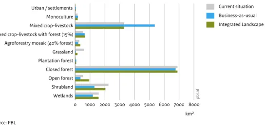
Urban / settlements Monoculture Mixed crop-livestock Mixed crop-livestock with forest (15%) Agroforestry mosaic (40% forest) Grassland Plantation forest Closed forest Open forest Shrubland Wetlands 0 1000 2000 3000 4000 5000 6000 7000 8000 km² Source: PBL pb l.n l Current situation Business-as-usual Integrated Landscape Land use for current situation and under 2030 scenarios in the Tanzania landscape
Figure 3.14 2016 BAU ILM 0 20 40 60 80 100
% of spatial policy zone
Source: PBL
pb
l.n
l
Bio-corridors, incl SUSTAIN focus areas Wetland and GCA
Protected areas Riparian zones Supporting ambitions Land-use affecting progress on landscape ambitions in the Tanzania landscape
limiting the loss of natural habitat. Due to reforestation and restoration within conservation areas, grassland even gradually develop back into open forests.
The Integrated Landscape scenario assumes strong territorial planning and collaboration among various organisations (government, NGOs and private sector) in order to successfully implement the various spatial policies. The costs and organisation to do so are not explicitly included in the model.
Together with substantial improvements in agricultural productivity and careful management of livestock grazing, the Integrated Landscape scenario is able to produce more food in a sustainable way, the same goes for cash crops, which could improve incomes for famers. The Integrated Landscape scenario is able to halt the further loss of wetland, limit deforestation and encroachment of protected areas, improve various riparian zones with income generating activities such as agroforestry, and also restore the viability of three bio-corridors in the
landscape, which could result in positive outcomes regarding the development of small-scale ecotourism. To stimulate positive momentum during the workshop,
most time was spent on defining a pathway that would contribute most to the identified ambitions. This was translated into a scenario that would focus on improving land management practices and agricultural productivity and marketing for small scale food crop production and grazing, effectively manage protected areas and reserves, and restore riparian zones with income generating agroforestry and mixed tree crops in the upper and lower areas of the catchment, also with the intention to improve water quality and secure water quantity. All these actions would contribute to the ambitions on economic and social development, and also to halting further encroachment on the Kilombero Valley Floodplain Ramsar wetland. To plan, enable and manage these actions, the improvement of land-use plans was also a core theme for the workshop, and assumed part of this scenario, with sessions facilitated by the Director General and other participants from the National Land Use Planning Commission.
Under the BAU scenario, most increases in agricultural land-use systems are causing losses of natural habitats, especially in open and closed forests, grass- and shrubland
Figure 3.15
SDG2: Food Food provisioning Food produced sustainably Agri-export crops produced sustainably SDG6: Water Water purification (Nitrogen) Water purification (Phosphate) Water available for agriculture Sedimentation prevention function Sustainable use of riparian zones SDG13: Climate Carbon storage SDG15: Life on land Forest area (incl mosaics) Biodiversity in Mean Species Abundance Natural land cover in protected areas Sustainable use of bio-corridors
-50 -25 0 25 50
% change compared to the current situation
pb l.n l Business-as-usual Integrated Landscape Management Impact on selected SDGs under scenarios compared to the current situation in the Tanzania landscape
Current situation